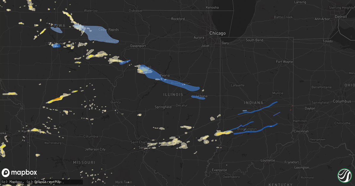
Hail Map in Illinois on June 15, 2019
Get this storm
June 15 map
$229
one time, instant access
Download today. No call, no setup
Keep the $229
Bought the map and want the full workflow? Apply the entire $229 to a subscription within 7 days. None of it is wasted.
Every map, not just this one
This buys you this map. Subscription and you get every map we run, in the markets you choose from a few cities to whole states to nationwide. Plus real-time alerts the moment a storm fires.
Contact data
Name, contact info, occupancy, even credit band for addresses in the footprint. You go from where it hit to who to call.
Become the source they trust
Unlimited branding weather history reports on demand. You already have the documented answer ready for the property owner, and you are the one who showed up with it.
Property data and RoofTrace estimates
Pull up any address you have got, its value and the exact code rules for that jurisdiction, straight from One Click Code. Then RoofTrace estimates the squares, pitch, and roof value, priced the way you price.
Storm reports in Illinois
Illinois
| Date | Description |
|---|---|
| 06/15/20192:50 PM CDT | Damage from tornado: 18 to 24 inch trees uprooted. |
| 06/15/20192:50 PM CDT | Tornado damage: tree down into a house and power lines down across town. Time estimated from radar. |
| 06/15/20192:47 PM CDT | Storm chaser observed a small tornado north of sawyerville. Time and location estimated based on picture and radar. |
| 06/15/20192:43 PM CDT | A weak tornado was observed and photographed by several individuals including a storm chaser and severe storm spotter. The tornado tracked west to east across the north |
| 06/15/20196:49 AM CDT | At 1149 PM CDT, a severe thunderstorm was located over Seymour, or 7 miles west of Champaign, moving east at 55 mph. HAZARD...60 mph wind gusts. SOURCE...Radar indicated. IMPACT...Expect damage to roofs, siding, and trees. Locations impacted include... Champaign, Urbana, Savoy, St. Joseph, Tolono, Philo, Sidney, Homer, Ogden, Bondville, Seymour, Sadorus, Ivesdale and Willard Airport.This includes the following highways... Interstate 57 between mile markers 224 and 238. Interstate 72 between mile markers 174 and 182. Interstate 74 between mile markers 179 and 197. |
| 06/15/20196:37 AM CDT | At 1137 PM CDT, a severe thunderstorm was located near Saybrook, or 11 miles southwest of Gibson City, moving east at 50 mph. HAZARD...60 mph wind gusts. SOURCE...Radar indicated. IMPACT...Expect damage to roofs, siding, and trees. Locations impacted include... Champaign, Rantoul, Mahomet, Fisher, Thomasboro, Gifford, Lake Of The Woods, Ludlow, Royal, Foosland, Dewey, Flatville and Penfield.This includes the following highways... Interstate 57 between mile markers 239 and 257. Interstate 74 between mile markers 169 and 178. |
| 06/15/20196:28 AM CDT | At 1127 PM CDT, severe thunderstorms were located along a line extending from near Cooksville to 6 miles west of Saybrook to near Le Roy, moving east at 45 mph. HAZARD...60 mph wind gusts. SOURCE...Radar indicated. IMPACT...Expect damage to roofs, siding, and trees. Locations impacted include... Paxton, Gibson City, Buckley, Gibson, Melvin, Loda, Elliott and Sibley.Including the following interstate... I-57 between mile markers 258 and 271. |
| 06/15/20196:13 AM CDT | At 1113 PM CDT, a severe thunderstorm was located near Waynesville, or near Clinton, moving east at 50 mph. HAZARD...60 mph wind gusts and nickel size hail. SOURCE...Radar indicated. IMPACT...Expect damage to roofs, siding, and trees. Locations impacted include... Clinton, Heyworth, Farmer City, Mansfield, Wapella, De Land, Waynesville, Weldon, De Witt, Lane, Clinton Lake Dam, Midland City, Hallsville, Galesville and Lodge.This includes the following highways... Interstate 72 between mile markers 171 and 173. Interstate 74 between mile markers 155 and 168. |
| 06/15/20195:43 AM CDT | At 1042 PM CDT, severe thunderstorms were located along a line extending from near Shelbina to near Paris, moving east at 45 mph. HAZARD...60 mph wind gusts and quarter size hail. SOURCE...Radar indicated. IMPACT...Hail damage to vehicles is expected. Expect wind damage to roofs, siding, and trees. Locations impacted include... Hannibal, Palmyra, Monroe City, Shelbina, Paris, Warren, Payson, New London, Perry, Fall Creek, Center, Frankford, Rensselaer, Curryville, Spaulding, Spencerburg, Emden, Adams, Hull and Plainville.This includes the following highways... Interstate 172 near exit 2. Interstate 72 between exits 4 and 10.This also includes Mark Twain Lake Recreational Area. |
| 06/15/20195:41 AM CDT | At 1041 PM CDT, a severe thunderstorm was located over Goodfield, or 7 miles south of Eureka, moving east at 50 mph. HAZARD...60 mph wind gusts. SOURCE...Radar indicated. IMPACT...Expect damage to roofs, siding, and trees. Locations impacted include... Bloomington, Eureka, Normal, Le Roy, Heyworth, El Paso, Lexington, Mackinaw, Hudson, Chenoa, Gridley, Minier, Danvers, Colfax, Downs, Goodfield, McLean, Deer Creek, Saybrook and Stanford.This includes the following highways... Interstate 39 between mile markers 0 and 17. Interstate 55 between mile markers 145 and 187. Interstate 74 between mile markers 109 and 154. |
| 06/15/20195:13 AM CDT | At 1013 PM CDT, a severe thunderstorm was located over Bellevue, or near Peoria, moving east at 45 mph. HAZARD...60 mph wind gusts. SOURCE...Radar indicated. IMPACT...Expect damage to roofs, siding, and trees. Locations impacted include... Peoria, East Peoria, Morton, Washington, Chillicothe, West Peoria, Metamora, Germantown Hills, Bellevue, Rome, Washburn, Spring Bay, Bay View Gardens, Peoria Heights, Cazenovia, Norwood, Mossville, Peoria International Airport and Low Point.This includes the following highways... Interstate 474 between mile markers 0 and 5. Interstate 74 between mile markers 87 and 95. |
| 06/15/20195:06 AM CDT | At 1006 PM CDT, a severe thunderstorm was located near Glasford, or 11 miles east of Canton, moving east at 45 mph. HAZARD...60 mph wind gusts. SOURCE...Radar indicated. IMPACT...Expect damage to roofs, siding, and trees. Locations impacted include... Peoria, Pekin, East Peoria, Morton, Bartonville, Creve Coeur, Marquette Heights, Tremont, Bellevue, Mackinaw, Delavan, Manito, Minier, South Pekin, Glasford, Hopedale, Green Valley, Deer Creek, Armington and North Pekin.This includes the following highways... Interstate 155 between mile markers 12 and 31. Interstate 474 between mile markers 5 and 14. Interstate 74 between mile markers 95 and 108. |
| 06/15/20194:47 AM CDT | At 947 PM CDT, a severe thunderstorm was located over Farmington, or 11 miles north of Canton, moving east at 45 mph. HAZARD...60 mph wind gusts and nickel size hail. SOURCE...Radar indicated. IMPACT...Expect damage to roofs, siding, and trees. Locations impacted include... Peoria, Canton, Chillicothe, Farmington, Elmwood, Princeville, Dunlap, Cuba, Hanna City, Glasford, Trivoli, Brimfield, Yates City, St. David, Williamsfield, Fairview, Laura, Elmore, Kickapoo and Norwood.This includes the following highways... Interstate 474 between mile markers 0 and 2. Interstate 74 between mile markers 63 and 87. |
| 06/15/20194:19 AM CDT | At 919 PM CDT, a severe thunderstorm was located over Woodhull, or 11 miles southwest of Cambridge, moving east at 30 mph. HAZARD...60 mph wind gusts. SOURCE...Radar indicated. IMPACT...Expect damage to roofs, siding, and trees. Locations impacted include... Kewanee, Cambridge, Galva, Orion, Woodhull, New Windsor, Alpha, Andover, Lynn Center, Osco, Bishop Hill, Henry County Fairgrounds, Ophiem, German Corner, Nekoma, Kewanee Municipal Airport, Ulah and Johnson-Sauk Trail State Park.This includes Interstate 74 in Illinois between mile markers 20 and33. |
| 06/15/20194:10 AM CDT | At 909 PM CDT, a severe thunderstorm was located near Galesburg, moving east at 45 mph. HAZARD...60 mph wind gusts and nickel size hail. SOURCE...Radar indicated. IMPACT...Expect damage to roofs, siding, and trees. Locations impacted include... Galesburg, Abingdon, Knoxville, Elmwood, Wataga, Oneida, Yates City, Williamsfield, Altona, London Mills, Victoria, Maquon, Rio, Gilson, East Galesburg, Henderson, St. Augustine, Snake Den Hollow, Galesburg Airport and Dahinda.This includes Interstate 74 between mile markers 34 and 68. |
| 06/15/20192:55 AM CDT | A local report indicates 59 MPH wind near CRAWFORD COUNTY AIRPORT |
| 06/15/20192:33 AM CDT | Multiple reports and photos via social media of wind damage. Large limbs off of trees and fence toppled on 8th street. Roof partially ripped off of a house. Metal canop |
| 06/15/20192:25 AM CDT | Several 6 to 8-inch diameter tree branches blown down. |
| 06/15/20192:20 AM CDT | At 720 PM CDT, severe thunderstorms were located along a line extending from near Lone Tree to near Ainsworth to near Abingdon, moving east at 40 mph. HAZARD...60 mph wind gusts and quarter size hail. SOURCE...Radar indicated. IMPACT...Hail damage to vehicles is expected. Expect wind damage to roofs, siding, and trees. Locations impacted include... Muscatine, Fairfield, Washington, Wapello, Columbus Junction, Durant, West Liberty, Wilton, Kalona, Lone Tree, Winfield, Riverside, Fruitland, Wayland, Morning Sun, Brighton, Richland, Ainsworth, Grandview and Conesville. |
| 06/15/20192:05 AM CDT | A local report indicates 60 MPH wind near 4 ENE MONTROSE |
| 06/15/20192:03 AM CDT | Numerous tree branches blown down... Including a 10-inch diameter branch. |
| 06/15/20191:52 AM CDT | Range of hail sizes. Hail fell for approximately 2 minutes beginning at 0152 cdt. |
| 06/15/20191:40 AM CDT | Large tree branches snapped. |
| 06/15/20191:20 AM CDT | Delayed report. |
| 06/15/20191:20 AM CDT | Large tree limb snapped. Delayed report. |
| 06/15/201912:40 AM CDT | Delayed report. Tree limbs blown down near lake vermilion. Time estimated. |
| 06/14/201911:54 PM CDT | A local report indicates 60 MPH wind near SEYMOUR |
| 06/14/201911:48 PM CDT | Multiple social media reports and photos of trees snapped near white heath. Time estimated from radar. |
| 06/14/201911:48 PM CDT | Corrected location. Multiple social media reports and photos of trees snapped near white heath. Time estimated from radar. |
| 06/14/201911:40 PM CDT | Six power poles were snapped along il-10 just west of lodge. |
| 06/14/201911:38 PM CDT | A machine shed was destroyed about 1.5 miles north of bellflower along 3850 e road. Debris was strewn about a mile downstream. Time estimated from radar. |
| 06/14/201911:36 PM CDT | Path length 2.0 miles... Width 50 yards... Peak wind speed 100 mph. A machine shed was destroyed about 1.5 miles north of bellflower along 3850 e road. Debris was strew |
| 06/14/201911:02 PM CDT | Tree down at intersection of market and lee streets just west of downtown. |
| 06/14/201910:43 PM CDT | Power line down. |
| 06/14/201910:31 PM CDT | Tree limbs down. |
| 06/14/201910:20 PM CDT | Path length 2.5 miles... Width 200 yards... Max wind speed 105 mph. Shed blown away. 18-24 inch trees uprooted. Power poles down north of christmas tree rd near highway |
| 06/14/20199:58 PM CDT | A local report indicates 60 MPH wind near ELMWOOD |
| 06/14/20199:49 PM CDT | Tree down on house. Time estimated by radar. |
| 06/14/20199:39 PM CDT | 3 power poles and 6 trees snapped in middle of town along carter st. Damage was sporadic and not concentrated in any one area. |
| 06/14/20199:37 PM CDT | Tree down. |
| 06/14/20198:38 PM CDT | A brief tornado damaged trees at and just east of a farmstead. Some trunks were snapped near the base. Maximum wind speeds were estimated around 100 mph. The tornado wa |
All States Impacted by Hail Map on June 15, 2019
Cities Impacted by Hail Map on June 15, 2019
- La Plata, MO
- Orrick, MO
- Excelsior Springs, MO
- Richmond, MO
- Rayville, MO
- Cunningham, KS
- Liberal, MO
- Lamar, MO
- Oronogo, MO
- Overbrook, OK
- Burneyville, OK
- Hereford, TX
- Monroe, IA
- Prairie City, IA
- Conde, SD
- Buffalo, OK
- Justiceburg, TX
- Olton, TX
- Kinderhook, IL
- Saint Paul, KS
- Altamont, KS
- Parsons, KS
- Franklinton, LA
- Lockney, TX
- Floydada, TX
- Morning Sun, IA
- Winfield, IA
- Follett, TX
- Wichita Falls, TX
- Henrietta, TX
- Eldorado, TX
- Newton, KS
- Fredonia, KS
- Matador, TX
- Flomot, TX
- Granada, MN
- Paducah, TX
- Hardin, MO
- Sandoval, IL
- Moundville, MO
- Cedar Vale, KS
- Meeteetse, WY
- Garwin, IA
- Marshalltown, IA
- Le Grand, IA
- Montour, IA
- Erick, OK
- Texola, OK
- Wayside, TX
- Amorita, OK
- Manchester, OK
- Peabody, KS
- Florence, KS
- Forsyth, MO
- Tulia, TX
- Okabena, MN
- Brewster, MN
- Heron Lake, MN
- Wilmore, KS
- Breda, IA
- Carroll, IA
- Dugger, IN
- Merom, IN
- Switz City, IN
- Worthington, IN
- Jasonville, IN
- Hutsonville, IL
- Carlisle, IN
- Sullivan, IN
- Linton, IN
- Robinson, IL
- Palestine, IL
- Manson, IA
- Reasnor, IA
- Otley, IA
- Pella, IA
- Fort Stockton, TX
- Sheffield, TX
- Ozona, TX
- Dryden, TX
- Longton, KS
- Perry, IA
- Rocksprings, TX
- Sonora, TX
- Norwich, KS
- Borger, TX
- Skellytown, TX
- Panhandle, TX
- Lovilia, IA
- Shidler, OK
- Claude, TX
- Washington, KS
- Hanover, KS
- Barnes, KS
- Joice, IA
- Lake Mills, IA
- Mahaska, KS
- Viola, KS
- Piedmont, KS
- Beaumont, KS
- Leon, KS
- Pocahontas, IA
- Palmer, IA
- Pomeroy, IA
- Fargo, OK
- Argonia, KS
- Marietta, OK
- Ostrander, MN
- Spring Valley, MN
- Grand Meadow, MN
- Walnut, KS
- Girard, KS
- Stockton, MO
- Petrolia, TX
- Panora, IA
- Yale, IA
- Gilson, IL
- Cameron, IL
- London Mills, IL
- Maquon, IL
- Knoxville, IL
- Abingdon, IL
- Monmouth, IL
- Saint Augustine, IL
- Galesburg, IL
- Berwick, IL
- Carmen, OK
- Dacoma, OK
- Aline, OK
- Shattuck, OK
- Latham, KS
- Pavillion, WY
- Riverton, WY
- Eureka, KS
- Electra, TX
- Iowa Park, TX
- Ogden, IA
- Taloga, OK
- Worland, WY
- Joplin, MO
- Carthage, MO
- Olney, TX
- Del Rio, TX
- Woodward, OK
- Emporia, KS
- Strong City, KS
- Cottonwood Falls, KS
- Medicine Lodge, KS
- Rose Hill, IA
- What Cheer, IA
- New Sharon, IA
- Harrold, TX
- Remsen, IA
- Le Mars, IA
- Conrad, IA
- Alden, IA
- Iowa Falls, IA
- Eldora, IA
- Whitten, IA
- Union, IA
- Dalhart, TX
- McCune, KS
- Colwich, KS
- Mount Hope, KS
- Independence, KS
- Burden, KS
- Truman, MN
- Saint James, MN
- Rolfe, IA
- Dumas, TX
- Bussey, IA
- Albia, IA
- Hamilton, IA
- Eddyville, IA
- Oskaloosa, IA
- Omega, OK
- Watonga, OK
- Kingfisher, OK
- Burkburnett, TX
- Dimmitt, TX
- Friona, TX
- Summerfield, TX
- Muleshoe, TX
- Nemaha, NE
- Hollenberg, KS
- Cherryvale, KS
- Gladbrook, IA
- Toledo, IA
- Granite City, IL
- Maryville, IL
- Troy, IL
- Collinsville, IL
- Glen Carbon, IL
- Newcastle, TX
- Plainview, TX
- Putnam, OK
- Custer City, OK
- Overbrook, KS
- Berryton, KS
- Lecompton, KS
- Flat Rock, IL
- Mooreland, OK
- Rochester, TX
- O'Brien, TX
- Rippey, IA
- Sigourney, IA
- Hedrick, IA
- Fremont, IA
- West Terre Haute, IN
- Paris, IL
- Cambridge, KS
- Grenola, KS
- Dawson, IA
- Oak Grove, MO
- Napoleon, MO
- Martinsville, MO
- Denver, MO
- Greentop, MO
- Kirksville, MO
- Novinger, MO
- Crocker, MO
- Wichita, KS
- Goddard, KS
- Gridley, KS
- Newburg, MO
- Rolla, MO
- Ponca City, OK
- Newkirk, OK
- White Deer, TX
- Andale, KS
- Mount Union, IA
- Olds, IA
- Mount Pleasant, IA
- Jefferson, IA
- Jamaica, IA
- Hannibal, MO
- Haven, KS
- Cleo Springs, OK
- Waynoka, OK
- Fairview, OK
- West Liberty, IL
- Sainte Marie, IL
- Newton, IL
- Willow Hill, IL
- Old Glory, TX
- Rule, TX
- Aspermont, TX
- Laurens, IA
- Havelock, IA
- Mapleton, IL
- Glasford, IL
- Canton, IL
- Shumway, IL
- Cowden, IL
- Beecher City, IL
- Columbus, KS
- Isabella, OK
- Okeene, OK
- Burlington, OK
- Keota, IA
- Mitchellville, IA
- Runnells, IA
- Lake City, KS
- Sawyer, KS
- Sun City, KS
- Geary, OK
- Mountain View, OK
- Cordell, OK
- Carnegie, OK
- Marion, KS
- Alcova, WY
- Kansas City, MO
- Independence, MO
- Seiling, OK
- Kingman, KS
- Chetopa, KS
- Steamboat Rock, IA
- Chester, OK
- Oakville, IA
- Kidder, MO
- Hamilton, MO
- Moline, KS
- Elk Falls, KS
- Erie, KS
- Thayer, KS
- Chanute, KS
- Galesburg, KS
- Elmer, OK
- Happy, TX
- Channing, TX
- Wells, MN
- Kiester, MN
- Promise City, IA
- Texhoma, OK
- Smithboro, IL
- Vernon, IL
- Keyesport, IL
- Patoka, IL
- Shobonier, IL
- Pocahontas, IL
- Carlyle, IL
- Greenville, IL
- Breese, IL
- Mulberry Grove, IL
- Vandalia, IL
- Adrian, MO
- Lebanon, MO
- Eldridge, MO
- Atlanta, KS
- Ash Grove, MO
- Everton, MO
- Odell, TX
- Chillicothe, TX
- Vernon, TX
- Holliday, TX
- Grain Valley, MO
- Bates City, MO
- Buckner, MO
- Sunray, TX
- Waldron, KS
- Hazelton, KS
- Willow, OK
- Monroe City, MO
- Hunnewell, MO
- Junction, TX
- Isabel, KS
- Crosbyton, TX
- Vassar, KS
- Lyndon, KS
- Garrett, WY
- Boone, IA
- Jasper, MO
- Castor, LA
- Walker, LA
- Pine Grove, LA
- Holden, LA
- Wayland, IA
- El Dorado, AR
- Junction City, AR
- Chesterfield, MO
- Wildwood, MO
- Winnebago, MN
- Bolivar, MO
- Edna, KS
- Stratford, SD
- Springlake, TX
- Arcadia, LA
- Clifton Hill, MO
- Turkey, TX
- Lander, WY
- Arapahoe, WY
- Fort Washakie, WY
- Frederick, SD
- Pollock, MO
- Milan, MO
- Arcola, MO
- Neodesha, KS
- Canton, OK
- Crowell, TX
- Shamrock, TX
- Wellington, TX
- Earth, TX
- Dana, IA
- Victor, IA
- Ladora, IA
- Summerfield, LA
- Richland, MO
- Norborne, MO
- Dover, MO
- Winfield, KS
- Alva, OK
- Sumner, MO
- Hartford, KS
- Burlington, KS
- Lakefield, MN
- Hennessey, OK
- Lorenzo, TX
- Clinton, OK
- Clare, IA
- Gilmore City, IA
- Barnum, IA
- Ringgold, TX
- Hart, TX
- Hale Center, TX
- La Veta, CO
- Okarche, OK
- Iraan, TX
- Axtell, KS
- Miller, MO
- Lockwood, MO
- Winchester, IL
- Litchfield, IL
- Butler, MO
- Cheney, KS
- Pretty Prairie, KS
- Gallatin, MO
- Bern, KS
- Dawson, NE
- Pawnee City, NE
- Humboldt, NE
- Du Bois, NE
- Effingham, IL
- Sigel, IL
- Rock, KS
- Seymour, TX
- Dickens, TX
- Knox City, TX
- Montezuma, IA
- Pomona, KS
- Melvern, KS
- Quenemo, KS
- Weinert, TX
- West Des Moines, IA
- Cumming, IA
- Rotan, TX
- Cedar Point, KS
- Waynesville, MO
- Des Moines, IA
- Norwalk, IA
- Medford, OK
- Throckmorton, TX
- Goree, TX
- Munday, TX
- Ralls, TX
- Mound City, MO
- Craig, MO
- Maitland, MO
- Ollie, IA
- Corwith, IA
- Marcus, IA
- Edina, MO
- Novelty, MO
- Nashville, KS
- Harrah, OK
- Kanawha, IA
- Sheldon, MO
- El Dorado Springs, MO
- Thomas, OK
- Arapaho, OK
- Butler, OK
- Weatherford, OK
- Oakwood, OK
- Leedey, OK
- Galva, IA
- Douglass, KS
- Yale, OK
- Sudan, TX
- Luther, OK
- Lawton, OK
- Cherokee, IA
- Virgil, KS
- Webb City, MO
- Pierce City, MO
- Granby, MO
- Taopi, MN
- Adams, MN
- Cherokee, OK
- Sayre, OK
- Sweetwater, OK
- Le Roy, MN
- Chester, IA
- Wellington, KS
- Leon, OK
- Edmond, OK
- Bricelyn, MN
- Sully, IA
- Newton, IA
- Bevier, MO
- Macon, MO
- Childress, TX
- Frederick, OK
- Greensburg, LA
- Newell, IA
- Kulm, ND
- Conroe, TX
- Galt, MO
- Laredo, MO
- Humphreys, MO
- Trenton, MO
- Jamesport, MO
- Fairview Heights, IL
- Caseyville, IL
- Sugar City, CO
- Sarcoxie, MO
- Wentworth, MO
- Wheeler, TX
- Adrian, TX
- Roxana, IL
- Wood River, IL
- Edwardsville, IL
- South Roxana, IL
- Moore Haven, FL
- Shelbyville, MO
- Saint James, MO
- Cook Sta, MO
- Black, MO
- Hydro, OK
- Memphis, TX
- Lakeview, TX
- Madill, OK
- Schaller, IA
- Rantoul, IL
- Thomasboro, IL
- Pawhuska, OK
- Ozark, MO
- Nixa, MO
- Dundas, IL
- Olney, IL
- Falls City, NE
- Salem, IL
- Claremont, IL
- Hartley, TX
- Douglas, WY
- Buffalo, MO
- Louisburg, MO
- Crowheart, WY
- Waukee, IA
- Elk City, KS
- Absarokee, MT
- Amboy, MN
- Fall River, KS
- Altoona, KS
- Asbury, MO
- Atoka, OK
- Lane, OK
- Murdock, KS
- Searsboro, IA
- Philadelphia, MO
- Albert Lea, MN
- Alden, MN
- Breckenridge, MO
- Kansas City, KS
- Clark, MO
- Harcourt, IA
- Austin, MN
- Brownsdale, MN
- Sharon, OK
- Springer, NM
- Guthrie, OK
- Bloomington, IL
- Downs, IL
- Clarence, MO
- Raton, NM
- Highland, IL
- Waverly, KS
- Green Castle, MO
- Green City, MO
- Sweet Springs, MO
- Concordia, MO
- Anthony, KS
- Sedgwick, KS
- Memphis, MO
- Callao, MO
- Kasson, MN
- Hayfield, MN
- Dodge Center, MN
- Kress, TX
- Perrin, TX
- Jacksboro, TX
- Gerlaw, IL
- Yates City, IL
- Emden, MO
- Afton, TX
- Mcadoo, TX
- Roaring Springs, TX
- Hammon, OK
- Seaton, IL
- Neosho Rapids, KS
- Madison, KS
- Osage City, KS
- Hamilton, KS
- Lebo, KS
- Liscomb, IA
- Albion, IA
- Hitchcock, OK
- Canyon, TX
- Winnfield, LA
- El Dorado, KS
- May, OK
- Clearwater, KS
- Peck, KS
- Downing, MO
- Trinidad, CO
- Trout, LA
- Saint Louis, MO
- Madison, IL
- Venice, IL
- Ferriday, LA
- Saint Francisville, IL
- Vincennes, IN
- Camargo, OK
- Loraine, TX
- Washta, IA
- Quimby, IA
- Scranton, KS
- Mount Vernon, MO
- Miami, OK
- Boonville, IN
- Odessa, MO
- Houstonia, MO
- Licking, MO
- Woolstock, IA
- Webster City, IA
- Chelsea, IA
- Elberon, IA
- Delta, IA
- Lipscomb, TX
- Campti, LA
- Jonesville, LA
- Sedan, KS
- Waterville, KS
- Bremen, KS
- Duke, MO
- Dawn, MO
- Utica, MO
- Chillicothe, MO
- Ingraham, IL
- Oblong, IL
- Noble, IL
- Howard, KS
- Snyder, TX
- Kinmundy, IL
- Alma, IL
- Geneva, IA
- Geuda Springs, KS
- Sheppard Afb, TX
- Wellington, MO
- Lexington, MO
- Mayview, MO
- Higginsville, MO
- Edgar Springs, MO
- Beulah, MO
- Oxford, KS
- Muenster, TX
- Woodson, TX
- Hecla, SD
- Spearman, TX
- Brighton, IA
- Washington, IA
- Blackburn, MO
- Alma, MO
- Williamsburg, IA
- Rosalia, KS
- Mapleton, MN
- Laquey, MO
- Ryan, OK
- Hale, MO
- Spivey, KS
- Maramec, OK
- Comstock, TX
- Republic, MO
- Brookline, MO
- Spring, TX
- Exeter, MO
- Washburn, MO
- Loving, TX
- Emmetsburg, IA
- Curlew, IA
- Nocona, TX
- Saint Jo, TX
- Blairsburg, IA
- Avilla, MO
- Reeds, MO
- Seneca, MO
- Tama, IA
- Iuka, IL
- Odin, IL
- Camdenton, MO
- Montreal, MO
- Weir, KS
- Scammon, KS
- Corn, OK
- Bienville, LA
- Blue Earth, MN
- Rulo, NE
- Chestnutridge, MO
- Walnut Shade, MO
- Clarion, IA
- Golden City, MO
- Petersburg, TX
- Abernathy, TX
- Fieldton, TX
- Marshall, IL
- Kansas, IL
- Martinsville, IL
- Burbank, OK
- Zavalla, TX
- Pekin, IL
- Groveland, IL
- Bridgeport, IL
- Sumner, IL
- Graham, TX
- Arcadia, OK
- Helena, OK
- Olathe, KS
- Sibley, MO
- Doon, IA
- Cisne, IL
- Success, MO
- Bucyrus, MO
- Spokane, MO
- Reeds Spring, MO
- Moberly, MO
- Madison, MO
- Wakita, OK
- Jet, OK
- Peoria, IL
- Marceline, MO
- South Greenfield, MO
- Herrick, IL
- Mediapolis, IA
- Wapello, IA
- Perryton, TX
- Haskell, TX
- Jena, LA
- Louisville, IL
- Whitewater, KS
- Valley Center, KS
- Galena, KS
- Shoshoni, WY
- Ames, OK
- Drummond, OK
- Ormsby, MN
- Reading, KS
- Simsboro, LA
- Paton, IA
- Wellston, OK
- Falcon, MO
- Oquawka, IL
- Balko, OK
- Pearl, IL
- Oklahoma City, OK
- Dennis, KS
- Mound Valley, KS
- Guthrie Center, IA
- Arkansas City, KS
- Briscoe, TX
- Jasper, TX
- Oakes, ND
- Stoutland, MO
- Galena, MO
- Crane, MO
- Cleveland, MO
- Vining, IA
- Sims, IL
- Geff, IL
- Jerico Springs, MO
- Spur, TX
- Turon, KS
- Fort Cobb, OK
- Bellevue, TX
- Hayti, SD
- Fonda, IA
- Cherokee, KS
- Ainsworth, IA
- Saline, LA
- Elkton, MN
- Hedley, TX
- Protection, KS
- Colfax, IA
- New London, MO
- Corder, MO
- Waverly, MO
- Jayton, TX
- Xenia, IL
- Farina, IL
- Coffeyville, KS
- Boise City, OK
- Cloutierville, LA
- Anabel, MO
- Henrietta, MO
- Richland, IA
- Laramie, WY
- Dexter, MN
- Woodstock, MN
- Lake Wilson, MN
- Stacyville, IA
- Livingston, TX
- Reading, MN
- Mooresville, MO
- Ludlow, MO
- O'Fallon, IL
- Las Animas, CO
- Basehor, KS
- Tonganoxie, KS
- Fair Play, MO
- Dunnegan, MO
- Jones, OK
- Columbus Junction, IA
- Sheridan Lake, CO
- Ruthven, IA
- State Center, IA
- Zenda, KS
- Crawfordsville, IA
- Yarmouth, IA
- Hayesville, IA
- Brookfield, MO
- Greenwich, KS
- Benton, KS
- Stilwell, KS
- Marysville, KS
- Benjamin, TX
- Gillespie, IL
- Shipman, IL
- Carlinville, IL
- Lebanon, IL
- Saint Jacob, IL
- Gracemont, OK
- Binger, OK
- Carlisle, IA
- Verona, MO
- Stewardson, IL
- Ringling, OK
- Lentner, MO
- Oswego, KS
- Amite, LA
- Devils Elbow, MO
- Cowgill, MO
- Braymer, MO
- Aviston, IL
- Trenton, IL
- Quanah, TX
- West Bend, IA
- Fort Leonard Wood, MO
- Plato, MO
- Fulda, MN
- Lamar, CO
- Altus, OK
- Huntsville, MO
- Greenfield, MO
- Mcloud, OK
- Shawnee, OK
- Newalla, OK
- Tecumseh, OK
- West Chester, IA
- Harper, IA
- Cedar, IA
- Ottumwa, IA
- Kirkville, IA
- Queen City, MO
- Clive, IA
- Urbandale, IA
- Lenexa, KS
- Miami, NM
- Atlanta, MO
- Altamont, IL
- Malta Bend, MO
- Gowrie, IA
- Cheyenne, WY
- Marine, IL
- Grinnell, IA
- Lynnville, IA
- Frontenac, KS
- Mulberry, KS
- Arma, KS
- Mindenmines, MO
- Pittsburg, KS
- Dadeville, MO
- Ellendale, ND
- Whittemore, IA
- Algona, IA
- Leonard, MO
- Wiley, CO
- Paris, MO
- Shelbina, MO
- East Saint Louis, IL
- Slayton, MN
- Mcconnell Afb, KS
- Derby, KS
- Belle Plaine, KS
- Haysville, KS
- Bode, IA
- Baring, MO
- Quail, TX
- Clayton, LA
- Cassville, MO
- Purdy, MO
- Bartlesville, OK
- Billings, MO
- Taneyville, MO
- Garrison, MO
- Jennings, OK
- Saint Elmo, IL
- Aldrich, MO
- Saint Robert, MO
- Neosho, MO
- Diamond, MO
- Liberty, KS
- Mutual, OK
- Clarks Grove, MN
- Pampa, TX
- Groom, TX
- Clarendon, TX
- Mclean, TX
- Carter, OK
- Foss, OK
- Canute, OK
- Dill City, OK
- Elk City, OK
- Bessie, OK
- Mangum, OK
- Hollis, OK
- Gould, OK
- Olustee, OK
- Eldorado, OK
- Tell, TX
- Duke, OK
- Amber, OK
- Meeker, OK
- Blanchard, OK
- Chickasha, OK
- Norman, OK
- Tuttle, OK
- Choctaw, OK
- Chandler, OK
- Newcastle, OK
- Freedom, IN
- Spencer, IN
- Gosport, IN
- Bloomington, IN
- Ellettsville, IN
- Bloomfield, IN
- Solsberry, IN
- Glenwood, IN
- Rushville, IN
- Indianapolis, IN
- Beech Grove, IN
- Coal City, IN
- Morgantown, IN
- Martinsville, IN
- Clayton, IN
- Camby, IN
- Coatesville, IN
- West Newton, IN
- New Castle, IN
- Greencastle, IN
- Shirley, IN
- Mooresville, IN
- Kennard, IN
- New Palestine, IN
- Fillmore, IN
- Cloverdale, IN
- Wilkinson, IN
- Stilesville, IN
- Greenfield, IN
- Putnamville, IN
- Plainfield, IN
- Amo, IN
- Danville, IN
- Hartsville, IN
- Nashville, IN
- Greensburg, IN
- Hope, IN
- Freetown, IN
- Columbus, IN
- Seymour, IN
- Connersville, IN
- Liberty, IN
- Eaton, OH
- Richmond, IN
- Gilbert, IA
- Ames, IA
- Madrid, IA
- Kelley, IA
- Nevada, IA
- Maxwell, IA
- Cambridge, IA
- Huxley, IA
- Pleasant Hill, IA
- Blairstown, IA
- Palo, IA
- Cedar Rapids, IA
- Brooklyn, IA
- Coralville, IA
- West Branch, IA
- Walford, IA
- Clutier, IA
- Marengo, IA
- South Amana, IA
- Fairfax, IA
- Van Horne, IA
- Homestead, IA
- Iowa City, IA
- Atkins, IA
- Hartwick, IA
- Belle Plaine, IA
- Amana, IA
- Conroy, IA
- Swisher, IA
- Watkins, IA
- Vinton, IA
- Keystone, IA
- North Liberty, IA
- Guernsey, IA
- Shellsburg, IA
- Norway, IA
- Dysart, IA
- Oxford, IA
- Tiffin, IA
- Newhall, IA
- West Liberty, IA
- Luzerne, IA
- Middle Amana, IA
- Keithsburg, IL
- Marshall, MN
- Milroy, MN
- Iona, MN
- Normal, IL
- Le Roy, IL
- Stanford, IL
- Fairview, IL
- Norris, IL
- Hanna City, IL
- Minier, IL
- Farmer City, IL
- Mackinaw, IL
- Hopedale, IL
- Saybrook, IL
- Mansfield, IL
- Kingston Mines, IL
- Bellflower, IL
- Foosland, IL
- Dewey, IL
- Tremont, IL
- Danvers, IL
- McLean, IL
- Fisher, IL
- Mahomet, IL
- East Galesburg, IL
- Heyworth, IL
- Williamsfield, IL
- Elmwood, IL
- Shirley, IL
- Avon, IL
- Trivoli, IL
- Morton, IL
- Farmington, IL
- Arrowsmith, IL
- Brimfield, IL
- Ellsworth, IL
- Seymour, IL
- Urbana, IL
- Philo, IL
- Monticello, IL
- Savoy, IL
- Champaign, IL
- Tolono, IL
- Sidney, IL
- White Heath, IL


