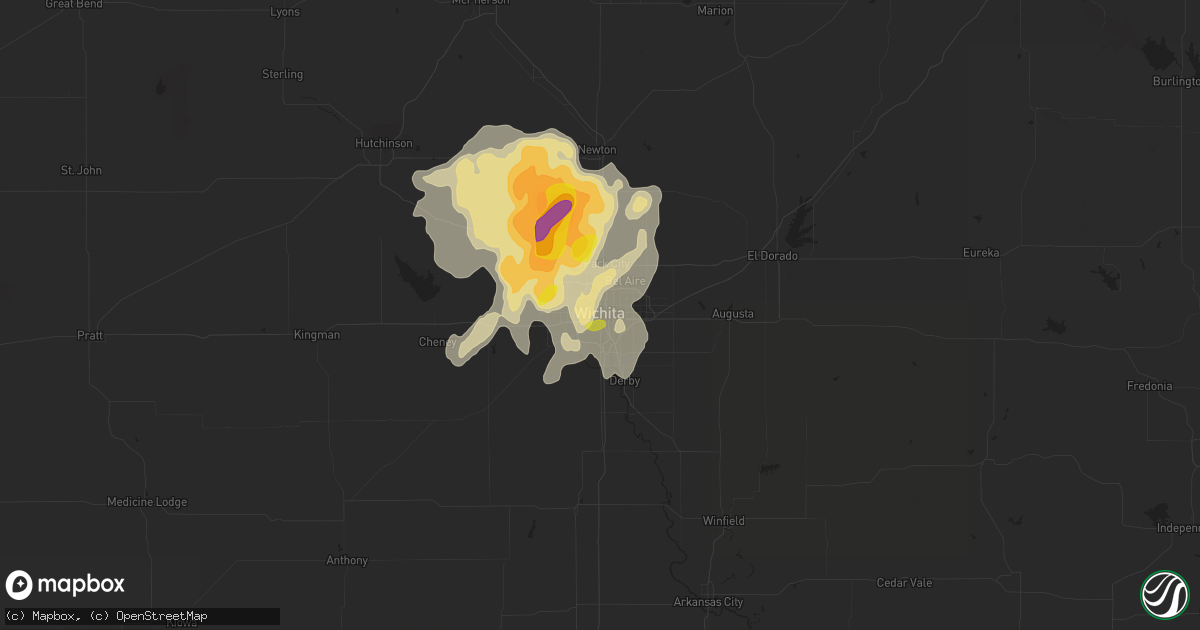
Hail Map in Wichita, KS on June 15, 2016
Get this storm
June 15 map
$229
one time, instant access
Download today. No call, no setup
Keep the $229
Bought the map and want the full workflow? Apply the entire $229 to a subscription within 7 days. None of it is wasted.
Every map, not just this one
This buys you this map. Subscription and you get every map we run, in the markets you choose from a few cities to whole states to nationwide. Plus real-time alerts the moment a storm fires.
Contact data
Name, contact info, occupancy, even credit band for addresses in the footprint. You go from where it hit to who to call.
Become the source they trust
Unlimited branding weather history reports on demand. You already have the documented answer ready for the property owner, and you are the one who showed up with it.
Property data and RoofTrace estimates
Pull up any address you have got, its value and the exact code rules for that jurisdiction, straight from One Click Code. Then RoofTrace estimates the squares, pitch, and roof value, priced the way you price.
Storm reports in Wichita, KS
Wichita, KS
| Date | Description |
|---|---|
| 06/15/20164:53 PM CDT | Viewer report to kwch of nickel to quarter sized hail in riverside. |
| 06/15/20164:42 PM CDT | Public report via twitter of dime to quarter sized hail at lincoln and broadway. |
| 06/14/20169:45 PM CDT | Retired nws employee reports 60 mph winds. |
| 06/14/20169:33 PM CDT | A local report indicates 60 MPH wind near JABARA AIRPORT |
| 06/14/20167:01 PM CDT | Nws employee reports quarter sized hail which has lasted for the last 2 minutes at 21st and 119th. |
All States Impacted by Hail Map on June 15, 2016
All Cities Impacted by Hail Map on June 15, 2016
- Fort Peck, MT
- Wolf Point, MT
- Brusett, MT
- Stafford, KS
- St John, KS
- Greenup, IL
- Hidalgo, IL
- Jewett, IL
- Delphos, KS
- Minneapolis, KS
- Glasco, KS
- Nashua, MT
- Benton, KS
- Ripley, TN
- Lorraine, KS
- Dorrance, KS
- Wilson, KS
- Holyrood, KS
- Lubbock, TX
- Levelland, TX
- Shallowater, TX
- Quitaque, TX
- Berryton, KS
- Topeka, KS
- Little River, KS
- Lyons, KS
- Ottawa, KS
- Benton, KY
- Gilbertsville, KY
- Inman, KS
- Hutchinson, KS
- Mcpherson, KS
- Galva, KS
- Hale Center, TX
- Williston, ND
- Saline, MI
- Milan, MI
- Moundridge, KS
- Newton, KS
- Goessel, KS
- Lockney, TX
- Silverton, TX
- Mendon, MI
- Cottage Grove, TN
- Paris, TN
- Lindsborg, KS
- Antelope, MT
- Medicine Lake, MT
- Reserve, MT
- Robinson, IL
- Plato, MO
- Hemingway, SC
- Georgetown, SC
- Julian, WV
- Ridgeview, WV
- Fayette, AL
- Jordan, MT
- Oostburg, WI
- Sheboygan Falls, WI
- Sheboygan, WI
- Millington, TN
- Houston, MO
- Bucyrus, MO
- Elmdale, KS
- Marion, KS
- Cedar Point, KS
- Iron City, TN
- Cypress Inn, TN
- Midland, TX
- Andale, KS
- Wichita, KS
- Goddard, KS
- Cheney, KS
- Garden Plain, KS
- Burrton, KS
- Kechi, KS
- Colwich, KS
- Valley Center, KS
- Mount Hope, KS
- Maize, KS
- Halstead, KS
- Bentley, KS
- Haven, KS
- Sedgwick, KS
- Elba, NE
- Greeley, NE
- Scotia, NE
- Madison, KS
- Nova, OH
- Greenwich, OH
- New London, OH
- Hayti, MO
- Bragg City, MO
- Wardell, MO
- Circle, MT
- Blytheville, AR
- Roachdale, IN
- Russellville, IN
- Rockville, IN
- Greencastle, IN
- North Salem, IN
- Danville, IN
- Ladoga, IN
- Bainbridge, IN
- Salina, KS
- New Cambria, KS
- West Point, KY
- Laconia, IN
- Fort Knox, KY
- Muldraugh, KY
- Ekron, KY
- Brandenburg, KY
- Martin, MI
- Shelbyville, MI
- Kenmare, ND
- Westport, TN
- Holladay, TN
- Friendship, WI
- Arkdale, WI
- Brookville, KS
- Mentone, TX
- Pocahontas, AR
- Black Rock, AR
- Marshall, IL
- Martinsville, IL
- Springfield, OH
- New Carlisle, OH
- Brockton, MT
- Fort Davis, TX
- Tower Hill, IL
- Ranger, WV
- Spurlockville, WV
- Pyote, TX
- Wink, TX
- Monahans, TX
- Barstow, TX
- Ridgeway, VA
- Axton, VA
- Grafton, WI
- Mequon, WI
- Milwaukee, WI
- Amherst, OH
- Vermilion, OH
- Smithville, AR
- Conway, SC
- Aynor, SC
- Owensboro, KY
- Tulia, TX
- Clyde, KS
- Concordia, KS
- Westfield, WI
- Coloma, WI
- Jackson, WI
- Germantown, WI
- Cedarburg, WI
- West Bend, WI
- Jonesboro, AR
- Bay, AR
- Beech Grove, AR
- Paragould, AR
- Clarendon, TX
- Hilbert, WI
- Chilton, WI
- Pangburn, AR
- Bicknell, IN
- Oaktown, IN
- Bruceville, IN
- North Ridgeville, OH
- North Olmsted, OH
- Olmsted Falls, OH
- Columbia City, IN
- Logan, OH
- Barlow, KY
- Union City, TN
- Columbus, KY
- Tiptonville, TN
- Water Valley, KY
- Arlington, KY
- Bardwell, KY
- Kevil, KY
- Paducah, KY
- Melber, KY
- Charleston, MO
- Obion, TN
- Cunningham, KY
- Portageville, MO
- La Center, KY
- Wickliffe, KY
- Hickman, KY
- Ridgely, TN
- Rives, TN
- Hickory, KY
- Mayfield, KY
- Wingo, KY
- Boaz, KY
- Troy, TN
- Martin, TN
- East Prairie, MO
- West Paducah, KY
- Hornbeak, TN
- Kenton, TN
- Fancy Farm, KY
- Fulton, KY
- Clinton, KY
- Solomon, KS
- Waldo, KS
- Luray, KS
- Osborne, KS
- Seminole, TX
- Lucas, KS
- Sylvan Grove, KS
- Elkton, KY
- Gypsum, KS
- Raymond, KS
- Tuscumbia, AL
- Muscle Shoals, AL
- Fremont, WI
- Windom, KS
- Geneseo, KS
- Bushton, KS
- Ellsworth, KS
- Kanopolis, KS
- Mankato, KS
- Burr Oak, KS
- Indianapolis, IN
- Sand Springs, MT
- Mosby, MT
- Salt Flat, TX
- Van Horn, TX
- Jewell, KS
- Viola, KS
- Calico Rock, AR
- Melbourne, AR
- Winnett, MT
- Hardy, AR
- Williford, AR
- Andrews, TX
- Markleville, IN
- Shirley, IN
- Wilkinson, IN
- Wellington, OH
- Henderson, KY
- Hartselle, AL
- Decatur, AL
- Olton, TX
- Whiteface, TX
- Cheraw, SC
- Nekoosa, WI
- Necedah, WI
- Greenup, KY
- Centreville, MI
- Eureka, KS
- Powers Lake, ND
- Merrillan, WI
- Black River Falls, WI
- Pittsville, WI
- Bloomfield, IN
- Selmer, TN
- Michie, TN
- Stantonville, TN
- Fairmont, NC
- Alkol, WV
- Powell, OH
- Kingman, KS
- Twelve Mile, IN
- Mount Vernon, IN
- Hutsonville, IL
- Wakeman, OH
- Bunker Hill, KS
- Adamsville, TN
- Bethel Springs, TN
- Montrose, IL
- Newton, IL
- Wheeler, IL
- Lovington, NM
- Paradise, KS
- Memphis, TN
- Golden, MS
- Campbell, NE
- Rhinelander, WI
- Crawfordsville, IN
- Poplar, MT
- Fort Stockton, TX
- Myrtle Beach, SC
- Lynnville, IN
- Boonville, IN
- Aurora, KS
- Miltonvale, KS
- Merom, IN
- Carlisle, IN
- Dugger, IN
- Sullivan, IN
- Grand Junction, MI
- Berry, AL
- Carbon Hill, AL
- Plainview, TX
- Elizabeth, IN
- North Fairfield, OH
- Palmer, KS
- Clifton, KS
- Linn, KS
- Tampa, KS
- Yellow Springs, OH
- Dagmar, MT
- Grand Rivers, KY
- Calvert City, KY
- Jal, NM
- Mount Gilead, OH
- Mansfield, OH
- Galion, OH
- Olivehill, TN
- Bangor, MI
- Palestine, IL
- Arthur, IL
- Hepler, KS
- Savonburg, KS
- Uniontown, KS
- Paris, IL
- Brocton, IL
- Frazer, MT
- Wakarusa, KS
- Littlefield, TX
- Rose Hill, KS
- Benton, IL
- Ina, IL
- Whittington, IL
- Big Spring, TX
- Rosedale, IN
- Brazil, IN
- Terre Haute, IN
- Solsberry, IN
- Bath Springs, TN
- Decaturville, TN
- Denver City, TX
- Walnut Ridge, AR
- Marmaduke, AR
- Gainesville, MO
- North Royalton, OH
- Hinckley, OH
- Poplar Bluff, MO
- Coden, AL
- Coopersville, MI
- Ravenna, MI
- Fisk, MO
- New London, WI
- Sedalia, KY
- Zionsville, IN
- Peabody, KS
- Walton, KS
- West Liberty, IL
- Willow Hill, IL
- Oblong, IL
- Udall, KS
- Viola, AR
- Gepp, AR
- Lawrenceburg, TN
- Westpoint, TN
- Loretto, TN
- Pecos, TX
- Saint Paul, NE
- Dannebrog, NE
- Collinwood, TN
- Murrells Inlet, SC
- Homestead, MT
- Americus, KS
- Goodlettsville, TN
- Falun, KS
- Pleasant Plains, AR
- Batesville, AR
- Floral, AR
- Ypsilanti, MI
- Campbellsburg, IN
- Orleans, IN
- Camp Dennison, OH
- Milford, OH
- Cincinnati, OH
- Ewing, IL
- Scheller, IL
- Bonnie, IL
- Waltonville, IL
- Parsons, TN
- Sugar Tree, TN
- Middletown, IN
- Springport, IN
- Maple Hill, KS
- Harveyville, KS
- Kress, TX
- Manawa, WI
- Jackson, MI
- Coal City, WV
- Rhodell, WV
- Princewick, WV
- Josephine, WV
- Swansboro, NC
- Stella, NC
- Arab, AL
- Chanute, KS
- Wilsondale, WV
- Breeden, WV
- Kermit, WV
- Weyauwega, WI
- Eva, AL
- Falkville, AL
- Anton, TX
- Hope, KS
- Bowling Green, KY
- Alvaton, KY
- Malta, MT
- Hindsboro, IL
- Markesan, WI
- Owosso, MI
- Baldwin City, KS
- Paola, KS
- Wellsville, KS
- Palm Coast, FL
- Courtland, AL
- Hillsboro, AL
- Franklin, IN
- Bloomingdale, MI
- Paw Paw, MI
- South Haven, MI
- Brownsburg, IN
- Murray, KY
- Lehigh, KS
- Canton, KS
- Hillsboro, KS
- Lyons, IN
- Plainville, IN
- Odon, IN
- Sandborn, IN
- Elnora, IN
- Adairville, KY
- Springfield, TN
- Cedar Hill, TN
- Olmstead, KY
- Sulphur Rock, AR
- Newark, AR
- Charlotte, AR
- Lawrence, MI
- Lawton, MI
- Linden, TN
- Turkey, TX
- Akron, OH
- Cuyahoga Falls, OH
- Hortonville, WI
- Trumann, AR
- Lewis Center, OH
- Columbus, OH
- Westerville, OH
- Artesia, NM
- Newton, WI
- Princeton, IN
- Decker, IN
- Allendale, IL
- Fort Branch, IN
- Owensville, IN
- Patoka, IN
- Russell, KS
- Noonan, ND
- Newberry, IN
- Scotland, IN
- Claremont, IL
- Olney, IL
- Normandy, TN
- Savannah, TN
- Decatur, MI
- Lerna, IL
- Charleston, IL
- Carbon, IN
- Orrum, NC
- Murdock, KS
- Brandon, WI
- Waupun, WI
- Marquette, KS
- Belle Plaine, KS
- Fort Scott, KS
- Mount Pleasant, AR
- Strawberry, AR
- Poughkeepsie, AR
- Cord, AR
- Desha, AR
- Cave City, AR
- Sidney, AR
- Morganville, KS
- Brownsville, TN
- Henning, TN
- Greenfield, IN
- Imperial, TX
- Coyanosa, TX
- Collins, WI
- Reedsville, WI
- Muncie, IN
- Elizabethtown, IL
- Montello, WI
- Warrens, WI
- Babcock, WI
- Grand Marsh, WI
- Waynesboro, TN
- Casey, IL
- Toledo, IL
- Uniontown, KY
- Waverly, KY
- Morganfield, KY
- Harviell, MO
- Belleville, MI
- Newport, MI
- Carleton, MI
- New Boston, MI
- Crane Hill, AL
- Bremen, AL
- Teutopolis, IL
- Sigel, IL
- Effingham, IL
- Fort Wayne, IN
- Whitewater, KS
- West Union, IL
- Saukville, WI
- Kewaskum, WI
- Fredonia, WI
- Allenton, WI
- Theresa, WI
- Town Creek, AL
- Washington, IN
- Edwardsport, IN
- Montgomery, IN
- Loogootee, IN
- Westphalia, IN
- Fisher, AR
- Abilene, KS
- Assaria, KS
- Durham, KS
- Villa Ridge, IL
- Alamo, ND
- Saffell, AR
- Murphysboro, IL
- Spivey, KS
- Isabella, MO
- Theodosia, MO
- Trinity, AL
- Moulton, AL
- Pendleton, IN
- Three Rivers, MI
- Colon, MI
- Ashmore, IL
- Westfield, IL
- Hamilton, OH
- Caraway, AR
- Lyndon, KS
- Scranton, KS
- Sullivan, IL
- Fremont, IN
- Coldwater, MI
- Camden, TN
- Bruceton, TN
- Glen Elder, KS
- Odessa, TX
- Hampstead, NC
- Holly Ridge, NC
- Sneads Ferry, NC
- Eden, NC
- Cascade, VA
- Bremen, KS
- Peru, IN
- Mansfield, TN
- Bells, TN
- New Ross, IN
- Hobbs, NM
- Merrill, WI
- Bankston, AL
- Allegan, MI
- Newbern, TN
- Trimble, TN
- Stewardson, IL
- Shelbyville, IL
- Lakewood, IL
- Happy, TX
- Burlingame, KS
- Garnett, KS
- Lawrence, KS
- Overbrook, KS
- Bradford, OH
- New Weston, OH
- Rossburg, OH
- Saint Henry, OH
- Versailles, OH
- Burkettsville, OH
- Fort Recovery, OH
- Olpe, KS
- Humboldt, KS
- Neenah, WI
- Larsen, WI
- Appleton, WI
- Anderson, AL
- Rogersville, AL
- Lexington, AL
- Stanton, TX
- Bargersville, IN
- Mount Vernon, OH
- Fredericktown, OH
- Vida, MT
- Lakeview, TX
- Redfield, KS
- Elsmore, KS
- West Terre Haute, IN
- Lancaster, OH
- Haleyville, AL
- New Orleans, LA
- Dukedom, TN
- Palmersville, TN
- Lebanon, IN
- Ostrander, OH
- Delaware, OH
- Plain City, OH
- Marysville, OH
- Dora, AL
- Empire, AL
- Plymouth, WI
- Waldo, WI
- Grandfalls, TX
- Kermit, TX
- Newman, IL
- Cleveland, WI
- Arley, AL
- Addison, AL
- Cullman, AL
- Arcola, IL
- Zortman, MT
- Ropesville, TX
- Meadow, TX
- Fortuna, ND
- Rose Bud, AR
- Heber Springs, AR
- Yates Center, KS
- Piqua, KS
- Dyersburg, TN
- Dunlow, WV
- Kiahsville, WV
- Harts, WV
- Mexico, IN
- Kennard, IN
- New Castle, IN
- Spiceland, IN
- Knightstown, IN
- Thorntown, IN
- Hanceville, AL
- Williamsburg, KS
- Dresden, TN
- Gleason, TN
- Pomona, KS
- Elberfeld, IN
- Oakland City, IN
- Auburn, KS
- Shelby, MI
- McKenzie, TN
- Hollow Rock, TN
- Huntingdon, TN
- Killen, AL
- Moran, KS
- Bowbells, ND
- Ray, ND
- Delton, MI
- Hickory Corners, MI
- Port Washington, WI
- Battle Creek, MI
- East Leroy, MI
- Ceresco, MI
- Dongola, IL
- Howe, IN
- Pleasant Lake, IN
- Hamilton, IN
- Edon, OH
- Angola, IN
- Orland, IN
- Bolivia, NC
- Kirksey, KY
- Hartford, MI
- Covert, MI
- Schoolcraft, MI
- Whitestown, IN
- Advance, IN
- Jamestown, IN
- Shelburn, IN
- Fairbanks, IN
- Vincennes, IN
- Fairfield, OH
- Grenora, ND
- Crane, TX
- Somerville, TN
- Arlington, TN
- Utica, KY
- Calhoun, KY
- Sheridan, IN
- Bronson, MI
- Mcconnell Afb, KS
- Muskegon, MI
- Dennison, IL
- Augusta, MI
- Hardenville, MO
- Brookport, IL
- Glasgow, KY
- Rockbridge, OH
- West Olive, MI
- Hardin, KY
- Hamilton, KS
- Scandia, KS
- Bladen, NE
- Napoleon, MI
- Norvell, MI
- Grass Lake, MI
- Brooklyn, MI
- Marcellus, MI
- Cassopolis, MI
- Camdenton, MO
- Strong City, KS
- Madison, IN
- Danville, AL
- Stanley, ND
- Pawleys Island, SC
- Milton, KY
- Plentywood, MT
- Nichols, SC
- Lake View, SC
- Derby, KS
- Falcon, MO
- Monroeville, OH
- West Salem, OH
- Norwalk, OH
- Willard, OH
- Ashland, OH
- Sullivan, OH
- Almo, KY
- Dexter, KY
- Red Bay, AL
- Grand Junction, TN
- Malden, MO
- Campbell, MO
- Lizton, IN
- Darlington, IN
- Westfield, IN
- Avon, IN
- Pittsboro, IN
- Carmel, IN
- Griffithsville, WV
- Yawkey, WV
- New Haven, IL
- Carmi, IL
- Norris City, IL
- Imboden, AR
- Bellville, OH
- Gambier, OH
- Plains, TX
- Chrisman, IL
- Milladore, WI
- Junction City, WI
- Cave In Rock, IL
- Anna, IL
- Eastover, SC
- Bolivar, TN
- Maben, WV
- Shelbyville, IN
- Linton, IN
- Council Grove, KS
- Plainwell, MI
- Wellington, KS
- Peck, KS
- Menasha, WI
- Henderson, TN
- Cherokee Village, AR
- Evening Shade, AR
- Stanton, TN
- Golconda, IL
- Clinton, IN
- Mecca, IN
- Montezuma, IN
- Louisville, KY
- Kansas, IL
- Trilla, IL
- Gays, IL
- Mattoon, IL
- Neoga, IL
- Newport, NC
- Sherwood, WI
- Beaumont, KS
- Leon, KS
- Trenton, OH
- Glenbeulah, WI
- Saint Cloud, WI
- Mount Calvary, WI
- Metropolis, IL
- Pretty Prairie, KS
- Marshall, IN
- Loving, NM
- Richmond, KS
- Florence, KS
- Nimitz, WV
- Jumping Branch, WV
- New Harmony, IN
- Wadesville, IN
- Claflin, KS
- Ash Flat, AR
- Vicksburg, MI
- Scotts, MI
- Welda, KS
- Symsonia, KY
- Ledbetter, KY
- Smithland, KY
- Henry, TN
- Ney, OH
- Defiance, OH
- Bryan, OH
- Gobles, MI
- Corinth, MS
- Shawneetown, IL
- Broughton, IL
- East Lynn, WV
- Branchland, WV
- Greenway, AR
- Lawrenceville, IL
- Brookland, AR
- Hackleburg, AL
- Kingman, IN
- South Fulton, TN
- Humboldt, IL
- Hesston, KS
- Spottsville, KY
- Daytona Beach, FL
- Port Orange, FL
- Peerless, MT
- Tyronza, AR
- Brockwell, AR
- Pineville, AR
- Wideman, AR
- Hanover, KS
- Crosby, ND
- Manchester, MI
- Piggott, AR
- Decatur, IN
- Hoagland, IN
- Spring Hill, KS
- Gardner, KS
- Oketo, KS
- Smithville, OH
- Stevens Point, WI
- Broseley, MO
- Strongsville, OH
- Vinemont, AL
- Kalamazoo, MI
- Pullman, MI
- Mattawan, MI
- Leonidas, MI
- Sherwood, MI
- Manitowoc, WI
- Spencer, IN
- Freedom, IN
- Broadview Heights, OH
- Cherry Valley, AR
- Harrisburg, AR
- Noblesville, IN
- Wolfforth, TX
- Tipton, KS
- Downs, KS
- Spencer, OH
- Wheatland, IN
- Kiel, WI
- Oakland, IL
- Mounds, IL
- Hopkins, MI
- Edgerton, KS
- Carbondale, KS
- Whiteville, TN
- Tolley, ND
- Columbia Station, OH
- Berea, OH
- Cleveland, OH
- Brillion, WI
- Lynchburg, MO
- Grand Island, NE
- Spring Lake, MI
- Grand Haven, MI
- Marked Tree, AR
- Brownfield, TX
- Reedsville, OH
- Weiner, AR
- Coker, AL
- Northport, AL
- Adams, TN
- Allensville, KY
- Utica, OH
- Lake City, AR
- Milton, IN
- Somerville, AL
- El Dorado, KS
- Warsaw, OH
- Walhonding, OH
- Otsego, MI
- Michigan City, MS
- Lynn, AR
- Cordova, TN
- Wartrace, TN
- Matador, TX
- Lomira, WI
- Mayville, WI
- Brownsville, WI
- Amanda, OH
- Ashley, IL
- Reelsville, IN
- Cloverdale, IN
- Greenwich, KS
- Clearwater, KS
- Haysville, KS
- Sterling, KS
- Eldorado, IL
- Smyer, TX
- Richland, IN
- Union Grove, AL
- Constantine, MI
- Montpelier, OH
- Edgerton, OH
- Sturgis, MI
- Burr Oak, MI
- Byron Center, MI
- Hamilton, MI
- Dorr, MI
- Zeeland, MI
- Holland, MI
- Knott, TX
- Willis, MI
- Clay, KY
- Wingate, IN
- New Richmond, IN
- New Straitsville, OH
- Mount Hope, AL
- Bottineau, ND
- Greenfield, TN
- Cobden, IL
- Wayne, WV
- Lafe, AR


