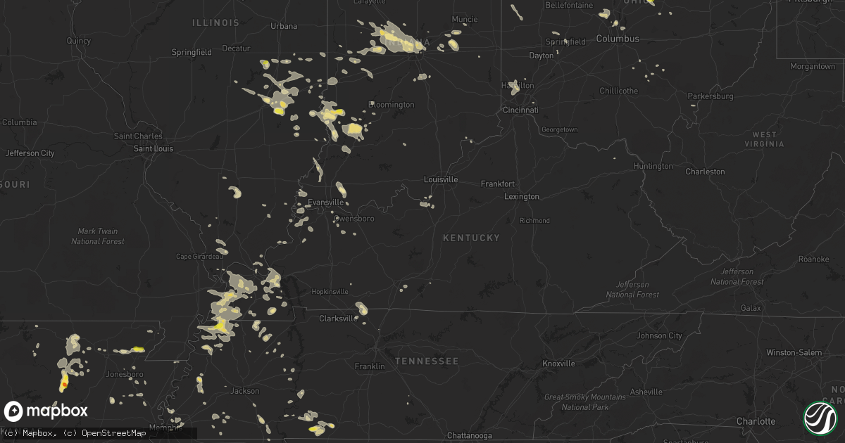
Hail Map in Kentucky on June 15, 2016
Get this storm
June 15 map
$229
one time, instant access
Download today. No call, no setup
Keep the $229
Bought the map and want the full workflow? Apply the entire $229 to a subscription within 7 days. None of it is wasted.
Every map, not just this one
This buys you this map. Subscription and you get every map we run, in the markets you choose from a few cities to whole states to nationwide. Plus real-time alerts the moment a storm fires.
Contact data
Name, contact info, occupancy, even credit band for addresses in the footprint. You go from where it hit to who to call.
Become the source they trust
Unlimited branding weather history reports on demand. You already have the documented answer ready for the property owner, and you are the one who showed up with it.
Property data and RoofTrace estimates
Pull up any address you have got, its value and the exact code rules for that jurisdiction, straight from One Click Code. Then RoofTrace estimates the squares, pitch, and roof value, priced the way you price.
Storm reports in Kentucky
Kentucky
| Date | Description |
|---|---|
| 06/15/20166:56 PM CDT | Trees downed. |
| 06/15/20166:34 PM CDT | A local report indicates 60 MPH wind near 1 NW CRITTENDEN |
| 06/15/20166:20 PM CDT | Large tree branch down. Time estimated by radar. |
| 06/15/20165:34 PM CDT | 6 to 10 inch branches were torn from several trees on the south side of town. |
| 06/15/20163:54 PM CDT | Trees and power lines down at sportsman lake road and at akin avenue. |
| 06/15/20163:48 PM CDT | Tree down on henry clay smith rd. |
| 06/15/20163:40 PM CDT | Tree down. |
| 06/15/20163:38 PM CDT | Downed power lines blocking audubon drive. |
| 06/15/20163:28 PM CDT | Downed tree on a car. |
| 06/15/20163:25 PM CDT | Tree down. |
| 06/15/20163:20 PM CDT | Power outages reported throughout the community |
| 06/15/20163:15 PM CDT | Trees down in pembroke and hopkinsville. Power outages reported in both communities. |
| 06/15/20163:14 PM CDT | Tree down across road. |
| 06/15/20163:10 PM CDT | Trees uprooted in morgantown. |
| 06/15/20163:07 PM CDT | Several trees down in morgantown. |
| 06/15/20162:55 PM CDT | Winds estimated |
| 06/15/20162:50 PM CDT | Late report - power lines down near greenville |
| 06/15/20162:46 PM CDT | Trees down. |
| 06/15/20162:45 PM CDT | Late report - tree down in drakesboro |
| 06/15/20162:45 PM CDT | Several trees down around the fulton area along hwy 307 and also near the purchase parkway. |
| 06/15/20162:45 PM CDT | Tree down along south road. |
| 06/15/20162:39 PM CDT | Several trees down on highway 69 and at hoopie hill road. |
| 06/15/20162:35 PM CDT | Tree down along linton road. Lost all of the traffic barrels on the new barkley bridge project. |
| 06/15/20162:15 PM CDT | Trees down and snapped along the fort leasure trail. |
| 06/15/20162:15 PM CDT | Late report. Numerous trees down. Corn laid over. One tree fell across a home but no injuries reported. Most damage reported along sarten road and hwy 51 south. |
| 06/15/20162:10 PM CDT | Wind estimated. Pea size hail reported with this storm. |
| 06/15/20162:10 PM CDT | Downed tree blocking manslick road. |
| 06/15/20162:05 PM CDT | Tree down at intersection of 4th and olive. |
| 06/15/20162:00 PM CDT | 3 foot diameter tree snapped. |
| 06/15/20162:00 PM CDT | Late report. Trees down along hwy 641 just south of benton and along oak level road near the marshall/graves county line. Structural damage to barns and trees down at 4 |
| 06/15/20161:59 PM CDT | Em reports numerous trees down along roadways. Heavy rain and strong winds reported with storms. |
| 06/15/20161:50 PM CDT | Late report. Trees down along hwy 136. |
| 06/15/20161:45 PM CDT | Several trees down on west side of county. Also a large tree limb down on east side of owensboro. |
| 06/15/20161:45 PM CDT | Trees down. Minor roof damage. Power lines down as well. Time estimated. |
| 06/15/20161:35 PM CDT | *** 1 fatal *** late report - a 56 year old man was killed near the beginning of the microburst damage path as a result of fallen trees as he travelled along hwy 534 in |
| 06/15/20161:23 PM CDT | Trees snapped and uprooted along hwy 62 in 3 locations. Fire rescue and law enforcement are responding. |
| 06/14/20168:50 PM CDT | Large limbs down on clay lick road. |
| 06/14/20168:43 PM CDT | 30 to 40 ft. Tree down |
| 06/14/20168:32 PM CDT | Tree down blocking stoney run rd. At phelps rd. Time estimated based on radar. |
| 06/14/20168:08 PM CDT | Several downed trees across clark county blocking roads. |
| 06/14/20168:05 PM CDT | Several power lines down across the county. |
| 06/14/20167:29 PM CDT | Downed tree on a house at 104 first street and a tree blocking the road. |
All States Impacted by Hail Map on June 15, 2016
Cities Impacted by Hail Map on June 15, 2016
- Fort Peck, MT
- Wolf Point, MT
- Brusett, MT
- Stafford, KS
- St John, KS
- Greenup, IL
- Hidalgo, IL
- Jewett, IL
- Delphos, KS
- Minneapolis, KS
- Glasco, KS
- Nashua, MT
- Benton, KS
- Ripley, TN
- Lorraine, KS
- Dorrance, KS
- Wilson, KS
- Holyrood, KS
- Lubbock, TX
- Levelland, TX
- Shallowater, TX
- Quitaque, TX
- Berryton, KS
- Topeka, KS
- Little River, KS
- Lyons, KS
- Ottawa, KS
- Benton, KY
- Gilbertsville, KY
- Inman, KS
- Hutchinson, KS
- Mcpherson, KS
- Galva, KS
- Hale Center, TX
- Williston, ND
- Saline, MI
- Milan, MI
- Moundridge, KS
- Newton, KS
- Goessel, KS
- Lockney, TX
- Silverton, TX
- Mendon, MI
- Cottage Grove, TN
- Paris, TN
- Lindsborg, KS
- Antelope, MT
- Medicine Lake, MT
- Reserve, MT
- Robinson, IL
- Plato, MO
- Hemingway, SC
- Georgetown, SC
- Julian, WV
- Ridgeview, WV
- Fayette, AL
- Jordan, MT
- Oostburg, WI
- Sheboygan Falls, WI
- Sheboygan, WI
- Millington, TN
- Houston, MO
- Bucyrus, MO
- Elmdale, KS
- Marion, KS
- Cedar Point, KS
- Iron City, TN
- Cypress Inn, TN
- Midland, TX
- Andale, KS
- Wichita, KS
- Goddard, KS
- Cheney, KS
- Garden Plain, KS
- Burrton, KS
- Kechi, KS
- Colwich, KS
- Valley Center, KS
- Mount Hope, KS
- Maize, KS
- Halstead, KS
- Bentley, KS
- Haven, KS
- Sedgwick, KS
- Elba, NE
- Greeley, NE
- Scotia, NE
- Madison, KS
- Nova, OH
- Greenwich, OH
- New London, OH
- Hayti, MO
- Bragg City, MO
- Wardell, MO
- Circle, MT
- Blytheville, AR
- Roachdale, IN
- Russellville, IN
- Rockville, IN
- Greencastle, IN
- North Salem, IN
- Danville, IN
- Ladoga, IN
- Bainbridge, IN
- Salina, KS
- New Cambria, KS
- West Point, KY
- Laconia, IN
- Fort Knox, KY
- Muldraugh, KY
- Ekron, KY
- Brandenburg, KY
- Martin, MI
- Shelbyville, MI
- Kenmare, ND
- Westport, TN
- Holladay, TN
- Friendship, WI
- Arkdale, WI
- Brookville, KS
- Mentone, TX
- Pocahontas, AR
- Black Rock, AR
- Marshall, IL
- Martinsville, IL
- Springfield, OH
- New Carlisle, OH
- Brockton, MT
- Fort Davis, TX
- Tower Hill, IL
- Ranger, WV
- Spurlockville, WV
- Pyote, TX
- Wink, TX
- Monahans, TX
- Barstow, TX
- Ridgeway, VA
- Axton, VA
- Grafton, WI
- Mequon, WI
- Milwaukee, WI
- Amherst, OH
- Vermilion, OH
- Smithville, AR
- Conway, SC
- Aynor, SC
- Owensboro, KY
- Tulia, TX
- Clyde, KS
- Concordia, KS
- Westfield, WI
- Coloma, WI
- Jackson, WI
- Germantown, WI
- Cedarburg, WI
- West Bend, WI
- Jonesboro, AR
- Bay, AR
- Beech Grove, AR
- Paragould, AR
- Clarendon, TX
- Hilbert, WI
- Chilton, WI
- Pangburn, AR
- Bicknell, IN
- Oaktown, IN
- Bruceville, IN
- North Ridgeville, OH
- North Olmsted, OH
- Olmsted Falls, OH
- Columbia City, IN
- Logan, OH
- Barlow, KY
- Union City, TN
- Columbus, KY
- Tiptonville, TN
- Water Valley, KY
- Arlington, KY
- Bardwell, KY
- Kevil, KY
- Paducah, KY
- Melber, KY
- Charleston, MO
- Obion, TN
- Cunningham, KY
- Portageville, MO
- La Center, KY
- Wickliffe, KY
- Hickman, KY
- Ridgely, TN
- Rives, TN
- Hickory, KY
- Mayfield, KY
- Wingo, KY
- Boaz, KY
- Troy, TN
- Martin, TN
- East Prairie, MO
- West Paducah, KY
- Hornbeak, TN
- Kenton, TN
- Fancy Farm, KY
- Fulton, KY
- Clinton, KY
- Solomon, KS
- Waldo, KS
- Luray, KS
- Osborne, KS
- Seminole, TX
- Lucas, KS
- Sylvan Grove, KS
- Elkton, KY
- Gypsum, KS
- Raymond, KS
- Tuscumbia, AL
- Muscle Shoals, AL
- Fremont, WI
- Windom, KS
- Geneseo, KS
- Bushton, KS
- Ellsworth, KS
- Kanopolis, KS
- Mankato, KS
- Burr Oak, KS
- Indianapolis, IN
- Sand Springs, MT
- Mosby, MT
- Salt Flat, TX
- Van Horn, TX
- Jewell, KS
- Viola, KS
- Calico Rock, AR
- Melbourne, AR
- Winnett, MT
- Hardy, AR
- Williford, AR
- Andrews, TX
- Markleville, IN
- Shirley, IN
- Wilkinson, IN
- Wellington, OH
- Henderson, KY
- Hartselle, AL
- Decatur, AL
- Olton, TX
- Whiteface, TX
- Cheraw, SC
- Nekoosa, WI
- Necedah, WI
- Greenup, KY
- Centreville, MI
- Eureka, KS
- Powers Lake, ND
- Merrillan, WI
- Black River Falls, WI
- Pittsville, WI
- Bloomfield, IN
- Selmer, TN
- Michie, TN
- Stantonville, TN
- Fairmont, NC
- Alkol, WV
- Powell, OH
- Kingman, KS
- Twelve Mile, IN
- Mount Vernon, IN
- Hutsonville, IL
- Wakeman, OH
- Bunker Hill, KS
- Adamsville, TN
- Bethel Springs, TN
- Montrose, IL
- Newton, IL
- Wheeler, IL
- Lovington, NM
- Paradise, KS
- Memphis, TN
- Golden, MS
- Campbell, NE
- Rhinelander, WI
- Crawfordsville, IN
- Poplar, MT
- Fort Stockton, TX
- Myrtle Beach, SC
- Lynnville, IN
- Boonville, IN
- Aurora, KS
- Miltonvale, KS
- Merom, IN
- Carlisle, IN
- Dugger, IN
- Sullivan, IN
- Grand Junction, MI
- Berry, AL
- Carbon Hill, AL
- Plainview, TX
- Elizabeth, IN
- North Fairfield, OH
- Palmer, KS
- Clifton, KS
- Linn, KS
- Tampa, KS
- Yellow Springs, OH
- Dagmar, MT
- Grand Rivers, KY
- Calvert City, KY
- Jal, NM
- Mount Gilead, OH
- Mansfield, OH
- Galion, OH
- Olivehill, TN
- Bangor, MI
- Palestine, IL
- Arthur, IL
- Hepler, KS
- Savonburg, KS
- Uniontown, KS
- Paris, IL
- Brocton, IL
- Frazer, MT
- Wakarusa, KS
- Littlefield, TX
- Rose Hill, KS
- Benton, IL
- Ina, IL
- Whittington, IL
- Big Spring, TX
- Rosedale, IN
- Brazil, IN
- Terre Haute, IN
- Solsberry, IN
- Bath Springs, TN
- Decaturville, TN
- Denver City, TX
- Walnut Ridge, AR
- Marmaduke, AR
- Gainesville, MO
- North Royalton, OH
- Hinckley, OH
- Poplar Bluff, MO
- Coden, AL
- Coopersville, MI
- Ravenna, MI
- Fisk, MO
- New London, WI
- Sedalia, KY
- Zionsville, IN
- Peabody, KS
- Walton, KS
- West Liberty, IL
- Willow Hill, IL
- Oblong, IL
- Udall, KS
- Viola, AR
- Gepp, AR
- Lawrenceburg, TN
- Westpoint, TN
- Loretto, TN
- Pecos, TX
- Saint Paul, NE
- Dannebrog, NE
- Collinwood, TN
- Murrells Inlet, SC
- Homestead, MT
- Americus, KS
- Goodlettsville, TN
- Falun, KS
- Pleasant Plains, AR
- Batesville, AR
- Floral, AR
- Ypsilanti, MI
- Campbellsburg, IN
- Orleans, IN
- Camp Dennison, OH
- Milford, OH
- Cincinnati, OH
- Ewing, IL
- Scheller, IL
- Bonnie, IL
- Waltonville, IL
- Parsons, TN
- Sugar Tree, TN
- Middletown, IN
- Springport, IN
- Maple Hill, KS
- Harveyville, KS
- Kress, TX
- Manawa, WI
- Jackson, MI
- Coal City, WV
- Rhodell, WV
- Princewick, WV
- Josephine, WV
- Swansboro, NC
- Stella, NC
- Arab, AL
- Chanute, KS
- Wilsondale, WV
- Breeden, WV
- Kermit, WV
- Weyauwega, WI
- Eva, AL
- Falkville, AL
- Anton, TX
- Hope, KS
- Bowling Green, KY
- Alvaton, KY
- Malta, MT
- Hindsboro, IL
- Markesan, WI
- Owosso, MI
- Baldwin City, KS
- Paola, KS
- Wellsville, KS
- Palm Coast, FL
- Courtland, AL
- Hillsboro, AL
- Franklin, IN
- Bloomingdale, MI
- Paw Paw, MI
- South Haven, MI
- Brownsburg, IN
- Murray, KY
- Lehigh, KS
- Canton, KS
- Hillsboro, KS
- Lyons, IN
- Plainville, IN
- Odon, IN
- Sandborn, IN
- Elnora, IN
- Adairville, KY
- Springfield, TN
- Cedar Hill, TN
- Olmstead, KY
- Sulphur Rock, AR
- Newark, AR
- Charlotte, AR
- Lawrence, MI
- Lawton, MI
- Linden, TN
- Turkey, TX
- Akron, OH
- Cuyahoga Falls, OH
- Hortonville, WI
- Trumann, AR
- Lewis Center, OH
- Columbus, OH
- Westerville, OH
- Artesia, NM
- Newton, WI
- Princeton, IN
- Decker, IN
- Allendale, IL
- Fort Branch, IN
- Owensville, IN
- Patoka, IN
- Russell, KS
- Noonan, ND
- Newberry, IN
- Scotland, IN
- Claremont, IL
- Olney, IL
- Normandy, TN
- Savannah, TN
- Decatur, MI
- Lerna, IL
- Charleston, IL
- Carbon, IN
- Orrum, NC
- Murdock, KS
- Brandon, WI
- Waupun, WI
- Marquette, KS
- Belle Plaine, KS
- Fort Scott, KS
- Mount Pleasant, AR
- Strawberry, AR
- Poughkeepsie, AR
- Cord, AR
- Desha, AR
- Cave City, AR
- Sidney, AR
- Morganville, KS
- Brownsville, TN
- Henning, TN
- Greenfield, IN
- Imperial, TX
- Coyanosa, TX
- Collins, WI
- Reedsville, WI
- Muncie, IN
- Elizabethtown, IL
- Montello, WI
- Warrens, WI
- Babcock, WI
- Grand Marsh, WI
- Waynesboro, TN
- Casey, IL
- Toledo, IL
- Uniontown, KY
- Waverly, KY
- Morganfield, KY
- Harviell, MO
- Belleville, MI
- Newport, MI
- Carleton, MI
- New Boston, MI
- Crane Hill, AL
- Bremen, AL
- Teutopolis, IL
- Sigel, IL
- Effingham, IL
- Fort Wayne, IN
- Whitewater, KS
- West Union, IL
- Saukville, WI
- Kewaskum, WI
- Fredonia, WI
- Allenton, WI
- Theresa, WI
- Town Creek, AL
- Washington, IN
- Edwardsport, IN
- Montgomery, IN
- Loogootee, IN
- Westphalia, IN
- Fisher, AR
- Abilene, KS
- Assaria, KS
- Durham, KS
- Villa Ridge, IL
- Alamo, ND
- Saffell, AR
- Murphysboro, IL
- Spivey, KS
- Isabella, MO
- Theodosia, MO
- Trinity, AL
- Moulton, AL
- Pendleton, IN
- Three Rivers, MI
- Colon, MI
- Ashmore, IL
- Westfield, IL
- Hamilton, OH
- Caraway, AR
- Lyndon, KS
- Scranton, KS
- Sullivan, IL
- Fremont, IN
- Coldwater, MI
- Camden, TN
- Bruceton, TN
- Glen Elder, KS
- Odessa, TX
- Hampstead, NC
- Holly Ridge, NC
- Sneads Ferry, NC
- Eden, NC
- Cascade, VA
- Bremen, KS
- Peru, IN
- Mansfield, TN
- Bells, TN
- New Ross, IN
- Hobbs, NM
- Merrill, WI
- Bankston, AL
- Allegan, MI
- Newbern, TN
- Trimble, TN
- Stewardson, IL
- Shelbyville, IL
- Lakewood, IL
- Happy, TX
- Burlingame, KS
- Garnett, KS
- Lawrence, KS
- Overbrook, KS
- Bradford, OH
- New Weston, OH
- Rossburg, OH
- Saint Henry, OH
- Versailles, OH
- Burkettsville, OH
- Fort Recovery, OH
- Olpe, KS
- Humboldt, KS
- Neenah, WI
- Larsen, WI
- Appleton, WI
- Anderson, AL
- Rogersville, AL
- Lexington, AL
- Stanton, TX
- Bargersville, IN
- Mount Vernon, OH
- Fredericktown, OH
- Vida, MT
- Lakeview, TX
- Redfield, KS
- Elsmore, KS
- West Terre Haute, IN
- Lancaster, OH
- Haleyville, AL
- New Orleans, LA
- Dukedom, TN
- Palmersville, TN
- Lebanon, IN
- Ostrander, OH
- Delaware, OH
- Plain City, OH
- Marysville, OH
- Dora, AL
- Empire, AL
- Plymouth, WI
- Waldo, WI
- Grandfalls, TX
- Kermit, TX
- Newman, IL
- Cleveland, WI
- Arley, AL
- Addison, AL
- Cullman, AL
- Arcola, IL
- Zortman, MT
- Ropesville, TX
- Meadow, TX
- Fortuna, ND
- Rose Bud, AR
- Heber Springs, AR
- Yates Center, KS
- Piqua, KS
- Dyersburg, TN
- Dunlow, WV
- Kiahsville, WV
- Harts, WV
- Mexico, IN
- Kennard, IN
- New Castle, IN
- Spiceland, IN
- Knightstown, IN
- Thorntown, IN
- Hanceville, AL
- Williamsburg, KS
- Dresden, TN
- Gleason, TN
- Pomona, KS
- Elberfeld, IN
- Oakland City, IN
- Auburn, KS
- Shelby, MI
- McKenzie, TN
- Hollow Rock, TN
- Huntingdon, TN
- Killen, AL
- Moran, KS
- Bowbells, ND
- Ray, ND
- Delton, MI
- Hickory Corners, MI
- Port Washington, WI
- Battle Creek, MI
- East Leroy, MI
- Ceresco, MI
- Dongola, IL
- Howe, IN
- Pleasant Lake, IN
- Hamilton, IN
- Edon, OH
- Angola, IN
- Orland, IN
- Bolivia, NC
- Kirksey, KY
- Hartford, MI
- Covert, MI
- Schoolcraft, MI
- Whitestown, IN
- Advance, IN
- Jamestown, IN
- Shelburn, IN
- Fairbanks, IN
- Vincennes, IN
- Fairfield, OH
- Grenora, ND
- Crane, TX
- Somerville, TN
- Arlington, TN
- Utica, KY
- Calhoun, KY
- Sheridan, IN
- Bronson, MI
- Mcconnell Afb, KS
- Muskegon, MI
- Dennison, IL
- Augusta, MI
- Hardenville, MO
- Brookport, IL
- Glasgow, KY
- Rockbridge, OH
- West Olive, MI
- Hardin, KY
- Hamilton, KS
- Scandia, KS
- Bladen, NE
- Napoleon, MI
- Norvell, MI
- Grass Lake, MI
- Brooklyn, MI
- Marcellus, MI
- Cassopolis, MI
- Camdenton, MO
- Strong City, KS
- Madison, IN
- Danville, AL
- Stanley, ND
- Pawleys Island, SC
- Milton, KY
- Plentywood, MT
- Nichols, SC
- Lake View, SC
- Derby, KS
- Falcon, MO
- Monroeville, OH
- West Salem, OH
- Norwalk, OH
- Willard, OH
- Ashland, OH
- Sullivan, OH
- Almo, KY
- Dexter, KY
- Red Bay, AL
- Grand Junction, TN
- Malden, MO
- Campbell, MO
- Lizton, IN
- Darlington, IN
- Westfield, IN
- Avon, IN
- Pittsboro, IN
- Carmel, IN
- Griffithsville, WV
- Yawkey, WV
- New Haven, IL
- Carmi, IL
- Norris City, IL
- Imboden, AR
- Bellville, OH
- Gambier, OH
- Plains, TX
- Chrisman, IL
- Milladore, WI
- Junction City, WI
- Cave In Rock, IL
- Anna, IL
- Eastover, SC
- Bolivar, TN
- Maben, WV
- Shelbyville, IN
- Linton, IN
- Council Grove, KS
- Plainwell, MI
- Wellington, KS
- Peck, KS
- Menasha, WI
- Henderson, TN
- Cherokee Village, AR
- Evening Shade, AR
- Stanton, TN
- Golconda, IL
- Clinton, IN
- Mecca, IN
- Montezuma, IN
- Louisville, KY
- Kansas, IL
- Trilla, IL
- Gays, IL
- Mattoon, IL
- Neoga, IL
- Newport, NC
- Sherwood, WI
- Beaumont, KS
- Leon, KS
- Trenton, OH
- Glenbeulah, WI
- Saint Cloud, WI
- Mount Calvary, WI
- Metropolis, IL
- Pretty Prairie, KS
- Marshall, IN
- Loving, NM
- Richmond, KS
- Florence, KS
- Nimitz, WV
- Jumping Branch, WV
- New Harmony, IN
- Wadesville, IN
- Claflin, KS
- Ash Flat, AR
- Vicksburg, MI
- Scotts, MI
- Welda, KS
- Symsonia, KY
- Ledbetter, KY
- Smithland, KY
- Henry, TN
- Ney, OH
- Defiance, OH
- Bryan, OH
- Gobles, MI
- Corinth, MS
- Shawneetown, IL
- Broughton, IL
- East Lynn, WV
- Branchland, WV
- Greenway, AR
- Lawrenceville, IL
- Brookland, AR
- Hackleburg, AL
- Kingman, IN
- South Fulton, TN
- Humboldt, IL
- Hesston, KS
- Spottsville, KY
- Daytona Beach, FL
- Port Orange, FL
- Peerless, MT
- Tyronza, AR
- Brockwell, AR
- Pineville, AR
- Wideman, AR
- Hanover, KS
- Crosby, ND
- Manchester, MI
- Piggott, AR
- Decatur, IN
- Hoagland, IN
- Spring Hill, KS
- Gardner, KS
- Oketo, KS
- Smithville, OH
- Stevens Point, WI
- Broseley, MO
- Strongsville, OH
- Vinemont, AL
- Kalamazoo, MI
- Pullman, MI
- Mattawan, MI
- Leonidas, MI
- Sherwood, MI
- Manitowoc, WI
- Spencer, IN
- Freedom, IN
- Broadview Heights, OH
- Cherry Valley, AR
- Harrisburg, AR
- Noblesville, IN
- Wolfforth, TX
- Tipton, KS
- Downs, KS
- Spencer, OH
- Wheatland, IN
- Kiel, WI
- Oakland, IL
- Mounds, IL
- Hopkins, MI
- Edgerton, KS
- Carbondale, KS
- Whiteville, TN
- Tolley, ND
- Columbia Station, OH
- Berea, OH
- Cleveland, OH
- Brillion, WI
- Lynchburg, MO
- Grand Island, NE
- Spring Lake, MI
- Grand Haven, MI
- Marked Tree, AR
- Brownfield, TX
- Reedsville, OH
- Weiner, AR
- Coker, AL
- Northport, AL
- Adams, TN
- Allensville, KY
- Utica, OH
- Lake City, AR
- Milton, IN
- Somerville, AL
- El Dorado, KS
- Warsaw, OH
- Walhonding, OH
- Otsego, MI
- Michigan City, MS
- Lynn, AR
- Cordova, TN
- Wartrace, TN
- Matador, TX
- Lomira, WI
- Mayville, WI
- Brownsville, WI
- Amanda, OH
- Ashley, IL
- Reelsville, IN
- Cloverdale, IN
- Greenwich, KS
- Clearwater, KS
- Haysville, KS
- Sterling, KS
- Eldorado, IL
- Smyer, TX
- Richland, IN
- Union Grove, AL
- Constantine, MI
- Montpelier, OH
- Edgerton, OH
- Sturgis, MI
- Burr Oak, MI
- Byron Center, MI
- Hamilton, MI
- Dorr, MI
- Zeeland, MI
- Holland, MI
- Knott, TX
- Willis, MI
- Clay, KY
- Wingate, IN
- New Richmond, IN
- New Straitsville, OH
- Mount Hope, AL
- Bottineau, ND
- Greenfield, TN
- Cobden, IL
- Wayne, WV
- Lafe, AR


