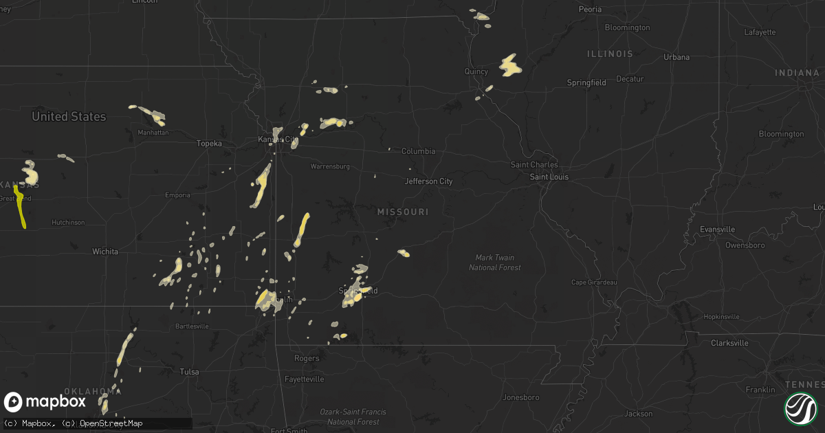
Hail Map in Missouri on June 15, 2013
Get this storm
June 15 map
$229
one time, instant access
Download today. No call, no setup
Keep the $229
Bought the map and want the full workflow? Apply the entire $229 to a subscription within 7 days. None of it is wasted.
Every map, not just this one
This buys you this map. Subscription and you get every map we run, in the markets you choose from a few cities to whole states to nationwide. Plus real-time alerts the moment a storm fires.
Contact data
Name, contact info, occupancy, even credit band for addresses in the footprint. You go from where it hit to who to call.
Become the source they trust
Unlimited branding weather history reports on demand. You already have the documented answer ready for the property owner, and you are the one who showed up with it.
Property data and RoofTrace estimates
Pull up any address you have got, its value and the exact code rules for that jurisdiction, straight from One Click Code. Then RoofTrace estimates the squares, pitch, and roof value, priced the way you price.
Storm reports in Missouri
Missouri
| Date | Description |
|---|---|
| 06/15/20135:45 PM CDT | Delayed report. East of highway 139 off highway d. Pole barn blown apart and several large trees either snapped or blown down. Also had several 8 inch diamter limbs sna |
| 06/15/20135:30 PM CDT | Delayed report. Large tree uprooted. Several smaller tres snapped and a carport lifted and blown down. Estimated 60 mph winds. |
| 06/15/20135:22 PM CDT | 2 foot diameter tree blown down in town |
| 06/15/20135:22 PM CDT | Large limb down blocking the road |
| 06/15/20135:20 PM CDT | A local report indicates 75 MPH wind near CHILLICOTHE |
| 06/15/20135:18 PM CDT | A local report indicates 60 MPH wind near 2 N CHILHOWEE |
| 06/15/20135:10 PM CDT | Relayed by neighboring county em |
| 06/15/20135:02 PM CDT | A local report indicates 60 MPH wind near CHILLICOTHE |
| 06/15/20134:45 PM CDT | Numerous power poles down in warrensburg |
| 06/15/20134:42 PM CDT | Thunderstorm wind gusts were estimated up to 75 mph. An 8 inch diameter tree was snapped in half. Power was also lost. |
| 06/15/20134:34 PM CDT | Tree blown over caused minor hip injury to one person at the lathrop fairgrounds. |
| 06/15/20134:32 PM CDT | Trees down as well. |
| 06/15/20134:20 PM CDT | Thunderstorm winds have gusted from 60 to 70 mph and lasted 5 to 7 minutes. Several trees up to 8 inches in diameter have been snapped off. |
| 06/15/20134:12 PM CDT | Tree branches down up to 3 inches in diameter. |
| 06/15/20134:00 PM CDT | A thunderstorm wind gust at 61 mph was measured at the downtown airport. |
| 06/15/20132:45 PM CDT | Tree large tree blown onto house. Other trees also down in the town of walker. |
| 06/15/20131:20 PM CDT | Strong wind gusts dislodged a dock on table rock lake. This dock was secured within 30 minutes. |
| 06/15/201312:33 PM CDT | Tree down blocking weaver road. |
| 06/15/201312:29 PM CDT | A local report indicates 1.00 inch wind near 6 S SPRINGFIELD |
| 06/15/201312:10 PM CDT | Near james river and hwy 160 near the county line |
| 06/15/201312:00 PM CDT | Reported at national and plainview. |
| 06/15/201311:56 AM CDT | Quarter sized hail reported at freement and republic rd. |
| 06/15/201311:47 AM CDT | A local report indicates 1.75 inch wind near 7 S SPRINGFIELD |
| 06/15/201311:46 AM CDT | Tree down on powerlines near plainview road. |
| 06/15/201311:44 AM CDT | Power lines reported down at plain view and jefferson. |
| 06/15/201311:43 AM CDT | James river and hwy 160 near the greene county and christian county line |
| 06/15/201311:42 AM CDT | A local report indicates 1.00 inch wind near 1 N GALLOWAY |
| 06/15/201311:36 AM CDT | A local report indicates 1.25 inch wind near 4 ENE NIXA |
| 06/15/201311:28 AM CDT | A local report indicates 1.75 inch wind near 7 SSW SPRINGFIELD |
| 06/15/201311:27 AM CDT | A local report indicates 1.00 inch wind near 4 ENE NIXA |
| 06/15/201311:20 AM CDT | A local report indicates 1.75 inch wind near 5 NNE NIXA |
All States Impacted by Hail Map on June 15, 2013
Cities Impacted by Hail Map on June 15, 2013
- Carrollton, MO
- Norborne, MO
- Cheyenne, WY
- Rich Hill, MO
- Butler, MO
- Hume, MO
- Foster, MO
- Breckenridge, MO
- Pine Bluffs, WY
- Brighton, MO
- Fair Grove, MO
- Pleasant Hope, MO
- Liberal, MO
- Lamar, MO
- Fort Collins, CO
- Lebanon, MO
- Holcombe, WI
- Cornell, WI
- Seneca, MO
- Miami, OK
- Galena, KS
- Treece, KS
- Columbus, KS
- Joplin, MO
- Riverton, KS
- Carl Junction, MO
- Baxter Springs, KS
- Quapaw, OK
- Picher, OK
- Holyrood, KS
- Claflin, KS
- Brookline, MO
- Springfield, MO
- Dorrance, KS
- Wilson, KS
- Nunn, CO
- Guthrie, OK
- Virgil, KS
- Toronto, KS
- Nixa, MO
- Tecumseh, OK
- Maud, OK
- Kansas City, MO
- Macomb, OK
- Asher, OK
- Madison, KS
- Orrick, MO
- Morrisville, MO
- Paola, KS
- Fontana, KS
- La Cygne, KS
- Olsburg, KS
- Atoka, OK
- Wapanucka, OK
- Coleman, OK
- Hardin, MO
- Osawatomie, KS
- Yates Center, KS
- Independence, KS
- Jetmore, KS
- Stillwater, OK
- Perkins, OK
- Calhan, CO
- Ramah, CO
- Grain Valley, MO
- Buckner, MO
- Independence, MO
- Blue Springs, MO
- Lees Summit, MO
- Half Way, MO
- Jefferson, IA
- Wills Point, TX
- Tabor, SD
- Carthage, IL
- Dalhart, TX
- Sedan, NM
- Texline, TX
- Yoder, CO
- Rush, CO
- Winnetoon, NE
- Orchard, NE
- Royal, NE
- Bushton, KS
- Benson, AZ
- San Manuel, AZ
- Clayton, NM
- Le Mars, IA
- Marcus, IA
- Hinton, IA
- Kingsley, IA
- Remsen, IA
- Greenville, TX
- Hartington, NE
- Ozark, MO
- Hanston, KS
- Meridian, OK
- Edmond, OK
- Jones, OK
- Arcadia, OK
- Carpenter, WY
- Willard, MO
- Akron, CO
- Hamilton, MO
- Spearman, TX
- Miami, TX
- New Raymer, CO
- Lakin, KS
- Clayton, IL
- Timewell, IL
- Huntsville, IL
- Mount Sterling, IL
- Nevada, MO
- Mayhill, NM
- Jasper, MO
- Hugo, CO
- Genoa, CO
- Buffalo, KS
- Cambridge, KS
- Thornton, IA
- Garner, IA
- Ventura, IA
- Klemme, IA
- Saint George, KS
- Westmoreland, KS
- Bucyrus, KS
- Walnut, KS
- Ireton, IA
- Orange City, IA
- Alton, IA
- Maurice, IA
- Bloomer, WI
- Bushnell, NE
- Cherokee, IA
- Cleghorn, IA
- Spring Hill, KS
- Stilwell, KS
- Centerville, KS
- Louisburg, KS
- Parker, KS
- Randolph, KS
- Green, KS
- Billings, MO
- Clever, MO
- Grenola, KS
- Moline, KS
- Elk Falls, KS
- Verdigre, NE
- Springfield, SD
- Niobrara, NE
- Sibley, MO
- Linn Grove, IA
- Rembrandt, IA
- Sioux Rapids, IA
- Caddo Mills, TX
- Quinlan, TX
- Cherryvale, KS
- Hillsdale, WY
- Burns, WY
- Walker, MO
- Shell Knob, MO
- Lampe, MO
- Ordway, CO
- New London, MO
- Yeso, NM
- Strafford, MO
- Kerens, TX
- Plover, IA
- Rolfe, IA
- West Bend, IA
- Mallard, IA
- Havelock, IA
- Terrell, TX
- Crofton, NE
- Creighton, NE
- Fordyce, NE
- Bloomfield, NE
- Yankton, SD
- Brunswick, NE
- Saint Helena, NE
- Center, NE
- Konawa, OK
- Orlando, FL
- Chambers, NE
- Lu Verne, IA
- Clearwater, NE
- Ewing, NE
- Burwell, NE
- Volin, SD
- Wakonda, SD
- Vermillion, SD
- Honey Grove, TX
- Sumner, TX
- Telephone, TX
- Riverside, MO
- Kansas City, KS
- Alcester, SD
- Gayville, SD
- Burbank, SD
- Centerville, SD
- Beresford, SD
- Aurora, MO
- Morrison, OK
- Perry, OK
- Schell City, MO
- Milo, MO
- Appleton City, MO
- Rockville, MO
- Harwood, MO
- Woodrow, CO
- Howard, KS
- Longton, KS
- Bois D Arc, MO
- Mineola, TX
- Sarcoxie, MO
- Granby, MO
- Sedan, KS
- Niotaze, KS
- Nauvoo, IL
- Sugar City, CO
- Winkelman, AZ
- Vail, AZ
- Weir, KS
- Pittsburg, KS
- Fredonia, KS
- Redfield, KS
- Fort Scott, KS
- Uniontown, KS
- Fort Sumner, NM
- Schaller, IA
- Fall River, KS
- Pawhuska, OK
- Renwick, IA
- Goldfield, IA
- Burlington, KS
- Maramec, OK
- Pawnee, OK
- Mooresville, MO
- Ludlow, MO
- Utica, MO
- Dawn, MO
- Edgewood, TX
- Leoti, KS
- Marienthal, KS
- Hannibal, MO
- Jamestown, MO
- Saint Francis, KS
- Niota, IL
- Red Rock, OK
- Marland, OK
- Ralston, OK
- Republic, MO
- Elk City, KS
- Thayer, KS
- Altoona, KS
- Copan, OK
- Wann, OK
- Marathon, IA
- Laurens, IA
- Oneill, NE
- Utica, SD
- Chico, TX
- Sunset, TX
- Neodesha, KS
- Lindsay, OK
- Blanchard, OK
- Purcell, OK
- Washington, OK
- Thonotosassa, FL
- Piedmont, KS
- Paullina, IA
- Primghar, IA
- Granville, IA
- Ponca City, OK
- Leawood, KS
- Excelsior Springs, MO
- Fairfield, TX
- Albert Lea, MN
- Hartland, MN
- Farlington, KS
- Rogersville, MO
- Coleridge, NE
- Fort Madison, IA
- Montrose, IA
- Norman, OK
- Noble, OK
- Alba, TX
- Neosho, MO
- Irene, SD
- Harrah, OK
- Franktown, CO
- Chillicothe, MO
- Fort Morgan, CO
- Kaufman, TX
- Dodge City, KS
- Diamond, MO
- Ladonia, TX
- Prentice, WI
- Beverly, KS
- Brookville, KS
- Cumberland, WI
- Rice Lake, WI
- Meeker, OK
- Wyandotte, OK
- Tunas, MO
- Camden, MO
- Franklin, MO
- Comstock, WI
- Wamego, KS
- Coyle, OK
- Kinderhook, IL
- Hull, IL
- Scammon, KS
- Cherokee, KS
- Goodell, IA
- Kanawha, IA
- Bowie, TX
- Iola, KS
- Humboldt, KS
- Richmond, MO
- Golden, MO
- Burbank, OK
- Quimby, IA
- Washta, IA
- Meriden, IA
- Pierson, IA
- Streetman, TX
- Reeds, MO
- Carthage, MO
- Bolivar, MO
- Buffalo, MO
- Hawarden, IA
- Cimarron, KS
- Hoisington, KS
- Sheldon, MO
- Versailles, IL
- Camden, IL
- West Point, IA
- Malakoff, TX
- Eustace, TX
- Rocky Comfort, MO
- Fairview, MO
- Wheaton, MO
- Purdy, MO
- Severy, KS
- Elbert, CO
- Batavia, IA
- Ottumwa, IA
- Hedrick, IA
- Ness City, KS
- Mission, KS
- Shawnee, KS
- Lenapah, OK
- S Coffeyville, OK
- Webb City, MO
- Eagle Rock, MO
- Peyton, CO
- Sullivan, WI
- Helenville, WI
- Chanute, KS
- Timnath, CO
- Turtle Lake, WI
- Aurelia, IA
- Alta, IA
- Cedar Vale, KS
- Liberty, KS
- Baldwin City, KS
- Ottawa, KS
- Johnson Creek, WI
- Wausa, NE
- Barry, IL
- Bunker Hill, KS
- Bokchito, OK
- Guymon, OK
- Bronaugh, MO
- Benedict, KS
- Manson, IA
- Somers, IA
- Garden City, KS
- Florence, MO
- Otterville, MO
- Pomona, KS
- Asbury, MO
- Luther, OK
- Lincoln, KS
- Flagler, CO
- Clear Lake, IA
- Mason City, IA
- Kirkville, IA
- Eddyville, IA
- Fremont, IA
- Cedar, IA
- Washburn, MO
- La Harpe, KS
- Tribune, KS
- Burlington, CO
- Joes, CO
- Kirk, CO
- Stratton, CO
- Bennett, CO
- Byers, CO
- Strasburg, CO
- Matheson, CO
- Simla, CO
- Karval, CO
- Brush, CO
- Johnstown, CO
- Milliken, CO
- Gilcrest, CO
- Platteville, CO
- Kersey, CO
- Roggen, CO
- La Salle, CO
- Ault, CO
- Loveland, CO
- Stoneham, CO
- Grover, CO
- St John, KS
- Great Bend, KS
- Hudson, KS
- Ellinwood, KS
- Stafford, KS
- Pawnee Rock, KS
- Larned, KS
- Otis, KS
- Holcomb, KS
- Deerfield, KS
- Beeler, KS
- Dighton, KS
- Spearville, KS
- Arlington, CO


