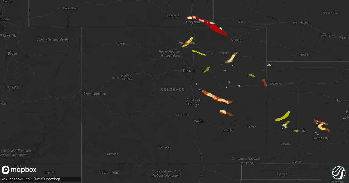
Hail Map in Colorado on June 15, 2013
Get this storm
June 15 map
$229
one time, instant access
Download today. No call, no setup
Keep the $229
Bought the map and want the full workflow? Apply the entire $229 to a subscription within 7 days. None of it is wasted.
Every map, not just this one
This buys you this map. Subscription and you get every map we run, in the markets you choose from a few cities to whole states to nationwide. Plus real-time alerts the moment a storm fires.
Contact data
Name, contact info, occupancy, even credit band for addresses in the footprint. You go from where it hit to who to call.
Become the source they trust
Unlimited branding weather history reports on demand. You already have the documented answer ready for the property owner, and you are the one who showed up with it.
Property data and RoofTrace estimates
Pull up any address you have got, its value and the exact code rules for that jurisdiction, straight from One Click Code. Then RoofTrace estimates the squares, pitch, and roof value, priced the way you price.
Storm reports in Colorado
Colorado
| Date | Description |
|---|---|
| 06/15/20136:52 PM CDT | A local report indicates 2.00 inch wind near 5 W AKRON |
| 06/15/20136:43 PM CDT | A local report indicates 70 MPH wind near 7 NE KARVAL |
| 06/15/20136:27 PM CDT | A local report indicates 1.00 inch wind near 3 W ARRIBA |
| 06/15/20135:37 PM CDT | A local report indicates 1.00 inch wind near 8 S RAMAH |
| 06/15/20135:31 PM CDT | A local report indicates 1.00 inch wind near CALHAN |
| 06/14/201311:59 PM CDT | A local report indicates 1.25 inch wind near 4 WNW NUNN |
| 06/14/201311:39 PM CDT | A local report indicates 1.00 inch wind near 4 NNE TIMNATH |
| 06/14/201311:35 PM CDT | A local report indicates 1.25 inch wind near WNW FORT COLLINS |
| 06/14/201311:34 PM CDT | A local report indicates 1.75 inch wind near FORT COLLINS |
| 06/14/201311:33 PM CDT | A local report indicates 1.00 inch wind near 3 W FORT COLLINS |
| 06/14/201311:31 PM CDT | A local report indicates 1.00 inch wind near S FORT COLLINS |
| 06/14/20138:55 PM CDT | Terrible visibility in blowing dust |
| 06/14/20138:37 PM CDT | Spotter observed wind gust of 67 mph with storm that just passed through. |
| 06/14/20138:08 PM CDT | A local report indicates 58 MPH wind near BURLINGTON |
| 06/14/20137:53 PM CDT | A local report indicates 1.25 inch wind near 1 W STRASBURG |
| 06/14/20137:51 PM CDT | A local report indicates 1.00 inch wind near BENNETT |
| 06/14/20137:45 PM CDT | A local report indicates 1.75 inch wind near 25 N NEW RAYMER |
| 06/14/20137:39 PM CDT | A local report indicates 1.00 inch wind near 5 N AKRON |
| 06/14/20137:11 PM CDT | A local report indicates 58 MPH wind near SEIBERT |
All States Impacted by Hail Map on June 15, 2013
Cities Impacted by Hail Map on June 15, 2013
- Carrollton, MO
- Norborne, MO
- Cheyenne, WY
- Rich Hill, MO
- Butler, MO
- Hume, MO
- Foster, MO
- Breckenridge, MO
- Pine Bluffs, WY
- Brighton, MO
- Fair Grove, MO
- Pleasant Hope, MO
- Liberal, MO
- Lamar, MO
- Fort Collins, CO
- Lebanon, MO
- Holcombe, WI
- Cornell, WI
- Seneca, MO
- Miami, OK
- Galena, KS
- Treece, KS
- Columbus, KS
- Joplin, MO
- Riverton, KS
- Carl Junction, MO
- Baxter Springs, KS
- Quapaw, OK
- Picher, OK
- Holyrood, KS
- Claflin, KS
- Brookline, MO
- Springfield, MO
- Dorrance, KS
- Wilson, KS
- Nunn, CO
- Guthrie, OK
- Virgil, KS
- Toronto, KS
- Nixa, MO
- Tecumseh, OK
- Maud, OK
- Kansas City, MO
- Macomb, OK
- Asher, OK
- Madison, KS
- Orrick, MO
- Morrisville, MO
- Paola, KS
- Fontana, KS
- La Cygne, KS
- Olsburg, KS
- Atoka, OK
- Wapanucka, OK
- Coleman, OK
- Hardin, MO
- Osawatomie, KS
- Yates Center, KS
- Independence, KS
- Jetmore, KS
- Stillwater, OK
- Perkins, OK
- Calhan, CO
- Ramah, CO
- Grain Valley, MO
- Buckner, MO
- Independence, MO
- Blue Springs, MO
- Lees Summit, MO
- Half Way, MO
- Jefferson, IA
- Wills Point, TX
- Tabor, SD
- Carthage, IL
- Dalhart, TX
- Sedan, NM
- Texline, TX
- Yoder, CO
- Rush, CO
- Winnetoon, NE
- Orchard, NE
- Royal, NE
- Bushton, KS
- Benson, AZ
- San Manuel, AZ
- Clayton, NM
- Le Mars, IA
- Marcus, IA
- Hinton, IA
- Kingsley, IA
- Remsen, IA
- Greenville, TX
- Hartington, NE
- Ozark, MO
- Hanston, KS
- Meridian, OK
- Edmond, OK
- Jones, OK
- Arcadia, OK
- Carpenter, WY
- Willard, MO
- Akron, CO
- Hamilton, MO
- Spearman, TX
- Miami, TX
- New Raymer, CO
- Lakin, KS
- Clayton, IL
- Timewell, IL
- Huntsville, IL
- Mount Sterling, IL
- Nevada, MO
- Mayhill, NM
- Jasper, MO
- Hugo, CO
- Genoa, CO
- Buffalo, KS
- Cambridge, KS
- Thornton, IA
- Garner, IA
- Ventura, IA
- Klemme, IA
- Saint George, KS
- Westmoreland, KS
- Bucyrus, KS
- Walnut, KS
- Ireton, IA
- Orange City, IA
- Alton, IA
- Maurice, IA
- Bloomer, WI
- Bushnell, NE
- Cherokee, IA
- Cleghorn, IA
- Spring Hill, KS
- Stilwell, KS
- Centerville, KS
- Louisburg, KS
- Parker, KS
- Randolph, KS
- Green, KS
- Billings, MO
- Clever, MO
- Grenola, KS
- Moline, KS
- Elk Falls, KS
- Verdigre, NE
- Springfield, SD
- Niobrara, NE
- Sibley, MO
- Linn Grove, IA
- Rembrandt, IA
- Sioux Rapids, IA
- Caddo Mills, TX
- Quinlan, TX
- Cherryvale, KS
- Hillsdale, WY
- Burns, WY
- Walker, MO
- Shell Knob, MO
- Lampe, MO
- Ordway, CO
- New London, MO
- Yeso, NM
- Strafford, MO
- Kerens, TX
- Plover, IA
- Rolfe, IA
- West Bend, IA
- Mallard, IA
- Havelock, IA
- Terrell, TX
- Crofton, NE
- Creighton, NE
- Fordyce, NE
- Bloomfield, NE
- Yankton, SD
- Brunswick, NE
- Saint Helena, NE
- Center, NE
- Konawa, OK
- Orlando, FL
- Chambers, NE
- Lu Verne, IA
- Clearwater, NE
- Ewing, NE
- Burwell, NE
- Volin, SD
- Wakonda, SD
- Vermillion, SD
- Honey Grove, TX
- Sumner, TX
- Telephone, TX
- Riverside, MO
- Kansas City, KS
- Alcester, SD
- Gayville, SD
- Burbank, SD
- Centerville, SD
- Beresford, SD
- Aurora, MO
- Morrison, OK
- Perry, OK
- Schell City, MO
- Milo, MO
- Appleton City, MO
- Rockville, MO
- Harwood, MO
- Woodrow, CO
- Howard, KS
- Longton, KS
- Bois D Arc, MO
- Mineola, TX
- Sarcoxie, MO
- Granby, MO
- Sedan, KS
- Niotaze, KS
- Nauvoo, IL
- Sugar City, CO
- Winkelman, AZ
- Vail, AZ
- Weir, KS
- Pittsburg, KS
- Fredonia, KS
- Redfield, KS
- Fort Scott, KS
- Uniontown, KS
- Fort Sumner, NM
- Schaller, IA
- Fall River, KS
- Pawhuska, OK
- Renwick, IA
- Goldfield, IA
- Burlington, KS
- Maramec, OK
- Pawnee, OK
- Mooresville, MO
- Ludlow, MO
- Utica, MO
- Dawn, MO
- Edgewood, TX
- Leoti, KS
- Marienthal, KS
- Hannibal, MO
- Jamestown, MO
- Saint Francis, KS
- Niota, IL
- Red Rock, OK
- Marland, OK
- Ralston, OK
- Republic, MO
- Elk City, KS
- Thayer, KS
- Altoona, KS
- Copan, OK
- Wann, OK
- Marathon, IA
- Laurens, IA
- Oneill, NE
- Utica, SD
- Chico, TX
- Sunset, TX
- Neodesha, KS
- Lindsay, OK
- Blanchard, OK
- Purcell, OK
- Washington, OK
- Thonotosassa, FL
- Piedmont, KS
- Paullina, IA
- Primghar, IA
- Granville, IA
- Ponca City, OK
- Leawood, KS
- Excelsior Springs, MO
- Fairfield, TX
- Albert Lea, MN
- Hartland, MN
- Farlington, KS
- Rogersville, MO
- Coleridge, NE
- Fort Madison, IA
- Montrose, IA
- Norman, OK
- Noble, OK
- Alba, TX
- Neosho, MO
- Irene, SD
- Harrah, OK
- Franktown, CO
- Chillicothe, MO
- Fort Morgan, CO
- Kaufman, TX
- Dodge City, KS
- Diamond, MO
- Ladonia, TX
- Prentice, WI
- Beverly, KS
- Brookville, KS
- Cumberland, WI
- Rice Lake, WI
- Meeker, OK
- Wyandotte, OK
- Tunas, MO
- Camden, MO
- Franklin, MO
- Comstock, WI
- Wamego, KS
- Coyle, OK
- Kinderhook, IL
- Hull, IL
- Scammon, KS
- Cherokee, KS
- Goodell, IA
- Kanawha, IA
- Bowie, TX
- Iola, KS
- Humboldt, KS
- Richmond, MO
- Golden, MO
- Burbank, OK
- Quimby, IA
- Washta, IA
- Meriden, IA
- Pierson, IA
- Streetman, TX
- Reeds, MO
- Carthage, MO
- Bolivar, MO
- Buffalo, MO
- Hawarden, IA
- Cimarron, KS
- Hoisington, KS
- Sheldon, MO
- Versailles, IL
- Camden, IL
- West Point, IA
- Malakoff, TX
- Eustace, TX
- Rocky Comfort, MO
- Fairview, MO
- Wheaton, MO
- Purdy, MO
- Severy, KS
- Elbert, CO
- Batavia, IA
- Ottumwa, IA
- Hedrick, IA
- Ness City, KS
- Mission, KS
- Shawnee, KS
- Lenapah, OK
- S Coffeyville, OK
- Webb City, MO
- Eagle Rock, MO
- Peyton, CO
- Sullivan, WI
- Helenville, WI
- Chanute, KS
- Timnath, CO
- Turtle Lake, WI
- Aurelia, IA
- Alta, IA
- Cedar Vale, KS
- Liberty, KS
- Baldwin City, KS
- Ottawa, KS
- Johnson Creek, WI
- Wausa, NE
- Barry, IL
- Bunker Hill, KS
- Bokchito, OK
- Guymon, OK
- Bronaugh, MO
- Benedict, KS
- Manson, IA
- Somers, IA
- Garden City, KS
- Florence, MO
- Otterville, MO
- Pomona, KS
- Asbury, MO
- Luther, OK
- Lincoln, KS
- Flagler, CO
- Clear Lake, IA
- Mason City, IA
- Kirkville, IA
- Eddyville, IA
- Fremont, IA
- Cedar, IA
- Washburn, MO
- La Harpe, KS
- Tribune, KS
- Burlington, CO
- Joes, CO
- Kirk, CO
- Stratton, CO
- Bennett, CO
- Byers, CO
- Strasburg, CO
- Matheson, CO
- Simla, CO
- Karval, CO
- Brush, CO
- Johnstown, CO
- Milliken, CO
- Gilcrest, CO
- Platteville, CO
- Kersey, CO
- Roggen, CO
- La Salle, CO
- Ault, CO
- Loveland, CO
- Stoneham, CO
- Grover, CO
- St John, KS
- Great Bend, KS
- Hudson, KS
- Ellinwood, KS
- Stafford, KS
- Pawnee Rock, KS
- Larned, KS
- Otis, KS
- Holcomb, KS
- Deerfield, KS
- Beeler, KS
- Dighton, KS
- Spearville, KS
- Arlington, CO


