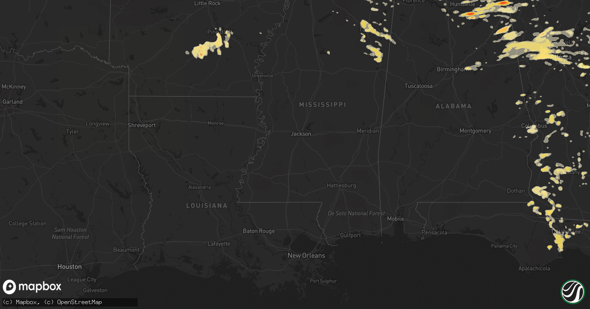
Hail Map in Tennessee on June 15, 2011
Get this storm
June 15 map
$229
one time, instant access
Download today. No call, no setup
Keep the $229
Bought the map and want the full workflow? Apply the entire $229 to a subscription within 7 days. None of it is wasted.
Every map, not just this one
This buys you this map. Subscription and you get every map we run, in the markets you choose from a few cities to whole states to nationwide. Plus real-time alerts the moment a storm fires.
Contact data
Name, contact info, occupancy, even credit band for addresses in the footprint. You go from where it hit to who to call.
Become the source they trust
Unlimited branding weather history reports on demand. You already have the documented answer ready for the property owner, and you are the one who showed up with it.
Property data and RoofTrace estimates
Pull up any address you have got, its value and the exact code rules for that jurisdiction, straight from One Click Code. Then RoofTrace estimates the squares, pitch, and roof value, priced the way you price.
Storm reports in Tennessee
Tennessee
| Date | Description |
|---|---|
| 06/15/20116:55 PM CDT | Quarter size hail 12 miles south of lawrenceburg. |
| 06/15/20116:50 PM CDT | Trees and power lines down just southwest of town of counce near pickwick landing. |
| 06/15/20116:45 PM CDT | A local report indicates 1.50 inch wind near MILLEDGEVILLE |
| 06/15/20116:43 PM CDT | Golf ball hail reported in the town of nixon. |
| 06/15/20116:20 PM CDT | Thunderstorm wind gust of 60 mph and half inch hail in far southwest dickson county. |
| 06/15/20116:20 PM CDT | A few trees and powerlines down on branston road and tallant road between collegedale and ooltewah. Reported by dispatch. |
| 06/15/20115:47 PM CDT | Half dollar size hail in waverly. |
| 06/15/20115:46 PM CDT | One tree down on highway 108. Reported by dispatch. |
| 06/15/20115:45 PM CDT | Several trees and powerlines down on highway 127 near miller cove road. Reported by dispatch. |
| 06/15/20115:37 PM CDT | Trees reported down across the county. |
| 06/15/20115:30 PM CDT | Trees were blown down on highway 55. |
| 06/15/20115:20 PM CDT | Several trees and powerlines down in lone oak. Reported by ema. |
| 06/15/20115:18 PM CDT | Quarter sized hail in lone oak. Reported by ema. |
| 06/15/20115:16 PM CDT | Trees were reported down on shelbyville highway and lynchburg highway. |
| 06/15/20115:07 PM CDT | Several trees down in and around pikeville. One on highway 30e and another on college street. Reported by dispatch. |
| 06/15/20115:06 PM CDT | A local report indicates 1.00 inch wind near 3 NNE WINCHESTER |
| 06/15/20115:05 PM CDT | 2 inch hail at mccabe golf course in downtown nashville. |
| 06/15/20115:05 PM CDT | Hen egg sized hail in turtletown. Reported by spotter. |
| 06/15/20115:02 PM CDT | A local report indicates 1.00 inch wind near 4 SW DICKSON |
| 06/15/20114:58 PM CDT | Observed near charlotte pike and annex drive |
| 06/15/20114:55 PM CDT | A local report indicates 1.00 inch wind near 5 NE COLUMBIA |
| 06/15/20114:50 PM CDT | A local report indicates 1.00 inch wind near 6 SW DICKSON |
| 06/15/20114:40 PM CDT | Quarter sized hail in cleveland. Reported by spotter. |
| 06/15/20114:38 PM CDT | Numerous trees...powerlines and power poles down on highway 58 between highway 68 and highway 30. Reported by dispatch. |
| 06/15/20114:30 PM CDT | Golf ball sized hail on highway 58. Reported by spotter. |
| 06/15/20114:25 PM CDT | Roof blown off of a home in lawrenceburg. Trees down in and close to lawrenceburg. |
| 06/15/20114:25 PM CDT | Observed at pelham |
| 06/15/20114:23 PM CDT | Quarter to half dollar sized hail that the sequoyah nucler plantn and near hixson. |
| 06/15/20114:15 PM CDT | Trees down and some roof damage across western portion of the county. |
| 06/15/20114:05 PM CDT | Trees down across the southern portion of the county. |
| 06/15/20114:00 PM CDT | A local report indicates 1.25 inch wind near OLIVE HILL |
| 06/15/20113:50 PM CDT | Trees down across much of northwestern rutherford county. |
| 06/15/20113:45 PM CDT | A local report indicates 1.00 inch wind near 1 W DUNLAP |
| 06/15/20113:30 PM CDT | Two trees were knocked down. |
| 06/15/20113:30 PM CDT | A local report indicates 1.00 inch wind near 2 NE SAVANNAH |
| 06/15/20113:25 PM CDT | A local report indicates 1.00 inch wind near 1 W SALTILLO |
| 06/15/20113:22 PM CDT | A local report indicates 1.00 inch wind near 10 NW NASHVILLE |
| 06/15/20113:20 PM CDT | Hail occurred at harding road and interstate 24. |
| 06/15/20113:15 PM CDT | Observed at crieve hall in nashville |
| 06/15/20113:08 PM CDT | Trees down across the county. |
| 06/15/20113:08 PM CDT | A local report indicates 1.00 inch wind near BELLE MEADE |
| 06/15/20112:39 PM CDT | A local report indicates 1.00 inch wind near 4 NE HOHENWALD |
| 06/15/20112:16 PM CDT | A local report indicates 1.00 inch wind near 6 W CROSSVILLE |
| 06/15/20111:55 PM CDT | Hail was observed on lick creek road |
| 06/15/20111:15 PM CDT | A local report indicates 1.00 inch wind near 10 WSW SUNBRIGHT |
| 06/15/20111:15 PM CDT | Spotter believed winds caused by wet microburst. |
| 06/15/20111:00 PM CDT | One tree down on half moon road. Reported by dispatch. |
| 06/15/201112:50 PM CDT | Several trees down countywide. Reported by dispatch. |
| 06/15/201112:35 PM CDT | A local report indicates 1.00 inch wind near 5 SE CHATTANOOGA |
| 06/15/201112:22 PM CDT | A local report indicates 1.00 inch wind near 10 E MONTEREY |
| 06/15/201112:20 PM CDT | A local report indicates 1.00 inch wind near ROCKWOOD |
| 06/15/201112:18 PM CDT | Law enforcement rpt golf ball sized hail along hanging limb hwy in overton co. |
| 06/15/201112:05 PM CDT | Spotter rpt quarter sized hail |
| 06/15/201111:59 AM CDT | Quarter sized hail in double springs. |
| 06/15/201111:56 AM CDT | A local report indicates 1.75 inch wind near 5 N NASHVILLE |
| 06/15/201111:55 AM CDT | A local report indicates 1.00 inch wind near COOKEVILLE |
| 06/15/201111:50 AM CDT | One tree down on mt calvary rd. |
| 06/15/201110:59 AM CDT | Spotter rpt quarter sized hail. |
| 06/14/20119:50 PM CDT | Golfball size hail 2 miles west of cookeville. |
| 06/14/20119:10 PM CDT | Quarter size hail in pleasent shade. |
| 06/14/20119:10 PM CDT | Half dollar hail reported 3 miles north of cookeville. |
| 06/14/20117:45 PM CDT | Trees blown down and small hail in and near pulaski. |
| 06/14/20117:35 PM CDT | A local report indicates 60 MPH wind near LORETTO |
| 06/14/20117:22 PM CDT | Trees down and up to quarter size hail reported across southern portions of the county. |
| 06/14/20117:18 PM CDT | Half dollar hail reported 2 miles east of spring hill. |
All States Impacted by Hail Map on June 15, 2011
Cities Impacted by Hail Map on June 15, 2011
- Bearden, AR
- Star City, AR
- Thornton, AR
- New Edinburg, AR
- Kingsland, AR
- Ivan, AR
- Sparkman, AR
- Pine Bluff, AR
- Rison, AR
- Fordyce, AR
- Jasper, GA
- Columbus, MS
- Amory, MS
- West Point, MS
- Okolona, MS
- Aberdeen, MS
- Caledonia, MS
- Hamilton, MS
- Providence, KY
- Nebo, KY
- Buchanan, GA
- Sparta, TN
- Scottsville, KY
- Fountain Run, KY
- Sumterville, FL
- Bushnell, FL
- Colquitt, GA
- Curtis, NE
- Adairsville, GA
- Aline, OK
- Alva, OK
- Freedom, OK
- Carmen, OK
- Waynoka, OK
- Campbellsville, KY
- Winter Haven, FL
- Turtletown, TN
- Murphy, NC
- Copperhill, TN
- Okeechobee, FL
- Leesburg, AL
- Fort Payne, AL
- Cedar Bluff, AL
- Gaylesville, AL
- Collinsville, AL
- Soperton, GA
- Tarrytown, GA
- Smithville, MS
- Greenwood Springs, MS
- Tremont, MS
- Fowler, KS
- Minneola, KS
- Hudson, KY
- McDaniels, KY
- Leitchfield, KY
- Hardinsburg, KY
- Westview, KY
- Cartersville, GA
- Taylorsville, GA
- Pell City, AL
- Screven, GA
- Cuthbert, GA
- Richland, GA
- Lumpkin, GA
- Weston, GA
- Horse Branch, KY
- Olaton, KY
- Caneyville, KY
- Collinwood, TN
- McRae Helena, GA
- Lumber City, GA
- Hoschton, GA
- Jefferson, GA
- Winder, GA
- Belden, MS
- Blue Springs, MS
- Saltillo, MS
- Tupelo, MS
- Acworth, GA
- Bowling Green, KY
- Cedartown, GA
- Rockmart, GA
- Smiths Grove, KY
- Oakland, KY
- Jennings, KS
- Clayton, KS
- Sylvester, GA
- Crawfordville, FL
- Decherd, TN
- Monteagle, TN
- Sewanee, TN
- South Pittsburg, TN
- Hillsboro, TN
- Tracy City, TN
- Pelham, TN
- Sequatchie, TN
- Whitwell, TN
- Douglasville, GA
- Winston, GA
- Villa Rica, GA
- Scottsboro, AL
- Arapahoe, NE
- Edison, NE
- Leesburg, FL
- Webster, FL
- Lady Lake, FL
- Brooksville, FL
- Inverness, FL
- Coleman, FL
- Lake Panasoffkee, FL
- Wildwood, FL
- The Villages, FL
- Floral City, FL
- Hernando, FL
- Center Hill, FL
- Fruitland Park, FL
- Simpsonville, SC
- Micanopy, FL
- Hawthorne, FL
- Wellfleet, NE
- North Platte, NE
- Pine Mountain, GA
- French Lick, IN
- Covington, GA
- Jackson, GA
- Hilton Head Island, SC
- Canal Point, FL
- Eagleville, TN
- Rockvale, TN
- Shepherd, MT
- Newton, GA
- Camilla, GA
- Talbotton, GA
- Junction City, GA
- Edmonton, KY
- Center, KY
- Horse Cave, KY
- Glasgow, KY
- Knob Lick, KY
- Santa Fe, TN
- Lyles, TN
- Franklin, TN
- Primm Springs, TN
- Rentz, GA
- Dublin, GA
- Whigham, GA
- Climax, GA
- Huntsville, AL
- Brownsboro, AL
- Greenwood, SC
- Hodges, SC
- Abbeville, SC
- Ninety Six, SC
- Dickson, TN
- Spring City, TN
- Evensville, TN
- Elk Horn, KY
- Greensburg, KY
- Knifley, KY
- Hardyville, KY
- Columbia, KY
- Buffalo, OK
- Laverne, OK
- Englewood, KS
- May, OK
- Ashland, KS
- Rosston, OK
- Fargo, OK
- Fort Supply, OK
- Ensign, KS
- Rising Fawn, GA
- Trenton, GA
- Loganville, GA
- Immokalee, FL
- Naples, FL
- Lyons, GA
- Perry, OK
- Frostproof, FL
- Lynnville, TN
- Cornersville, TN
- Live Oak, FL
- Edson, KS
- Winona, KS
- Wallace, KS
- Parksville, KY
- Quincy, FL
- Guild, TN
- Bon Aqua, TN
- New Johnsonville, TN
- Thompsons Station, TN
- Fairview, TN
- Columbia, TN
- McEwen, TN
- Waverly, TN
- Nunnelly, TN
- Felda, FL
- Labelle, FL
- Palestine, IL
- Carlisle, IN
- Franklin, NC
- Groveland, FL
- Clermont, FL
- Winter Garden, FL
- Sturgis, KY
- Marion, KY
- Homosassa, FL
- Alpine, TN
- Rickman, TN
- Livingston, TN
- Cookeville, TN
- Hilham, TN
- Byrdstown, TN
- Monroe, TN
- Allons, TN
- Monterey, TN
- Mcminnville, TN
- Watkinsville, GA
- Kensington, KS
- Hartsville, TN
- Castalian Springs, TN
- Bethpage, TN
- Broken Arrow, OK
- Tulsa, OK
- Bartow, FL
- Lake Wales, FL
- Vine Grove, KY
- Radcliff, KY
- Rineyville, KY
- Fort Meade, FL
- Dodge City, KS
- Woodward, OK
- Ocala, FL
- Belleview, FL
- Summerfield, FL
- Ocklawaha, FL
- East Dublin, GA
- Brooklet, GA
- White Hall, AR
- Carthage, TN
- Brush Creek, TN
- Gordonsville, TN
- Pikeville, TN
- Chattanooga, TN
- Soddy Daisy, TN
- Harrison, TN
- Ooltewah, TN
- Hixson, TN
- Lebanon, KY
- Sapelo Island, GA
- Albany, GA
- Leesburg, GA
- Gradyville, KY
- Mentone, AL
- Valley Head, AL
- Henagar, AL
- Menlo, GA
- Smith Center, KS
- Lebanon, KS
- Spencer, TN
- Rock Island, TN
- Doyle, TN
- Quebeck, TN
- Cumming, GA
- Cusseta, GA
- Buena Vista, GA
- Irvington, KY
- Guston, KY
- Ekron, KY
- Garfield, KY
- Harned, KY
- Custer, KY
- Levant, KS
- Brewster, KS
- Sharon Springs, KS
- Auburndale, FL
- Lake Alfred, FL
- Davenport, FL
- Haines City, FL
- Eagle Lake, FL
- Polk City, FL
- Lakeland, FL
- Lewisburg, KY
- Crofton, KY
- Greenville, KY
- Sharon Grove, KY
- White Plains, KY
- Hopkinsville, KY
- Elkton, KY
- Canton, NC
- Pinehurst, GA
- Unadilla, GA
- Pisgah, AL
- Warne, NC
- Brasstown, NC
- Marble, NC
- Hayesville, NC
- Tallahassee, FL
- Monticello, FL
- Perry, FL
- Orleans, NE
- Alma, NE
- Stamford, NE
- Hawesville, KY
- Cannelton, IN
- Cloverport, KY
- Clarkson, KY
- Falls Of Rough, KY
- Jackson, MO
- Lancaster, TN
- Hickman, TN
- Liberty, TN
- Alexandria, TN
- College Grove, TN
- Spring Hill, TN
- Harriman, TN
- Pekin, IN
- Palmyra, IN
- Coleman, GA
- Edison, GA
- Greer, SC
- Woodruff, SC
- Cub Run, KY
- Munfordville, KY
- Marshall, OK
- Bison, OK
- Hennessey, OK
- Tompkinsville, KY
- Holland, KY
- Woodbury, TN
- Canton, GA
- Waynesburg, KY
- Yosemite, KY
- Eubank, KY
- Bethelridge, KY
- Kings Mountain, KY
- Piedmont, AL
- Sebring, FL
- Lorida, FL
- Willow Island, NE
- Gothenburg, NE
- Cozad, NE
- Hardin, MT
- Dubois, IN
- Gravel Switch, KY
- Dallas, GA
- Union, SC
- Enoree, SC
- Cherokee, NC
- Ider, AL
- Flat Rock, AL
- Metter, GA
- Gamaliel, KY
- Guyton, GA
- Glenwood, GA
- Bainbridge, GA
- Hodgenville, KY
- Box Springs, GA
- Vero Beach, FL
- Port Saint Lucie, FL
- Fort Pierce, FL
- Indiantown, FL
- Morgantown, KY
- Rochester, KY
- Mount Washington, KY
- North Fort Myers, FL
- Fort Myers, FL
- Lake Butler, FL
- Gainesville, FL
- Alachua, FL
- Brooker, FL
- Kellyville, OK
- Beggs, OK
- Mounds, OK
- Sapulpa, OK
- Saint Francis, KY
- Springfield, KY
- Loretto, KY
- Raywick, KY
- Moscow, TN
- Lamar, MS
- Deerfield, KS
- Garden City, KS
- Marienthal, KS
- Leoti, KS
- Holcomb, KS
- Somerville, TN
- Williston, TN
- Joppa, AL
- Arab, AL
- Hollywood, AL
- Woodville, AL
- Higdon, AL
- Silver Point, TN
- Whitleyville, TN
- Crossville, TN
- Buffalo Valley, TN
- Bloomington Springs, TN
- Gainesboro, TN
- Granville, TN
- Baxter, TN
- Grandview, TN
- Shady Dale, GA
- Mansfield, GA
- Leary, GA
- Signal Mountain, TN
- Dunlap, TN
- Lexington, AL
- Madison, FL
- Lee, FL
- Inglis, FL
- Oxford, NE
- Fairburn, GA
- Fayetteville, GA
- Prairie, MS
- Bronston, KY
- Burnside, KY
- Monticello, KY
- Sopchoppy, FL
- Yale, OK
- Cushing, OK
- Ripley, OK
- Weirsdale, FL
- Punta Gorda, FL
- Dickens, NE
- Simpson, IL
- Vienna, IL
- Ozark, IL
- Fairmont, OK
- Garber, OK
- Bascom, FL
- Gordon, AL
- Donalsonville, GA
- Princeton, AL
- New Market, AL
- Parkers Lake, KY
- Cecilia, KY
- Falkner, MS
- Ripley, MS
- Corinth, MS
- Walnut, MS
- Tiplersville, MS
- Elizabethtown, KY
- Booneville, MS
- Charlotte, TN
- Coffeeville, MS
- Nashville, TN
- Hermitage, TN
- Madison, TN
- Whites Creek, TN
- Old Hickory, TN
- Ashland City, TN
- Cumberland City, TN
- Tennessee Ridge, TN
- Clarksville, TN
- Joelton, TN
- Chapmansboro, TN
- Southside, TN
- Indian Mound, TN
- Palmyra, TN
- Cunningham, TN
- Cumberland Furnace, TN
- Dover, TN
- Erin, TN
- Okeene, OK
- Langston, AL
- Jonesboro, IL
- Anna, IL
- Lehigh Acres, FL
- Alva, FL
- Atlanta, GA
- Coweta, OK
- Okmulgee, OK
- Oktaha, OK
- Morris, OK
- Haskell, OK
- Porter, OK
- Bixby, OK
- Muskogee, OK
- Boynton, OK
- Leoma, TN
- Wartrace, TN
- Shelbyville, TN
- Normandy, TN
- Lyman, SC
- Havana, FL
- Manchester, TN
- Chapel Hill, TN
- Port Wentworth, GA
- Rincon, GA
- Clyo, GA
- Springfield, GA
- Plantersville, MS
- Fulton, MS
- Mantachie, MS
- Mooreville, MS
- Nettleton, MS
- Waleska, GA
- White, GA
- Oakfield, GA
- Palm Bay, FL
- Titusville, FL
- Tell City, IN
- Ailey, GA
- Adrian, GA
- Dexter, GA
- Vidalia, GA
- Reidsville, GA
- Rockledge, GA
- Selden, KS
- Gem, KS
- Lenora, KS
- Colby, KS
- Dresden, KS
- Rexford, KS
- Norton, KS
- Gallatin, TN
- Burkesville, KY
- Albany, KY
- Winchester, TN
- Goreville, IL
- Mankato, KS
- Glen Elder, KS
- Stevenson, AL
- Savannah, TN
- Michie, TN
- Iron City, TN
- Guys, TN
- Shiloh, TN
- Ramer, TN
- Stantonville, TN
- Selmer, TN
- Counce, TN
- Cypress Inn, TN
- Lutts, TN
- Hawkinsville, GA
- Pawnee, OK
- Loudon, TN
- Ten Mile, TN
- Philadelphia, TN
- Cleo Springs, OK
- Dacoma, OK
- Fairview, OK
- Ringwood, OK
- Wellford, SC
- Guntown, MS
- Beaverton, AL
- Hamilton, AL
- Detroit, AL
- Sulligent, AL
- Social Circle, GA
- Ingalls, KS
- Morris, GA
- Lulu, FL
- Monroe, GA
- Danielsville, GA
- Nicholson, GA
- Commerce, GA
- Hull, GA
- Colbert, GA
- Brentwood, TN
- Antioch, TN
- Athens, AL
- Anderson, AL
- Rogersville, AL
- Elkmont, AL
- Lester, AL
- Holland, IN
- Stendal, IN
- Gentryville, IN
- Winslow, IN
- Tennyson, IN
- Dale, IN
- Oakland City, IN
- Grant, AL
- Middleton, TN
- Dunnellon, FL
- Mcpherson, KS
- Lindsborg, KS
- Mauckport, IN
- Olivehill, TN
- Scott City, KS
- Cimarron, KS
- Kiefer, OK
- Lake City, FL
- Greensboro, GA
- Union Point, GA
- Stephens, GA
- Alamo, GA
- Smyrna, TN
- Red Rock, OK
- Morrison, OK
- Tullahoma, TN
- Loxahatchee, FL
- Athens, GA
- McAlpin, FL
- Mayo, FL
- Grady, AR
- Yorktown, AR
- Altheimer, AR
- Pleasant Shade, TN
- Riddleton, TN
- Ochopee, FL
- Smithville, TN
- Dowelltown, TN
- Smyrna, GA
- Moore Haven, FL
- Arrington, TN
- Whiteside, TN
- Rossville, GA
- Ringgold, GA
- Estillfork, AL
- Hollytree, AL
- Gurley, AL
- Five Points, AL
- Lagrange, GA
- Lebanon, TN
- Rockwood, TN
- Roswell, GA
- Estill Springs, TN
- Brunswick, GA
- Saint Simons Island, GA
- Hosford, FL
- Harrisburg, AR
- Centerville, TN
- Duck River, TN
- Vanleer, TN
- Waynesville, NC
- Maggie Valley, NC
- Blakely, GA
- Jakin, GA
- Greenville, SC
- New Site, MS
- Dennis, MS
- Powder Springs, GA
- Hiram, GA
- Silver Springs, FL
- New Hope, AL
- Owens Cross Roads, AL
- Cross Plains, TN
- Grand Junction, TN
- La Grange, TN
- Collierville, TN
- Rossville, TN
- Ashland, MS
- Michigan City, MS
- Saulsbury, TN
- La Vergne, TN
- Cape Girardeau, MO
- McClure, IL
- Oak Ridge, MO
- Ellaville, GA
- Perry, GA
- Fairmount, GA
- Jamestown, TN
- Deer Lodge, TN
- Sunbright, TN
- Magnolia, KY
- Buffalo, KY
- Mount Sherman, KY
- Warwick, GA
- Kenansville, FL
- Waverly Hall, GA
- Woodland, GA
- Savannah, GA
- Perryville, KY
- New Haven, KY
- Bradfordsville, KY
- Mackville, KY
- Bardstown, KY
- Upton, KY
- New Hope, KY
- Bonnieville, KY
- Summersville, KY
- Boston, KY
- Willisburg, KY
- Sonora, KY
- Saint Catharine, KY
- Annapolis, IL
- Robinson, IL
- Ralston, OK
- Duncan, SC
- Germantown, TN
- Memphis, TN
- Nolensville, TN
- Tanner, AL
- Decatur, AL
- Dutton, AL
- Republican City, NE
- Phillipsburg, KS
- Naponee, NE
- Agra, KS
- Statham, GA
- Bogart, GA
- Odum, GA
- Jesup, GA
- Belvidere, TN
- Mulberry, TN
- Lynchburg, TN
- Salley, SC
- Eustis, NE
- Twin City, GA
- Lawrenceville, IL
- Vincennes, IN
- Fisher, AR
- Cherry Valley, AR
- White Springs, FL
- Courtland, KS
- Norway, KS
- Formoso, KS
- Jewell, KS
- Jamestown, KS
- Scandia, KS
- Buffalo, SC
- Greenbrier, TN
- Hornsby, TN
- Altamont, TN
- Beersheba Springs, TN
- Lawrenceburg, TN
- Nash, OK
- Section, AL
- Toney, AL
- Monticello, GA
- Venus, FL
- Okatie, SC
- Hardeeville, SC
- Columbus, GA
- Phenix City, AL
- Seale, AL
- Fort Benning, GA
- Fort Mitchell, AL
- Agra, OK
- Amorita, OK
- Cleveland, TN
- McDonald, TN
- Buford, GA
- Orlando, FL
- Mooreland, OK
- Randall, KS
- Auburntown, TN
- Watertown, TN
- Milton, TN
- White Bluff, TN
- Murfreesboro, TN
- Mount Juliet, TN
- Readyville, TN
- Mount Pleasant, TN
- Hampshire, TN
- Hohenwald, TN
- Lascassas, TN
- Linden, TN
- Stewart, TN
- Pegram, TN
- Williamsport, TN
- Chiefland, FL
- Bronson, FL
- Morriston, FL
- Otter Creek, FL
- Westpoint, TN
- Waynesboro, TN
- Cloverdale, IN
- Lake Placid, FL
- Arcadia, FL
- Covington, OK
- Douglas, OK
- Eastman, GA
- Chauncey, GA
- Pinetta, FL
- Zolfo Springs, FL
- Bristow, OK
- Drumright, OK
- Oneida, TN
- Kremlin, OK
- Kiowa, KS
- Waldron, KS
- Jet, OK
- Medford, OK
- Burlington, OK
- Helena, OK
- Cherokee, OK
- Wakita, OK
- Pond Creek, OK
- Enid, OK
- Manchester, OK
- Summerville, GA
- Lyerly, GA
- Kemp, TX
- Mabank, TX
- Tallapoosa, GA
- Bremen, GA
- Alpharetta, GA
- Neeses, SC
- Ethridge, TN
- Rienzi, MS
- Hickory Valley, TN
- Florence, AL
- Bolivar, TN
- Pocahontas, TN
- Loretto, TN
- Bath Springs, TN
- Goodspring, TN
- Clifton, TN
- Adamsville, TN
- Pulaski, TN
- Hendersonville, TN
- Norway, SC
- Blackville, SC
- Leicester, NC
- Christmas, FL
- Arnoldsville, GA
- Stillwater, OK
- Sheridan Lake, CO
- La Fayette, GA
- Floyds Knobs, IN
- Georgetown, IN
- Laceys Spring, AL
- Mauk, GA
- Lafayette, AL
- Lanett, AL
- Jasper, FL
- Palmer, TN
- Perkins, OK
- Statesboro, GA
- Roebuck, SC
- Spartanburg, SC
- Moore, SC
- Hatchechubbee, AL
- Hurtsboro, AL
- Edinburg, IL
- Blue Mound, IL
- Stonington, IL
- Ellenwood, GA
- Lithia Springs, GA
- Temple, GA
- Austell, GA
- Decatur, GA
- Marietta, GA
- Conley, GA
- Muscadine, AL
- Fruithurst, AL
- Christiana, TN
- Bell Buckle, TN
- Unionville, TN
- Buncombe, IL
- Creal Springs, IL
- Campobello, SC
- Glendale, KY
- Laconia, IN
- Taylors, SC
- Anniston, AL
- Jacksonville, AL
- Farnam, NE
- Brady, NE
- Maywood, NE
- Moorefield, NE
- Wallace, NE
- Maxwell, NE
- Hayes Center, NE
- Fackler, AL
- Centre, AL
- Claxton, GA
- Hazel Green, AL
- Meridianville, AL
- Harvest, AL
- Andrews, NC
- Waverly, GA
- Jekyll Island, GA
- Helenwood, TN
- Sycamore, GA
- Alvaton, KY
- Reddick, FL
- Center Ridge, AR
- Damascus, AR
- Bloomfield, KY
- Doerun, GA
- Etta, MS
- Fort Gibson, OK
- Kingston, TN
- Oak Ridge, TN
- Ludowici, GA
- Glennville, GA
- Daufuskie Island, SC
- Bluffton, SC
- Fordsville, KY
- Pembroke, GA
- Register, GA
- Glencoe, OK
- Hazlehurst, GA
- Dawson, GA
- Milledgeville, TN
- Sardis, TN
- Saltillo, TN
- Morris Chapel, TN
- Goodlettsville, TN
- Rocky Face, GA
- Seymour, TN
- Poulan, GA
- Jasper, TN
- Mellwood, AR
- Folkston, GA
- Dacula, GA
- White Mills, KY
- Eastview, KY
- Prospect, TN
- La Fayette, KY
- Steele, AL
- Milan, GA
- Hiawassee, GA
- Pahokee, FL
- Baxley, GA
- Hortense, GA
- Shannon, MS
- Wartburg, TN
- Oliver Springs, TN
- Scotts Hill, TN
- Bradyville, TN
- Osteen, FL
- New Smyrna Beach, FL
- Snellville, GA
- Sale Creek, TN
- Dayton, TN
- Cave City, KY
- Holbrook, NE
- Springfield, TN
- Clyde, NC
- Cherokee, AL
- Smithville, GA
- Kathleen, FL
- Iuka, MS
- Tishomingo, MS
- Eads, TN
- Maceo, KY
- Lewisport, KY
- Philpot, KY
- Lamar, IN
- Millwood, KY
- Troy, IN
- Chrisney, IN
- Whitesville, KY
- Santa Claus, IN
- Reynolds Station, KY
- Lincoln City, IN
- Evanston, IN
- Rockport, IN
- Grandview, IN
- Brandenburg, KY
- Dundee, KY
- Hartford, KY
- Billings, OK
- Sharon, OK
- Hilliard, FL
- Conyers, GA
- Gadsden, AL
- Tryon, OK
- Carney, OK
- Mulhall, OK
- Orlando, OK
- Saint Matthews, SC
- Orangeburg, SC
- Lafayette, TN
- Una, SC
- Boiling Springs, SC
- Collins, GA
- Louisville, KY
- Sebastian, FL
- Tahlequah, OK
- Pendergrass, GA
- Winterville, GA
- Braselton, GA
- Bishop, GA
- Rupert, GA
- Bradford, AR
- Adel, GA
- Nashville, GA
- Tunnel Hill, GA
- Dalton, GA
- Williston, FL
- Archer, FL
- Cadiz, KY
- Delmar, IA
- Baldwin, IA
- Monmouth, IA
- Maquoketa, IA
- Charlotte, IA
- Belleville, KS
- Concordia, KS
- Dixon Springs, TN
- Dawson, AL
- Crossville, AL
- Elko, GA
- Kathleen, GA
- Cochran, GA
- Lewisburg, TN
- Saluda, NC
- Zirconia, NC
- Cleveland, SC
- Slater, SC
- Marietta, SC
- Travelers Rest, SC
- Landrum, SC
- Guthrie, OK
- New Albany, IN
- Flintstone, GA
- Wildwood, GA
- Chickamauga, GA
- Citra, FL
- Anthony, FL
- Fort McCoy, FL
- Rome, IN
- Union Star, KY
- Fellsmere, FL
- Russellville, KY
- Auburn, KY
- Chestnut Mound, TN
- Crawford, TN
- Dunmor, KY
- Jetson, KY
- Beechmont, KY
- Drakesboro, KY
- Brownsville, KY
- Roundhill, KY
- Beech Creek, KY
- Belton, KY
- Fayetteville, TN
- Whitmire, SC
- Graysville, TN
- Lexington, NE
- Kelso, TN
- Downs, KS
- Pooler, GA
- Bloomingdale, GA
- Cave Spring, GA
- Rome, GA
- Miami, FL
- Butler, GA
- Oblong, IL
- Yale, IL
- Greenup, IL
- Casey, IL
- Guide Rock, NE
- Elmwood, TN
- Clarkrange, TN
- Pall Mall, TN
- Tribune, KS
- Aurora, KS
- Fort Gaines, GA
- Brinson, GA
- Yankeetown, FL
- Lookout Mountain, TN
- Fort Oglethorpe, GA
- Damascus, GA
- Sea Island, GA
- Cosby, TN
- Middleburg, KY
- Franklin, KY
- Woodburn, KY
- Rockfield, KY
- Talladega, AL
- Rosine, KY
- Beaver Dam, KY
- Columbia, SC
- Liberty, KY
- Windsor, KY
- Depauw, IN
- Bluford, IL
- Wayne City, IL
- Sims, IL
- Keenes, IL
- Cromwell, KY
- Bee Spring, KY
- Browder, KY
- Mammoth Cave, KY
- Sweeden, KY
- Meridian, OK
- Wellston, OK
- Coyle, OK
- Fairdale, KY
- Pryor, OK
- Cowan, TN
- Woodstock, GA
- Bryson City, NC
- Blairsville, GA
- Wrightsville, GA
- Kite, GA
- Rockledge, FL
- Saint Cloud, FL
- Arlington, GA
- Morgan, GA
- Asheville, NC
- Stone Mountain, GA
- Ragland, AL
- Riverside, AL
- Henryetta, OK
- Summer Shade, KY
- Flora, IN
- De Witt, IA
- Goose Lake, IA
- Lost Nation, IA
- Clinton, IA
- Lincoln, AL
- Kell, IL
- Centralia, IL
- Iuka, IL
- Dix, IL
- Barnhill, IL
- Fairfield, IL
- Walnut Hill, IL
- Texico, IL
- Ashburn, GA
- Union Grove, AL
- Athol, KS
- Bloomington, NE
- Cusseta, AL
- Wellborn, FL
- Sneads, FL
- Shepherdsville, KY
- Coxs Creek, KY
- Mascotte, FL
- Wolf Lake, IL
- De Soto, GA
- Cobb, GA
- Killen, AL
- Carlisle, SC
- Fountain Inn, SC
- Laurens, SC
- Pauline, SC
- Startex, SC
- Arcadia, SC
- Inman, SC
- Jonesville, SC
- Emerson, GA
- Kennesaw, GA
- Stockbridge, GA
- Lithonia, GA
- Forest Park, GA
- Mableton, GA
- Clarkdale, GA
- Cropwell, AL
- Leeds, AL
- Shellman, GA
- Birchwood, TN
- Almond, NC
- Fontana Dam, NC
- Robbinsville, NC
- Washington, IN
- Eufaula, OK
- Billings, MT
- Madisonville, TN
- Vonore, TN
- Upatoi, GA
- Culleoka, TN
- Gatlinburg, TN
- Sevierville, TN
- Pigeon Forge, TN
- Montezuma, KS
- Weiner, AR
- Sweetwater, TN
- Tampa, FL
- Lenoir City, TN
- Oglethorpe, GA
- Hidalgo, IL
- Toledo, IL
- Jewett, IL
- Summertown, TN
- Coldwater, KS
- Knoxville, TN
- Baldwyn, MS
- Fort Plain, NY
- Saint Johnsville, NY
- Bonaire, GA
- Pontotoc, MS
- Moweaqua, IL
- Mount Auburn, IL
- Mechanicsburg, IL
- Surrency, GA
- Cohutta, GA
- Yalaha, FL
- Howey In The Hills, FL
- Flat Rock, IL
- Oakley, KS
- Beloit, KS
- Red Boiling Springs, TN
- Austin, KY
- Lucas, KY
- Wagoner, OK
- Paden, OK
- Mount Vernon, GA
- Hopkins, SC
- Robbins, TN
- Lucien, OK
- Crescent, OK
- Carrollton, GA
- Bowdon, GA
- Waco, GA
- Rutledge, GA
- Newborn, GA
- Candler, NC
- Walling, TN
- Mannford, OK
- Waterford, MS
- Stroud, OK
- Nancy, KY
- Payneville, KY
- Avon Park, FL
- Borden, IN
- Weskan, KS
- Bristow, IN
- Saint Meinrad, IN
- Ranger, GA
- Beaumont, KY
- Breeding, KY
- Mannsville, KY
- Alpha, KY
- Osborne, KS
- Spencer, IN
- Freedom, IN
- Elizabethtown, IL
- Cave In Rock, IL
- Oakdale, TN
- Delphos, KS
- Miltonvale, KS
- Blair, SC
- Pomaria, SC
- Mcdonough, GA
- Coalmont, TN
- Gruetli Laager, TN
- Crystal River, FL
- Beverly Hills, FL
- Waverly, FL
- Babson Park, FL
- Holder, FL
- Mulberry, FL
- Dade City, FL
- Lecanto, FL
- Bowling Green, FL
- Depew, OK
- Marquette, KS
- Westmoreland, TN
- Trumann, AR
- Big Clifty, KY
- Groveoak, AL
- Fyffe, AL
- Morrow, GA
- Jacksonville, GA
- Flowery Branch, GA
- Rhodelia, KY
- Webster, KY
- Dover, OK
- Drummond, OK
- Ames, OK
- Lebanon Junction, KY
- Dunnville, KY
- Russell Springs, KY
- Council Hill, OK
- Bighorn, MT
- Sherrill, AR
- Zephyrhills, FL
- Crandall, IN
- Corydon, IN
- Fort Stewart, GA
- Burnsville, MS
- Melbourne, FL
- Lawrenceville, GA
- Lawrence, NE
- Park Hill, OK
- Guntersville, AL
- Bryant, AL
- Paint Rock, AL
- Five Points, TN
- Enville, TN
- Crump, TN
- Saint Joseph, TN
- Minor Hill, TN
- Waterloo, AL
- Bethel Springs, TN
- Oakland, TN
- South Bay, FL
- Decatur, TN
- Bee Branch, AR
- Springfield, AR
- Lilburn, GA
- Suwanee, GA
- Kingston, GA
- Peachtree Corners, GA
- Tucker, GA
- Duluth, GA
- Clarkston, GA
- Aragon, GA
- Norcross, GA
- Heflin, AL
- Cordele, GA
- Mill Shoals, IL
- Mount Vernon, IL
- McCook, NE
- Monument, KS
- Jonesboro, GA
- Hershey, NE
- Saint Helena Island, SC
- Georgetown, TN
- Stanford, KY
- Hustonville, KY
- Tillman, SC
- Tybee Island, GA
- Newington, GA
- Grant, FL
- Clemson, SC
- Central, SC
- Cottage Grove, TN
- Puryear, TN
- Kingston Springs, TN
- Burns, TN
- Cottontown, TN
- Kirklin, IN
- Gainesville, GA
- Oakwood, GA
- Eastover, SC
- Rex, GA
- Madison, AL
- Valhermoso Springs, AL
- Portland, TN
- Apopka, FL
- Skiatook, OK
- Owensboro, KY
- Cutler, IN
- Rossville, IN
- Checotah, OK
- Ridgeland, SC
- Weaver, AL
- Millersville, MO
- Oxford, GA
- Protection, KS
- Homestead, FL
- Buchanan, TN
- Shiloh, GA
- Manchester, GA
- Cocoa, FL
- Andersonville, GA
- Belfast, TN
- Hunter, OK
- Bradley, SC
- Malabar, FL
- Sherwood, TN
- Lookout Mountain, GA
- Niota, TN
- Hogansville, GA
- Cleveland, GA
- Lupton City, TN
- Montezuma, GA
- Clinton, TN
- Long Island, KS
- Reliance, TN
- Bonita Springs, FL
- Clewiston, FL
- Estero, FL
- Whitley City, KY
- Somerset, KY
- Gaylord, KS
- Pompeys Pillar, MT
- Park City, KY
- Essie, KY
- Roark, KY
- Manchester, KY
- Timbo, AR
- Elizabeth, IN
- Centertown, KY
- Kodak, TN
- Wilmar, AR
- Eva, AL
- Baileyton, AL
- Sylvania, AL
- Rainsville, AL
- Wyoming, IA
- Springfield, SC
- Uvalda, GA
- Avondale Estates, GA
- Elwood, NE
- Battletown, KY
- Troy, SC
- Sylva, NC
- Greenville, GA
- Waukomis, OK
- Potts Camp, MS
- English, IN
- Paoli, IN
- Wheatland, IN
- Chandler, OK
- Cairo, GA
- Attapulgus, GA
- Brandon, FL
- Seffner, FL
- Bristol, GA
- Somerville, AL
- Oaktown, IN
- Bicknell, IN
- Bruceville, IN
- Rydal, GA
- Forsyth, MT
- Milltown, IN
- Leavenworth, IN
- Rock Spring, GA
- Celina, TN
- Flintville, TN
- Wilder, TN
- Only, TN
- Woodlawn, TN
- Lobelville, TN
- Elora, TN
- Apison, TN
- Allred, TN
- Grimsley, TN
- Morrison, TN
- Adolphus, KY
- Crab Orchard, TN
- Pleasant Hill, TN
- Huntland, TN
- Crandall, GA
- Hurricane Mills, TN
- New Concord, KY
- Lancing, TN
- West Point, GA
- Ecru, MS
- Calhoun, GA
- Plainville, GA
- Swainsboro, GA
- Memphis, IN
- Sellersburg, IN
- Portis, KS
- Pittsview, AL
- Terlton, OK
- Isabella, OK
- Cobbtown, GA
- Cadwell, GA
- Cambridge, NE
- Golden, MS
- Maramec, OK
- Stonefort, IL
- Falkville, AL
- Hartselle, AL
- Petersburg, TN
- Clay, KY
- Glenpool, OK
- Riverton, NE
- Franklin, NE
- Merritt Island, FL


