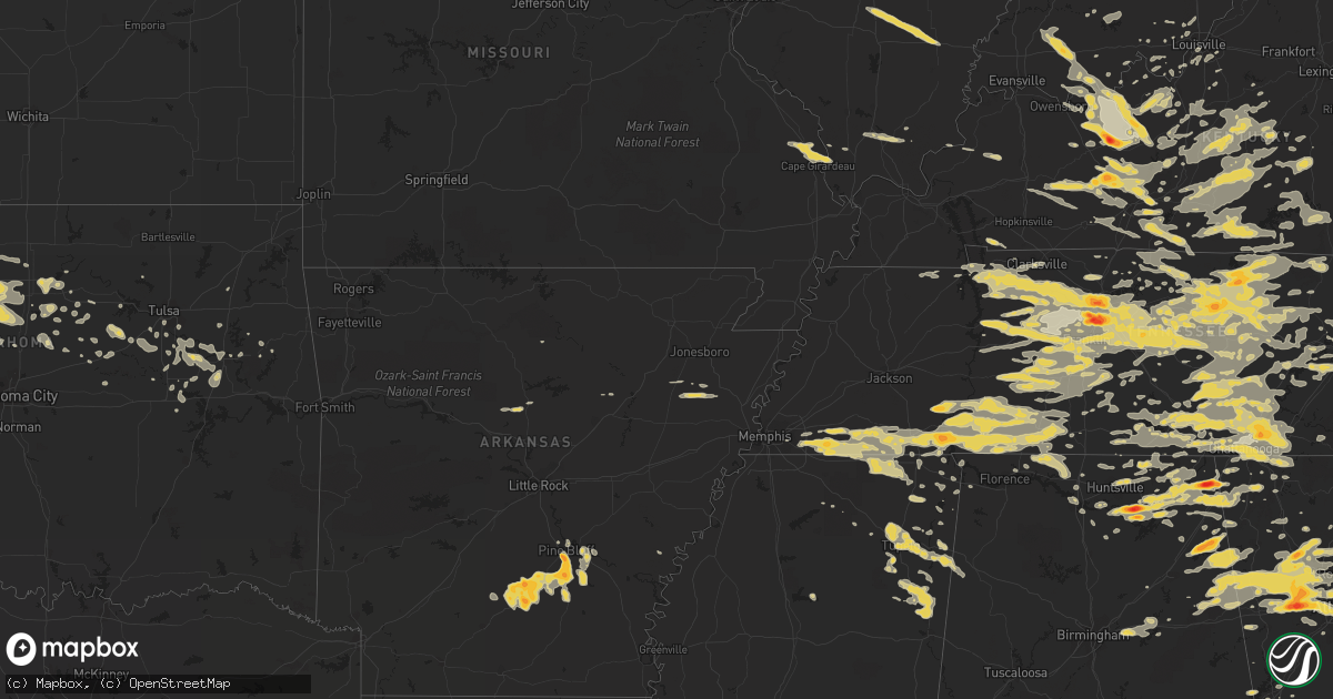
Hail Map on June 15, 2011
Get this storm
June 15 map
$229
one time, instant access
Download today. No call, no setup
Keep the $229
Bought the map and want the full workflow? Apply the entire $229 to a subscription within 7 days. None of it is wasted.
Every map, not just this one
This buys you this map. Subscription and you get every map we run, in the markets you choose from a few cities to whole states to nationwide. Plus real-time alerts the moment a storm fires.
Contact data
Name, contact info, occupancy, even credit band for addresses in the footprint. You go from where it hit to who to call.
Become the source they trust
Unlimited branding weather history reports on demand. You already have the documented answer ready for the property owner, and you are the one who showed up with it.
Property data and RoofTrace estimates
Pull up any address you have got, its value and the exact code rules for that jurisdiction, straight from One Click Code. Then RoofTrace estimates the squares, pitch, and roof value, priced the way you price.
States Impacted by Hail Map on June 15, 2011
Storm reports
Kentucky
| Date | Description |
|---|---|
| 06/15/20116:46 PM CDT | 18 inch diameter tree knocked down along with power lines in northern hancock county |
| 06/15/20116:45 PM CDT | Reported quarter to half dollar size hail |
| 06/15/20116:33 PM CDT | Report of dime to quarter size hail |
| 06/15/20116:03 PM CDT | Quarter size hail reported at the intersection of hwys 139 and 164. |
| 06/15/20116:00 PM CDT | Occurred between 652pm and 707pm |
| 06/15/20115:55 PM CDT | Report relayed from public of golf ball size hail |
| 06/15/20115:55 PM CDT | Late report...straight-line wind damage near the intersection of hwy 171 and kenwood lane. One barn with 6x6 poles snapped and roof blown 100 yards away. Several trees |
| 06/15/20115:53 PM CDT | Quater inch hail and wind gusts 45 mph with the storm. |
| 06/15/20115:27 PM CDT | A few trees and powerlines down on ridge bay drive and gold point circle. Reported by dispatch. |
| 06/15/20115:03 PM CDT | Occurred between 548pm and 603pm |
| 06/15/20114:50 PM CDT | Spotter reported golf ball to tennis ball size hail along the ohio-grayson county border |
| 06/15/20114:22 PM CDT | Spotter estimated hail to be about half dollar sized |
| 06/15/20114:15 PM CDT | A local report indicates 1.00 inch wind near WHITESVILLE |
| 06/15/201111:53 AM CDT | One tree down on glen-carin road. |
| 06/15/201111:10 AM CDT | Power lines down near sulphur well. |
| 06/15/201110:48 AM CDT | Tree downed at us 68 and claunch road. |
| 06/14/20118:13 PM CDT | Quarter size hail reported |
| 06/14/20117:53 PM CDT | A local report indicates 1.50 inch wind near MCDANIELS |
| 06/14/20117:38 PM CDT | Report relayed of quarter size hail |
| 06/14/20117:20 PM CDT | 2 trees down |
| 06/14/20117:17 PM CDT | Nickel to quarter size hail reported |
Mississippi
| Date | Description |
|---|---|
| 06/15/20116:55 PM CDT | A local report indicates 1.00 inch wind near WALNUT |
| 06/15/20116:38 PM CDT | Trees down...shigles off of houses...and a metal porch was blown over due to straight line winds. |
| 06/14/20117:26 PM CDT | Hail lasted about 2 minutes and was 1 inch hail. |
| 06/14/20117:10 PM CDT | Hail reported on n hwy 365 near burnsville |
| 06/14/20117:05 PM CDT | Quarter size hail at the intersection of highways 45 and 72. |
Georgia
| Date | Description |
|---|---|
| 06/15/20116:52 PM CDT | Many reports of hail around the county. Largest estimated at golfball size. |
| 06/15/20116:38 PM CDT | 911 call center relayed a report of numerous trees down across the county. |
| 06/15/20116:30 PM CDT | Public reported quarter size hail just south of sandy springs. |
| 06/15/20116:00 PM CDT | A local report indicates 1.50 inch wind near 3 E DOUGLASVILLE |
| 06/15/20115:55 PM CDT | A local report indicates 2.50 inch wind near DOUGLASVILLE |
| 06/15/20115:55 PM CDT | A local report indicates 1.00 inch wind near 3 E HIRAM |
| 06/15/20115:55 PM CDT | A local report indicates 1.75 inch wind near 4 W DOUGLASVILLE |
| 06/15/20115:50 PM CDT | A local report indicates 1.00 inch wind near 2 SW VILLA RICA |
| 06/15/20115:50 PM CDT | A local report indicates 1.25 inch wind near 4 W DOUGLASVILLE |
| 06/15/20115:40 PM CDT | A local report indicates 1.75 inch wind near HIRAM |
| 06/15/20115:24 PM CDT | A local report indicates 1.00 inch wind near 2 ENE NEW HOPE |
| 06/15/20115:22 PM CDT | A local report indicates 1.00 inch wind near CUMMING |
| 06/15/20115:15 PM CDT | A local report indicates 1.25 inch wind near KENNESAW |
| 06/15/20115:10 PM CDT | A local report indicates 1.00 inch wind near 6 NW MARIETTA |
| 06/15/20115:10 PM CDT | Forsyth county 911 relayed reports of 15-20 downed trees in and around forsyth. 15-20 powerlines were also reported downed...with 3-4 transformer fires. Several house f |
| 06/15/20115:00 PM CDT | A local report indicates 1.25 inch wind near 5 S ACWORTH |
| 06/15/20115:00 PM CDT | A local report indicates 1.00 inch wind near CEDARTOWN |
| 06/15/20114:59 PM CDT | A local report indicates 1.25 inch wind near 7 SW ACWORTH |
| 06/15/20114:50 PM CDT | A local report indicates 1.25 inch wind near 8 W CEDARTOWN |
| 06/15/20112:55 PM CDT | Pilot truck stop in rising fawn reported quarter sized hail fell with the storm. |
| 06/15/201112:40 PM CDT | Trained storm spotter reported quarter sized hail over catoosa county near the tennessee state line. |
| 06/15/201112:35 PM CDT | A local report indicates 1.00 inch wind near ROSSVILLE |
| 06/15/20111:35 AM CDT | Numerous areas of tree and limb damage near the intersection of sea island road and frederica road. One pickup truck had a damaged back bed from a 12 inch diameter bran |
| 06/15/20111:10 AM CDT | Emergency management reported several trees down across northeastern brantley county. Time is estimated from radar. |
| 06/15/201112:44 AM CDT | Emergency management reported a tree down on broadhurst road. Time is estimated from radar. |
| 06/15/201112:02 AM CDT | Light pole snapped off at the top. |
| 06/14/201111:54 PM CDT | Law enforcement reported a tree down on road near private branch church off hwy 301. |
| 06/14/201111:42 PM CDT | Muscogee county 911 relayed reports of a downed tree and a downed powerline in columbus. |
| 06/14/201111:30 PM CDT | Wheeler county emergency management relayed reports of several downed trees on and around hwy 19. |
| 06/14/201111:30 PM CDT | Tree down in glennville |
| 06/14/201111:27 PM CDT | 9-inch tree limbs down with large tree limb on car. Electricity out in the area. Dime to penny sized hail also reported. |
| 06/14/201111:15 PM CDT | Macon county 911 reports 2-3 downed trees. |
| 06/14/201111:10 PM CDT | Webster county 911 relayed a report of a downed tree. |
| 06/14/201111:03 PM CDT | A local report indicates 1.00 inch wind near 6 NW WORKMORE |
| 06/14/201111:00 PM CDT | Laurens county 911 relayed reports of 3-4 downed trees and a few downed powerlines due to winds. |
| 06/14/201111:00 PM CDT | Houston county 911 relayed reports of 10 downed trees in the county. |
| 06/14/201111:00 PM CDT | Houston county 911 relayed reports of 10 downed trees in the county. |
| 06/14/201111:00 PM CDT | Tree down on highway 292 |
| 06/14/201110:56 PM CDT | 1 large oak tree blown down in kathleen. |
| 06/14/201110:55 PM CDT | Schley county 911 reports 2-3 downed trees in ellaville. |
| 06/14/201110:50 PM CDT | Montgomery county emergency manager reports 2 downed trees on fire tower road. |
| 06/14/201110:50 PM CDT | Cobb county emergency management reports a dozen down trees. |
| 06/14/201110:50 PM CDT | Cobb county emergency management reports a dozen down trees. |
| 06/14/201110:48 PM CDT | Public reported large oak tree down across hwy 292. |
| 06/14/201110:45 PM CDT | Report of 1 tree down in higgston. |
| 06/14/201110:30 PM CDT | A local report indicates 1.00 inch wind near CLINCHFIELD |
| 06/14/201110:30 PM CDT | A local report indicates 1.00 inch wind near 3 ENE HAWKINSVILLE |
| 06/14/201110:25 PM CDT | 911 center relayed report of trees down on coley boyd road. |
| 06/14/201110:20 PM CDT | 911 center relayed report of downed power lines along mud road. |
| 06/14/201110:17 PM CDT | Houston county 911 relayed reports of 5 downed trees. |
| 06/14/201110:16 PM CDT | A local report indicates 1.75 inch wind near HIRAM |
| 06/14/201110:11 PM CDT | 911 center relayed report of downed power lines along highway 80. |
| 06/14/201110:07 PM CDT | 911 center relayed report of trees and power lines down on zettwell rd. |
| 06/14/201110:05 PM CDT | A local report indicates 1.75 inch wind near HIRAM |
| 06/14/201110:04 PM CDT | Crawford county 911 relayed reports of 6 downed trees. |
| 06/14/201110:03 PM CDT | A local report indicates 1.75 inch wind near 4 NNW SOPERTON |
| 06/14/201110:02 PM CDT | 911 center relayed report of trees down on old dill road. |
| 06/14/20119:55 PM CDT | Report of several large trees down in yard on clito road. |
| 06/14/20119:55 PM CDT | A local report indicates 1.00 inch wind near 5 NW WORKMORE |
| 06/14/20119:39 PM CDT | Johnson county fire department relayed a report of a few trees down in the scott area. Also a nursing home was struck by lightning in scott. |
| 06/14/20119:31 PM CDT | Reported near the intersection of us 82 and fussell road |
| 06/14/20119:20 PM CDT | 911 reports several trees and several powerlines down across northern portions of the county. |
| 06/14/20119:20 PM CDT | 2 trees down and 1 power line down in north alcovy area. |
| 06/14/20119:10 PM CDT | 3 trees down across south newton county. |
| 06/14/20119:00 PM CDT | 4 trees and 1 power line down |
| 06/14/20118:49 PM CDT | Trees down thompson bridge road area |
| 06/14/20118:45 PM CDT | A local report indicates 1.00 inch wind near 4 NNW WALNUT GROVE |
| 06/14/20118:35 PM CDT | Trees down at hwys 23 and 80 |
| 06/14/20118:30 PM CDT | Trees and power lines down |
| 06/14/20118:24 PM CDT | Jefferson county 911 relayed a report of at least six trees down in the the county. Most of the downed trees are located in wrens. |
| 06/14/20118:22 PM CDT | Numerous trees and powerlines down. One tree on a car. Power out across the county. |
| 06/14/20118:22 PM CDT | 3 trees down across south newton county. |
| 06/14/20118:20 PM CDT | A local report indicates 1.00 inch wind near CEDARTOWN |
| 06/14/20118:15 PM CDT | Hail up to quarter size reported in the isabella area |
| 06/14/20118:12 PM CDT | Wind gust of 58 knots..or 67 mph...measured at augusta bush field |
| 06/14/20118:10 PM CDT | Trees and powerlines down countywide |
| 06/14/20118:10 PM CDT | A local report indicates 1.00 inch wind near KENNESAW |
| 06/14/20118:05 PM CDT | Reported near us 27 just north of colquitt |
| 06/14/20118:01 PM CDT | Morgan county 911 relayed a report of a few trees down in the county. Dispatch also reports power outages in four parts of the county. |
| 06/14/20118:00 PM CDT | Trees down near soap creek bridge on indian road near us 220. |
| 06/14/20118:00 PM CDT | Numerous trees and powerlines reported down across northern sections of the county. |
| 06/14/20117:53 PM CDT | A local report indicates 1.00 inch wind near CARTERSVILLE |
| 06/14/20117:52 PM CDT | Trees down. |
| 06/14/20117:50 PM CDT | A local report indicates 1.75 inch wind near CARTERSVILLE |
| 06/14/20117:43 PM CDT | A local report indicates 1.00 inch wind near 2 WNW SUTALLEE |
| 06/14/20117:40 PM CDT | Trees and powerlines down in and around lincolnton |
| 06/14/20117:38 PM CDT | A local report indicates 1.00 inch wind near 1 S CANTON |
| 06/14/20117:33 PM CDT | A local report indicates 1.25 inch wind near COVINGTON |
South Carolina
| Date | Description |
|---|---|
| 06/15/20116:54 PM CDT | Multiple trees down. Time estimated by radar. |
| 06/15/20116:53 PM CDT | Tree limbs and powerlines down in whitmire |
| 06/15/20116:45 PM CDT | Trees and limbs down in santuck. |
| 06/15/20116:30 PM CDT | Multiple trees down blocking roads |
| 06/15/20116:06 PM CDT | Numerous trees down in and around the city of anderson. |
| 06/15/20116:03 PM CDT | Multiple trees down. |
| 06/15/20116:00 PM CDT | Fence blown down...skirting blown off mobile home...roof peeled...and tree damage. |
| 06/15/20115:56 PM CDT | Multiple trees down at gsp airport |
| 06/15/20115:55 PM CDT | Up to half dollar sized hail in reidville. |
| 06/15/20115:55 PM CDT | Multiple trees down |
| 06/15/20115:55 PM CDT | Numerous homes with shingles removed and siding ripped off along reidville road. At least 100 homes affected. Similar damage in lyman and other parts of the county. |
| 06/15/20115:53 PM CDT | One inch hail |
| 06/15/20115:52 PM CDT | 8 inch limbs down on sc 357 near stewarts estate |
| 06/15/20115:50 PM CDT | Hail larger than one inch in diameter reported on ellison circle. |
| 06/15/20115:50 PM CDT | At least 9 oak trees uprooted in rolling greens village. |
| 06/15/20115:48 PM CDT | Kgsp asos |
| 06/15/20115:48 PM CDT | Quarter sized hail reported near doppler drive |
| 06/15/20115:48 PM CDT | Wind gust to 60 mph reported by asos at greenville-spartanburg airport |
| 06/15/20115:47 PM CDT | Numerous trees down along ellison road and ellison circle. An area on ellison circle where the tops of a few trees were taken off. |
| 06/15/20115:47 PM CDT | A large tree fell on a house near the intersection of hammett bridge road and south buncombe road. Visible damage to the house as the tree hit the corner and was lying |
| 06/15/20115:37 PM CDT | Trees down at us 276 and bates crossing road |
| 06/15/20115:37 PM CDT | Golf ball sized hail reported near lake robinson |
| 06/15/20115:35 PM CDT | Trees down at lake cunningham...tree on house |
| 06/14/201111:18 PM CDT | Tree down on a house on fort johnson road. Time estimated based on radar. |
| 06/14/201111:15 PM CDT | Public reported estimated 70mph wind gust. Several large trees down and blown transformers on dorchester road. |
| 06/14/201111:05 PM CDT | Spotter reported a tree down in a wooded area. 55 mph wind gust. |
| 06/14/201111:00 PM CDT | Public reported large trees down. |
| 06/14/201110:57 PM CDT | Report of 6 inch tree branches blown down. |
| 06/14/201110:45 PM CDT | Public report of quarter size hail and large oak tree down on hudson mills road. |
| 06/14/201110:45 PM CDT | Public report of quarter size hail and large oak tree down on hudson mills road. |
| 06/14/201110:25 PM CDT | Off duty nws employee reported a large 10-12 foot diameter pine tree down on jacksonboro road |
| 06/14/201110:15 PM CDT | Public reported power lines down and on fire along hwy 21 towards beaufort...in the pristine area. |
| 06/14/20119:45 PM CDT | 25 trees down on property. Tractor shed damaged. |
| 06/14/20119:30 PM CDT | Trees down countywide |
| 06/14/20119:15 PM CDT | Trees and powerlines down |
| 06/14/20119:09 PM CDT | Large trees down at hwy 321 and williams rd. Time estimated by radar. |
| 06/14/20119:06 PM CDT | Sc highway patrol reported a tree down in the roadway at sc 3 and us 278. |
| 06/14/20119:00 PM CDT | South carolina highway patrol reported a tree down in the roadway at sc 300 and emerald lane |
| 06/14/20118:43 PM CDT | South carolina highway patrol reported trees down at furman field road and highway 441. |
| 06/14/20118:38 PM CDT | Trees and power lines down. |
| 06/14/20118:34 PM CDT | South carolina highway patrol reported trees down at murph mill road and sweetwater lane. |
| 06/14/20118:30 PM CDT | Trees down on bull swamp road |
| 06/14/20118:30 PM CDT | Trees down on bull swamp road |
| 06/14/20118:30 PM CDT | Power line down on goodland drive. |
| 06/14/20118:30 PM CDT | Trees down on dr. Boyleton road |
| 06/14/20118:30 PM CDT | Sc highway patrol reported a tree down in the roadway at murph mill road and sweetwater lane. |
| 06/14/20118:28 PM CDT | Trees and power lines down. Atomic road. |
| 06/14/20118:24 PM CDT | Wind gust measured at 53 knots...or 61 mph...at mcentire air national guard base |
| 06/14/20118:15 PM CDT | Tree in roadway...mcmillian road and sandbar ferry road |
| 06/14/20118:15 PM CDT | Sc highway patrol reported a tree in roadway at silver bluff landing off old jackson road. |
| 06/14/20118:10 PM CDT | Trees and powerlines down around lexington |
| 06/14/20118:10 PM CDT | Numerous trees down in the northeast columbia area. Reported by schp. |
| 06/14/20118:05 PM CDT | Trees and powerlines down around irmo |
| 06/14/20118:02 PM CDT | Trees and powerlines down around blythewood |
| 06/14/20118:00 PM CDT | Trees down in plum branch area |
| 06/14/20118:00 PM CDT | Trees and powerlines down around chapin |
| 06/14/20117:45 PM CDT | Trees and powerlines down northern end of mccormick county around mt carmel |
| 06/14/20117:30 PM CDT | Multiple trees down reported county wide. |
| 06/14/20117:23 PM CDT | Many trees down western part of fairfield county. |
| 06/14/20117:19 PM CDT | Time estimated by radar. |
| 06/14/20117:05 PM CDT | Several large limbs down. |
| 06/14/20117:03 PM CDT | Numerous trees and powerlines down and trees on cars newberry to whitmire |
| 06/14/20117:00 PM CDT | Local grocery store employee saw many large tree limbs down across the area from the storm. |
Oklahoma
| Date | Description |
|---|---|
| 06/15/20115:54 AM CDT | A local report indicates 58 MPH wind near 5 SSE HASKELL |
| 06/15/20114:50 AM CDT | A local report indicates 66 MPH wind near 3 NNE SPARKS |
| 06/15/20114:45 AM CDT | A local report indicates 60 MPH wind near DRUMRIGHT |
| 06/15/20113:25 AM CDT | A local report indicates 59 MPH wind near 7 SSE RED ROCK |
| 06/15/20113:05 AM CDT | A local report indicates 65 MPH wind near 1 SW MEDFORD |
| 06/15/20113:04 AM CDT | A local report indicates 60 MPH wind near 4 SE BILLINGS |
| 06/15/20112:30 AM CDT | Resulted in power outages in kremlin. |
| 06/15/201112:30 AM CDT | A local report indicates 1.00 inch wind near 1 NE TANGIER |
| 06/15/201112:25 AM CDT | A trained spotter and kwtv-9 reported up to half dollar size hail on highway 412. A large tree limb was also blown down blocking the west bound lane of highway 412. |
| 06/14/201111:38 PM CDT | A local report indicates 1.75 inch wind near 12 S BUFFALO |
Illinois
| Date | Description |
|---|---|
| 06/15/20116:18 PM CDT | Tornado touched down on the bishop ford expressway just north of 159th street and moved east to near 158th place and paxton road. The tornado was rated ef0 and had a pa |
| 06/15/20113:30 PM CDT | Two barns destroyed |
| 06/15/20112:45 PM CDT | Reported by police department. |
| 06/14/20118:23 PM CDT | Shingles off bank and metal roofing off building in town. |
| 06/14/20118:21 PM CDT | Tornado still on ground. 72 mph wind gust recorded. Powerlines down with power flashes. Tornado possibly lifting visually. |
| 06/14/20118:19 PM CDT | Tornado still on ground. Debris on il rt 88. At albany exit. |
| 06/14/20118:19 PM CDT | Tornado still on ground. Debris on il rt 88 at albany exit. |
| 06/14/20118:15 PM CDT | Tornado on ground 1 west albany exit on rt 88. Roof off barn. |
| 06/14/20118:15 PM CDT | Tornado on ground 1 west albany exit on rt 88. Roof off barn. |
| 06/14/20118:12 PM CDT | Power pole snapped off on mohawk road. |
Nebraska
| Date | Description |
|---|---|
| 06/15/20115:00 AM CDT | A local report indicates 1.75 inch wind near 15 S NORTH PLATTE |
Kansas
| Date | Description |
|---|---|
| 06/15/20116:37 PM CDT | A local report indicates 1.25 inch wind near 10 SSE OBERLIN |
| 06/15/20116:33 PM CDT | Encountered hail at intersection of ks highway 9 and 23. |
| 06/15/20116:30 PM CDT | A local report indicates 1.75 inch wind near 2 S DRESDEN |
| 06/15/20116:24 PM CDT | Large hail fell for approximately 3 minutes. |
| 06/15/20115:50 PM CDT | A local report indicates 1.25 inch wind near 21 N MARIENTHAL |
| 06/14/201110:10 PM CDT | Tree branches of 4 to 5 inches in diameter were broken and some power poles were down. |
| 06/14/20118:55 PM CDT | The wind was measured with a hand held anemometer. |
| 06/14/20118:45 PM CDT | A local report indicates 70 MPH wind near 5 NNW THE HAGGARD ELEV |
| 06/14/20118:30 PM CDT | The observer reported extensive blowing dust with the high winds. |
Alabama
| Date | Description |
|---|---|
| 06/15/20114:30 PM CDT | Quarter size hail in the community of forney. |
| 06/15/20113:07 PM CDT | Quarter size hail reported on county road 44. |
| 06/15/20113:03 PM CDT | Golf ball size hail reported along county road 82. |
| 06/15/20112:55 PM CDT | A local report indicates 1.75 inch wind near 5 NE IDER |
| 06/15/20112:53 PM CDT | On county rd 778 near ider. Golfball to baseball sized hail reported. |
| 06/15/20112:53 PM CDT | On county rd 778 near ider. Golfball to baseball sized hail reported. |
| 06/15/20112:52 PM CDT | Hail falling on county road 11. |
| 06/15/20112:38 PM CDT | One inch diameter hail was reported. |
| 06/15/20112:36 PM CDT | Some car windshields were reported shattered. |
| 06/15/20112:13 PM CDT | A local report indicates 1.00 inch wind near GRANT |
| 06/15/20112:00 PM CDT | One inch diamter hail was reported. |
| 06/15/20111:49 PM CDT | A local report indicates 1.75 inch wind near NEW HOPE |
| 06/15/20111:45 PM CDT | A local report indicates 1.00 inch wind near 2 E NEW HOPE |
| 06/15/20111:45 PM CDT | A local report indicates 2.50 inch wind near NEW HOPE |
| 06/15/20111:43 PM CDT | A local report indicates 1.00 inch wind near 1 SE OWENS CROSSROADS |
| 06/15/20111:40 PM CDT | A local report indicates 1.00 inch wind near SSW NEW HOPE |
| 06/15/201111:34 AM CDT | On ryland pike. Hail lasted for 2 minutes. |
| 06/14/201110:24 PM CDT | A local report indicates 1.00 inch wind near 3 NW PELL CITY |
| 06/14/20118:40 PM CDT | Quarter size hail reported. |
| 06/14/20118:28 PM CDT | A tree was blown down and the intersection of cr 46 and cr 20. |
| 06/14/20118:15 PM CDT | Trees blown down in downtown athens on lucas ferry road. |
| 06/14/20118:15 PM CDT | Quarter size hail was reported on lucas ferry road. |
| 06/14/20118:09 PM CDT | Tree down on powerlines on county road 57 near county road 697. |
| 06/14/20118:08 PM CDT | Quarter size hail reported |
| 06/14/20118:07 PM CDT | Quarter size hail reported |
| 06/14/20118:02 PM CDT | A tree was blown down on cr 116. |
| 06/14/20117:58 PM CDT | A tree was blown down on cr 52 one half of a mile from highway 75. |
| 06/14/20117:56 PM CDT | A tree was blown down near cr 289 and cr 307 |
| 06/14/20117:54 PM CDT | A tree was blown down on cr 307. |
| 06/14/20117:40 PM CDT | A wind gust to 51 knots was reported at the muscle shoals asos site. |
| 06/14/20117:26 PM CDT | Quarter size hail reported. |
| 06/14/20117:25 PM CDT | A tree was blown down on a house. |
Utah
| Date | Description |
|---|---|
| 06/14/20119:07 PM CDT | A local report indicates 58 MPH wind near DELTA |
Indiana
| Date | Description |
|---|---|
| 06/15/20116:23 PM CDT | Broken electric pole. Missing road signs at intersection of state highway 62 and u.s. Highway 231. Cable transmission tower blown over. |
| 06/15/20116:07 PM CDT | Damage to home and porch roofs at one residence. Damage to one auto hit by large tree branches. Damage to electrical weather head. |
Florida
| Date | Description |
|---|---|
| 06/15/20116:50 PM CDT | 911 call center reported trees down in ocala. |
| 06/15/20116:45 PM CDT | Measured at hamilton harbor yacht club in naples. |
| 06/15/20116:45 PM CDT | Measured on roof of collier county emergency operations center. Approximate height of instrument is 60 feet above ground. Surface winds likely in 70-80 mph range. |
| 06/15/20116:40 PM CDT | Measured at golden gate fire station 70. |
| 06/15/20116:35 PM CDT | Measured at golden gate fire station 71. |
| 06/15/20116:30 PM CDT | 1.5 to 2 feet in diameter pines trees were reported down in the immokalee area. Trees were also blown down and onto trailers and a car causing damage. |
| 06/15/20116:10 PM CDT | An oak and palm trees were reported down along highway 27 near the tropical market in clewiston. |
| 06/15/20115:20 PM CDT | Trees down in the hickory groove area northeast of madison and south-southeast of pinetta with possible roof damage. Trampoline also wrapped around a tree. |
| 06/15/20114:50 PM CDT | Multiple trees down. Trees approx 3-4 inches in diameter and 7-8 ft tall. On martin hwy between fox brown rd and allapattah rd. Time estimated by radar. |
| 06/15/20114:45 PM CDT | Public report relayed through sheriffs office of golf ball size hail near martin hwy at fox brown rd. |
| 06/15/20114:03 PM CDT | A local report indicates 1.00 inch wind near 5 W CARLTON |
| 06/15/20112:55 PM CDT | Trained spotter reported quarter size hail in lake alfred. |
| 06/15/20112:50 PM CDT | Asos reported 55 kt...63 mph wind gust. |
| 06/15/20112:45 PM CDT | Public reported quarter size hail in auburndale near hwy 33 and i-4 |
| 06/15/20112:45 PM CDT | Trained spotter report of penny to quarter size hail 4 miles north of dunnellon. |
| 06/15/20112:31 PM CDT | Quarter-sized hail in the poinsett shores subdivision. |
| 06/15/20112:10 PM CDT | Ksc 54 foot tower number 1605 measured 58 kt/67 mph wind gust. |
| 06/15/20111:52 PM CDT | Hail up to quarter-sized with estimated winds of 50-55 mph. |
| 06/15/20111:33 PM CDT | Trained spotter reported dime to quarter size hail. |
| 06/15/20111:00 PM CDT | Sheriffs office reported quarter sized hail ongoing since 2 pm |
| 06/15/201112:53 PM CDT | Spotter reported half to one inch hail falling in downtown inverness. |
| 06/14/20118:56 PM CDT | Thunderstorm winds blew down trees along 2750 se 49th avenue. |
| 06/14/20118:47 PM CDT | Trees were blown down along 10896 se 131st lane. |
| 06/14/20118:35 PM CDT | Scattered trees and tree limbs were blown down onto power lines across eastern alachua and norther marion county. The time of damage was based on radar imagery. |
| 06/14/20117:55 PM CDT | Clay electric utility company reported scattered trees and large limbs down on powerlines. Damage extended from southern bradford into northeast alachua. |
| 06/14/20117:35 PM CDT | Thunderstorm winds blew down trees along 2750 se 49th avenue. The time of damage was based on radar. |
| 06/14/20117:25 PM CDT | Spotter reported golf ball sized hail ssw of worthington springs. |
| 06/14/20117:25 PM CDT | A local report indicates 1.75 inch wind near N WORTHINGTON SPRINGS |
| 06/14/20117:25 PM CDT | A local report indicates 1.75 inch wind near 3 N WORTHINGTON SPRINGS |
| 06/14/20117:20 PM CDT | Clay electric utility company reported scattered trees blown down into powerlines across western putnam and southeast alachua counties. Tree damage was also noted in ma |
| 06/14/20117:10 PM CDT | Measured at isle of capri fire station. |
| 06/14/20117:04 PM CDT | A local report indicates 62 MPH wind near BELLE MEADE |
| 06/14/20117:00 PM CDT | Numerous reports of tree branches and trees down across the naples-golden gate estates-immokalee areas. Power lines reported down throughout naples and naples metro. Ra |
| 06/14/20117:00 PM CDT | Trees were blown down along 10896 se 131st lane. The time of damage was based on radar. |
Missouri
| Date | Description |
|---|---|
| 06/15/20113:15 PM CDT | Late report...wind gusts estimated 70 mph. Dime size hail reported with this storm. Bent flag pole. Event occurred near country club along route 177 on north side of to |
New York
| Date | Description |
|---|---|
| 06/15/20112:42 PM CDT | A local report indicates 1.00 inch wind near EPHRATAH |
Arkansas
| Date | Description |
|---|---|
| 06/15/201111:05 AM CDT | Tree limbs downed...along with half inch hail covering the ground. |
| 06/14/201110:26 PM CDT | Golfball sized hail was reported by a sheriffs deputy at the highway 79 south junction in fordyce. |
| 06/14/20119:45 PM CDT | The dallas county sheriff reported golfball sized hail at ivan. |
| 06/14/20119:13 PM CDT | A local report indicates 1.00 inch wind near 2 NE SALINE |
| 06/14/20118:54 PM CDT | A local report indicates 1.00 inch wind near 6 NW RISON |
| 06/14/20118:35 PM CDT | A local report indicates 1.00 inch wind near 1 N WOODLAWN |
| 06/14/20118:25 PM CDT | Golfball sized hail damaged a vehicle. |
| 06/14/20118:15 PM CDT | A local report indicates 1.00 inch wind near STAR CITY |
| 06/14/20118:08 PM CDT | A local report indicates 1.00 inch wind near STAR CITY |
| 06/14/20118:00 PM CDT | A local report indicates 1.00 inch wind near 1 S PINEBERGEN |
| 06/14/20117:40 PM CDT | Quarter to golfball sized hail was falling in southern jefferson county on highway 63 southeast of watsons chapel. |
Montana
| Date | Description |
|---|---|
| 06/14/201111:09 PM CDT | A local report indicates 63 MPH wind near 3 WNW MILES CITY |
| 06/14/201111:05 PM CDT | Cow creek raws |
| 06/14/201110:53 PM CDT | A local report indicates 70 MPH wind near 11 N BRANDENBERG |
| 06/14/201110:47 PM CDT | Sweeney creek dot |
| 06/14/201110:35 PM CDT | Badger peak raws |
| 06/14/201110:30 PM CDT | At the town pump gas station |
| 06/14/20119:35 PM CDT | Power lines down in hardin |
| 06/14/20119:30 PM CDT | A local report indicates 81 MPH wind near 1 ENE HARDIN |
| 06/14/20119:30 PM CDT | Winds blew over several fences in town and broke tree limbs. Roof to the western motel was blown off in addition to several large trees being uprooted and many power li |
| 06/14/20119:30 PM CDT | Tops of trees and 8 inch limbs broken off |
| 06/14/20119:08 PM CDT | A local report indicates 1.00 inch wind near 3 WSW WORDEN |
| 06/14/20118:45 PM CDT | Numerous reports of large trees and branches down across billings causing power outages. Downed trees and branches have also fallen on several vehicles. One particular |
| 06/14/20118:37 PM CDT | A local report indicates 58 MPH wind near BILLINGS |
| 06/14/20118:36 PM CDT | 30 to 40 foot live cottonwood tree snapped off at pioneer park. |
Iowa
| Date | Description |
|---|---|
| 06/15/20116:55 PM CDT | A local report indicates 1.00 inch wind near PEOSTA |
| 06/14/20117:21 PM CDT | Quarter hail continues through 721 pm. Heavy rain has produced minor street flooding as well. |
| 06/14/20117:18 PM CDT | And heavy rain. |
Tennessee
| Date | Description |
|---|---|
| 06/15/20116:55 PM CDT | Quarter size hail 12 miles south of lawrenceburg. |
| 06/15/20116:50 PM CDT | Trees and power lines down just southwest of town of counce near pickwick landing. |
| 06/15/20116:45 PM CDT | A local report indicates 1.50 inch wind near MILLEDGEVILLE |
| 06/15/20116:43 PM CDT | Golf ball hail reported in the town of nixon. |
| 06/15/20116:20 PM CDT | A few trees and powerlines down on branston road and tallant road between collegedale and ooltewah. Reported by dispatch. |
| 06/15/20116:20 PM CDT | Thunderstorm wind gust of 60 mph and half inch hail in far southwest dickson county. |
| 06/15/20115:47 PM CDT | Half dollar size hail in waverly. |
| 06/15/20115:46 PM CDT | One tree down on highway 108. Reported by dispatch. |
| 06/15/20115:45 PM CDT | Several trees and powerlines down on highway 127 near miller cove road. Reported by dispatch. |
| 06/15/20115:37 PM CDT | Trees reported down across the county. |
| 06/15/20115:30 PM CDT | Trees were blown down on highway 55. |
| 06/15/20115:20 PM CDT | Several trees and powerlines down in lone oak. Reported by ema. |
| 06/15/20115:18 PM CDT | Quarter sized hail in lone oak. Reported by ema. |
| 06/15/20115:16 PM CDT | Trees were reported down on shelbyville highway and lynchburg highway. |
| 06/15/20115:07 PM CDT | Several trees down in and around pikeville. One on highway 30e and another on college street. Reported by dispatch. |
| 06/15/20115:06 PM CDT | A local report indicates 1.00 inch wind near 3 NNE WINCHESTER |
| 06/15/20115:05 PM CDT | Hen egg sized hail in turtletown. Reported by spotter. |
| 06/15/20115:05 PM CDT | 2 inch hail at mccabe golf course in downtown nashville. |
| 06/15/20115:02 PM CDT | A local report indicates 1.00 inch wind near 4 SW DICKSON |
| 06/15/20114:58 PM CDT | Observed near charlotte pike and annex drive |
| 06/15/20114:55 PM CDT | A local report indicates 1.00 inch wind near 5 NE COLUMBIA |
| 06/15/20114:50 PM CDT | A local report indicates 1.00 inch wind near 6 SW DICKSON |
| 06/15/20114:40 PM CDT | Quarter sized hail in cleveland. Reported by spotter. |
| 06/15/20114:38 PM CDT | Numerous trees...powerlines and power poles down on highway 58 between highway 68 and highway 30. Reported by dispatch. |
| 06/15/20114:30 PM CDT | Golf ball sized hail on highway 58. Reported by spotter. |
| 06/15/20114:25 PM CDT | Observed at pelham |
| 06/15/20114:25 PM CDT | Roof blown off of a home in lawrenceburg. Trees down in and close to lawrenceburg. |
| 06/15/20114:23 PM CDT | Quarter to half dollar sized hail that the sequoyah nucler plantn and near hixson. |
| 06/15/20114:15 PM CDT | Trees down and some roof damage across western portion of the county. |
| 06/15/20114:05 PM CDT | Trees down across the southern portion of the county. |
| 06/15/20114:00 PM CDT | A local report indicates 1.25 inch wind near OLIVE HILL |
| 06/15/20113:50 PM CDT | Trees down across much of northwestern rutherford county. |
| 06/15/20113:45 PM CDT | A local report indicates 1.00 inch wind near 1 W DUNLAP |
| 06/15/20113:30 PM CDT | A local report indicates 1.00 inch wind near 2 NE SAVANNAH |
| 06/15/20113:30 PM CDT | Two trees were knocked down. |
| 06/15/20113:25 PM CDT | A local report indicates 1.00 inch wind near 1 W SALTILLO |
| 06/15/20113:22 PM CDT | A local report indicates 1.00 inch wind near 10 NW NASHVILLE |
| 06/15/20113:20 PM CDT | Hail occurred at harding road and interstate 24. |
| 06/15/20113:15 PM CDT | Observed at crieve hall in nashville |
| 06/15/20113:08 PM CDT | A local report indicates 1.00 inch wind near BELLE MEADE |
| 06/15/20113:08 PM CDT | Trees down across the county. |
| 06/15/20112:39 PM CDT | A local report indicates 1.00 inch wind near 4 NE HOHENWALD |
| 06/15/20112:16 PM CDT | A local report indicates 1.00 inch wind near 6 W CROSSVILLE |
| 06/15/20111:55 PM CDT | Hail was observed on lick creek road |
| 06/15/20111:15 PM CDT | A local report indicates 1.00 inch wind near 10 WSW SUNBRIGHT |
| 06/15/20111:15 PM CDT | Spotter believed winds caused by wet microburst. |
| 06/15/20111:00 PM CDT | One tree down on half moon road. Reported by dispatch. |
| 06/15/201112:50 PM CDT | Several trees down countywide. Reported by dispatch. |
| 06/15/201112:35 PM CDT | A local report indicates 1.00 inch wind near 5 SE CHATTANOOGA |
| 06/15/201112:22 PM CDT | A local report indicates 1.00 inch wind near 10 E MONTEREY |
| 06/15/201112:20 PM CDT | A local report indicates 1.00 inch wind near ROCKWOOD |
| 06/15/201112:18 PM CDT | Law enforcement rpt golf ball sized hail along hanging limb hwy in overton co. |
| 06/15/201112:05 PM CDT | Spotter rpt quarter sized hail |
| 06/15/201111:59 AM CDT | Quarter sized hail in double springs. |
| 06/15/201111:56 AM CDT | A local report indicates 1.75 inch wind near 5 N NASHVILLE |
| 06/15/201111:55 AM CDT | A local report indicates 1.00 inch wind near COOKEVILLE |
| 06/15/201111:50 AM CDT | One tree down on mt calvary rd. |
| 06/15/201110:59 AM CDT | Spotter rpt quarter sized hail. |
| 06/14/20119:50 PM CDT | Golfball size hail 2 miles west of cookeville. |
| 06/14/20119:10 PM CDT | Half dollar hail reported 3 miles north of cookeville. |
| 06/14/20119:10 PM CDT | Quarter size hail in pleasent shade. |
| 06/14/20117:45 PM CDT | Trees blown down and small hail in and near pulaski. |
| 06/14/20117:35 PM CDT | A local report indicates 60 MPH wind near LORETTO |
| 06/14/20117:22 PM CDT | Trees down and up to quarter size hail reported across southern portions of the county. |
| 06/14/20117:18 PM CDT | Half dollar hail reported 2 miles east of spring hill. |
North Carolina
| Date | Description |
|---|---|
| 06/15/20115:03 PM CDT | Multiple trees down 4 miles south of etowah. |
| 06/15/20114:38 PM CDT | Numerous trees down in the tusquittee road and downings creek road areas. Reported by dispatch. |
| 06/15/20114:35 PM CDT | Radio station in waynesville reported 60 to 70 mph winds. |
| 06/15/20114:34 PM CDT | Dime to golf ball sized hail in hayesville. Reported by dispatch. |
| 06/15/20114:30 PM CDT | Multiple trees down in franklin |
| 06/15/20114:30 PM CDT | Public report trees down near macon county airport |
| 06/15/20114:30 PM CDT | Multiple trees down |
| 06/15/20114:25 PM CDT | Numerous trees reported down in silva. |
| 06/15/20114:25 PM CDT | Multiple trees down off scotts creek rd. |
| 06/15/20114:21 PM CDT | Numerous trees and powerlines down. Reported by dispatch. |
| 06/15/20114:20 PM CDT | Sheriff reported trees down in northern jackson county. |
| 06/15/20114:03 PM CDT | Sheriff reported trees down in graham county. |
| 06/15/20113:45 PM CDT | Report of 1.5 inch hail in the city of candler. |
| 06/15/20113:05 PM CDT | A fire fighter in the area around the perserve at chesnut flats said there are trees down across haywood county with a few houses being hit by falling trees. Also power |
Wyoming
| Date | Description |
|---|---|
| 06/14/201111:32 PM CDT | Sheridan asos |
Cities Impacted by Hail Map on June 15, 2011
- Bearden, AR
- Star City, AR
- Thornton, AR
- New Edinburg, AR
- Kingsland, AR
- Ivan, AR
- Sparkman, AR
- Pine Bluff, AR
- Rison, AR
- Fordyce, AR
- Jasper, GA
- Columbus, MS
- Amory, MS
- West Point, MS
- Okolona, MS
- Aberdeen, MS
- Caledonia, MS
- Hamilton, MS
- Providence, KY
- Nebo, KY
- Buchanan, GA
- Sparta, TN
- Scottsville, KY
- Fountain Run, KY
- Sumterville, FL
- Bushnell, FL
- Colquitt, GA
- Curtis, NE
- Adairsville, GA
- Aline, OK
- Alva, OK
- Freedom, OK
- Carmen, OK
- Waynoka, OK
- Campbellsville, KY
- Winter Haven, FL
- Turtletown, TN
- Murphy, NC
- Copperhill, TN
- Okeechobee, FL
- Leesburg, AL
- Fort Payne, AL
- Cedar Bluff, AL
- Gaylesville, AL
- Collinsville, AL
- Soperton, GA
- Tarrytown, GA
- Smithville, MS
- Greenwood Springs, MS
- Tremont, MS
- Fowler, KS
- Minneola, KS
- Hudson, KY
- McDaniels, KY
- Leitchfield, KY
- Hardinsburg, KY
- Westview, KY
- Cartersville, GA
- Taylorsville, GA
- Pell City, AL
- Screven, GA
- Cuthbert, GA
- Richland, GA
- Lumpkin, GA
- Weston, GA
- Horse Branch, KY
- Olaton, KY
- Caneyville, KY
- Collinwood, TN
- McRae Helena, GA
- Lumber City, GA
- Hoschton, GA
- Jefferson, GA
- Winder, GA
- Belden, MS
- Blue Springs, MS
- Saltillo, MS
- Tupelo, MS
- Acworth, GA
- Bowling Green, KY
- Cedartown, GA
- Rockmart, GA
- Smiths Grove, KY
- Oakland, KY
- Jennings, KS
- Clayton, KS
- Sylvester, GA
- Crawfordville, FL
- Decherd, TN
- Monteagle, TN
- Sewanee, TN
- South Pittsburg, TN
- Hillsboro, TN
- Tracy City, TN
- Pelham, TN
- Sequatchie, TN
- Whitwell, TN
- Douglasville, GA
- Winston, GA
- Villa Rica, GA
- Scottsboro, AL
- Arapahoe, NE
- Edison, NE
- Leesburg, FL
- Webster, FL
- Lady Lake, FL
- Brooksville, FL
- Inverness, FL
- Coleman, FL
- Lake Panasoffkee, FL
- Wildwood, FL
- The Villages, FL
- Floral City, FL
- Hernando, FL
- Center Hill, FL
- Fruitland Park, FL
- Simpsonville, SC
- Micanopy, FL
- Hawthorne, FL
- Wellfleet, NE
- North Platte, NE
- Pine Mountain, GA
- French Lick, IN
- Covington, GA
- Jackson, GA
- Hilton Head Island, SC
- Canal Point, FL
- Eagleville, TN
- Rockvale, TN
- Shepherd, MT
- Newton, GA
- Camilla, GA
- Talbotton, GA
- Junction City, GA
- Edmonton, KY
- Center, KY
- Horse Cave, KY
- Glasgow, KY
- Knob Lick, KY
- Santa Fe, TN
- Lyles, TN
- Franklin, TN
- Primm Springs, TN
- Rentz, GA
- Dublin, GA
- Whigham, GA
- Climax, GA
- Huntsville, AL
- Brownsboro, AL
- Greenwood, SC
- Hodges, SC
- Abbeville, SC
- Ninety Six, SC
- Dickson, TN
- Spring City, TN
- Evensville, TN
- Elk Horn, KY
- Greensburg, KY
- Knifley, KY
- Hardyville, KY
- Columbia, KY
- Buffalo, OK
- Laverne, OK
- Englewood, KS
- May, OK
- Ashland, KS
- Rosston, OK
- Fargo, OK
- Fort Supply, OK
- Ensign, KS
- Rising Fawn, GA
- Trenton, GA
- Loganville, GA
- Immokalee, FL
- Naples, FL
- Lyons, GA
- Perry, OK
- Frostproof, FL
- Lynnville, TN
- Cornersville, TN
- Live Oak, FL
- Edson, KS
- Winona, KS
- Wallace, KS
- Parksville, KY
- Quincy, FL
- Guild, TN
- Bon Aqua, TN
- New Johnsonville, TN
- Thompsons Station, TN
- Fairview, TN
- Columbia, TN
- McEwen, TN
- Waverly, TN
- Nunnelly, TN
- Felda, FL
- Labelle, FL
- Palestine, IL
- Carlisle, IN
- Franklin, NC
- Groveland, FL
- Clermont, FL
- Winter Garden, FL
- Sturgis, KY
- Marion, KY
- Homosassa, FL
- Alpine, TN
- Rickman, TN
- Livingston, TN
- Cookeville, TN
- Hilham, TN
- Byrdstown, TN
- Monroe, TN
- Allons, TN
- Monterey, TN
- Mcminnville, TN
- Watkinsville, GA
- Kensington, KS
- Hartsville, TN
- Castalian Springs, TN
- Bethpage, TN
- Broken Arrow, OK
- Tulsa, OK
- Bartow, FL
- Lake Wales, FL
- Vine Grove, KY
- Radcliff, KY
- Rineyville, KY
- Fort Meade, FL
- Dodge City, KS
- Woodward, OK
- Ocala, FL
- Belleview, FL
- Summerfield, FL
- Ocklawaha, FL
- East Dublin, GA
- Brooklet, GA
- White Hall, AR
- Carthage, TN
- Brush Creek, TN
- Gordonsville, TN
- Pikeville, TN
- Chattanooga, TN
- Soddy Daisy, TN
- Harrison, TN
- Ooltewah, TN
- Hixson, TN
- Lebanon, KY
- Sapelo Island, GA
- Albany, GA
- Leesburg, GA
- Gradyville, KY
- Mentone, AL
- Valley Head, AL
- Henagar, AL
- Menlo, GA
- Smith Center, KS
- Lebanon, KS
- Spencer, TN
- Rock Island, TN
- Doyle, TN
- Quebeck, TN
- Cumming, GA
- Cusseta, GA
- Buena Vista, GA
- Irvington, KY
- Guston, KY
- Ekron, KY
- Garfield, KY
- Harned, KY
- Custer, KY
- Levant, KS
- Brewster, KS
- Sharon Springs, KS
- Auburndale, FL
- Lake Alfred, FL
- Davenport, FL
- Haines City, FL
- Eagle Lake, FL
- Polk City, FL
- Lakeland, FL
- Lewisburg, KY
- Crofton, KY
- Greenville, KY
- Sharon Grove, KY
- White Plains, KY
- Hopkinsville, KY
- Elkton, KY
- Canton, NC
- Pinehurst, GA
- Unadilla, GA
- Pisgah, AL
- Warne, NC
- Brasstown, NC
- Marble, NC
- Hayesville, NC
- Tallahassee, FL
- Monticello, FL
- Perry, FL
- Orleans, NE
- Alma, NE
- Stamford, NE
- Hawesville, KY
- Cannelton, IN
- Cloverport, KY
- Clarkson, KY
- Falls Of Rough, KY
- Jackson, MO
- Lancaster, TN
- Hickman, TN
- Liberty, TN
- Alexandria, TN
- College Grove, TN
- Spring Hill, TN
- Harriman, TN
- Pekin, IN
- Palmyra, IN
- Coleman, GA
- Edison, GA
- Greer, SC
- Woodruff, SC
- Cub Run, KY
- Munfordville, KY
- Marshall, OK
- Bison, OK
- Hennessey, OK
- Tompkinsville, KY
- Holland, KY
- Woodbury, TN
- Canton, GA
- Waynesburg, KY
- Yosemite, KY
- Eubank, KY
- Bethelridge, KY
- Kings Mountain, KY
- Piedmont, AL
- Sebring, FL
- Lorida, FL
- Willow Island, NE
- Gothenburg, NE
- Cozad, NE
- Hardin, MT
- Dubois, IN
- Gravel Switch, KY
- Dallas, GA
- Union, SC
- Enoree, SC
- Cherokee, NC
- Ider, AL
- Flat Rock, AL
- Metter, GA
- Gamaliel, KY
- Guyton, GA
- Glenwood, GA
- Bainbridge, GA
- Hodgenville, KY
- Box Springs, GA
- Vero Beach, FL
- Port Saint Lucie, FL
- Fort Pierce, FL
- Indiantown, FL
- Morgantown, KY
- Rochester, KY
- Mount Washington, KY
- North Fort Myers, FL
- Fort Myers, FL
- Lake Butler, FL
- Gainesville, FL
- Alachua, FL
- Brooker, FL
- Kellyville, OK
- Beggs, OK
- Mounds, OK
- Sapulpa, OK
- Saint Francis, KY
- Springfield, KY
- Loretto, KY
- Raywick, KY
- Moscow, TN
- Lamar, MS
- Deerfield, KS
- Garden City, KS
- Marienthal, KS
- Leoti, KS
- Holcomb, KS
- Somerville, TN
- Williston, TN
- Joppa, AL
- Arab, AL
- Hollywood, AL
- Woodville, AL
- Higdon, AL
- Silver Point, TN
- Whitleyville, TN
- Crossville, TN
- Buffalo Valley, TN
- Bloomington Springs, TN
- Gainesboro, TN
- Granville, TN
- Baxter, TN
- Grandview, TN
- Shady Dale, GA
- Mansfield, GA
- Leary, GA
- Signal Mountain, TN
- Dunlap, TN
- Lexington, AL
- Madison, FL
- Lee, FL
- Inglis, FL
- Oxford, NE
- Fairburn, GA
- Fayetteville, GA
- Prairie, MS
- Bronston, KY
- Burnside, KY
- Monticello, KY
- Sopchoppy, FL
- Yale, OK
- Cushing, OK
- Ripley, OK
- Weirsdale, FL
- Punta Gorda, FL
- Dickens, NE
- Simpson, IL
- Vienna, IL
- Ozark, IL
- Fairmont, OK
- Garber, OK
- Bascom, FL
- Gordon, AL
- Donalsonville, GA
- Princeton, AL
- New Market, AL
- Parkers Lake, KY
- Cecilia, KY
- Falkner, MS
- Ripley, MS
- Corinth, MS
- Walnut, MS
- Tiplersville, MS
- Elizabethtown, KY
- Booneville, MS
- Charlotte, TN
- Coffeeville, MS
- Nashville, TN
- Hermitage, TN
- Madison, TN
- Whites Creek, TN
- Old Hickory, TN
- Ashland City, TN
- Cumberland City, TN
- Tennessee Ridge, TN
- Clarksville, TN
- Joelton, TN
- Chapmansboro, TN
- Southside, TN
- Indian Mound, TN
- Palmyra, TN
- Cunningham, TN
- Cumberland Furnace, TN
- Dover, TN
- Erin, TN
- Okeene, OK
- Langston, AL
- Jonesboro, IL
- Anna, IL
- Lehigh Acres, FL
- Alva, FL
- Atlanta, GA
- Coweta, OK
- Okmulgee, OK
- Oktaha, OK
- Morris, OK
- Haskell, OK
- Porter, OK
- Bixby, OK
- Muskogee, OK
- Boynton, OK
- Leoma, TN
- Wartrace, TN
- Shelbyville, TN
- Normandy, TN
- Lyman, SC
- Havana, FL
- Manchester, TN
- Chapel Hill, TN
- Port Wentworth, GA
- Rincon, GA
- Clyo, GA
- Springfield, GA
- Plantersville, MS
- Fulton, MS
- Mantachie, MS
- Mooreville, MS
- Nettleton, MS
- Waleska, GA
- White, GA
- Oakfield, GA
- Palm Bay, FL
- Titusville, FL
- Tell City, IN
- Ailey, GA
- Adrian, GA
- Dexter, GA
- Vidalia, GA
- Reidsville, GA
- Rockledge, GA
- Selden, KS
- Gem, KS
- Lenora, KS
- Colby, KS
- Dresden, KS
- Rexford, KS
- Norton, KS
- Gallatin, TN
- Burkesville, KY
- Albany, KY
- Winchester, TN
- Goreville, IL
- Mankato, KS
- Glen Elder, KS
- Stevenson, AL
- Savannah, TN
- Michie, TN
- Iron City, TN
- Guys, TN
- Shiloh, TN
- Ramer, TN
- Stantonville, TN
- Selmer, TN
- Counce, TN
- Cypress Inn, TN
- Lutts, TN
- Hawkinsville, GA
- Pawnee, OK
- Loudon, TN
- Ten Mile, TN
- Philadelphia, TN
- Cleo Springs, OK
- Dacoma, OK
- Fairview, OK
- Ringwood, OK
- Wellford, SC
- Guntown, MS
- Beaverton, AL
- Hamilton, AL
- Detroit, AL
- Sulligent, AL
- Social Circle, GA
- Ingalls, KS
- Morris, GA
- Lulu, FL
- Monroe, GA
- Danielsville, GA
- Nicholson, GA
- Commerce, GA
- Hull, GA
- Colbert, GA
- Brentwood, TN
- Antioch, TN
- Athens, AL
- Anderson, AL
- Rogersville, AL
- Elkmont, AL
- Lester, AL
- Holland, IN
- Stendal, IN
- Gentryville, IN
- Winslow, IN
- Tennyson, IN
- Dale, IN
- Oakland City, IN
- Grant, AL
- Middleton, TN
- Dunnellon, FL
- Mcpherson, KS
- Lindsborg, KS
- Mauckport, IN
- Olivehill, TN
- Scott City, KS
- Cimarron, KS
- Kiefer, OK
- Lake City, FL
- Greensboro, GA
- Union Point, GA
- Stephens, GA
- Alamo, GA
- Smyrna, TN
- Red Rock, OK
- Morrison, OK
- Tullahoma, TN
- Loxahatchee, FL
- Athens, GA
- McAlpin, FL
- Mayo, FL
- Grady, AR
- Yorktown, AR
- Altheimer, AR
- Pleasant Shade, TN
- Riddleton, TN
- Ochopee, FL
- Smithville, TN
- Dowelltown, TN
- Smyrna, GA
- Moore Haven, FL
- Arrington, TN
- Whiteside, TN
- Rossville, GA
- Ringgold, GA
- Estillfork, AL
- Hollytree, AL
- Gurley, AL
- Five Points, AL
- Lagrange, GA
- Lebanon, TN
- Rockwood, TN
- Roswell, GA
- Estill Springs, TN
- Brunswick, GA
- Saint Simons Island, GA
- Hosford, FL
- Harrisburg, AR
- Centerville, TN
- Duck River, TN
- Vanleer, TN
- Waynesville, NC
- Maggie Valley, NC
- Blakely, GA
- Jakin, GA
- Greenville, SC
- New Site, MS
- Dennis, MS
- Powder Springs, GA
- Hiram, GA
- Silver Springs, FL
- New Hope, AL
- Owens Cross Roads, AL
- Cross Plains, TN
- Grand Junction, TN
- La Grange, TN
- Collierville, TN
- Rossville, TN
- Ashland, MS
- Michigan City, MS
- Saulsbury, TN
- La Vergne, TN
- Cape Girardeau, MO
- McClure, IL
- Oak Ridge, MO
- Ellaville, GA
- Perry, GA
- Fairmount, GA
- Jamestown, TN
- Deer Lodge, TN
- Sunbright, TN
- Magnolia, KY
- Buffalo, KY
- Mount Sherman, KY
- Warwick, GA
- Kenansville, FL
- Waverly Hall, GA
- Woodland, GA
- Savannah, GA
- Perryville, KY
- New Haven, KY
- Bradfordsville, KY
- Mackville, KY
- Bardstown, KY
- Upton, KY
- New Hope, KY
- Bonnieville, KY
- Summersville, KY
- Boston, KY
- Willisburg, KY
- Sonora, KY
- Saint Catharine, KY
- Annapolis, IL
- Robinson, IL
- Ralston, OK
- Duncan, SC
- Germantown, TN
- Memphis, TN
- Nolensville, TN
- Tanner, AL
- Decatur, AL
- Dutton, AL
- Republican City, NE
- Phillipsburg, KS
- Naponee, NE
- Agra, KS
- Statham, GA
- Bogart, GA
- Odum, GA
- Jesup, GA
- Belvidere, TN
- Mulberry, TN
- Lynchburg, TN
- Salley, SC
- Eustis, NE
- Twin City, GA
- Lawrenceville, IL
- Vincennes, IN
- Fisher, AR
- Cherry Valley, AR
- White Springs, FL
- Courtland, KS
- Norway, KS
- Formoso, KS
- Jewell, KS
- Jamestown, KS
- Scandia, KS
- Buffalo, SC
- Greenbrier, TN
- Hornsby, TN
- Altamont, TN
- Beersheba Springs, TN
- Lawrenceburg, TN
- Nash, OK
- Section, AL
- Toney, AL
- Monticello, GA
- Venus, FL
- Okatie, SC
- Hardeeville, SC
- Columbus, GA
- Phenix City, AL
- Seale, AL
- Fort Benning, GA
- Fort Mitchell, AL
- Agra, OK
- Amorita, OK
- Cleveland, TN
- McDonald, TN
- Buford, GA
- Orlando, FL
- Mooreland, OK
- Randall, KS
- Auburntown, TN
- Watertown, TN
- Milton, TN
- White Bluff, TN
- Murfreesboro, TN
- Mount Juliet, TN
- Readyville, TN
- Mount Pleasant, TN
- Hampshire, TN
- Hohenwald, TN
- Lascassas, TN
- Linden, TN
- Stewart, TN
- Pegram, TN
- Williamsport, TN
- Chiefland, FL
- Bronson, FL
- Morriston, FL
- Otter Creek, FL
- Westpoint, TN
- Waynesboro, TN
- Cloverdale, IN
- Lake Placid, FL
- Arcadia, FL
- Covington, OK
- Douglas, OK
- Eastman, GA
- Chauncey, GA
- Pinetta, FL
- Zolfo Springs, FL
- Bristow, OK
- Drumright, OK
- Oneida, TN
- Kremlin, OK
- Kiowa, KS
- Waldron, KS
- Jet, OK
- Medford, OK
- Burlington, OK
- Helena, OK
- Cherokee, OK
- Wakita, OK
- Pond Creek, OK
- Enid, OK
- Manchester, OK
- Summerville, GA
- Lyerly, GA
- Kemp, TX
- Mabank, TX
- Tallapoosa, GA
- Bremen, GA
- Alpharetta, GA
- Neeses, SC
- Ethridge, TN
- Rienzi, MS
- Hickory Valley, TN
- Florence, AL
- Bolivar, TN
- Pocahontas, TN
- Loretto, TN
- Bath Springs, TN
- Goodspring, TN
- Clifton, TN
- Adamsville, TN
- Pulaski, TN
- Hendersonville, TN
- Norway, SC
- Blackville, SC
- Leicester, NC
- Christmas, FL
- Arnoldsville, GA
- Stillwater, OK
- Sheridan Lake, CO
- La Fayette, GA
- Floyds Knobs, IN
- Georgetown, IN
- Laceys Spring, AL
- Mauk, GA
- Lafayette, AL
- Lanett, AL
- Jasper, FL
- Palmer, TN
- Perkins, OK
- Statesboro, GA
- Roebuck, SC
- Spartanburg, SC
- Moore, SC
- Hatchechubbee, AL
- Hurtsboro, AL
- Edinburg, IL
- Blue Mound, IL
- Stonington, IL
- Ellenwood, GA
- Lithia Springs, GA
- Temple, GA
- Austell, GA
- Decatur, GA
- Marietta, GA
- Conley, GA
- Muscadine, AL
- Fruithurst, AL
- Christiana, TN
- Bell Buckle, TN
- Unionville, TN
- Buncombe, IL
- Creal Springs, IL
- Campobello, SC
- Glendale, KY
- Laconia, IN
- Taylors, SC
- Anniston, AL
- Jacksonville, AL
- Farnam, NE
- Brady, NE
- Maywood, NE
- Moorefield, NE
- Wallace, NE
- Maxwell, NE
- Hayes Center, NE
- Fackler, AL
- Centre, AL
- Claxton, GA
- Hazel Green, AL
- Meridianville, AL
- Harvest, AL
- Andrews, NC
- Waverly, GA
- Jekyll Island, GA
- Helenwood, TN
- Sycamore, GA
- Alvaton, KY
- Reddick, FL
- Center Ridge, AR
- Damascus, AR
- Bloomfield, KY
- Doerun, GA
- Etta, MS
- Fort Gibson, OK
- Kingston, TN
- Oak Ridge, TN
- Ludowici, GA
- Glennville, GA
- Daufuskie Island, SC
- Bluffton, SC
- Fordsville, KY
- Pembroke, GA
- Register, GA
- Glencoe, OK
- Hazlehurst, GA
- Dawson, GA
- Milledgeville, TN
- Sardis, TN
- Saltillo, TN
- Morris Chapel, TN
- Goodlettsville, TN
- Rocky Face, GA
- Seymour, TN
- Poulan, GA
- Jasper, TN
- Mellwood, AR
- Folkston, GA
- Dacula, GA
- White Mills, KY
- Eastview, KY
- Prospect, TN
- La Fayette, KY
- Steele, AL
- Milan, GA
- Hiawassee, GA
- Pahokee, FL
- Baxley, GA
- Hortense, GA
- Shannon, MS
- Wartburg, TN
- Oliver Springs, TN
- Scotts Hill, TN
- Bradyville, TN
- Osteen, FL
- New Smyrna Beach, FL
- Snellville, GA
- Sale Creek, TN
- Dayton, TN
- Cave City, KY
- Holbrook, NE
- Springfield, TN
- Clyde, NC
- Cherokee, AL
- Smithville, GA
- Kathleen, FL
- Iuka, MS
- Tishomingo, MS
- Eads, TN
- Maceo, KY
- Lewisport, KY
- Philpot, KY
- Lamar, IN
- Millwood, KY
- Troy, IN
- Chrisney, IN
- Whitesville, KY
- Santa Claus, IN
- Reynolds Station, KY
- Lincoln City, IN
- Evanston, IN
- Rockport, IN
- Grandview, IN
- Brandenburg, KY
- Dundee, KY
- Hartford, KY
- Billings, OK
- Sharon, OK
- Hilliard, FL
- Conyers, GA
- Gadsden, AL
- Tryon, OK
- Carney, OK
- Mulhall, OK
- Orlando, OK
- Saint Matthews, SC
- Orangeburg, SC
- Lafayette, TN
- Una, SC
- Boiling Springs, SC
- Collins, GA
- Louisville, KY
- Sebastian, FL
- Tahlequah, OK
- Pendergrass, GA
- Winterville, GA
- Braselton, GA
- Bishop, GA
- Rupert, GA
- Bradford, AR
- Adel, GA
- Nashville, GA
- Tunnel Hill, GA
- Dalton, GA
- Williston, FL
- Archer, FL
- Cadiz, KY
- Delmar, IA
- Baldwin, IA
- Monmouth, IA
- Maquoketa, IA
- Charlotte, IA
- Belleville, KS
- Concordia, KS
- Dixon Springs, TN
- Dawson, AL
- Crossville, AL
- Elko, GA
- Kathleen, GA
- Cochran, GA
- Lewisburg, TN
- Saluda, NC
- Zirconia, NC
- Cleveland, SC
- Slater, SC
- Marietta, SC
- Travelers Rest, SC
- Landrum, SC
- Guthrie, OK
- New Albany, IN
- Flintstone, GA
- Wildwood, GA
- Chickamauga, GA
- Citra, FL
- Anthony, FL
- Fort McCoy, FL
- Rome, IN
- Union Star, KY
- Fellsmere, FL
- Russellville, KY
- Auburn, KY
- Chestnut Mound, TN
- Crawford, TN
- Dunmor, KY
- Jetson, KY
- Beechmont, KY
- Drakesboro, KY
- Brownsville, KY
- Roundhill, KY
- Beech Creek, KY
- Belton, KY
- Fayetteville, TN
- Whitmire, SC
- Graysville, TN
- Lexington, NE
- Kelso, TN
- Downs, KS
- Pooler, GA
- Bloomingdale, GA
- Cave Spring, GA
- Rome, GA
- Miami, FL
- Butler, GA
- Oblong, IL
- Yale, IL
- Greenup, IL
- Casey, IL
- Guide Rock, NE
- Elmwood, TN
- Clarkrange, TN
- Pall Mall, TN
- Tribune, KS
- Aurora, KS
- Fort Gaines, GA
- Brinson, GA
- Yankeetown, FL
- Lookout Mountain, TN
- Fort Oglethorpe, GA
- Damascus, GA
- Sea Island, GA
- Cosby, TN
- Middleburg, KY
- Franklin, KY
- Woodburn, KY
- Rockfield, KY
- Talladega, AL
- Rosine, KY
- Beaver Dam, KY
- Columbia, SC
- Liberty, KY
- Windsor, KY
- Depauw, IN
- Bluford, IL
- Wayne City, IL
- Sims, IL
- Keenes, IL
- Cromwell, KY
- Bee Spring, KY
- Browder, KY
- Mammoth Cave, KY
- Sweeden, KY
- Meridian, OK
- Wellston, OK
- Coyle, OK
- Fairdale, KY
- Pryor, OK
- Cowan, TN
- Woodstock, GA
- Bryson City, NC
- Blairsville, GA
- Wrightsville, GA
- Kite, GA
- Rockledge, FL
- Saint Cloud, FL
- Arlington, GA
- Morgan, GA
- Asheville, NC
- Stone Mountain, GA
- Ragland, AL
- Riverside, AL
- Henryetta, OK
- Summer Shade, KY
- Flora, IN
- De Witt, IA
- Goose Lake, IA
- Lost Nation, IA
- Clinton, IA
- Lincoln, AL
- Kell, IL
- Centralia, IL
- Iuka, IL
- Dix, IL
- Barnhill, IL
- Fairfield, IL
- Walnut Hill, IL
- Texico, IL
- Ashburn, GA
- Union Grove, AL
- Athol, KS
- Bloomington, NE
- Cusseta, AL
- Wellborn, FL
- Sneads, FL
- Shepherdsville, KY
- Coxs Creek, KY
- Mascotte, FL
- Wolf Lake, IL
- De Soto, GA
- Cobb, GA
- Killen, AL
- Carlisle, SC
- Fountain Inn, SC
- Laurens, SC
- Pauline, SC
- Startex, SC
- Arcadia, SC
- Inman, SC
- Jonesville, SC
- Emerson, GA
- Kennesaw, GA
- Stockbridge, GA
- Lithonia, GA
- Forest Park, GA
- Mableton, GA
- Clarkdale, GA
- Cropwell, AL
- Leeds, AL
- Shellman, GA
- Birchwood, TN
- Almond, NC
- Fontana Dam, NC
- Robbinsville, NC
- Washington, IN
- Eufaula, OK
- Billings, MT
- Madisonville, TN
- Vonore, TN
- Upatoi, GA
- Culleoka, TN
- Gatlinburg, TN
- Sevierville, TN
- Pigeon Forge, TN
- Montezuma, KS
- Weiner, AR
- Sweetwater, TN
- Tampa, FL
- Lenoir City, TN
- Oglethorpe, GA
- Hidalgo, IL
- Toledo, IL
- Jewett, IL
- Summertown, TN
- Coldwater, KS
- Knoxville, TN
- Baldwyn, MS
- Fort Plain, NY
- Saint Johnsville, NY
- Bonaire, GA
- Pontotoc, MS
- Moweaqua, IL
- Mount Auburn, IL
- Mechanicsburg, IL
- Surrency, GA
- Cohutta, GA
- Yalaha, FL
- Howey In The Hills, FL
- Flat Rock, IL
- Oakley, KS
- Beloit, KS
- Red Boiling Springs, TN
- Austin, KY
- Lucas, KY
- Wagoner, OK
- Paden, OK
- Mount Vernon, GA
- Hopkins, SC
- Robbins, TN
- Lucien, OK
- Crescent, OK
- Carrollton, GA
- Bowdon, GA
- Waco, GA
- Rutledge, GA
- Newborn, GA
- Candler, NC
- Walling, TN
- Mannford, OK
- Waterford, MS
- Stroud, OK
- Nancy, KY
- Payneville, KY
- Avon Park, FL
- Borden, IN
- Weskan, KS
- Bristow, IN
- Saint Meinrad, IN
- Ranger, GA
- Beaumont, KY
- Breeding, KY
- Mannsville, KY
- Alpha, KY
- Osborne, KS
- Spencer, IN
- Freedom, IN
- Elizabethtown, IL
- Cave In Rock, IL
- Oakdale, TN
- Delphos, KS
- Miltonvale, KS
- Blair, SC
- Pomaria, SC
- Mcdonough, GA
- Coalmont, TN
- Gruetli Laager, TN
- Crystal River, FL
- Beverly Hills, FL
- Waverly, FL
- Babson Park, FL
- Holder, FL
- Mulberry, FL
- Dade City, FL
- Lecanto, FL
- Bowling Green, FL
- Depew, OK
- Marquette, KS
- Westmoreland, TN
- Trumann, AR
- Big Clifty, KY
- Groveoak, AL
- Fyffe, AL
- Morrow, GA
- Jacksonville, GA
- Flowery Branch, GA
- Rhodelia, KY
- Webster, KY
- Dover, OK
- Drummond, OK
- Ames, OK
- Lebanon Junction, KY
- Dunnville, KY
- Russell Springs, KY
- Council Hill, OK
- Bighorn, MT
- Sherrill, AR
- Zephyrhills, FL
- Crandall, IN
- Corydon, IN
- Fort Stewart, GA
- Burnsville, MS
- Melbourne, FL
- Lawrenceville, GA
- Lawrence, NE
- Park Hill, OK
- Guntersville, AL
- Bryant, AL
- Paint Rock, AL
- Five Points, TN
- Enville, TN
- Crump, TN
- Saint Joseph, TN
- Minor Hill, TN
- Waterloo, AL
- Bethel Springs, TN
- Oakland, TN
- South Bay, FL
- Decatur, TN
- Bee Branch, AR
- Springfield, AR
- Lilburn, GA
- Suwanee, GA
- Kingston, GA
- Peachtree Corners, GA
- Tucker, GA
- Duluth, GA
- Clarkston, GA
- Aragon, GA
- Norcross, GA
- Heflin, AL
- Cordele, GA
- Mill Shoals, IL
- Mount Vernon, IL
- McCook, NE
- Monument, KS
- Jonesboro, GA
- Hershey, NE
- Saint Helena Island, SC
- Georgetown, TN
- Stanford, KY
- Hustonville, KY
- Tillman, SC
- Tybee Island, GA
- Newington, GA
- Grant, FL
- Clemson, SC
- Central, SC
- Cottage Grove, TN
- Puryear, TN
- Kingston Springs, TN
- Burns, TN
- Cottontown, TN
- Kirklin, IN
- Gainesville, GA
- Oakwood, GA
- Eastover, SC
- Rex, GA
- Madison, AL
- Valhermoso Springs, AL
- Portland, TN
- Apopka, FL
- Skiatook, OK
- Owensboro, KY
- Cutler, IN
- Rossville, IN
- Checotah, OK
- Ridgeland, SC
- Weaver, AL
- Millersville, MO
- Oxford, GA
- Protection, KS
- Homestead, FL
- Buchanan, TN
- Shiloh, GA
- Manchester, GA
- Cocoa, FL
- Andersonville, GA
- Belfast, TN
- Hunter, OK
- Bradley, SC
- Malabar, FL
- Sherwood, TN
- Lookout Mountain, GA
- Niota, TN
- Hogansville, GA
- Cleveland, GA
- Lupton City, TN
- Montezuma, GA
- Clinton, TN
- Long Island, KS
- Reliance, TN
- Bonita Springs, FL
- Clewiston, FL
- Estero, FL
- Whitley City, KY
- Somerset, KY
- Gaylord, KS
- Pompeys Pillar, MT
- Park City, KY
- Essie, KY
- Roark, KY
- Manchester, KY
- Timbo, AR
- Elizabeth, IN
- Centertown, KY
- Kodak, TN
- Wilmar, AR
- Eva, AL
- Baileyton, AL
- Sylvania, AL
- Rainsville, AL
- Wyoming, IA
- Springfield, SC
- Uvalda, GA
- Avondale Estates, GA
- Elwood, NE
- Battletown, KY
- Troy, SC
- Sylva, NC
- Greenville, GA
- Waukomis, OK
- Potts Camp, MS
- English, IN
- Paoli, IN
- Wheatland, IN
- Chandler, OK
- Cairo, GA
- Attapulgus, GA
- Brandon, FL
- Seffner, FL
- Bristol, GA
- Somerville, AL
- Oaktown, IN
- Bicknell, IN
- Bruceville, IN
- Rydal, GA
- Forsyth, MT
- Milltown, IN
- Leavenworth, IN
- Rock Spring, GA
- Celina, TN
- Flintville, TN
- Wilder, TN
- Only, TN
- Woodlawn, TN
- Lobelville, TN
- Elora, TN
- Apison, TN
- Allred, TN
- Grimsley, TN
- Morrison, TN
- Adolphus, KY
- Crab Orchard, TN
- Pleasant Hill, TN
- Huntland, TN
- Crandall, GA
- Hurricane Mills, TN
- New Concord, KY
- Lancing, TN
- West Point, GA
- Ecru, MS
- Calhoun, GA
- Plainville, GA
- Swainsboro, GA
- Memphis, IN
- Sellersburg, IN
- Portis, KS
- Pittsview, AL
- Terlton, OK
- Isabella, OK
- Cobbtown, GA
- Cadwell, GA
- Cambridge, NE
- Golden, MS
- Maramec, OK
- Stonefort, IL
- Falkville, AL
- Hartselle, AL
- Petersburg, TN
- Clay, KY
- Glenpool, OK
- Riverton, NE
- Franklin, NE
- Merritt Island, FL