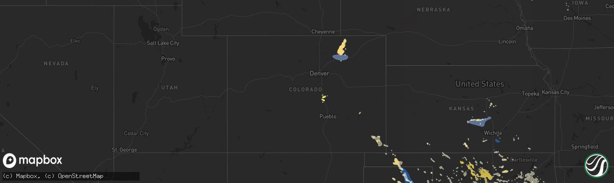
Hail Map in Colorado on June 14, 2025
The weather event in Colorado on June 14, 2025 includes Wind, Hail, and Tornado maps. 22 states and 569 cities were impacted and suffered possible damage. The total estimated number of properties impacted is 31,551.
Want more than just the map?
Turn this storm into a full workflow.
- Owner + property data so you know who to knock
- OnDemand branded weather history reports to win the "did we even have hail?" argument
- RoofTrace estimate so reps stop guessing numbers at the door
Bought this map? Upgrade within 7 days and we'll credit the $230. (10-15 min setup call)
Wind
Hail
Tornado
31,551
Estimated number of impacted properties by a 1.00" hail or larger337
Estimated number of impacted properties by a 1.75" hail or larger0
Estimated number of impacted properties by a 2.50" hail or largerStorm reports in Colorado
Colorado
| Date | Description |
|---|---|
| 06/14/20256:41 PM CDT | Report from mping: quarter |
| 06/14/20256:39 PM CDT | Report from mping: half dollar |
| 06/14/20256:38 PM CDT | Report from mping: quarter |
| 06/14/20256:37 PM CDT | A local report indicates 1.00 inch wind near 6 SSE Air Force Academy |
| 06/14/20256:37 PM CDT | Report from mping: quarter |
| 06/14/20256:35 PM CDT | Report from mping: quarter |
| 06/14/20256:33 PM CDT | Report from mping: quarter |
| 06/14/20256:28 PM CDT | Report from mping: quarter |
| 06/14/20256:26 PM CDT | Report from mping: quarter |
| 06/14/20256:26 PM CDT | A local report indicates 1.00 inch wind near 5 NE Manitou Springs |
| 06/14/20256:24 PM CDT | Report from mping: quarter |
| 06/14/20256:22 PM CDT | Report from mping: half dollar |
| 06/14/202512:12 AM CDT | Ambient weather site struckmeyer reported the gust. (g |
| 06/14/202512:12 AM CDT | Ambient weather site struckmeyer reported the gust. |
| 06/13/20258:55 PM CDT | A local report indicates 66 MPH wind near Fort Morgan Airport |
| 06/13/20258:51 PM CDT | A local report indicates 58 MPH wind near 2 WSW Fort Morgan Airpo |
| 06/13/20258:40 PM CDT | A local report indicates 73 MPH wind near 8 WNW Hoyt Beet Dump |
| 06/13/20258:27 PM CDT | Mesonet station co222 dearfield. |
| 06/13/20257:42 PM CDT | Hailed ranged in size from peas to golfballs. |
| 06/13/20257:16 PM CDT | Report from mping: quarter |
| 06/13/20257:15 PM CDT | A local report indicates 1.00 inch wind near 1 WNW Colorado Springs |
| 06/13/20257:01 PM CDT | A local report indicates 1.00 inch wind near Manitou Springs |
| 06/13/20257:00 PM CDT | A local report indicates 1.00 inch wind near 1 SE Manitou Springs |
| 06/13/20257:00 PM CDT | A local report indicates 1.25 inch wind near 5 NW Peterson AFB |
All States Impacted by Hail Map on June 14, 2025
Cities Impacted by Hail Map on June 14, 2025
- Nashville, KS
- Medicine Lodge, KS
- Sylvia, KS
- Hutchinson, KS
- Chester, OK
- Sand Springs, OK
- Sterling, KS
- Nickerson, KS
- Tulsa, OK
- Sharon, KS
- Sperry, OK
- Hazelton, KS
- Buhler, KS
- Owasso, OK
- Partridge, KS
- South Hutchinson, KS
- Plevna, KS
- Abbyville, KS
- Haven, KS
- Burrton, KS
- Grenola, KS
- Okarche, OK
- El Reno, OK
- Claremore, OK
- Calumet, OK
- Inman, KS
- Catoosa, OK
- Moundridge, KS
- New Cambria, KS
- Mcpherson, KS
- Rose Hill, KS
- Brinkley, AR
- Clarendon, AR
- Milton, KS
- Conway Springs, KS
- Howard, KS
- Gypsum, KS
- Douglass, KS
- Salina, KS
- Chelsea, OK
- Inola, OK
- Broken Arrow, OK
- Chouteau, OK
- Goddard, KS
- Piedmont, OK
- Yukon, OK
- Coweta, OK
- Mulvane, KS
- Udall, KS
- Pryor, OK
- South Haven, KS
- Belle Plaine, KS
- Butte, NE
- Oklahoma City, OK
- Hulbert, OK
- Hope, KS
- Tampa, KS
- Freeport, TX
- Tahlequah, OK
- Bristow, OK
- Locust Grove, OK
- Wagoner, OK
- El Campo, TX
- Castle, OK
- Mounds, OK
- Beggs, OK
- Okmulgee, OK
- Okemah, OK
- Bixby, OK
- Glenpool, OK
- Independence, KS
- Lake Charles, LA
- Paden, OK
- Kellyville, OK
- Wiggins, MS
- Porter, OK
- Seminole, OK
- Earlsboro, OK
- Baton Rouge, LA
- Haskell, OK
- Pitkin, LA
- Greenwell Springs, LA
- Denham Springs, LA
- Redbird, OK
- Vardaman, MS
- Wewoka, OK
- Maud, OK
- Konawa, OK
- Tecumseh, OK
- Wetumka, OK
- North Wilkesboro, NC
- Edna, TX
- Holden, LA
- Roaring River, NC
- Leesville, LA
- Ronda, NC
- Holdenville, OK
- Amite, LA
- Lena, LA
- Leakesville, MS
- Boyce, LA
- Greensburg, LA
- Atwood, OK
- Calvin, OK
- Jonesville, NC
- Hamptonville, NC
- Ada, OK
- Liberty, MS
- Tylertown, MS
- Pine Grove, LA
- Red Oak, OK
- Walker, LA
- Cuero, TX
- Jena, LA
- Poteau, OK
- Wister, OK
- Shady Point, OK
- Brookhaven, MS
- Marthaville, LA
- Yorktown, TX
- Nordheim, TX
- Pineville, LA
- Moravian Falls, NC
- Wilkesboro, NC
- Pleasant Hill, LA
- Bogue Chitto, MS
- Mansfield, LA
- Heavener, OK
- Silver Creek, MS
- Gainestown, AL
- Waldron, AR
- Prentiss, MS
- Yulee, FL
- Howe, OK
- Elgin, TX
- Thrall, TX
- Georgetown, SC
- Nesmith, SC
- Charles City, IA
- Coupland, TX
- Taylorsville, MS
- Purvis, MS
- Sumrall, MS
- Booneville, AR
- Bay Springs, MS
- Natchez, MS
- Gretna, VA
- Java, VA
- Winnsboro, LA
- Hattiesburg, MS
- Newellton, LA
- Mount Ida, AR
- Mena, AR
- Statesboro, GA
- Pachuta, MS
- Rose Hill, MS
- Brooklet, GA
- Monroe, GA
- Louin, MS
- Stockdale, TX
- Catherine, AL
- Cabot, AR
- Floresville, TX
- Utica, MS
- Princeton, LA
- Lonoke, AR
- Mountain Pine, AR
- Alberta, AL
- Safford, AL
- Sutherland Springs, TX
- Poth, TX
- Edwards, MS
- Mebane, NC
- Yanceyville, NC
- Ramer, AL
- Falls City, TX
- Camden, AL
- Big Timber, MT
- Pine Apple, AL
- Montgomery, AL
- Leasburg, NC
- Laurel, NE
- Lenoir, NC
- Minter, AL
- Bolton, MS
- Westwego, LA
- Canton, GA
- Thermopolis, WY
- Caledonia, MS
- Meeteetse, WY
- Ball Ground, GA
- Evergreen, AL
- Steens, MS
- Hamilton, MS
- Columbus, MS
- Taylorsville, NC
- Pleasanton, TX
- Woodstock, AL
- Remsen, IA
- West Blocton, AL
- Roswell, NM
- Waskom, TX
- De Berry, TX
- Saint George, GA
- Kingsley, IA
- Le Mars, IA
- Hinton, IA
- Lexington, MS
- Hartington, NE
- Camden, MS
- Midway, GA
- Fleming, GA
- Saint Marys, WV
- Healdton, OK
- Wilson, OK
- Thomas, OK
- Buffalo, MT
- Aplington, IA
- Millport, AL
- Springer, OK
- Ardmore, OK
- Watonga, OK
- Usaf Academy, CO
- Melville, MT
- Ireton, IA
- Colorado Springs, CO
- Elk Point, SD
- Burbank, SD
- Merrill, IA
- Marietta, TX
- Tichnor, AR
- Ryegate, MT
- Lewistown, MT
- Manson, IA
- Geary, OK
- Littleton, NC
- Rockwell City, IA
- Beresford, SD
- Maurice, IA
- Akron, IA
- Hawarden, IA
- Wausa, NE
- Little Plymouth, VA
- Mattaponi, VA
- Osmond, NE
- Hollister, NC
- Manitou Springs, CO
- Aurelia, IA
- Plainview, NE
- Alcester, SD
- New Raymer, CO
- Lake City, IA
- Douglas, WY
- Glenrock, WY
- Orange City, IA
- Hobson, MT
- Marcus, IA
- Grover, CO
- Peyton, CO
- Alton, IA
- Briggsdale, CO
- Hydro, OK
- Gillette, WY
- Lusk, WY
- Forest Grove, MT
- Roundup, MT
- Moccasin, MT
- Clayton, NM
- Cherokee, IA
- Weldona, CO
- Orchard, CO
- Colony, OK
- Clinton, OK
- Denton, MT
- Kaycee, WY
- Hinton, OK
- Humboldt, IA
- Badger, IA
- Fort Dodge, IA
- Powell, WY
- Newcastle, NE
- Butler, OK
- Odebolt, IA
- Canute, OK
- Foss, OK
- Enid, OK
- Greenville, IA
- Royal, IA
- Pierson, IA
- Hilger, MT
- Buffalo, WY
- Ogden, IA
- Everly, IA
- Wall Lake, IA
- Vincent, IA
- Winifred, MT
- Spencer, IA
- Wiggins, CO
- Perry, OK
- Fort Morgan, CO
- Mulhall, OK
- Orlando, OK
- Webster City, IA
- Cordell, OK
- Fairmont, OK
- Marshall, OK
- Douglas, OK
- Covington, OK
- Washta, IA
- Correctionville, IA
- Lake View, IA
- Woolstock, IA
- Eagle Grove, IA
- Locust Grove, VA
- Dill City, OK
- White Sulphur Springs, MT
- Stanhope, IA
- Kamrar, IA
- Braman, OK
- Edgemont, SD
- Broadus, MT
- Recluse, WY
- Roggen, CO
- Kersey, CO
- Log Lane Village, CO
- Bloomfield, NE
- Battle Creek, IA
- Lucien, OK
- Stillwater, OK
- Jewell, IA
- Geuda Springs, KS
- Newkirk, OK
- Pawnee, OK
- Morrison, OK
- Thor, IA
- Garber, OK
- Story City, IA
- Ellsworth, IA
- Danbury, IA
- Crofton, NE
- Arkansas City, KS
- Radcliffe, IA
- Ponca City, OK
- Lloyd, MT
- Glencoe, OK
- Charter Oak, IA
- Mapleton, IA
- Crescent, OK
- Kaw City, OK
- Red Rock, OK
- Ralston, OK
- Moore, MT
- Buffalo Gap, SD
- Woodward, IA
- Burbank, OK
- Hominy, OK
- Shidler, OK
- Perry, IA
- Woodford, VA
- Chadron, NE
- Bouton, IA
- Hays, MT
- Fairfax, OK
- Pawhuska, OK
- Whitney, NE
- Carrier, OK
- Martinsdale, MT
- Two Dot, MT
- Billings, OK
- Perkins, OK
- Coyle, OK
- Cushing, OK
- Ripley, OK
- Guthrie, OK
- Hennessey, OK
- Wellston, OK
- Edmond, OK
- Meridian, OK
- Tryon, OK
- Carney, OK
- Newell, SD
- Stanford, MT
- Drumright, OK
- Malta, MT
- Wounded Knee, SD
- Manderson, SD
- Mud Butte, SD
- Jones, OK
- Sapulpa, OK
- Mannford, OK
- Skiatook, OK
- Choctaw, OK
- Arcadia, OK
- Stroud, OK
- Agra, OK
- Luther, OK
- Bethany, OK
- Batesland, SD
- Martin, SD
- Ekalaka, MT
- Hammond, MT
- Porcupine, SD
- Kremlin, OK
- Allen, SD
- Pond Creek, OK
- Reva, SD
- Buffalo, SD
- Dacoma, OK
- Alva, OK
- Camp Crook, SD
- Waynoka, OK
- Two Buttes, CO
- Spencer, OK
- Walsh, CO
- Harrah, OK
- Winnett, MT
- Tuthill, SD
- Faith, SD
- Brusett, MT
- Waukomis, OK
- Enning, SD
- Shawnee, OK
- Mcloud, OK
- Cherokee, OK
- Carmen, OK
- White Owl, SD
- Meadow, SD
- Wilmont, MN
- Bison, OK
- Helena, OK
- Marland, OK
- Fulda, MN
- Reading, MN
- Elkhart, KS
- Aline, OK
- Parmelee, SD
- Saint Francis, SD
- Meno, OK
- Ringwood, OK
- Valentine, NE
- Lamont, OK
- Lahoma, OK
- Cleo Springs, OK
- Circle, MT
- Jordan, MT
- Drummond, OK
- Dupree, SD
- Fort Peck, MT
- Worthington, MN
- Rolla, KS
- Ames, OK
- Geyser, MT
- Burlington, OK
- Jet, OK
- McIntosh, SD
- Goltry, OK
- Nash, OK
- Guymon, OK
- Isabella, OK
- Goodwell, OK
- Thedford, NE
- Wolf Point, MT
- Round Lake, MN
- Brewster, MN
- Haswell, CO
- McLaughlin, SD
- Johnstown, NE
- Keldron, SD
- Springview, NE
- Gruver, TX
- Amorita, OK
- Spearman, TX
- Timber Lake, SD
- Coffee Creek, MT
- Vida, MT
- Glencross, SD
- Trail City, SD
- Miami, TX
- Perryton, TX
- Stinnett, TX
- Richey, MT
- Sioux Rapids, IA
- Kingfisher, OK
- Wakpala, SD
- Bloomfield, MT
- Omega, OK
- Sunray, TX
- Linn Grove, IA
- Pampa, TX
- Springfield, CO
- Morse, TX
- Booker, TX
- Keyes, OK
- Okeene, OK
- Alta, IA
- Follett, TX
- Fowler, KS
- Granville, IA
- Ninnekah, OK
- Glenham, SD
- Mound City, SD
- Pomeroy, IA
- Canadian, TX
- Chickasha, OK
- Laverne, OK
- Loyal, OK
- Mountain View, OK
- Fairview, OK
- Vici, OK
- Buffalo, OK
- Mobeetie, TX
- Wheeler, TX
- Savage, MT
- Vilas, CO
- Anadarko, OK
- Arnett, OK
- Freedom, OK
- Jolley, IA
- Marlow, OK
- Fargo, OK
- Roy, MT
- Reydon, OK
- Oakwood, OK
- Briscoe, TX
- Gotebo, OK
- Greenfield, OK
- Lawton, OK
- Seiling, OK
- Sharon, OK
- Terry, MT
- Larrabee, IA
- Brockway, MT
- Shamrock, TX
- Paullina, IA
- Walters, OK
- Sweetwater, OK
- Lytton, IA
- Erick, OK
- Bowdle, SD
- Weatherford, OK
- Wellington, TX
- Cohagen, MT
- Utica, SD
- Menno, SD
- Texola, OK
- Woodward, OK
- Fort Supply, OK
- Leedey, OK
- Hosmer, SD
- Sayre, OK
- Custer City, OK
- Saint Helena, NE
- Fordyce, NE
- Yankton, SD
- Tabor, SD
- Mooreland, OK
- Camargo, OK
- Taloga, OK
- Wynot, NE
- Carter, OK
- Sentinel, OK
- Roosevelt, OK
- Willow, OK
- Mclean, TX
- Granite, OK
- Lone Wolf, OK
- Gayville, SD
- Longdale, OK
- Duncan, OK


