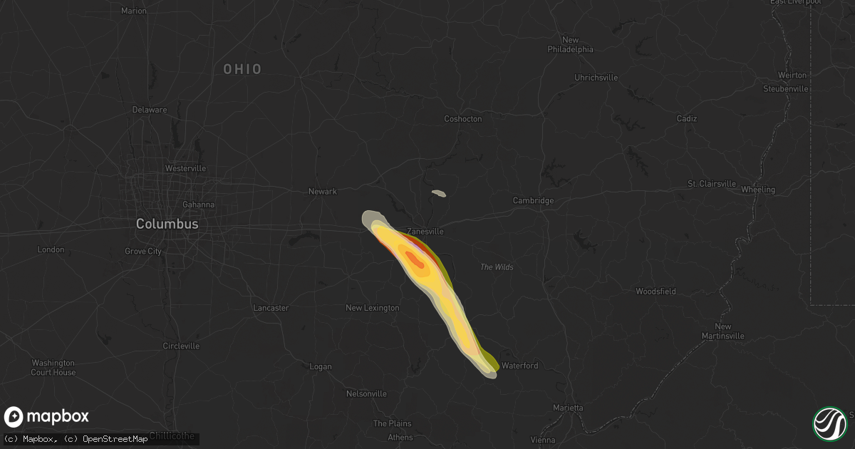
Hail Map in Zanesville, OH on June 14, 2024
Get this storm
June 14 map
$229
one time, instant access
Download today. No call, no setup
Keep the $229
Bought the map and want the full workflow? Apply the entire $229 to a subscription within 7 days. None of it is wasted.
Every map, not just this one
This buys you this map. Subscription and you get every map we run, in the markets you choose from a few cities to whole states to nationwide. Plus real-time alerts the moment a storm fires.
Contact data
Name, contact info, occupancy, even credit band for addresses in the footprint. You go from where it hit to who to call.
Become the source they trust
Unlimited branding weather history reports on demand. You already have the documented answer ready for the property owner, and you are the one who showed up with it.
Property data and RoofTrace estimates
Pull up any address you have got, its value and the exact code rules for that jurisdiction, straight from One Click Code. Then RoofTrace estimates the squares, pitch, and roof value, priced the way you price.
Storm reports in Zanesville, OH
Zanesville, OH
| Date | Description |
|---|---|
| 06/14/20244:25 PM CDT | A local report indicates 1.00 inch wind near 1 ESE Avondale |
| 06/14/20244:24 PM CDT | A local report indicates 2.00 inch wind near South Zanesville |
| 06/14/20244:24 PM CDT | Corrected location based on additional information from observer |
| 06/14/20244:23 PM CDT | A local report indicates 1.00 inch wind near White Cottage |
| 06/14/20244:23 PM CDT | Report of tree down along huggins road. Time estimated based on radar. |
| 06/14/20244:22 PM CDT | Em reporting damage to multiple homes southwest of zanesville and near the maysville middle school. |
| 06/14/20244:22 PM CDT | Report of power poles broken in the area. Time estimated based on radar. |
| 06/14/20244:22 PM CDT | *** 1 inj *** tree fell on camper at up the creek campground. |
| 06/14/20244:21 PM CDT | Public reported between nickel to quarter size hail just off state route 22. Time estimated based on radar. |
| 06/14/20244:17 PM CDT | Report of trees uprooted or snapped in area. Time estimated based on radar. |
All States Impacted by Hail Map on June 14, 2024
All Cities Impacted by Hail Map on June 14, 2024
- Goodland, KS
- Syracuse, KS
- Johnson, KS
- Edgemont, SD
- Oelrichs, SD
- Hot Springs, SD
- Oral, SD
- Manter, KS
- Corsica, PA
- Brookville, PA
- Ovid, CO
- Chappell, NE
- Revere, MA
- Malden, MA
- Everett, MA
- Medford, MA
- Chelsea, MA
- Winchester, MA
- Saugus, MA
- Melrose, MA
- Bushnell, NE
- Haigler, NE
- Kimball, NE
- Coshocton, OH
- West Lafayette, OH
- Fresno, OH
- Newcomerstown, OH
- Kimbolton, OH
- Farmington, ME
- Norridgewock, ME
- New Sharon, ME
- Oakland, ME
- Aguilar, CO
- Walsenburg, CO
- Fort Fairfield, ME
- Limestone, ME
- Smithfield, ME
- Gurley, NE
- Lima, MT
- Springer, NM
- Conifer, CO
- Littleton, CO
- Winn, ME
- Raton, NM
- Lincoln, ME
- South Hadley, MA
- Amherst, MA
- Granby, MA
- Rocky Ford, CO
- Pueblo, CO
- Belchertown, MA
- Model, CO
- Mosquero, NM
- Sugar City, CO
- Conchas Dam, NM
- Ogallala, NE
- Potter, NE
- Roy, NM
- Gladstone, NM
- Clayton, NM
- Kennett Square, PA
- Dalton, NE
- Trinidad, CO
- Trinchera, CO
- Torrington, WY
- Logan, NM
- Hopewell, OH
- Heath, OH
- Zanesville, OH
- Mount Perry, OH
- Bellingham, MA
- Wrentham, MA
- Franklin, MA
- Ridgeley, WV
- Branson, CO
- Grenora, ND
- Sidney, NE
- Roseville, OH
- White Cottage, OH
- Eckley, CO
- Springfield, WV
- Cumberland, MD
- Fort Ashby, WV
- Zahl, ND
- New Town, ND
- Ramah, CO
- Agate, CO
- Byers, CO
- Deer Trail, CO
- Tucumcari, NM
- San Jon, NM
- Grenville, NM
- Philo, OH
- Blue Rock, OH
- Mcconnelsville, OH
- Arriba, CO
- Nara Visa, NM
- Roseglen, ND
- Green Spring, WV
- Wray, CO
- Lyman, NE
- La Junta, CO
- Fairless Hills, PA
- Fort Morgan, CO
- Alamo, ND
- Crooksville, OH
- Foxboro, MA
- Yuma, CO
- Plainville, MA
- Swink, CO
- Cheraw, CO
- Malta, OH
- Stockholm, NJ
- Levels, WV
- Points, WV
- Paw Paw, WV
- Slanesville, WV
- Broadwater, NE
- Trenton, NJ
- Bordentown, NJ
- Coxs Creek, KY
- Las Animas, CO
- Oldtown, MD
- Stockport, OH
- Ray, ND
- Arlington, CO
- Tioga, ND
- Powers Lake, ND
- Anton, CO
- Otis, CO
- Cope, CO
- Bard, NM
- Kissimmee, FL
- Intercession City, FL
- Davenport, FL
- Harrison, NE
- Akron, CO
- Lindon, CO
- Capon Bridge, WV
- Haxtun, CO
- Lodgepole, NE
- Tappan, NY
- Palisades, NY
- Westwood, NJ
- Norwood, NJ
- Northvale, NJ
- Orangeburg, NY
- Matawan, NJ
- Old Bridge, NJ
- Piermont, NY
- Sparkill, NY
- Harrington Park, NJ
- Park Ridge, NJ
- Pearl River, NY
- Tarrytown, NY
- Montvale, NJ
- Nyack, NY
- Blauvelt, NY
- Cubero, NM
- Haines City, FL
- Waterford, OH
- Alpine, NJ
- Genoa, CO
- Stanley, ND
- Kenmare, ND
- Winter Haven, FL
- White Earth, ND
- Dobbs Ferry, NY
- Hastings On Hudson, NY
- Irvington, NY
- Hasty, CO
- Eads, CO
- Wiley, CO
- McClave, CO
- Lamar, CO
- Haswell, CO
- Florence, NJ
- Mount Holly, NJ
- Burlington, NJ
- Columbus, NJ
- Roebling, NJ
- New Egypt, NJ
- Jackson, NJ
- Mantoloking, NJ
- Brick, NJ
- Chesterfield, NJ
- Wrightstown, NJ
- Allentown, NJ
- Jobstown, NJ
- Cream Ridge, NJ
- Cookstown, NJ
- Lakewood, NJ
- Joint Base Mdl, NJ
- Manchester Township, NJ
- Toms River, NJ
- Ocean Grove, NJ
- Avon By The Sea, NJ
- West Long Branch, NJ
- Howell, NJ
- Sea Girt, NJ
- Oakhurst, NJ
- Colts Neck, NJ
- Asbury Park, NJ
- Allenwood, NJ
- Farmingdale, NJ
- Freehold, NJ
- Deal, NJ
- Millstone Township, NJ
- Allenhurst, NJ
- Englishtown, NJ
- Point Pleasant Beach, NJ
- Long Branch, NJ
- Belmar, NJ
- Bradley Beach, NJ
- Brielle, NJ
- Spring Lake, NJ
- Eatontown, NJ
- Manasquan, NJ
- Neptune, NJ
- Robbinsville, NJ
- Texline, TX
- Dalhart, TX
- Lakehurst, NJ
- Fairfield, CT
- Westport, CT
- Broadview, NM
- Grady, NM
- Woodcliff Lake, NJ
- Hillsdale, NJ
- Melrose, NM
- Holyoke, CO
- Pemberton, NJ
- Clovis, NM
- Walsh, CO
- Southport, CT
- Springfield, CO
- Sheridan Lake, CO
- Holly, CO
- Granada, CO
- Boise City, OK
- Felt, OK
- Red Bank, NJ
- Rumson, NJ
- Oceanport, NJ
- Monmouth Beach, NJ
- Little Silver, NJ
- Fort Monmouth, NJ
- Shrewsbury, NJ
- Fair Haven, NJ
- Lincroft, NJ
- Marlboro, NJ
- Kiowa, CO
- Two Buttes, CO
- Stratford, TX
- Fleming, CO
- Norwalk, CT
- Oshkosh, NE
- Arvada, WY
- Adrian, TX
- Vernon, CO
- Keyes, OK
- Goodwell, OK
- Elkhart, KS
- Texhoma, OK
- Walker, WV
- Stratton, NE
- Elida, NM
- Marienthal, KS
- Scott City, KS
- Sharon Springs, KS
- Windham, ME
- Gray, ME
- Cannon Afb, NM
- Otis, MA
- Tyringham, MA
- Waverly, WV
- Petroleum, WV
- Elizabeth, WV
- Rolla, KS
- Richfield, KS
- Hugoton, KS
- Ulysses, KS
- Oakley, KS
- Benkelman, NE
- Macfarlan, WV
- Portales, NM
- Floyd, NM
- Grinnell, KS
- Broadus, MT
- Farwell, TX
- Hoxie, KS
- Rexford, KS
- Selden, KS
- Lewellen, NE
- Paxton, NE
- Dresden, KS
- Oberlin, KS
- Colby, KS
- Palisade, NE
- Wauneta, NE
- Trenton, NE
- Jennings, KS
- Norcatur, KS
- Hayes Center, NE
- Lenora, KS
- Herndon, KS
- Max, NE
- Culbertson, NE
- Columbus, ND
- McCook, NE
- Texico, NM
- Mcgregor, ND
- Almena, KS
- Norton, KS
- Wildrose, ND
- Morland, KS
- Maywood, NE
- Danbury, NE
- Curtis, NE
- Bartley, NE
- Cambridge, NE
- Phillipsburg, KS
- Logan, KS
- Oxford, NE
- Prairie View, KS
- Long Island, KS
- Alma, NE
- Hendley, NE
- Stamford, NE
- Orleans, NE
- Beaver City, NE
- Naponee, NE
- Republican City, NE
- Bloomington, NE
- Funk, NE
- Wilcox, NE
- Atlanta, NE
- Holdrege, NE
- Taylors Island, MD
- Madison, MD
- Hildreth, NE
- Axtell, NE
- Franklin, NE
- Minden, NE
- Upland, NE
- Glade, KS
- Gothenburg, NE
- Brewster, NE
- Natoma, KS
- Kirwin, KS
- Gaylord, KS
- Kensington, KS
- Russell, KS
- Gorham, KS
- Douglas, ND
- Agra, KS
- Stockton, KS
- Woodston, KS
- Pep, NM
- Paradise, KS
- Cedar, KS
- Arnold, NE
- Stapleton, NE
- Anselmo, NE
- Merna, NE
- Callaway, NE
- Halsey, NE
- Broken Bow, NE
- Ansley, NE
- Comstock, NE
- Westerville, NE
- Dunning, NE
- Buffalo, SD
- Reva, SD
- Claflin, KS
- Bunker Hill, KS
- Ralph, SD
- Holyrood, KS
- Portis, KS
- Downs, KS
- Crook, CO
- Bushton, KS
- Dorrance, KS
- Wilson, KS
- Lorraine, KS
- Esbon, KS
- Lebanon, KS
- Ellsworth, KS
- Sylvan Grove, KS
- Geneseo, KS
- Mankato, KS
- Hunter, KS
- Hettinger, ND
- Beloit, KS
- Barnard, KS
- Lyons, KS
- Lincoln, KS
- Beverly, KS
- Minneapolis, KS
- Tescott, KS
- Salina, KS
- Fairbury, NE
- Western, NE
- Swanton, NE
- Bennington, KS
- Blue Springs, NE
- Beatrice, NE
- Crab Orchard, NE
- Filley, NE
- Lincoln, NE
- Home, KS
- Marysville, KS
- Pawnee City, NE
- Donnybrook, ND
- Steinauer, NE
- Table Rock, NE
- Frankfort, KS
- Killdeer, ND
- Johnson, NE
- Axtell, KS
- Humboldt, NE
- Brock, NE
- Auburn, NE
- Baileyville, KS
- Centralia, KS
- Du Bois, NE
- Seneca, KS
- Bern, KS
- Sabetha, KS
- Oneida, KS
- Goff, KS
- Soldier, KS
- Wetmore, KS
- Circleville, KS
- Lee, ME


