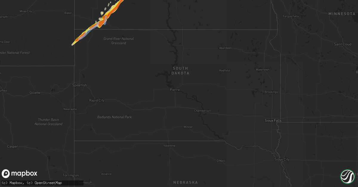
Hail Map in South Dakota on June 14, 2020
Get this storm
June 14 map
$229
one time, instant access
Download today. No call, no setup
Keep the $229
Bought the map and want the full workflow? Apply the entire $229 to a subscription within 7 days. None of it is wasted.
Every map, not just this one
This buys you this map. Subscription and you get every map we run, in the markets you choose from a few cities to whole states to nationwide. Plus real-time alerts the moment a storm fires.
Contact data
Name, contact info, occupancy, even credit band for addresses in the footprint. You go from where it hit to who to call.
Become the source they trust
Unlimited branding weather history reports on demand. You already have the documented answer ready for the property owner, and you are the one who showed up with it.
Property data and RoofTrace estimates
Pull up any address you have got, its value and the exact code rules for that jurisdiction, straight from One Click Code. Then RoofTrace estimates the squares, pitch, and roof value, priced the way you price.
Storm reports in South Dakota
South Dakota
| Date | Description |
|---|---|
| 06/14/20204:54 PM CDT | A local report indicates 1.25 inch wind near 9 NW LUDLOW |
| 06/14/20204:20 PM CDT | Nickel to quarter sized hail |
| 06/14/20204:05 PM CDT | Delayed report. Time estimated from radar. |
| 06/14/20203:55 PM CDT | Delayed report |
| 06/14/20203:55 PM CDT | A local report indicates 1.00 inch wind near 7 NNE CAMP CROOK |
| 06/13/20207:51 PM CDT | A local report indicates 58 MPH wind near 1 NE WINNER |
All States Impacted by Hail Map on June 14, 2020
Cities Impacted by Hail Map on June 14, 2020
- Murphy, NC
- Marietta, GA
- Roswell, GA
- Woodstock, GA
- Morganfield, KY
- Sturgis, KY
- Tioga, ND
- White Earth, ND
- Hampton, GA
- Fruithurst, AL
- Muscadine, AL
- Tallapoosa, GA
- Cedartown, GA
- Piedmont, AL
- Griffin, GA
- Bluff City, TN
- Piney Flats, TN
- Franklin, TN
- College Grove, TN
- Chapel Hill, TN
- New Town, ND
- Stanley, ND
- Watford City, ND
- Sterling, CO
- Wildrose, ND
- Kenmare, ND
- Whitman, NE
- Ringgold, GA
- Rocky Face, GA
- Palermo, ND
- Donnybrook, ND
- Reeder, ND
- New England, ND
- Camp Crook, SD
- Lefor, ND
- Brasstown, NC
- Alamo, ND
- Thompsons Station, TN
- Riverdale, GA
- Jonesboro, GA
- Forest Park, GA
- Mohall, ND
- Tolley, ND
- Ray, ND
- Arnegard, ND
- Sherwood, ND
- Berthold, ND
- Ross, ND
- Antler, ND
- Spring Hill, TN
- Columbia, TN
- Eagleville, TN
- Fairfield, ND
- Belfield, ND
- Rockwood, TN
- Spring City, TN
- Bowman, ND
- Ludlow, SD
- Winder, GA
- Hoschton, GA
- Regent, ND
- Powers Lake, ND
- Hayesville, NC
- Atlanta, GA
- Columbus, ND
- Statham, GA
- Bogart, GA
- Ten Mile, TN
- Grassy Butte, ND
- Hazen, ND
- Beulah, ND
- Dallas, GA
- Ochopee, FL
- Keene, ND
- Mandaree, ND
- Evensville, TN
- Emerson, GA
- Cartersville, GA
- Taylor, ND
- Squire, WV
- Berwind, WV
- Ellijay, GA
- Medora, ND
- Sentinel Butte, ND
- Duck River, TN
- Hampshire, TN
- Williamsport, TN
- Primm Springs, TN
- Eskdale, WV
- Amidon, ND
- Crosby, ND
- Morrow, GA
- Fayetteville, GA
- Bee, VA
- Haysi, VA
- Birchleaf, VA
- Johnson City, TN
- Jonesborough, TN
- Cartwright, ND
- Winston, GA
- Douglasville, GA
- Immokalee, FL
- Waleska, GA
- Fairmount, GA
- Ranger, GA
- Talking Rock, GA
- Jasper, GA
- Manning, ND
- Capitol, MT
- Greeneville, TN
- Scranton, ND
- Mott, ND
- Ekalaka, MT
- Buffalo, SD
- Richardton, ND
- Portal, ND
- Canton, GA
- Zap, ND
- Dayton, TN
- Hebron, ND
- Beach, ND
- Killdeer, ND
- Shady Valley, TN
- White, GA
- Blackwater, VA
- Monroe, GA
- Lizemores, WV
- Marshall, NC
- Acworth, GA
- Knoxville, TN
- Whitesville, WV
- Sylvester, WV
- Chatsworth, GA
- Alzada, MT
- Denham Springs, LA
- Coeburn, VA
- Pikeville, TN
- Centerville, TN
- Lansford, ND
- Carpio, ND
- Cave Spring, GA
- Lindale, GA
- Dacula, GA
- Bethlehem, GA
- Hammond, LA
- Clyde, NC
- Foxworth, MS
- Lewisburg, TN
- Watauga, TN
- Blairsville, GA
- Shawneetown, IL
- Heflin, AL
- Duson, LA
- Gueydan, LA
- Winchester, KY
- Saint Francisville, LA
- Jeffersonville, KY
- Dawsonville, GA
- Iliff, CO
- Lawrenceville, GA
- Goodland, KS
- Sharon Springs, KS
- Edson, KS
- Arapahoe, CO
- Weskan, KS
- Wallace, KS
- Arrington, TN


