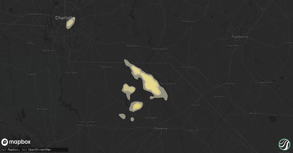
Hail Map in Cheraw, SC on June 14, 2016
Get this storm
June 14 map
$229
one time, instant access
Download today. No call, no setup
Keep the $229
Bought the map and want the full workflow? Apply the entire $229 to a subscription within 7 days. None of it is wasted.
Every map, not just this one
This buys you this map. Subscription and you get every map we run, in the markets you choose from a few cities to whole states to nationwide. Plus real-time alerts the moment a storm fires.
Contact data
Name, contact info, occupancy, even credit band for addresses in the footprint. You go from where it hit to who to call.
Become the source they trust
Unlimited branding weather history reports on demand. You already have the documented answer ready for the property owner, and you are the one who showed up with it.
Property data and RoofTrace estimates
Pull up any address you have got, its value and the exact code rules for that jurisdiction, straight from One Click Code. Then RoofTrace estimates the squares, pitch, and roof value, priced the way you price.
Storm reports in Cheraw, SC
Cheraw, SC
| Date | Description |
|---|---|
| 06/14/20164:59 PM CDT | Media reported via social media trees and powerlines downed along highway 52. Large limbs down in yards and on powerlines in the community of cash. . |
| 06/14/20164:59 PM CDT | County highway department reported 6 trees uprooted along highway 52 between cheraw and society hill. . |
| 06/14/20164:24 PM CDT | Downed trees and blown transformer on market street. |
| 06/14/20164:20 PM CDT | Downed power lines legrand and bepot streets. |
| 06/14/20164:07 PM CDT | Trees down. 2 vehicle windshields knocked out by flying debris and metal siding. Via social media. |
All States Impacted by Hail Map on June 14, 2016
All Cities Impacted by Hail Map on June 14, 2016
- Spencer, IA
- Milford, IA
- Everly, IA
- Loring, MT
- Malta, MT
- Fort Peck, MT
- Cheraw, SC
- Chesterfield, SC
- Winthrop, MN
- Gadsden, SC
- Dedham, IA
- Coon Rapids, IA
- Duncan, OK
- Nashville, TN
- Shullsburg, WI
- Cuba City, WI
- Benton, WI
- Ainsworth, NE
- Johnstown, NE
- Hartsville, SC
- Adel, IA
- Dallas Center, IA
- Crofton, KY
- White Plains, KY
- Dunlap, IA
- Pembroke, NC
- Campbellsville, KY
- Mammoth Cave, KY
- Fort Stockton, TX
- Chinook, MT
- McBee, SC
- Savannah, GA
- Patrick, SC
- Spirit Lake, IA
- Brewster, MN
- Reading, MN
- Worthington, MN
- Round Lake, MN
- Wilmont, MN
- Lakefield, MN
- Fulda, MN
- Welcome, MN
- Sherburn, MN
- Perry, IA
- Dawson, IA
- Fayetteville, GA
- Sweetwater, TN
- Scranton, IA
- Baker, MT
- Campbellsburg, IN
- Paoli, IN
- Orleans, IN
- Wallace, NC
- Willard, NC
- Ratliff City, OK
- Wood Lake, NE
- Amelia, NE
- Chambers, NE
- Bartlett, NE
- Burwell, NE
- Ewing, NE
- Forest Park, GA
- Alden, MN
- Kincaid, KS
- Jackson, MN
- Paducah, TX
- Butler, MO
- Emmetsburg, IA
- Silver Lake, KS
- Topeka, KS
- Glidden, IA
- New Hampton, IA
- Riceville, IA
- Elma, IA
- Nashua, IA
- Orchard, IA
- Ionia, IA
- Charles City, IA
- Alta Vista, IA
- Walland, TN
- Maryville, TN
- Miles, IA
- Preston, IA
- Culbertson, MT
- Hoyt, KS
- Townsend, GA
- Stuart, NE
- Bassett, NE
- Thomson, GA
- Washington, GA
- Norwood, GA
- Lincolnton, GA
- Barnesville, GA
- Culloden, GA
- Cross Timbers, MO
- Richlands, NC
- Saint Marys, KS
- Jonesboro, GA
- Riverdale, GA
- Macks Creek, MO
- Tunas, MO
- Early, IA
- Sac City, IA
- Lake View, IA
- Darlington, SC
- Castana, IA
- Onawa, IA
- Woodbine, IA
- Arion, IA
- Dow City, IA
- Savage, MT
- Jefferson, SC
- Lloyd, MT
- Montgomery, MN
- Toulon, IL
- Long Pine, NE
- Mankato, MN
- Good Thunder, MN
- Locust Grove, GA
- Mcdonough, GA
- Canon, GA
- Panora, IA
- Buffalo, SD
- Jesup, GA
- Reynolds, GA
- Cedar Bluffs, NE
- Chinquapin, NC
- Jacksonville, NC
- Beulaville, NC
- Wamego, KS
- Rossville, KS
- Maple Hill, KS
- Paxico, KS
- Belvue, KS
- Delia, KS
- Lake Park, IA
- Bennettsville, SC
- Society Hill, SC
- Paola, KS
- McGregor, IA
- Farmersburg, IA
- Eastanollee, GA
- Toccoa, GA
- Martin, GA
- Hays, MT
- Hephzibah, GA
- Ray, ND
- Matador, TX
- Preston, MO
- Mountain Lake, MN
- Bradgate, IA
- Boston, KY
- Shepherdsville, KY
- Lebanon Junction, KY
- Elizabethtown, KY
- Brooks, KY
- Louisville, KY
- New Haven, KY
- West Point, KY
- Hazel Green, WI
- Valentine, NE
- Ninnekah, OK
- Rush Springs, OK
- Fredericksburg, IA
- Lowry City, MO
- Waterville, MN
- Kilkenny, MN
- Garden City, MN
- Lake Crystal, MN
- Covington, GA
- Camp Crook, SD
- Vernon Center, MN
- Madelia, MN
- Lewisville, MN
- Amboy, MN
- Swainsboro, GA
- Dorchester, SC
- Stockbridge, GA
- Marlow, OK
- Fletcher, OK
- Charlotte, NC
- Richmond Hill, GA
- Delavan, MN
- Blue Earth, MN
- Bricelyn, MN
- Easton, MN
- Wells, MN
- Elmore, MN
- Atkinson, IL
- Cambridge, IL
- Gaston, SC
- West Columbia, SC
- Hopkins, SC
- Fairmont, MN
- Alpha, MN
- Stanton, NE
- Norfolk, NE
- Walnut, IL
- Harmon, IL
- Pamplico, SC
- Florence, SC
- Geneseo, IL
- Frederick, OK
- Crawfordville, GA
- Spartanburg, SC
- Kissimmee, FL
- Orlando, FL
- Audubon, IA
- Plainfield, IA
- Parker, KS
- Lugoff, SC
- Eastover, SC
- Ottawa, KS
- Wellsville, KS
- Mount Carroll, IL
- Savanna, IL
- Effingham, SC
- Royal, IA
- West Bend, IA
- Rolfe, IA
- Aldrich, MO
- Forest City, NC
- Council, NC
- Clarkton, NC
- Kelly, NC
- Riegelwood, NC
- Lake Waccamaw, NC
- Bryant, AL
- Appleton City, MO
- Dalton, GA
- Carnegie, OK
- Terre Haute, IN
- Brazil, IN
- Saint Cloud, FL
- Dixon, NE
- Trimont, MN
- Monona, IA
- Bagley, IA
- Monticello, KY
- Harleyville, SC
- Sumner, IA
- Galena, IL
- Scales Mound, IL
- Cleveland, GA
- Adrian, MN
- Rushmore, MN
- Frost, MN
- Deepwater, MO
- Brockton, MT
- Luana, IA
- Saint Olaf, IA
- Garnavillo, IA
- Bolton, NC
- Truman, MN
- Chadbourn, NC
- Clarendon, NC
- Tabor City, NC
- Old Fort, TN
- Minnesota Lake, MN
- Marietta, GA
- Yale, IA
- Elk Point, SD
- Jefferson, IA
- Cresco, IA
- Springview, NE
- Lawton, OK
- Cache, OK
- Meriden, KS
- Mayetta, KS
- Tampico, IL
- Deer Grove, IL
- Tecumseh, KS
- Brunswick, GA
- Saint Anthony, IN
- Huntingburg, IN
- Ferdinand, IN
- Tipton, OK
- Snyder, OK
- Morgantown, KY
- Morristown, MN
- Pecatonica, IL
- Davis, IL
- Ridott, IL
- Rock City, IL
- Ellenwood, GA
- Newcastle, NE
- Crestview, FL
- Eglin Afb, FL
- Defuniak Springs, FL
- Stockton, MO
- Redfield, IA
- Linden, IA
- Prophetstown, IL
- Bristow, IA
- Maquoketa, IA
- Westminster, SC
- Foster, MO
- Monroe, NC
- Conyers, GA
- Apache, OK
- Greene, IA
- Delmar, IA
- Mitchellville, IA
- Altoona, IA
- Minburn, IA
- Concord, GA
- Williamson, GA
- Senoia, GA
- Lebanon, KY
- Bradfordsville, KY
- Saint Meinrad, IN
- Evanston, IN
- Hawarden, IA
- Bowling Green, KY
- Elberta, AL
- Lillian, AL
- Beaufort, NC
- Harkers Island, NC
- Osceola, MO
- Buffalo Center, IA
- Lakota, IA
- Columbia, SC
- Richey, MT
- Cascade, IA
- Worthington, IA
- Aredale, IA
- Dumont, IA
- Lancaster, SC
- Waverly, IA
- Osage, IA
- Bishopville, SC
- Fort Stewart, GA
- Hinesville, GA
- Morehead City, NC
- Punta Gorda, FL
- Chesnee, SC
- Whiteville, NC
- Bloomfield, MT
- Westside, IA
- Hortense, GA
- Loudon, TN
- Philadelphia, TN
- Springfield, MN
- Hampton, GA
- Arbela, MO
- Humansville, MO
- New Town, ND
- Winside, NE
- Carroll, NE
- Cross, SC
- Eutawville, SC
- Summerville, SC
- Mullins, SC
- Fork, SC
- Elizabeth, IL
- Sabula, IA
- Urbandale, IA
- Clive, IA
- Waukee, IA
- Rockford, IA
- Atlantic Beach, NC
- Childress, TX
- Atchison, KS
- Rushville, MO
- Bloomingdale, GA
- Pooler, GA
- Elgin, OK
- Hanover, IL
- Green Sea, SC
- Guthrie Center, IA
- Memphis, MO
- Schaller, IA
- Elgin, NE
- Medicine Lake, MT
- Casey, IA
- Ruby, SC
- Cerro Gordo, NC
- Timmonsville, SC
- Kiron, IA
- Deloit, IA
- Vail, IA
- Lamar, SC
- Emmons, MN
- Northwood, IA
- Glenville, MN
- Clermont, IA
- Elgin, IA
- Postville, IA
- Sevierville, TN
- Turkey, NC
- Magnolia, NC
- Clinton, NC
- Rockville, MO
- Volga, IA
- Wadena, IA
- Waynesboro, GA
- Quincy, IL
- Clayton, IL
- Camp Point, IL
- Runnells, IA
- Prairie City, IA
- Wadesboro, NC
- Morven, NC
- Blenheim, SC
- Saint James, MN
- Tignall, GA
- Sheldon, IA
- Ashton, IA
- Pocahontas, IA
- Gilmore City, IA
- Soldier, IA
- Stuart, IA
- Menlo, IA
- Allons, TN
- Granada, MN
- Seymour, TN
- Liberty, IL
- Payson, IL
- Lindsay, OK
- Oregon, IL
- Dixon, IL
- White Oak, NC
- Johnston, IA
- Lawler, IA
- Gibbon, MN
- Lafayette, MN
- Conley, GA
- Morrow, GA
- Atlanta, GA
- Pleasant Hill, IA
- Hoskins, NE
- Hume, IL
- Brocton, IL
- Marble Rock, IA
- Floyd, IA
- Twin City, GA
- Mulberry, FL
- Janesville, MN
- Fair Bluff, NC
- Mooresboro, NC
- Rutherfordton, NC
- Fort Sill, OK
- Lumberton, NC
- Hamlin, IA
- Bingham Lake, MN
- Cayce, SC
- Elizabethtown, NC
- Fayetteville, NC
- Linn Grove, IA
- Ivanhoe, NC
- Nichols, SC
- Hodgenville, KY
- Seymour, TX
- Rockford, TN
- Ekalaka, MT
- Newell, SD
- Belle Fourche, SD


