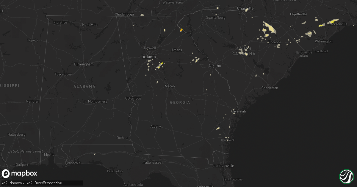
Hail Map in Georgia on June 14, 2016
Get this storm
June 14 map
$229
one time, instant access
Download today. No call, no setup
Keep the $229
Bought the map and want the full workflow? Apply the entire $229 to a subscription within 7 days. None of it is wasted.
Every map, not just this one
This buys you this map. Subscription and you get every map we run, in the markets you choose from a few cities to whole states to nationwide. Plus real-time alerts the moment a storm fires.
Contact data
Name, contact info, occupancy, even credit band for addresses in the footprint. You go from where it hit to who to call.
Become the source they trust
Unlimited branding weather history reports on demand. You already have the documented answer ready for the property owner, and you are the one who showed up with it.
Property data and RoofTrace estimates
Pull up any address you have got, its value and the exact code rules for that jurisdiction, straight from One Click Code. Then RoofTrace estimates the squares, pitch, and roof value, priced the way you price.
Storm reports in Georgia
Georgia
| Date | Description |
|---|---|
| 06/14/20164:58 PM CDT | Report of line down / power outage. |
| 06/14/20164:25 PM CDT | 911 call center received report of 3 trees down...one at the board of education...one near the mountain lakes resort around alternate 75...and one at tractor supply. Al |
| 06/14/20163:42 PM CDT | Many power poles reported blown down on shorewood circle. |
| 06/14/20163:42 PM CDT | Spotter relayed report of golfball size hail on shorewood circle. |
| 06/14/20162:35 PM CDT | Public reported large section of heavy wooden fence and trees down at the savannah mall. Winds were estimated at 60 mph. |
| 06/14/20162:12 PM CDT | Report of a large tree down in residential backyard near cedar point rd and ga hwy 99. Damage sustained to boat and storage shelter |
| 06/14/20162:10 PM CDT | Quarter size hail near heaton rd |
| 06/14/20162:10 PM CDT | In addition to quarter size hail... 2 trees blown down in backyard along heaton rd |
| 06/14/20162:01 PM CDT | Warning point reported tree down at the intersection of cypress street and cregor street |
| 06/14/20162:00 PM CDT | Bloomingdale fire dept reports approx 15 trees down and 10 homes damaged in an area bound by hwy 80...cypress st...chestnut st...and 1 block south of cregor st. Time es |
| 06/14/20162:00 PM CDT | Glynn county 911/dispatch reports multiple powerlines downed by strong wind gusts throughout the county. |
| 06/14/20162:00 PM CDT | Warning point reported power lines down on the 300 block of east main street. |
| 06/14/20161:45 PM CDT | Trained spotter reported large pine tree down on 500 block of prince road. |
| 06/14/20161:35 PM CDT | Quarter size hail reported near ola |
| 06/14/20161:20 PM CDT | Large tree down at broadhurst rd and hwy 301 |
| 06/14/20161:16 PM CDT | Large trees down on gardi road |
| 06/14/20161:15 PM CDT | Numerous trees down in south part of dalton. One on structure on liberty dr |
| 06/14/20161:15 PM CDT | Numerous trees down in south part of dalton. One on structure on liberty dr |
| 06/13/201610:12 PM CDT | Photos from screven county fire dept show multiple trees and large tree limbs down at a residence on sc hwy 24 between friendship rd and rifle rd |
All States Impacted by Hail Map on June 14, 2016
Cities Impacted by Hail Map on June 14, 2016
- Spencer, IA
- Milford, IA
- Everly, IA
- Loring, MT
- Malta, MT
- Fort Peck, MT
- Cheraw, SC
- Chesterfield, SC
- Winthrop, MN
- Gadsden, SC
- Dedham, IA
- Coon Rapids, IA
- Duncan, OK
- Nashville, TN
- Shullsburg, WI
- Cuba City, WI
- Benton, WI
- Ainsworth, NE
- Johnstown, NE
- Hartsville, SC
- Adel, IA
- Dallas Center, IA
- Crofton, KY
- White Plains, KY
- Dunlap, IA
- Pembroke, NC
- Campbellsville, KY
- Mammoth Cave, KY
- Fort Stockton, TX
- Chinook, MT
- McBee, SC
- Savannah, GA
- Patrick, SC
- Spirit Lake, IA
- Brewster, MN
- Reading, MN
- Worthington, MN
- Round Lake, MN
- Wilmont, MN
- Lakefield, MN
- Fulda, MN
- Welcome, MN
- Sherburn, MN
- Perry, IA
- Dawson, IA
- Fayetteville, GA
- Sweetwater, TN
- Scranton, IA
- Baker, MT
- Campbellsburg, IN
- Paoli, IN
- Orleans, IN
- Wallace, NC
- Willard, NC
- Ratliff City, OK
- Wood Lake, NE
- Amelia, NE
- Chambers, NE
- Bartlett, NE
- Burwell, NE
- Ewing, NE
- Forest Park, GA
- Alden, MN
- Kincaid, KS
- Jackson, MN
- Paducah, TX
- Butler, MO
- Emmetsburg, IA
- Silver Lake, KS
- Topeka, KS
- Glidden, IA
- New Hampton, IA
- Riceville, IA
- Elma, IA
- Nashua, IA
- Orchard, IA
- Ionia, IA
- Charles City, IA
- Alta Vista, IA
- Walland, TN
- Maryville, TN
- Miles, IA
- Preston, IA
- Culbertson, MT
- Hoyt, KS
- Townsend, GA
- Stuart, NE
- Bassett, NE
- Thomson, GA
- Washington, GA
- Norwood, GA
- Lincolnton, GA
- Barnesville, GA
- Culloden, GA
- Cross Timbers, MO
- Richlands, NC
- Saint Marys, KS
- Jonesboro, GA
- Riverdale, GA
- Macks Creek, MO
- Tunas, MO
- Early, IA
- Sac City, IA
- Lake View, IA
- Darlington, SC
- Castana, IA
- Onawa, IA
- Woodbine, IA
- Arion, IA
- Dow City, IA
- Savage, MT
- Jefferson, SC
- Lloyd, MT
- Montgomery, MN
- Toulon, IL
- Long Pine, NE
- Mankato, MN
- Good Thunder, MN
- Locust Grove, GA
- Mcdonough, GA
- Canon, GA
- Panora, IA
- Buffalo, SD
- Jesup, GA
- Reynolds, GA
- Cedar Bluffs, NE
- Chinquapin, NC
- Jacksonville, NC
- Beulaville, NC
- Wamego, KS
- Rossville, KS
- Maple Hill, KS
- Paxico, KS
- Belvue, KS
- Delia, KS
- Lake Park, IA
- Bennettsville, SC
- Society Hill, SC
- Paola, KS
- McGregor, IA
- Farmersburg, IA
- Eastanollee, GA
- Toccoa, GA
- Martin, GA
- Hays, MT
- Hephzibah, GA
- Ray, ND
- Matador, TX
- Preston, MO
- Mountain Lake, MN
- Bradgate, IA
- Boston, KY
- Shepherdsville, KY
- Lebanon Junction, KY
- Elizabethtown, KY
- Brooks, KY
- Louisville, KY
- New Haven, KY
- West Point, KY
- Hazel Green, WI
- Valentine, NE
- Ninnekah, OK
- Rush Springs, OK
- Fredericksburg, IA
- Lowry City, MO
- Waterville, MN
- Kilkenny, MN
- Garden City, MN
- Lake Crystal, MN
- Covington, GA
- Camp Crook, SD
- Vernon Center, MN
- Madelia, MN
- Lewisville, MN
- Amboy, MN
- Swainsboro, GA
- Dorchester, SC
- Stockbridge, GA
- Marlow, OK
- Fletcher, OK
- Charlotte, NC
- Richmond Hill, GA
- Delavan, MN
- Blue Earth, MN
- Bricelyn, MN
- Easton, MN
- Wells, MN
- Elmore, MN
- Atkinson, IL
- Cambridge, IL
- Gaston, SC
- West Columbia, SC
- Hopkins, SC
- Fairmont, MN
- Alpha, MN
- Stanton, NE
- Norfolk, NE
- Walnut, IL
- Harmon, IL
- Pamplico, SC
- Florence, SC
- Geneseo, IL
- Frederick, OK
- Crawfordville, GA
- Spartanburg, SC
- Kissimmee, FL
- Orlando, FL
- Audubon, IA
- Plainfield, IA
- Parker, KS
- Lugoff, SC
- Eastover, SC
- Ottawa, KS
- Wellsville, KS
- Mount Carroll, IL
- Savanna, IL
- Effingham, SC
- Royal, IA
- West Bend, IA
- Rolfe, IA
- Aldrich, MO
- Forest City, NC
- Council, NC
- Clarkton, NC
- Kelly, NC
- Riegelwood, NC
- Lake Waccamaw, NC
- Bryant, AL
- Appleton City, MO
- Dalton, GA
- Carnegie, OK
- Terre Haute, IN
- Brazil, IN
- Saint Cloud, FL
- Dixon, NE
- Trimont, MN
- Monona, IA
- Bagley, IA
- Monticello, KY
- Harleyville, SC
- Sumner, IA
- Galena, IL
- Scales Mound, IL
- Cleveland, GA
- Adrian, MN
- Rushmore, MN
- Frost, MN
- Deepwater, MO
- Brockton, MT
- Luana, IA
- Saint Olaf, IA
- Garnavillo, IA
- Bolton, NC
- Truman, MN
- Chadbourn, NC
- Clarendon, NC
- Tabor City, NC
- Old Fort, TN
- Minnesota Lake, MN
- Marietta, GA
- Yale, IA
- Elk Point, SD
- Jefferson, IA
- Cresco, IA
- Springview, NE
- Lawton, OK
- Cache, OK
- Meriden, KS
- Mayetta, KS
- Tampico, IL
- Deer Grove, IL
- Tecumseh, KS
- Brunswick, GA
- Saint Anthony, IN
- Huntingburg, IN
- Ferdinand, IN
- Tipton, OK
- Snyder, OK
- Morgantown, KY
- Morristown, MN
- Pecatonica, IL
- Davis, IL
- Ridott, IL
- Rock City, IL
- Ellenwood, GA
- Newcastle, NE
- Crestview, FL
- Eglin Afb, FL
- Defuniak Springs, FL
- Stockton, MO
- Redfield, IA
- Linden, IA
- Prophetstown, IL
- Bristow, IA
- Maquoketa, IA
- Westminster, SC
- Foster, MO
- Monroe, NC
- Conyers, GA
- Apache, OK
- Greene, IA
- Delmar, IA
- Mitchellville, IA
- Altoona, IA
- Minburn, IA
- Concord, GA
- Williamson, GA
- Senoia, GA
- Lebanon, KY
- Bradfordsville, KY
- Saint Meinrad, IN
- Evanston, IN
- Hawarden, IA
- Bowling Green, KY
- Elberta, AL
- Lillian, AL
- Beaufort, NC
- Harkers Island, NC
- Osceola, MO
- Buffalo Center, IA
- Lakota, IA
- Columbia, SC
- Richey, MT
- Cascade, IA
- Worthington, IA
- Aredale, IA
- Dumont, IA
- Lancaster, SC
- Waverly, IA
- Osage, IA
- Bishopville, SC
- Fort Stewart, GA
- Hinesville, GA
- Morehead City, NC
- Punta Gorda, FL
- Chesnee, SC
- Whiteville, NC
- Bloomfield, MT
- Westside, IA
- Hortense, GA
- Loudon, TN
- Philadelphia, TN
- Springfield, MN
- Hampton, GA
- Arbela, MO
- Humansville, MO
- New Town, ND
- Winside, NE
- Carroll, NE
- Cross, SC
- Eutawville, SC
- Summerville, SC
- Mullins, SC
- Fork, SC
- Elizabeth, IL
- Sabula, IA
- Urbandale, IA
- Clive, IA
- Waukee, IA
- Rockford, IA
- Atlantic Beach, NC
- Childress, TX
- Atchison, KS
- Rushville, MO
- Bloomingdale, GA
- Pooler, GA
- Elgin, OK
- Hanover, IL
- Green Sea, SC
- Guthrie Center, IA
- Memphis, MO
- Schaller, IA
- Elgin, NE
- Medicine Lake, MT
- Casey, IA
- Ruby, SC
- Cerro Gordo, NC
- Timmonsville, SC
- Kiron, IA
- Deloit, IA
- Vail, IA
- Lamar, SC
- Emmons, MN
- Northwood, IA
- Glenville, MN
- Clermont, IA
- Elgin, IA
- Postville, IA
- Sevierville, TN
- Turkey, NC
- Magnolia, NC
- Clinton, NC
- Rockville, MO
- Volga, IA
- Wadena, IA
- Waynesboro, GA
- Quincy, IL
- Clayton, IL
- Camp Point, IL
- Runnells, IA
- Prairie City, IA
- Wadesboro, NC
- Morven, NC
- Blenheim, SC
- Saint James, MN
- Tignall, GA
- Sheldon, IA
- Ashton, IA
- Pocahontas, IA
- Gilmore City, IA
- Soldier, IA
- Stuart, IA
- Menlo, IA
- Allons, TN
- Granada, MN
- Seymour, TN
- Liberty, IL
- Payson, IL
- Lindsay, OK
- Oregon, IL
- Dixon, IL
- White Oak, NC
- Johnston, IA
- Lawler, IA
- Gibbon, MN
- Lafayette, MN
- Conley, GA
- Morrow, GA
- Atlanta, GA
- Pleasant Hill, IA
- Hoskins, NE
- Hume, IL
- Brocton, IL
- Marble Rock, IA
- Floyd, IA
- Twin City, GA
- Mulberry, FL
- Janesville, MN
- Fair Bluff, NC
- Mooresboro, NC
- Rutherfordton, NC
- Fort Sill, OK
- Lumberton, NC
- Hamlin, IA
- Bingham Lake, MN
- Cayce, SC
- Elizabethtown, NC
- Fayetteville, NC
- Linn Grove, IA
- Ivanhoe, NC
- Nichols, SC
- Hodgenville, KY
- Seymour, TX
- Rockford, TN
- Ekalaka, MT
- Newell, SD
- Belle Fourche, SD


