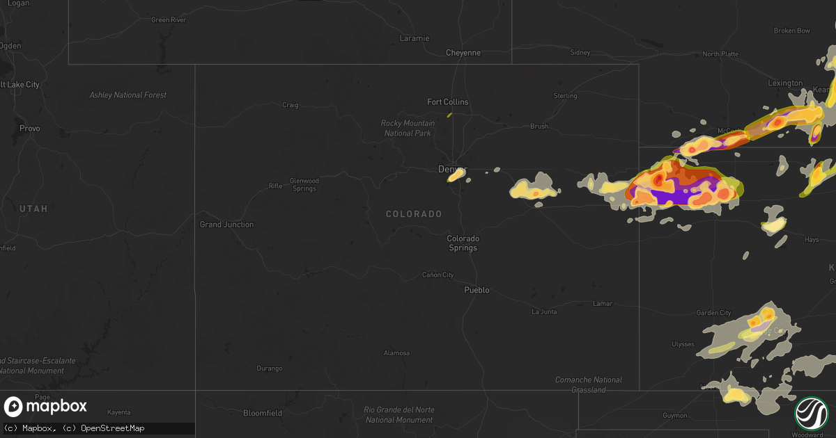
Hail Map in Colorado on June 14, 2014
Get this storm
June 14 map
$229
one time, instant access
Download today. No call, no setup
Keep the $229
Bought the map and want the full workflow? Apply the entire $229 to a subscription within 7 days. None of it is wasted.
Every map, not just this one
This buys you this map. Subscription and you get every map we run, in the markets you choose from a few cities to whole states to nationwide. Plus real-time alerts the moment a storm fires.
Contact data
Name, contact info, occupancy, even credit band for addresses in the footprint. You go from where it hit to who to call.
Become the source they trust
Unlimited branding weather history reports on demand. You already have the documented answer ready for the property owner, and you are the one who showed up with it.
Property data and RoofTrace estimates
Pull up any address you have got, its value and the exact code rules for that jurisdiction, straight from One Click Code. Then RoofTrace estimates the squares, pitch, and roof value, priced the way you price.
Storm reports in Colorado
Colorado
| Date | Description |
|---|---|
| 06/14/20146:55 PM CDT | Estimated 60 mph wind gusts and pea to dime size hail covering the ground. |
| 06/14/20146:50 PM CDT | Estimated wind gust between 60 and 70 mph. Small limbs down. |
| 06/14/20146:17 PM CDT | A local report indicates 1.25 inch wind near 2 N LIMON |
| 06/14/20146:12 PM CDT | A local report indicates 1.75 inch wind near 12 N LIMON |
| 06/14/20146:11 PM CDT | Tornado was reported at county roads m and 2 in southwestern washington county. No damage reported |
| 06/14/20145:32 PM CDT | A local report indicates 1.00 inch wind near 1 ESE THE PINERY |
| 06/14/20145:29 PM CDT | A local report indicates 1.50 inch wind near AGATE |
| 06/14/20145:26 PM CDT | A local report indicates 1.00 inch wind near 2 NW STRASBURG |
| 06/14/20144:44 PM CDT | A local report indicates 1.00 inch wind near 4 SE DENVER |
| 06/14/20144:35 PM CDT | A local report indicates 1.00 inch wind near 3 SE DENVER |
| 06/14/20144:34 PM CDT | A local report indicates 1.50 inch wind near 1 SE ENGLEWOOD |
| 06/14/20144:32 PM CDT | A local report indicates 1.75 inch wind near 1 SE ENGLEWOOD |
| 06/14/20144:30 PM CDT | 2 1/8 inch hail |
| 06/14/20144:30 PM CDT | A local report indicates 1.00 inch wind near 1 SSE GREENWOOD VILLAGE |
| 06/14/20144:29 PM CDT | A local report indicates 1.00 inch wind near 2 NNE HIGHLANDS RANCH |
| 06/14/20144:27 PM CDT | A local report indicates 1.50 inch wind near 1 SE ENGLEWOOD |
| 06/14/20144:00 PM CDT | A local report indicates 1.00 inch wind near 3 SSE DENVER |
| 06/14/20143:43 PM CDT | A local report indicates 1.00 inch wind near LOVELAND |
| 06/13/20147:54 PM CDT | A local report indicates 1.00 inch wind near 1 S WRAY |
| 06/13/20147:53 PM CDT | A local report indicates 64 MPH wind near WRAY |
| 06/13/20147:50 PM CDT | A local report indicates 58 MPH wind near STRATTON |
| 06/13/20147:45 PM CDT | Trees and powerlines down in wray. Time estimated. |
| 06/13/20147:45 PM CDT | A local report indicates 78 MPH wind near 4 S BURLINGTON |
| 06/13/20147:43 PM CDT | A local report indicates 63 MPH wind near 6 E KIRK |
| 06/13/20147:40 PM CDT | Trees and powerlines down. Pivots damaged. Time estimated by radar. |
| 06/13/20147:35 PM CDT | A local report indicates 73 MPH wind near STRATTON |
| 06/13/20147:30 PM CDT | Late report. |
| 06/13/20147:30 PM CDT | Mix of small and large hail. Largest hailstone estimated to be one and a half inches in diameter. |
| 06/13/20147:30 PM CDT | Late report. Large tree down. Damage to irrigation pivots. Grain bin destroyed. Golf ball size hail also occurred. Damage to corn and wheat crops from the wind and/or h |
| 06/13/20147:26 PM CDT | Many tree limbs down 3 inches in diameter or smaller. Time estimated from radar. |
| 06/13/20147:21 PM CDT | A local report indicates 73 MPH wind near 17 N VONA |
| 06/13/20147:20 PM CDT | A local report indicates 62 MPH wind near 17 N VONA |
| 06/13/20147:16 PM CDT | A local report indicates 1.00 inch wind near S LIMON |
| 06/13/20147:12 PM CDT | Also reports nickle size hail. |
| 06/13/20147:07 PM CDT | A local report indicates 1.75 inch wind near 1 N LIMON |
| 06/13/20147:02 PM CDT | A local report indicates 1.75 inch wind near 1 WNW LIMON |
All States Impacted by Hail Map on June 14, 2014
Cities Impacted by Hail Map on June 14, 2014
- Brewster, KS
- Archer, NE
- Fullerton, NE
- Central City, NE
- Clarks, NE
- Genoa, NE
- Silver Creek, NE
- Goodland, KS
- Kanorado, KS
- Ensign, KS
- Satanta, KS
- Sublette, KS
- Pierceville, KS
- Copeland, KS
- Wright, KS
- Ulysses, KS
- Garden City, KS
- Dodge City, KS
- Hanston, KS
- Plains, KS
- Ford, KS
- Jetmore, KS
- Cimarron, KS
- Spearville, KS
- Meade, KS
- Montezuma, KS
- Minneola, KS
- Fowler, KS
- Ingalls, KS
- Bucklin, KS
- Offerle, KS
- Colby, KS
- Stockton, KS
- Glade, KS
- Phillipsburg, KS
- Kirwin, KS
- Bethune, CO
- Glenvil, NE
- Inland, NE
- Burlington, CO
- Hastings, NE
- Juniata, NE
- Littleton, CO
- Englewood, CO
- Denver, CO
- Aurora, CO
- Culbertson, NE
- Stratton, NE
- Atwood, KS
- McDonald, KS
- Trenton, NE
- Arriba, CO
- Genoa, CO
- Limon, CO
- Woodrow, CO
- Deer Trail, CO
- Agate, CO
- Lindon, CO
- Kearney, NE
- Gibbon, NE
- Shelton, NE
- Saint Francis, KS
- Doniphan, NE
- Roseland, NE
- Aurora, NE
- Ayr, NE
- Giltner, NE
- Trumbull, NE
- Englewood, KS
- Albion, NE
- Draper, SD
- Vivian, SD
- White River, SD
- Presho, SD
- Edson, KS
- Magnet, NE
- Randolph, NE
- Arapahoe, NE
- Edison, NE
- Herndon, KS
- Gem, KS
- North Loup, NE
- Ord, NE
- Mclean, NE
- Pierce, NE
- Osmond, NE
- Grand Island, NE
- Minden, NE
- Ravenna, NE
- Newman Grove, NE
- Bird City, KS
- Atlanta, NE
- Holdrege, NE
- Bertrand, NE
- Blue Hill, NE
- Phillips, NE
- Wood River, NE
- Idalia, CO
- Lamesa, TX
- Ackerly, TX
- Wakeeney, KS
- McCook, NE
- Alda, NE
- Lenora, KS
- Almena, KS
- Norton, KS
- Liberal, KS
- Hugoton, KS
- Forgan, OK
- Rosston, OK
- Buffalo, OK
- Beaver, OK
- Ashland, KS
- Gate, OK
- Laverne, OK
- Kismet, KS
- Turpin, OK
- Eustis, NE
- Vona, CO
- Seibert, CO
- Stratton, CO
- Rexford, KS
- Selden, KS
- Hoxie, KS
- Levant, KS
- Ashton, NE
- Elba, NE
- Farwell, NE
- Rockville, NE
- Boelus, NE
- Pleasanton, NE
- Danbury, NE
- Indianola, NE
- Palmer, NE
- Cairo, NE
- Elwood, NE
- Concord, NE
- Carroll, NE
- Laurel, NE
- Belden, NE
- Wayne, NE
- Harrisburg, SD
- Glenrock, WY
- Agra, KS
- Strasburg, CO
- Byers, CO
- Oxford, NE
- Alma, NE
- Wilcox, NE
- Holbrook, NE
- Wilsonville, NE
- Funk, NE
- Loomis, NE
- Cambridge, NE
- Orleans, NE
- Axtell, NE
- Bennett, CO
- Hazard, NE
- Haviland, KS
- Coldwater, KS
- Mullinville, KS
- Protection, KS
- Wilmore, KS
- Sun City, KS
- Fleming, GA
- Richmond Hill, GA
- Midway, GA
- Fordyce, NE
- Volin, SD
- Wynot, NE
- Saint Helena, NE
- Gayville, SD
- Wakonda, SD
- Vermillion, SD
- Hartington, NE
- Saint Libory, NE
- Chapman, NE
- Harvard, NE
- Ogallah, KS
- Hill City, KS
- Collyer, KS
- Scenic, SD
- Pine Ridge, SD
- Hermosa, SD
- Hampton, NE
- Litchfield, NE
- Emerson, NE
- Kenesaw, NE
- Saint Edward, NE
- Wausa, NE
- Wakefield, NE
- Kensington, KS
- Oakley, KS
- Smithfield, NE
- Campbell, NE
- Scotia, NE
- Lebanon, KS
- Smith Center, KS
- Lebanon, NE
- Polk, NE
- Yankton, SD
- South Sioux City, NE
- Flagler, CO
- Inavale, NE
- Prairie View, KS
- Mission Hill, SD
- Norfolk, NE
- Sharon Springs, KS
- Holstein, NE
- Neligh, NE
- Gaylord, KS
- Waterbury, NE
- Upland, NE
- Dannebrog, NE
- Logan, KS
- Hordville, NE
- Jefferson, SD
- Weskan, KS
- Dixon, NE
- Cedar Rapids, NE
- Ponca, NE
- Hoskins, NE
- Petersburg, NE
- Lawrence, NE
- Cope, CO
- Heartwell, NE
- Stromsburg, NE
- Overton, NE
- Red Cloud, NE
- Bladen, NE
- Lindsay, NE
- Kirk, CO
- North Sioux City, SD
- Cedar, KS
- Newcastle, NE
- Dakota City, NE
- Hildreth, NE
- Max, NE
- Bartley, NE
- Saint Paul, NE
- Plainview, NE
- Marquette, NE
- Battle Creek, NE
- Madison, NE
- Belgrade, NE
- Naponee, NE
- Winside, NE
- Hubbard, NE
- Humphrey, NE
- Joes, CO
- Osceola, NE
- Crofton, NE
- Allen, NE
- Republican City, NE
- Meadow Grove, NE
- Tilden, NE
- Elm Creek, NE
- Wolbach, NE
- Homer, NE
- Coleridge, NE
- Loup City, NE
- Athol, KS
- Jackson, NE
- Wanblee, SD
- Long Valley, SD
- Lance Creek, WY
- Wallace, KS
- Sioux Falls, SD
- Tea, SD
- Lusk, WY
- Kaycee, WY
- Gillette, WY
- Amherst, NE
- Mason City, NE
- Oberlin, KS
- Murdo, SD
- Wood, SD
- Canton, SD
- Lennox, SD
- Worthing, SD
- Winona, KS
- Dryden, TX
- Morland, KS
- Ellis, KS
- Penokee, KS
- Rockwell City, IA
- Fonda, IA
- Beaver City, NE
- Pocahontas, IA
- Bronson, IA
- Benkelman, NE
- Hudson, SD
- Beresford, SD
- Larchwood, IA
- Centerville, SD
- Inwood, IA
- Davis, SD
- Dighton, KS
- Savannah, GA
- Fort Pierce, FL
- Port Saint Lucie, FL
- Palisade, NE
- Lake City, IA
- Loveland, CO
- Dresden, KS
- Kennebec, SD
- Hendley, NE
- Riverton, NE


