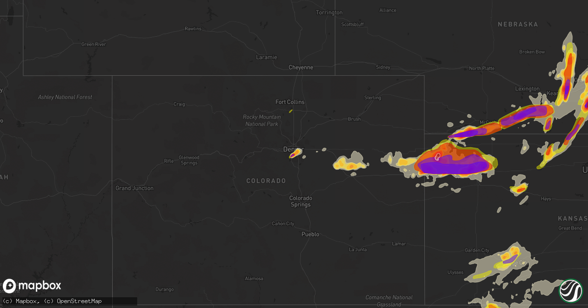
Hail Map on June 14, 2014
Get this storm
June 14 map
$229
one time, instant access
Download today. No call, no setup
Keep the $229
Bought the map and want the full workflow? Apply the entire $229 to a subscription within 7 days. None of it is wasted.
Every map, not just this one
This buys you this map. Subscription and you get every map we run, in the markets you choose from a few cities to whole states to nationwide. Plus real-time alerts the moment a storm fires.
Contact data
Name, contact info, occupancy, even credit band for addresses in the footprint. You go from where it hit to who to call.
Become the source they trust
Unlimited branding weather history reports on demand. You already have the documented answer ready for the property owner, and you are the one who showed up with it.
Property data and RoofTrace estimates
Pull up any address you have got, its value and the exact code rules for that jurisdiction, straight from One Click Code. Then RoofTrace estimates the squares, pitch, and roof value, priced the way you price.
States Impacted by Hail Map on June 14, 2014
Storm reports
Colorado
| Date | Description |
|---|---|
| 06/14/20146:55 PM CDT | Estimated 60 mph wind gusts and pea to dime size hail covering the ground. |
| 06/14/20146:50 PM CDT | Estimated wind gust between 60 and 70 mph. Small limbs down. |
| 06/14/20146:17 PM CDT | A local report indicates 1.25 inch wind near 2 N LIMON |
| 06/14/20146:12 PM CDT | A local report indicates 1.75 inch wind near 12 N LIMON |
| 06/14/20146:11 PM CDT | Tornado was reported at county roads m and 2 in southwestern washington county. No damage reported |
| 06/14/20145:32 PM CDT | A local report indicates 1.00 inch wind near 1 ESE THE PINERY |
| 06/14/20145:29 PM CDT | A local report indicates 1.50 inch wind near AGATE |
| 06/14/20145:26 PM CDT | A local report indicates 1.00 inch wind near 2 NW STRASBURG |
| 06/14/20144:44 PM CDT | A local report indicates 1.00 inch wind near 4 SE DENVER |
| 06/14/20144:35 PM CDT | A local report indicates 1.00 inch wind near 3 SE DENVER |
| 06/14/20144:34 PM CDT | A local report indicates 1.50 inch wind near 1 SE ENGLEWOOD |
| 06/14/20144:32 PM CDT | A local report indicates 1.75 inch wind near 1 SE ENGLEWOOD |
| 06/14/20144:30 PM CDT | A local report indicates 1.00 inch wind near 1 SSE GREENWOOD VILLAGE |
| 06/14/20144:30 PM CDT | 2 1/8 inch hail |
| 06/14/20144:29 PM CDT | A local report indicates 1.00 inch wind near 2 NNE HIGHLANDS RANCH |
| 06/14/20144:27 PM CDT | A local report indicates 1.50 inch wind near 1 SE ENGLEWOOD |
| 06/14/20144:00 PM CDT | A local report indicates 1.00 inch wind near 3 SSE DENVER |
| 06/14/20143:43 PM CDT | A local report indicates 1.00 inch wind near LOVELAND |
| 06/13/20147:54 PM CDT | A local report indicates 1.00 inch wind near 1 S WRAY |
| 06/13/20147:53 PM CDT | A local report indicates 64 MPH wind near WRAY |
| 06/13/20147:50 PM CDT | A local report indicates 58 MPH wind near STRATTON |
| 06/13/20147:45 PM CDT | Trees and powerlines down in wray. Time estimated. |
| 06/13/20147:45 PM CDT | A local report indicates 78 MPH wind near 4 S BURLINGTON |
| 06/13/20147:43 PM CDT | A local report indicates 63 MPH wind near 6 E KIRK |
| 06/13/20147:40 PM CDT | Trees and powerlines down. Pivots damaged. Time estimated by radar. |
| 06/13/20147:35 PM CDT | A local report indicates 73 MPH wind near STRATTON |
| 06/13/20147:30 PM CDT | Late report. |
| 06/13/20147:30 PM CDT | Late report. Large tree down. Damage to irrigation pivots. Grain bin destroyed. Golf ball size hail also occurred. Damage to corn and wheat crops from the wind and/or h |
| 06/13/20147:30 PM CDT | Mix of small and large hail. Largest hailstone estimated to be one and a half inches in diameter. |
| 06/13/20147:26 PM CDT | Many tree limbs down 3 inches in diameter or smaller. Time estimated from radar. |
| 06/13/20147:21 PM CDT | A local report indicates 73 MPH wind near 17 N VONA |
| 06/13/20147:20 PM CDT | A local report indicates 62 MPH wind near 17 N VONA |
| 06/13/20147:16 PM CDT | A local report indicates 1.00 inch wind near S LIMON |
| 06/13/20147:12 PM CDT | Also reports nickle size hail. |
| 06/13/20147:07 PM CDT | A local report indicates 1.75 inch wind near 1 N LIMON |
| 06/13/20147:02 PM CDT | A local report indicates 1.75 inch wind near 1 WNW LIMON |
Kansas
| Date | Description |
|---|---|
| 06/14/20146:58 PM CDT | Hail did not last long. Largest was quarter size. |
| 06/14/20146:33 PM CDT | Hail covering the ground. Report rcvd via web entry. |
| 06/14/20146:07 PM CDT | Report received via web entry. |
| 06/14/20146:00 PM CDT | Public report of golf ball sized hail e and ne of glade. |
| 06/14/20145:33 PM CDT | Confirmed photo landspout tornado via twitter. Time and location estimated from radar. Received photo at 539 pm. |
| 06/14/20145:33 PM CDT | Multiple reports of possible tornado. Condensation funnel half way to the ground with swirling dust at the ground. One storm chaser reported it was on the ground for 3- |
| 06/14/201411:57 AM CDT | 6 to 7 inch diameter tree limbs blown down. |
| 06/14/20143:55 AM CDT | Several trees down across college blvd in lenexa. |
| 06/14/20143:40 AM CDT | Trees uprooted... Damage to roof of high school and numerous power lines down over a large swath of wellsville. Time is approximate. |
| 06/14/20143:12 AM CDT | 3 large trees 20 inches in diameter down at 251st street and fairmont... |
| 06/14/20142:55 AM CDT | Trees blown down. Storage unit destroyed. Electrical power out. Time estimated from radar data. |
| 06/14/20142:25 AM CDT | Six inch tree limbs reported down at northeast 50th and rochester. |
| 06/14/20142:20 AM CDT | 3 inch tree limbs downed. |
| 06/14/20142:20 AM CDT | 3 inch tree limbs downed. |
| 06/14/20142:09 AM CDT | Three power poles leaning over onto carlson road. |
| 06/14/20141:55 AM CDT | Time estimated per doppler. Winds occurred along the thunderstorm gust front. |
| 06/14/20141:50 AM CDT | Tree branches down. Time estimated based on radar data. |
| 06/14/20141:47 AM CDT | A local report indicates 60 MPH wind near 10 S JUNCTION CITY |
| 06/14/20141:45 AM CDT | Tree limbs and power lines downed in the city. |
| 06/14/20141:22 AM CDT | 8 to 10 inch diamaeter limbs down... Telephone pole broke abd machine shed flattened. Time approximate. |
| 06/14/20141:22 AM CDT | A local report indicates 72 MPH wind near 2 NNE JUNCTION CITY |
| 06/14/20141:15 AM CDT | Tree limb feel on power line. |
| 06/14/20141:14 AM CDT | Power was also out. |
| 06/14/20141:08 AM CDT | Had debris flying around but could not go outside to look closer. |
| 06/14/20141:07 AM CDT | A local report indicates 60 MPH wind near HAVEN |
| 06/14/20141:06 AM CDT | Many tree limbs down around 3 inches in diameter. |
| 06/14/20141:05 AM CDT | 6 to 8 inch limbs blown down. Time is approximate. |
| 06/14/20141:03 AM CDT | Zero visibility with gusts to 70 |
| 06/14/20141:00 AM CDT | Lasting from approximately 100 to 115 am the estimated 70 mph winds caused tree damage. |
| 06/14/201412:51 AM CDT | Reported tree limbs down on house...size unknown. Also had some power flashes. |
| 06/14/201412:45 AM CDT | A local report indicates 70 MPH wind near 1 W NICKERSON |
| 06/14/201412:45 AM CDT | 6 inch tree limbs down. Estimated winds gusts as high as 75 mph. |
| 06/14/201412:45 AM CDT | A local report indicates 60 MPH wind near STERLING |
| 06/14/201412:45 AM CDT | A local report indicates 1.00 inch wind near 1 W ST. JOHN |
| 06/14/201412:43 AM CDT | Brief power loss and small tree limbs down. |
| 06/14/201412:40 AM CDT | Lots of tree limb damage. Branches 5 to 6 inches in diameter down across the town. |
| 06/14/201412:40 AM CDT | Reported tree limbs down. |
| 06/14/201412:32 AM CDT | 5 to 6 inch diameter limbs down |
| 06/14/201412:32 AM CDT | Estimated 60+ mph winds |
| 06/14/201412:30 AM CDT | Sheriff reports there is tree and structural damage in town. |
| 06/14/201412:21 AM CDT | A local report indicates 65 MPH wind near 4 ENE ADA |
| 06/14/201412:17 AM CDT | Large tree downed in the city. |
| 06/14/201412:15 AM CDT | A local report indicates 67 MPH wind near CONCORDIA AIRPORT |
| 06/14/201412:09 AM CDT | Power lines downed. Law enforement reported power was out in belleville. |
| 06/14/201412:00 AM CDT | Estimated 60 to 70 mph winds. |
| 06/13/201411:58 PM CDT | A local report indicates 70 MPH wind near PAWNEE ROCK |
| 06/13/201411:57 PM CDT | 6 to 7 inch diameter tree limbs blown down. |
| 06/13/201411:51 PM CDT | A local report indicates 65 MPH wind near 1 NE SYLVAN GROVE |
| 06/13/201411:50 PM CDT | A local report indicates 65 MPH wind near 4 ESE LUCAS |
| 06/13/201411:49 PM CDT | Asos |
| 06/13/201411:48 PM CDT | 59 mph |
| 06/13/201411:47 PM CDT | Gust was measured at east end of wilson lake. |
| 06/13/201411:46 PM CDT | Home wx station recorded 77 mph wind gust |
| 06/13/201411:45 PM CDT | Asos |
| 06/13/201411:44 PM CDT | 71 mph. Winds on back edge of convective line. |
| 06/13/201411:38 PM CDT | Ks state university. |
| 06/13/201411:38 PM CDT | Several photos rcvd via facebook of large tree limbs snapped. One was approx 12 inches in diameter. Another was approx 18 inches in diameter which landed on a wood post |
| 06/13/201411:35 PM CDT | Delayed report of estimated 70 mph winds that broke a few large tree limbs |
| 06/13/201411:32 PM CDT | Krsl asos |
| 06/13/201411:27 PM CDT | A local report indicates 66 MPH wind near LOGAN |
| 06/13/201411:25 PM CDT | A local report indicates 70 MPH wind near BURR OAK |
| 06/13/201411:25 PM CDT | Ks dot rwis site. |
| 06/13/201411:18 PM CDT | 50 knots or 58 mph gust was reported by the hays asos |
| 06/13/201411:06 PM CDT | Awos reported 68 mph at 2306l |
| 06/13/201411:05 PM CDT | Public reported 80 mph wind gust at 2305l |
| 06/13/201411:03 PM CDT | A local report indicates 1.00 inch wind near COPELAND |
| 06/13/201411:03 PM CDT | A local report indicates 2.00 inch wind near 12 N DODGE CITY |
| 06/13/201411:03 PM CDT | A local report indicates 80 MPH wind near 12 N DODGE CITY |
| 06/13/201410:56 PM CDT | A local report indicates 60 MPH wind near PLAINVILLE |
| 06/13/201410:55 PM CDT | A large 12.5 inch tree branch feel on a car at 5th street and a avenue. |
| 06/13/201410:55 PM CDT | A local report indicates 65 MPH wind near MONTEZUMA |
| 06/13/201410:55 PM CDT | A 12 x 20 foot metal horse barn was blown over the railraod tracks on 22 road and u-50. |
| 06/13/201410:54 PM CDT | A local report indicates 1.75 inch wind near 2 WNW HOWELL |
| 06/13/201410:51 PM CDT | Broken tree limbs and large trees are down. No exact size on trees down but they need to be removed with heavy equipment. A lot of debris has been blown around. |
| 06/13/201410:50 PM CDT | Report was from a kdot road and runway weatehr information system. |
| 06/13/201410:50 PM CDT | A local report indicates 65 MPH wind near S MONTEZUMA |
| 06/13/201410:50 PM CDT | Rcvd multiple photos. One large tree uprooted. Others snapped off at the trunk 5 to 7 ft above the ground. Two in particular appeared to be 18-24 inches in diameter. La |
| 06/13/201410:47 PM CDT | A local report indicates 78 MPH wind near HILL CITY |
| 06/13/201410:45 PM CDT | A local report indicates 64 MPH wind near 5 S STOCKTON |
| 06/13/201410:40 PM CDT | Delayed report of wind damage...campers blown over and roof blown off 1 cabin. Time adjusted to radar data. |
| 06/13/201410:40 PM CDT | A local report indicates 1.75 inch wind near WAKEENEY |
| 06/13/201410:40 PM CDT | A local report indicates 75 MPH wind near HILL CITY |
| 06/13/201410:40 PM CDT | A local report indicates 80 MPH wind near WAKEENEY |
| 06/13/201410:37 PM CDT | Peak sustained winds 67 mph. |
| 06/13/201410:33 PM CDT | 60-70mph wind...large hail...windows all windows knocked out of vehicle |
| 06/13/201410:32 PM CDT | A local report indicates 1.75 inch wind near WAKEENEY |
| 06/13/201410:32 PM CDT | Nickle sized hail and winds est 50 to 60 mph |
| 06/13/201410:30 PM CDT | A local report indicates 80 MPH wind near 3 S LONG ISLAND |
| 06/13/201410:28 PM CDT | A local report indicates 80 MPH wind near HEALY |
| 06/13/201410:28 PM CDT | A local report indicates 80 MPH wind near DIGHTON |
| 06/13/201410:27 PM CDT | Corrected time. |
| 06/13/201410:21 PM CDT | Spotter reported 70mph wind gust rocking truck. |
| 06/13/201410:21 PM CDT | 2 inch tree limbs down and damage to a fence. |
| 06/13/201410:20 PM CDT | Playground equipment has been blown over inside the town. |
| 06/13/201410:18 PM CDT | A local report indicates 78 MPH wind near NORTON |
| 06/13/201410:17 PM CDT | Jj oil building... Cars... And colonial steakhouse in oakley had windows blown out and broken. A semi was blown over at mile marker 111. Numerous trees are down and people (g |
| 06/13/201410:14 PM CDT | A local report indicates 69 MPH wind near HILL CITY |
| 06/13/201410:12 PM CDT | A local report indicates 73 MPH wind near NORTON |
| 06/13/201410:07 PM CDT | A local report indicates 67 MPH wind near ALMENA |
| 06/13/201410:07 PM CDT | Many 2-3 ft. Diameter trees snapped off. One pine tree uprooted. 3-4 houses had trees fall on them. 1-2 vehicles smashed under trees. Partial roof blown off of one hous |
| 06/13/201410:04 PM CDT | A local report indicates 60 MPH wind near ALMENA |
| 06/13/201410:03 PM CDT | A local report indicates 59 MPH wind near NORTON |
| 06/13/201410:02 PM CDT | Estimated 70 to 80 mph wind. |
| 06/13/201410:00 PM CDT | Elevator leg and grain bin blown over in norcatur. Many 6-8 inch diameter limbs blown down. Time estimated from radar. |
| 06/13/201410:00 PM CDT | Trees and powerlines down countywide. |
| 06/13/20149:55 PM CDT | 6-8 inch diameter limbs blown down. Time estimated from radar. |
| 06/13/20149:53 PM CDT | A local report indicates 61 MPH wind near 5 SE GOVE |
| 06/13/20149:50 PM CDT | Late report received via social media. Roof and siding damage to houses. Trees on houses. Grain bin damaged. Time estimated using radar. |
| 06/13/20149:45 PM CDT | 6-8 inch diameter tree limbs down. Also had .80 inches of rainfall. Time estimated from radar. |
| 06/13/20149:45 PM CDT | Time estimated from radar. |
| 06/13/20149:45 PM CDT | Half a tree was blown over blocking entrance to buffalo park. Carport on outside of town was blown into power lines causing hoxie to lose power. |
| 06/13/20149:43 PM CDT | A local report indicates 58 MPH wind near COLBY |
| 06/13/20149:40 PM CDT | Time estimated by radar |
| 06/13/20149:37 PM CDT | Tree was uprooted. Time estimated from radar. |
| 06/13/20149:31 PM CDT | A local report indicates 67 MPH wind near GRINNELL |
| 06/13/20149:30 PM CDT | 2 to 3 inch tree limbs down. |
| 06/13/20149:28 PM CDT | A local report indicates 1.00 inch wind near 15 S DEERFIELD |
| 06/13/20149:27 PM CDT | A local report indicates 60 MPH wind near COLBY |
| 06/13/20149:27 PM CDT | 70 mph winds and 0.60 inches of rain. |
| 06/13/20149:27 PM CDT | A local report indicates 70 MPH wind near 2 NE COLBY |
| 06/13/20149:25 PM CDT | Numerous tree branches down in atwood. Large tree blocking highway 25. Via spotter network. Time estimated by radar. |
| 06/13/20149:24 PM CDT | Some tree damage. Delayed report. Time estimated from radar. |
| 06/13/20149:23 PM CDT | Dust and dirt are blowing around with strong winds. |
| 06/13/20149:22 PM CDT | A local report indicates 70 MPH wind near OAKLEY |
| 06/13/20149:21 PM CDT | Measured by a davis weather station. |
| 06/13/20149:20 PM CDT | Report via social media |
| 06/13/20149:20 PM CDT | Report via social media. |
| 06/13/20149:20 PM CDT | Numerous power poles down countywide. |
| 06/13/20149:20 PM CDT | Windows broken out at the travel stop on i70...minor injuries reported from flying glass. Time estimated from radar. |
| 06/13/20149:18 PM CDT | A local report indicates 61 MPH wind near ST. FRANCIS |
| 06/13/20149:17 PM CDT | Via spotter network. |
| 06/13/20149:15 PM CDT | Shingles blown off house and 6 inch diameter tree limbs down |
| 06/13/20149:14 PM CDT | A local report indicates 67 MPH wind near 4 S DANBURY |
| 06/13/20149:14 PM CDT | A local report indicates 70 MPH wind near OAKLEY |
| 06/13/20149:14 PM CDT | Measured four or five 10-12 inch diameter healthy tree limbs blown down. |
| 06/13/20149:13 PM CDT | A local report indicates 79 MPH wind near ATWOOD |
| 06/13/20149:11 PM CDT | 3.00 inch hail fell near 4th and range in colby. Report via social media. |
| 06/13/20149:09 PM CDT | A local report indicates 69 MPH wind near 7 NNW GEM |
| 06/13/20149:08 PM CDT | A local report indicates 2.50 inch wind near 2 E LEVANT |
| 06/13/20149:08 PM CDT | Report via social media. |
| 06/13/20149:04 PM CDT | A local report indicates 89 MPH wind near 4 N ATWOOD |
| 06/13/20149:04 PM CDT | A local report indicates 60 MPH wind near 5 NW ULYSSES |
| 06/13/20149:04 PM CDT | A local report indicates 58 MPH wind near GOODLAND |
| 06/13/20149:03 PM CDT | A local report indicates 1.75 inch wind near 4 N COLBY |
| 06/13/20149:02 PM CDT | A local report indicates 58 MPH wind near 2 NE COLBY |
| 06/13/20149:00 PM CDT | A local report indicates 3.00 inch wind near 4 W COLBY |
| 06/13/20149:00 PM CDT | Top half of trees blown down. Estimated a couple hundred trees a foot in diameter or larger blown down. Time estimated from radar |
| 06/13/20148:53 PM CDT | A local report indicates 1.75 inch wind near 3 S LEVANT |
| 06/13/20148:50 PM CDT | Late report. 10 inch diameter cedar tree down on the south side of bird city. Time estimated by radar. |
| 06/13/20148:49 PM CDT | A local report indicates 60 MPH wind near BIRD CITY |
| 06/13/20148:48 PM CDT | From social media. |
| 06/13/20148:45 PM CDT | A local report indicates 1.00 inch wind near BREWSTER |
| 06/13/20148:45 PM CDT | Late report. 5 power poles down on road 28 between road i and j. Time estimated by radar. |
| 06/13/20148:40 PM CDT | Two irrigation pivots turned over near county road 27 and road d. Time estimated from radar. |
| 06/13/20148:40 PM CDT | Late report. 5 power poles down at road d and road 27. Wheat crop damaged by hail of unknown size just south of this location near road a and road 28. Time estimated by |
| 06/13/20148:39 PM CDT | 0 visibility with rain and hail is winding down but still 1.00 inch to about half dollar size. |
| 06/13/20148:35 PM CDT | Also estimated 70 mph wind with one quarter to one half mile visibility from blowing dust. |
| 06/13/20148:35 PM CDT | Also estimated 70 mph wind with one quarter to one half mile visibility from blowing dust. |
| 06/13/20148:35 PM CDT | A local report indicates 2.50 inch wind near 13 N ATWOOD |
| 06/13/20148:35 PM CDT | Late report. Irrigation pivot damaged near road 28 and road 76. Time estimated by radar. |
| 06/13/20148:35 PM CDT | Eight inch tree limb downed. |
| 06/13/20148:34 PM CDT | A local report indicates 2.75 inch wind near 11 N ATWOOD |
| 06/13/20148:30 PM CDT | Overturned pivot and multiple power poles snapped near road d and road 27. Time estimated by radar. |
| 06/13/20148:30 PM CDT | Relayed by rawlins county dispatch. |
| 06/13/20148:28 PM CDT | A local report indicates 1.75 inch wind near 10 NW ATWOOD |
| 06/13/20148:25 PM CDT | A local report indicates 75 MPH wind near ST. FRANCIS |
| 06/13/20148:24 PM CDT | A local report indicates 75 MPH wind near ST. FRANCIS |
| 06/13/20148:24 PM CDT | 60 mph wind gust with visibility down to about 1 mile in blowing dust. |
| 06/13/20148:21 PM CDT | Baseball size hail at the nws office. |
| 06/13/20148:20 PM CDT | Delayed report received from spotter network. |
| 06/13/20148:20 PM CDT | Golf ball size hail on 24 west of goodland. |
| 06/13/20148:19 PM CDT | Mostly nickel size hail. Some golf ball size. Also measured 55 mph wind. |
| 06/13/20148:18 PM CDT | A local report indicates 76 MPH wind near 9 SE BEECHER ISLAND |
| 06/13/20148:17 PM CDT | Also quarter size hail. |
| 06/13/20148:15 PM CDT | Delayed report of several large trees down and golf ball size hail near road 76 and road 8. Time estimated by radar. |
| 06/13/20148:15 PM CDT | A local report indicates 59 MPH wind near ST. FRANCIS |
| 06/13/20148:12 PM CDT | Grain bins leveled from wind and baseball size hail. |
| 06/13/20148:12 PM CDT | Golf ball size hail and strong winds causing blowing dust and visibility less than a quarter mile. |
| 06/13/20148:07 PM CDT | A local report indicates 2.75 inch wind near KANORADO |
| 06/13/20148:06 PM CDT | A local report indicates 67 MPH wind near 9 SE BEECHER ISLAND |
| 06/13/20148:02 PM CDT | A local report indicates 2.50 inch wind near KANORADO |
| 06/13/20148:00 PM CDT | 2.00 inch hail reported by the fire chief in kanorado. Report relayed by law enforcement. |
| 06/13/20147:59 PM CDT | Hail size ranged from golf ball to baseball size. |
| 06/13/20147:58 PM CDT | A local report indicates 70 MPH wind near 13 NW ST. FRANCIS |
Florida
| Date | Description |
|---|---|
| 06/14/20144:36 PM CDT | Tree on a power line reported at 34 brewster lane in palm coast. |
| 06/14/20143:00 PM CDT | Trained spotter reported wooden fences blown down...cabbage palms 1.5 feet in diameter snapped...and hardwood trees 2 feet in diameter snapped 2 miles northwest of lion |
South Dakota
| Date | Description |
|---|---|
| 06/14/20146:45 PM CDT | A local report indicates 1.50 inch wind near 4 SSE MISSION HILL |
| 06/14/201412:45 PM CDT | Ping pong hail. |
| 06/14/201412:20 PM CDT | A local report indicates 62 MPH wind near 1 NE MIDLAND |
| 06/14/201411:35 AM CDT | A local report indicates 60 MPH wind near 8 S KADOKA |
| 06/14/20149:00 AM CDT | A local report indicates 70 MPH wind near 6 E PHILIP |
| 06/14/20148:10 AM CDT | Camper flipped at mile marker 120 on interstate 90. |
| 06/14/20147:48 AM CDT | Pinnacles raws |
| 06/14/20147:20 AM CDT | A local report indicates 1.00 inch wind near 9 NE SCENIC |
| 06/14/20147:20 AM CDT | A local report indicates 60 MPH wind near 9 NE SCENIC |
| 06/13/20148:55 PM CDT | A local report indicates 1.75 inch wind near HARRISBURG |
| 06/13/20148:30 PM CDT | A local report indicates 60 MPH wind near 9 W PROVO |
| 06/13/20147:26 PM CDT | A local report indicates 1.00 inch wind near CANTON |
Wyoming
| Date | Description |
|---|---|
| 06/14/20145:57 PM CDT | A local report indicates 1.00 inch wind near 24 SSW SAVAGETON |
| 06/13/20148:25 PM CDT | Wind gusts to 60 mph. Blew shingles off the roof and damaged trees. |
| 06/13/20148:15 PM CDT | A local report indicates 1.75 inch wind near REDBIRD |
Georgia
| Date | Description |
|---|---|
| 06/14/20145:07 PM CDT | Bryan county dispatch reported a tree down at the intersection of highway 144 and strathy hall road. Time estimated by radar. |
| 06/14/20144:26 PM CDT | Media reported a tree down on powerlines on skidaway road. Time estimated by radar. |
| 06/14/20144:24 PM CDT | Spotter reported quarter size hail near ash street and 52nd street. |
Minnesota
| Date | Description |
|---|---|
| 06/13/20147:37 PM CDT | Delayed report. 3 to 4 trees... Powerline down. Time estimated. |
Iowa
| Date | Description |
|---|---|
| 06/14/20144:10 PM CDT | A number of 4 inch diameter trees and tree branches down in town. Likely a combination of the strong synoptic winds enhanced by a thunderstorm outflow just to the south |
| 06/13/201410:05 PM CDT | A local report indicates 60 MPH wind near 1 W CLEGHORN |
Nebraska
| Date | Description |
|---|---|
| 06/14/20146:57 PM CDT | A local report indicates 1.75 inch wind near ALBION |
| 06/14/20146:50 PM CDT | A local report indicates 1.75 inch wind near ALBION |
| 06/14/20142:05 AM CDT | Large tree limbs downed near city park. Time estimated from radar. |
| 06/14/20141:35 AM CDT | Trees blown down. |
| 06/14/20141:20 AM CDT | Received through twitter. |
| 06/14/20141:19 AM CDT | A local report indicates 61 MPH wind near 3 E CORTLAND |
| 06/14/20141:17 AM CDT | A local report indicates 62 MPH wind near 5 WNW LINCOLN |
| 06/14/20141:16 AM CDT | Received thruogh twitter. |
| 06/14/20141:14 AM CDT | A few streets blocked by fallen limbs. Size unknown. |
| 06/14/20141:01 AM CDT | A local report indicates 61 MPH wind near WILBER |
| 06/14/201412:57 AM CDT | A local report indicates 76 MPH wind near 2 WSW OHIOWA |
| 06/14/201412:45 AM CDT | 60 to 70 mph winds reported in york |
| 06/14/201412:45 AM CDT | 4 to 8 inch limbs blown down. A couple of streets block. Entrance to crystal springs south of town blocked. |
| 06/14/201412:44 AM CDT | Large tree limbs and branches down. Report received via web-based storm report page. |
| 06/14/201412:44 AM CDT | Large portion of a tree snapped and hanging down approx half way up the trunk. Trunk est 15 inches in diameter at the break. Photo rcvd via facebook. Used time from ano |
| 06/14/201412:40 AM CDT | A local report indicates 60 MPH wind near 4 E TOBIAS |
| 06/14/201412:40 AM CDT | Measured 82 mph wind gust about 1 mile north of i-80 york interchange. Delayed report submitted today. |
| 06/14/201412:39 AM CDT | A local report indicates 69 MPH wind near TOBIAS |
| 06/14/201412:35 AM CDT | A local report indicates 60 MPH wind near HEBRON AIRPORT |
| 06/14/201412:35 AM CDT | Tree branches snapped off. Photo rcvd via facebook. Estimated 6 inches in diameter. Used time of pkwnd at hjh awos. |
| 06/14/201412:30 AM CDT | Tree limbs up to 2 foot diameter. Time estimated from radar. Corrected event type to thunderstorm damage. |
| 06/14/201412:20 AM CDT | Fire dept est 50 to 60 mph wind gust |
| 06/14/201412:16 AM CDT | Two large ash trees blown down. Time est fm radar. Report rcvd via ne-rain network. |
| 06/14/201412:09 AM CDT | Hwy 6 and 14 north |
| 06/14/201412:06 AM CDT | A local report indicates 58 MPH wind near 1 S WOOD RIVER |
| 06/14/201412:03 AM CDT | A local report indicates 76 MPH wind near 2 NNE DAVENPORT |
| 06/14/201412:00 AM CDT | Large tree snapped off approximately 10 ft above the ground. Photo rcvd via facebook. Est diameter at the break 18 inches. Time est fm radar. |
| 06/13/201411:58 PM CDT | Large trees blown across west bound highway 6 |
| 06/13/201411:55 PM CDT | Trees down across town. One tree fell on a house and pickup truck...causing extensive damage to the home. At the fairgrounds...a tin roof was completely removed from a |
| 06/13/201411:55 PM CDT | Delayed report of some windows blown out in superior and transformers down. Time estimated from radar. Relayed by media. |
| 06/13/201411:54 PM CDT | Large tree down across street. Photo rvcd via facebook. Time est fm radar. |
| 06/13/201411:53 PM CDT | A local report indicates 69 MPH wind near HASTINGS |
| 06/13/201411:52 PM CDT | A local report indicates 65 MPH wind near E SWANTON |
| 06/13/201411:51 PM CDT | Large tree blown over. Photo rcvd via facebook. Base of the trunk est around 20 inches. Time est fm radar. |
| 06/13/201411:49 PM CDT | Measured gust at airport |
| 06/13/201411:33 PM CDT | Ham operator est 70 mph wind gust. |
| 06/13/201411:30 PM CDT | Numerous trees and powerlines down. Delayed report with time estimated from radar. |
| 06/13/201411:24 PM CDT | Relayed report of estimated 80 mph. Power out and shingles in the yard. Time estimated from radar. |
| 06/13/201411:24 PM CDT | Ham operator est 60 mph wind gust |
| 06/13/201411:10 PM CDT | Delayed report from web-based form. Very large tree branches down across town that have taken down some power lines. Time adjusted to match radar data. |
| 06/13/201411:00 PM CDT | A local report indicates 60 MPH wind near HOLDREGE |
| 06/13/201410:55 PM CDT | Holdrege awos reported a 60 mph wind gust |
| 06/13/201410:55 PM CDT | Fire crew enroute to heartwell reported 60 mph plus winds several tree limbs down vis down to a block in heavy rain |
| 06/13/201410:55 PM CDT | Fire crew enroute to heartwell reported 60 mph plus winds several tree limbs down vis down to a block in heavy rain. Correction to approx. Location |
| 06/13/201410:51 PM CDT | Ne dept of roads rwis site. |
| 06/13/201410:50 PM CDT | Hwy 6/34 from cambridge to arapahoe tree branches 6 to 8 inches in diameter have been knocked down over the hwy. Power outages have been reported in arapahoe... Correct |
| 06/13/201410:43 PM CDT | Many pivots overturned. Trees also blown down. Report rcvd fm ne-rain observer. Time est fm radar. |
| 06/13/201410:38 PM CDT | A local report indicates 1.75 inch wind near 2 SW ATLANTA |
| 06/13/201410:37 PM CDT | Golf ball size hail |
| 06/13/201410:30 PM CDT | A pontoon boat and the trailer it was on was flipped on its side in a parking lot. Photo rcvd via facebook. Time est fm radar. |
| 06/13/201410:25 PM CDT | Damage to an open shelter/dock that houses multiple boats at patterson harbor. It appears that it was moved to the shore. At least four boats were rammed into the shore |
| 06/13/201410:25 PM CDT | Golf ball sized hail with heavy rain |
| 06/13/201410:25 PM CDT | Large tree limbs down. Two limbs were estimated 8-12 inches in diameter. Photo rcvd via facebook. Time est fm radar. |
| 06/13/201410:25 PM CDT | A local report indicates 1.75 inch wind near 2 WSW ATLANTA |
| 06/13/201410:24 PM CDT | Delayed report of brief tornado. Location estimated from radar data. |
| 06/13/201410:15 PM CDT | 6 to 8 inch tree limbs down. Structural damage to some buildings. |
| 06/13/201410:14 PM CDT | Tornado on the ground 2w of giltner |
| 06/13/201410:14 PM CDT | 60mph wind measured...quarter size hail...tree down |
| 06/13/201410:09 PM CDT | A local report indicates 2.75 inch wind near ARAPAHOE |
| 06/13/201410:05 PM CDT | Storm chaser reports tornado on the ground |
| 06/13/201410:02 PM CDT | Large trees down. Photo rcvd via facebook. Time est fm radar. |
| 06/13/20149:52 PM CDT | Two empty grain bins at the hendley elevator removed from their base and severely crushed. Time est fm radar. |
| 06/13/20149:50 PM CDT | Public call est 80mph winds with quarter sized hail mixed in. Public also reported heavy rain. |
| 06/13/20149:50 PM CDT | A local report indicates 1.75 inch wind near TRUMBULL |
| 06/13/20149:50 PM CDT | 6 inch diameter tree limbs down |
| 06/13/20149:47 PM CDT | With 50 mph winds |
| 06/13/20149:47 PM CDT | A local report indicates 1.50 inch wind near TRUMBULL |
| 06/13/20149:35 PM CDT | A local report indicates 1.75 inch wind near HASTINGS |
| 06/13/20149:34 PM CDT | One oblong stone. The entire spectrum of hail sizes occurred. Average size of the largest hailstones was 2.5 inches. Hail lasted for roughly 35 min...beginning as pea s |
| 06/13/20149:32 PM CDT | A local report indicates 2.75 inch wind near 5 S HASTINGS |
| 06/13/20149:30 PM CDT | A local report indicates 60 MPH wind near 17 SW STOCKVILLE |
| 06/13/20149:30 PM CDT | Delayed report submitted via web-based report form |
| 06/13/20149:28 PM CDT | A local report indicates 70 MPH wind near MCCOOK |
| 06/13/20149:27 PM CDT | Corrected location of report |
| 06/13/20149:27 PM CDT | A local report indicates 1.00 inch wind near JUNIATA |
| 06/13/20149:27 PM CDT | Time adjusted slightly using radar data. |
| 06/13/20149:22 PM CDT | A local report indicates 2.75 inch wind near 4 NNE AYR |
| 06/13/20149:21 PM CDT | A local report indicates 1.00 inch wind near 5 E AYR |
| 06/13/20149:20 PM CDT | A local report indicates 60 MPH wind near 10 SSE HAYES CENTER |
| 06/13/20149:17 PM CDT | Report rcvd from ne-rain observer. Time est fm radar. |
| 06/13/20149:14 PM CDT | A local report indicates 67 MPH wind near DANBURY |
| 06/13/20149:10 PM CDT | Spotters reported to dispatch half dollar sized hail falling in ayr. |
| 06/13/20149:08 PM CDT | 1 n of ravenna golf ball sized hail and a 45 mph gust front reported from trained spotter. His wind shield also broken from hail. |
| 06/13/20149:07 PM CDT | Report rcvd from ne-rain observer. Time est fm radar. |
| 06/13/20149:00 PM CDT | Nickle to quarter sized hail and 1 inch of rainfall also reported. |
| 06/13/20148:59 PM CDT | Quarter sized hail reported 5 e of kearney near the new interchange. |
| 06/13/20148:30 PM CDT | Tennis ball sized hail falling on the western edge of gibbon. Report from dispatch |
| 06/13/20148:26 PM CDT | Golf ball sized hail falling in gibbon |
| 06/13/20148:22 PM CDT | Public report to dispatch of baseball sized hail south of gibbion. |
| 06/13/20148:21 PM CDT | Report via social media. |
| 06/13/20148:16 PM CDT | Two inch tree limbs downed. Nickel sized hail. Delayed report. Time estimated from radar. |
| 06/13/20147:54 PM CDT | Time est fm radar |
| 06/13/20147:41 PM CDT | Tornado reported 2s of hildreth via dispatch |
| 06/13/20147:41 PM CDT | Tornado reported 8s of wilcox to dispatch |
| 06/13/20147:41 PM CDT | Tornado reported to dispatch 4 to 5 miles south and west of minden. |
| 06/13/20147:40 PM CDT | Landspout-type tornado |
| 06/13/20147:30 PM CDT | A local report indicates 1.50 inch wind near 2 S LAUREL |
| 06/13/20147:30 PM CDT | A local report indicates 1.00 inch wind near 2 SW MEADOW GROVE |
| 06/13/20147:29 PM CDT | 1929l and 1934l reports of baseball sized hail along the merrick and nance county line south of fullerton. |
| 06/13/20147:18 PM CDT | Report received via web entry. |
| 06/13/20147:16 PM CDT | A local report indicates 1.75 inch wind near 2 W GRAND ISLAND |
| 06/13/20147:09 PM CDT | Hail just ended. |
| 06/13/20147:08 PM CDT | A local report indicates 1.00 inch wind near GRAND ISLAND |
| 06/13/20147:07 PM CDT | Report received via web entry. |
| 06/13/20147:05 PM CDT | Public report of golf ball sized hail around ryder park/ 281 and webb rd |
Missouri
| Date | Description |
|---|---|
| 06/14/20144:23 AM CDT | Lees summit airport measured wind |
| 06/14/20144:15 AM CDT | A local report indicates 64 MPH wind near 3 NNE GRANDVIEW |
Texas
| Date | Description |
|---|---|
| 06/13/20147:50 PM CDT | Quarter size hail reported by spotter |
Oklahoma
| Date | Description |
|---|---|
| 06/14/201412:57 AM CDT | Time estimated |
Cities Impacted by Hail Map on June 14, 2014
- Brewster, KS
- Archer, NE
- Fullerton, NE
- Central City, NE
- Clarks, NE
- Genoa, NE
- Silver Creek, NE
- Goodland, KS
- Kanorado, KS
- Ensign, KS
- Satanta, KS
- Sublette, KS
- Pierceville, KS
- Copeland, KS
- Wright, KS
- Ulysses, KS
- Garden City, KS
- Dodge City, KS
- Hanston, KS
- Plains, KS
- Ford, KS
- Jetmore, KS
- Cimarron, KS
- Spearville, KS
- Meade, KS
- Montezuma, KS
- Minneola, KS
- Fowler, KS
- Ingalls, KS
- Bucklin, KS
- Offerle, KS
- Colby, KS
- Stockton, KS
- Glade, KS
- Phillipsburg, KS
- Kirwin, KS
- Bethune, CO
- Glenvil, NE
- Inland, NE
- Burlington, CO
- Hastings, NE
- Juniata, NE
- Littleton, CO
- Englewood, CO
- Denver, CO
- Aurora, CO
- Culbertson, NE
- Stratton, NE
- Atwood, KS
- McDonald, KS
- Trenton, NE
- Arriba, CO
- Genoa, CO
- Limon, CO
- Woodrow, CO
- Deer Trail, CO
- Agate, CO
- Lindon, CO
- Kearney, NE
- Gibbon, NE
- Shelton, NE
- Saint Francis, KS
- Doniphan, NE
- Roseland, NE
- Aurora, NE
- Ayr, NE
- Giltner, NE
- Trumbull, NE
- Englewood, KS
- Albion, NE
- Draper, SD
- Vivian, SD
- White River, SD
- Presho, SD
- Edson, KS
- Magnet, NE
- Randolph, NE
- Arapahoe, NE
- Edison, NE
- Herndon, KS
- Gem, KS
- North Loup, NE
- Ord, NE
- Mclean, NE
- Pierce, NE
- Osmond, NE
- Grand Island, NE
- Minden, NE
- Ravenna, NE
- Newman Grove, NE
- Bird City, KS
- Atlanta, NE
- Holdrege, NE
- Bertrand, NE
- Blue Hill, NE
- Phillips, NE
- Wood River, NE
- Idalia, CO
- Lamesa, TX
- Ackerly, TX
- Wakeeney, KS
- McCook, NE
- Alda, NE
- Lenora, KS
- Almena, KS
- Norton, KS
- Liberal, KS
- Hugoton, KS
- Forgan, OK
- Rosston, OK
- Buffalo, OK
- Beaver, OK
- Ashland, KS
- Gate, OK
- Laverne, OK
- Kismet, KS
- Turpin, OK
- Eustis, NE
- Vona, CO
- Seibert, CO
- Stratton, CO
- Rexford, KS
- Selden, KS
- Hoxie, KS
- Levant, KS
- Ashton, NE
- Elba, NE
- Farwell, NE
- Rockville, NE
- Boelus, NE
- Pleasanton, NE
- Danbury, NE
- Indianola, NE
- Palmer, NE
- Cairo, NE
- Elwood, NE
- Concord, NE
- Carroll, NE
- Laurel, NE
- Belden, NE
- Wayne, NE
- Harrisburg, SD
- Glenrock, WY
- Agra, KS
- Strasburg, CO
- Byers, CO
- Oxford, NE
- Alma, NE
- Wilcox, NE
- Holbrook, NE
- Wilsonville, NE
- Funk, NE
- Loomis, NE
- Cambridge, NE
- Orleans, NE
- Axtell, NE
- Bennett, CO
- Hazard, NE
- Haviland, KS
- Coldwater, KS
- Mullinville, KS
- Protection, KS
- Wilmore, KS
- Sun City, KS
- Fleming, GA
- Richmond Hill, GA
- Midway, GA
- Fordyce, NE
- Volin, SD
- Wynot, NE
- Saint Helena, NE
- Gayville, SD
- Wakonda, SD
- Vermillion, SD
- Hartington, NE
- Saint Libory, NE
- Chapman, NE
- Harvard, NE
- Ogallah, KS
- Hill City, KS
- Collyer, KS
- Scenic, SD
- Pine Ridge, SD
- Hermosa, SD
- Hampton, NE
- Litchfield, NE
- Emerson, NE
- Kenesaw, NE
- Saint Edward, NE
- Wausa, NE
- Wakefield, NE
- Kensington, KS
- Oakley, KS
- Smithfield, NE
- Campbell, NE
- Scotia, NE
- Lebanon, KS
- Smith Center, KS
- Lebanon, NE
- Polk, NE
- Yankton, SD
- South Sioux City, NE
- Flagler, CO
- Inavale, NE
- Prairie View, KS
- Mission Hill, SD
- Norfolk, NE
- Sharon Springs, KS
- Holstein, NE
- Neligh, NE
- Gaylord, KS
- Waterbury, NE
- Upland, NE
- Dannebrog, NE
- Logan, KS
- Hordville, NE
- Jefferson, SD
- Weskan, KS
- Dixon, NE
- Cedar Rapids, NE
- Ponca, NE
- Hoskins, NE
- Petersburg, NE
- Lawrence, NE
- Cope, CO
- Heartwell, NE
- Stromsburg, NE
- Overton, NE
- Red Cloud, NE
- Bladen, NE
- Lindsay, NE
- Kirk, CO
- North Sioux City, SD
- Cedar, KS
- Newcastle, NE
- Dakota City, NE
- Hildreth, NE
- Max, NE
- Bartley, NE
- Saint Paul, NE
- Plainview, NE
- Marquette, NE
- Battle Creek, NE
- Madison, NE
- Belgrade, NE
- Naponee, NE
- Winside, NE
- Hubbard, NE
- Humphrey, NE
- Joes, CO
- Osceola, NE
- Crofton, NE
- Allen, NE
- Republican City, NE
- Meadow Grove, NE
- Tilden, NE
- Elm Creek, NE
- Wolbach, NE
- Homer, NE
- Coleridge, NE
- Loup City, NE
- Athol, KS
- Jackson, NE
- Wanblee, SD
- Long Valley, SD
- Lance Creek, WY
- Wallace, KS
- Sioux Falls, SD
- Tea, SD
- Lusk, WY
- Kaycee, WY
- Gillette, WY
- Amherst, NE
- Mason City, NE
- Oberlin, KS
- Murdo, SD
- Wood, SD
- Canton, SD
- Lennox, SD
- Worthing, SD
- Winona, KS
- Dryden, TX
- Morland, KS
- Ellis, KS
- Penokee, KS
- Rockwell City, IA
- Fonda, IA
- Beaver City, NE
- Pocahontas, IA
- Bronson, IA
- Benkelman, NE
- Hudson, SD
- Beresford, SD
- Larchwood, IA
- Centerville, SD
- Inwood, IA
- Davis, SD
- Dighton, KS
- Savannah, GA
- Fort Pierce, FL
- Port Saint Lucie, FL
- Palisade, NE
- Lake City, IA
- Loveland, CO
- Dresden, KS
- Kennebec, SD
- Hendley, NE
- Riverton, NE