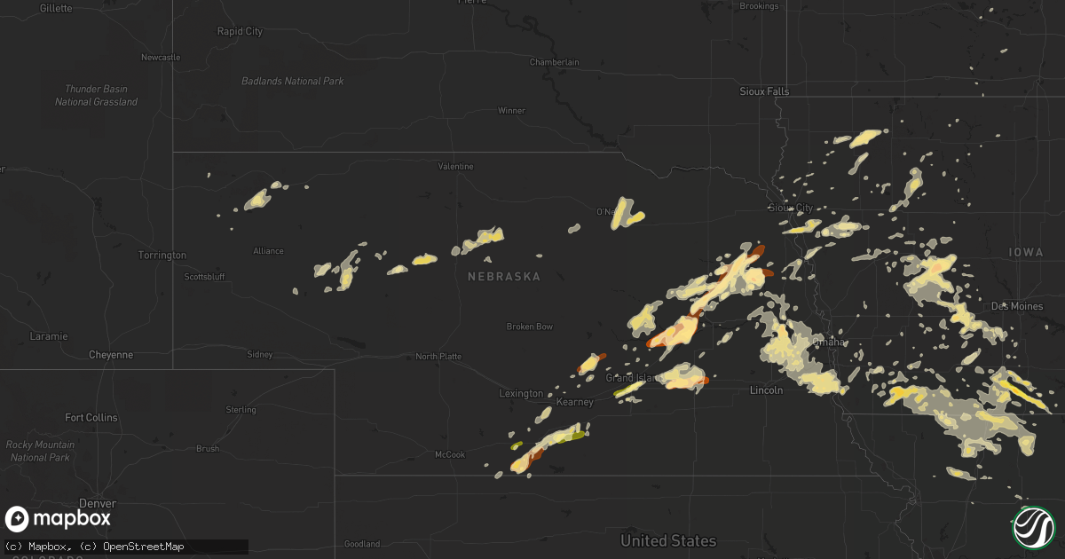
Hail Map in Nebraska on June 14, 2013
Get this storm
June 14 map
$229
one time, instant access
Download today. No call, no setup
Keep the $229
Bought the map and want the full workflow? Apply the entire $229 to a subscription within 7 days. None of it is wasted.
Every map, not just this one
This buys you this map. Subscription and you get every map we run, in the markets you choose from a few cities to whole states to nationwide. Plus real-time alerts the moment a storm fires.
Contact data
Name, contact info, occupancy, even credit band for addresses in the footprint. You go from where it hit to who to call.
Become the source they trust
Unlimited branding weather history reports on demand. You already have the documented answer ready for the property owner, and you are the one who showed up with it.
Property data and RoofTrace estimates
Pull up any address you have got, its value and the exact code rules for that jurisdiction, straight from One Click Code. Then RoofTrace estimates the squares, pitch, and roof value, priced the way you price.
Storm reports in Nebraska
Nebraska
| Date | Description |
|---|---|
| 06/14/20136:56 PM CDT | Golf ball size hail feel a couple of different times through the evening. |
| 06/14/20136:50 PM CDT | Trees down with damage to homes and power lines down. |
| 06/14/20136:41 PM CDT | A local report indicates 1.00 inch wind near HUMPHREY |
| 06/14/20136:25 PM CDT | Public report relayed by nws employee. |
| 06/14/20136:17 PM CDT | A local report indicates 60 MPH wind near AURORA AIRPORT |
| 06/14/20136:15 PM CDT | Quarter size hail reported by nance county law enforcement near plum creek bridge. |
| 06/14/20136:14 PM CDT | A local report indicates 1.00 inch wind near MONROE |
| 06/14/20136:00 PM CDT | Public report relayed by nws employee. |
| 06/14/20135:06 PM CDT | Soft quarter sized hail. |
| 06/14/20135:03 PM CDT | Started at 0458 and ongoing quarter sized hail. |
| 06/14/20134:34 PM CDT | Quarter sized hail covers the ground. Heavy rain and winds estimated at 30 mph. Hail still ongoing. |
| 06/14/20133:40 PM CDT | 5 to 10 minutes of pea to quarter sized hail starting at 340 pm. 0.30 inch of rain and still raining lightly. |
| 06/14/20132:50 AM CDT | Tree limbs were reported down. The person reporting said it was extensive. |
| 06/13/20138:30 PM CDT | A local report indicates 60 MPH wind near 7 SSE UEHLING |
| 06/13/20138:30 PM CDT | A local report indicates 60 MPH wind near 7 S UEHLING |
| 06/13/20138:28 PM CDT | A local report indicates 60 MPH wind near 1 WSW NICKERSON |
| 06/13/20138:21 PM CDT | Large trees down |
| 06/13/20138:20 PM CDT | A local report indicates 1.75 inch wind near 2 S FREMONT |
| 06/13/20138:20 PM CDT | A local report indicates 1.00 inch wind near 1 N VALLEY |
| 06/13/20137:58 PM CDT | A local report indicates 1.75 inch wind near 2 S FREMONT |
| 06/13/20137:58 PM CDT | A local report indicates 63 MPH wind near ALBION |
| 06/13/20137:50 PM CDT | Trees down with damage to homes and power lines down. |
| 06/13/20137:35 PM CDT | Power outages and trees down. |
| 06/13/20137:30 PM CDT | A local report indicates 1.50 inch wind near 4 SW PILGER |
| 06/13/20137:20 PM CDT | Trained spotter reports 58 mph wind gust and 8 to 10 inch limbs down. Winds due to outflow from nearby storms. |
| 06/13/20137:00 PM CDT | A local report indicates 1.50 inch wind near 12 S STANTON |
All States Impacted by Hail Map on June 14, 2013
Cities Impacted by Hail Map on June 14, 2013
- Wesley, IA
- Whitman, NE
- Mullen, NE
- Grand Island, NE
- Doniphan, NE
- Alda, NE
- Phillips, NE
- Wood River, NE
- Westside, IA
- Manning, IA
- Pleasanton, NE
- Hazard, NE
- Rockville, NE
- Ravenna, NE
- Thedford, NE
- Hemingford, NE
- Carroll, IA
- Glidden, IA
- Glenwood, IA
- Tabor, IA
- Malvern, IA
- Elm Creek, NE
- Loomis, NE
- Bertrand, NE
- Holdrege, NE
- Coon Rapids, IA
- Scranton, IA
- Jefferson, IA
- Silver Creek, NE
- Archer, IA
- Hospers, IA
- Sheldon, IA
- Hartley, IA
- Primghar, IA
- Atkinson, NE
- Stuart, NE
- Salix, IA
- Kellerton, IA
- Ashby, NE
- Fremont, NE
- Ashland, NE
- Waterloo, NE
- Gretna, NE
- Onawa, IA
- Stanton, NE
- Pilger, NE
- Monroe, NE
- Wisner, NE
- Leigh, NE
- Clarkson, NE
- Creston, NE
- Platte Center, NE
- Humphrey, NE
- Oberlin, KS
- Yutan, NE
- Mead, NE
- Colon, NE
- Corydon, IA
- Cedar Rapids, NE
- Belgrade, NE
- Wolbach, NE
- Fenton, IA
- Lone Rock, IA
- Orchard, NE
- Page, NE
- David City, NE
- Bellwood, NE
- Saint Paul, NE
- Encino, NM
- Iowa, LA
- Humeston, IA
- Everly, IA
- Allerton, IA
- Van Wert, IA
- Weldon, IA
- Garden Grove, IA
- Bradshaw, NE
- Henderson, NE
- Hampton, NE
- York, NE
- Las Cruces, NM
- Fort White, FL
- West Point, NE
- Dodge, NE
- Beemer, NE
- Howells, NE
- Oxford, NE
- Fonda, IA
- Albert City, IA
- Pocahontas, IA
- Manley, NE
- Avoca, NE
- Thurman, IA
- Nehawka, NE
- Union, NE
- Murdock, NE
- Plattsmouth, NE
- Weeping Water, NE
- Louisville, NE
- Murray, NE
- Elmwood, NE
- Omaha, NE
- Audubon, IA
- Panora, IA
- Yale, IA
- Dedham, IA
- Bagley, IA
- Guthrie Center, IA
- Bayard, IA
- Ralston, IA
- Hyannis, NE
- Ithaca, NE
- Dexter, IA
- Beresford, SD
- Vermillion, SD
- Shenandoah, IA
- Essex, IA
- Afton, IA
- Lorimor, IA
- Winterset, IA
- Saint Charles, IA
- Fullerton, NE
- Madison, NE
- Exline, IA
- Kirksville, MO
- Worthington, MO
- Unionville, MO
- Moulton, IA
- Glenwood, MO
- Livonia, MO
- Queen City, MO
- Greentop, MO
- Novinger, MO
- Varina, IA
- Sac City, IA
- Early, IA
- Newell, IA
- Laurens, IA
- Nemaha, IA
- Havelock, IA
- Weatherby, MO
- Maysville, MO
- Pattonsburg, MO
- King City, MO
- McFall, MO
- Murray, IA
- Thayer, IA
- Lu Verne, IA
- Lenox, IA
- Corning, IA
- Prescott, IA
- Blockton, IA
- Bonham, TX
- Indianola, IA
- Prole, IA
- Trumbull, NE
- Palmer, NE
- Seneca, NE
- Council Bluffs, IA
- Crescent, IA
- Underwood, IA
- Colby, KS
- Greenfield, IA
- Fontanelle, IA
- Ponemah, MN
- Los Alamos, NM
- Espanola, NM
- West Des Moines, IA
- Clive, IA
- Urbandale, IA
- Scribner, NE
- Newman Grove, NE
- Lindsay, NE
- Mount Ayr, IA
- Stuart, IA
- Columbus, NE
- Clarks, NE
- Central City, NE
- Genoa, NE
- Creston, IA
- Johnstown, NE
- Ainsworth, NE
- Elsmere, NE
- Starke, FL
- Corona, NM
- Grant City, MO
- Hatfield, MO
- Wellsburg, IA
- Earlham, IA
- Sloan, IA
- Homer, NE
- Winnebago, NE
- Nickerson, NE
- Diagonal, IA
- Shannon City, IA
- Jacksonville, FL
- Orange Park, FL
- Blue Earth, MN
- Ewing, NE
- Oneill, NE
- Inman, NE
- Correctionville, IA
- Cushing, IA
- Walnut, IA
- Oshkosh, NE
- Bingham, NE
- Ribera, NM
- San Jose, NM
- Pecos, NM
- Casey, IA
- Trenton, FL
- Bloomfield, IA
- Worth, MO
- Denver, MO
- Orr, MN
- Sheridan, MO
- Redding, IA
- Bedford, IA
- Sioux City, IA
- South Sioux City, NE
- Effie, MN
- Embarrass, MN
- Virginia, MN
- Britt, MN
- Tower, MN
- Brooker, FL
- Green Cove Springs, FL
- Fleming Island, FL
- Saint Johns, FL
- Saint Augustine, FL
- Danbury, IA
- Battle Creek, IA
- Leon, IA
- Grand River, IA
- Decatur, IA
- Valley, NE
- Novelty, MO
- Jameson, MO
- Aurora, NE
- Wahoo, NE
- Weston, NE
- Ceresco, NE
- Chadron, NE
- Marsland, NE
- Blythedale, MO
- Lamoni, IA
- Princeton, MO
- Eagleville, MO
- Cainsville, MO
- Macclenny, FL
- Merrill, IA
- Le Mars, IA
- Newberry, FL
- Elk Point, SD
- Templeton, IA
- Lake Charles, LA
- Beaver City, NE
- Stamford, NE
- Hampton, FL
- Orient, IA
- Brashear, MO
- Hurdland, MO
- La Plata, MO
- Gibbs, MO
- Remsen, IA
- Granville, IA
- Alton, IA
- Pleasantville, IA
- Davis City, IA
- Ridgeway, MO
- Mercer, MO
- Lufkin, TX
- Saint Libory, NE
- Middleburg, FL
- Bethany, MO
- Martinsville, MO
- New Hampton, MO
- Gilman City, MO
- Albany, MO
- Adel, IA
- Crawford, NE
- Gainesville, FL
- Albion, NE
- Pender, NE
- Promise City, IA
- Paullina, IA
- Sutherland, IA
- Calumet, IA
- Larrabee, IA
- Menlo, IA
- Osceola, NE
- Stromsburg, NE
- Arapahoe, NE
- Archer, NE
- Osceola, IA
- Hay Springs, NE
- Winnebago, MN
- Clarinda, IA
- Coin, IA
- Gravity, IA
- New Market, IA
- Nodaway, IA
- Yorktown, IA
- Anthon, IA
- Neillsville, WI
- Laramie, WY
- Cheyenne, WY
- Cairo, NE
- Vail, IA
- Denison, IA
- Villisca, IA
- New Virginia, IA
- Bronson, IA
- Moville, IA
- Climbing Hill, IA
- Hornick, IA
- Waco, NE
- Polk, NE
- Benedict, NE
- Marquette, NE
- Schaller, IA
- Fort Dodge, IA
- Silver City, IA
- Minden, NE
- Maurice, IA
- Ottosen, IA
- Bancroft, NE
- Redfield, IA
- Wirt, MN
- Carrizozo, NM
- Axtell, NE
- Stanton, IA
- Red Oak, IA
- Snyder, NE
- Cook, MN
- Greenwood, NE
- Malmo, NE
- Elkhorn, NE
- Memphis, NE
- Gibbon, NE
- Wilcox, NE
- Atlantic, IA
- Chauvin, LA
- Montegut, LA
- Pleasanton, TX
- Lineville, IA
- Mallard, IA
- Chillicothe, MO
- Norton, KS
- Wilsonville, NE
- Noonan, ND
- Danbury, WI
- Webster, WI
- Anita, IA
- Wiota, IA
- Angora, MN
- Oto, IA
- Clare, IA
- Amherst, NE
- Jordan, MT
- Circle, MT
- Woodburn, IA
- Socorro, NM
- Dakota City, NE
- Tekamah, NE
- Little Sioux, IA
- Blencoe, IA
- Humboldt, IA
- Norcatur, KS
- Fort Lauderdale, FL
- Jourdanton, TX
- Seymour, IA
- Norfolk, NE
- Hildreth, NE
- Hendley, NE
- Bell, FL
- Chiefland, FL
- South Bend, NE
- Springfield, NE
- Cedar Bluffs, NE
- Ames, NE
- Burbank, SD
- Jasper, TX
- Emerson, IA
- Griswold, IA
- Churdan, IA
- Breda, IA
- Purdum, NE
- Atlanta, MO
- Hinton, IA
- Welsh, LA
- Chapman, NE
- Perry, IA
- Rippey, IA
- Jamaica, IA
- Wakefield, NE
- Drakesville, IA
- Curlew, IA
- Arlington, NE
- North Bend, NE
- Green Castle, MO
- Orleans, NE
- Atlanta, NE
- Alma, NE
- Charter Oak, IA
- Dow City, IA
- Benton, IA
- Clearfield, IA
- Ladonia, TX
- Deloit, IA
- Craig, NE
- Oakland, NE
- Decatur, NE
- Lyons, NE
- Ida Grove, IA
- Washta, IA
- Quimby, IA
- Holstein, IA
- Chisholm, MN
- Northome, MN
- Smithland, IA
- Spickard, MO
- Trenton, MO
- Galt, MO
- Westfield, IA
- Farnhamville, IA
- Lohrville, IA
- Lake View, IA
- Union Star, MO
- Dawn, MO
- Linden, IA
- Zavalla, TX
- Sergeant Bluff, IA
- Exira, IA
- Percival, IA
- Kirbyville, TX
- Newton, TX
- Wolf Point, MT
- Mankato, MN
- Lake Butler, FL
- Waldo, FL
- Raiford, FL
- Keosauqua, IA
- Selden, KS
- Truth Or Consequences, NM
- Britt, IA
- Cameron, MO
- Deridder, LA
- Singer, LA
- Merryville, LA
- Macksburg, IA
- Kingsley, IA
- Taylor, NE
- Rushville, NE
- Utica, NE
- Lake City, IA
- Lanesboro, IA
- Rexford, KS
- Emden, MO
- Bethel, MO
- Philadelphia, MO
- Alta, IA
- Bonaparte, IA
- Shelby, IA
- Portsmouth, IA
- Jennings, LA
- Bryceville, FL
- Alcester, SD
- Morse Bluff, NE
- Lisco, NE
- Meriden, IA
- Rodney, IA
- Castana, IA
- Mapleton, IA
- Aurelia, IA
- Gallatin, MO
- Akron, IA
- Houma, LA
- Cincinnati, IA
- Centerville, IA
- Winslow, NE
- Hooper, NE
- Erath, LA
- New Iberia, LA
- Hastings, FL
- Storm Lake, IA
- Minburn, IA
- Carbon, IA
- Sanborn, IA
- Kaufman, TX
- Cherokee, IA
- Cleghorn, IA
- Brayton, IA
- Patterson, IA
- Norwalk, IA
- Bevington, IA
- Truro, IA
- Peru, IA
- Van Meter, IA
- Halbur, IA
- Adair, IA
- Saint Marys, IA
- Arcadia, IA
- Hamlin, IA
- Dawson, IA
- Newark, MO
- Somers, IA
- Gowrie, IA
- Callender, IA
- Saint Edward, NE
- Wayne, NE
- Kinder, LA
- Grand Junction, IA
- Gallina, NM
- Gentry, MO
- Sharpsburg, IA
- Ellston, IA
- Elmore, MN
- Treynor, IA
- Rising City, NE
- Lawtey, FL
- Gilmore City, IA
- Bradgate, IA
- Milford, IA
- Terril, IA
- Whiting, IA
- Le Sueur, MN
- Le Center, MN
- Cumberland, IA
- Hastings, NE
- Las Vegas, NM
- Montezuma, NM
- Spencer, IA
- Imogene, IA
- Southbury, CT
- Woodbury, CT
- Thurston, NE
- Kearney, NE
- Riverdale, NE
- Unionville, IA
- Persia, IA
- Minden, IA
- Dulac, LA
- Bridgewater, IA
- Rolfe, IA
- Hastings, IA
- Henderson, IA
- Macedonia, IA
- Manilla, IA
- Webb, IA
- Almena, KS
- Branford, FL
- Old Town, FL
- Wall Lake, IA
- Odebolt, IA
- Edison, NE
- Tingley, IA
- Ponca, NE
- Jackson, NE
- Ragley, LA
- Saint Peter, MN
- Kasota, MN
- Bennington, NE
- Cedar Creek, NE
- Boys Town, NE
- Washington, NE
- Otoe, NE
- Kennard, NE
- Waverly, NE
- Sidney, IA
- Valparaiso, NE
- Papillion, NE
- Rogers, NE
- Alvo, NE
- Woodville, TX
- Bon Wier, TX
- Minnesota Lake, MN
- Mapleton, MN
- Waldorf, MN
- Boelus, NE


