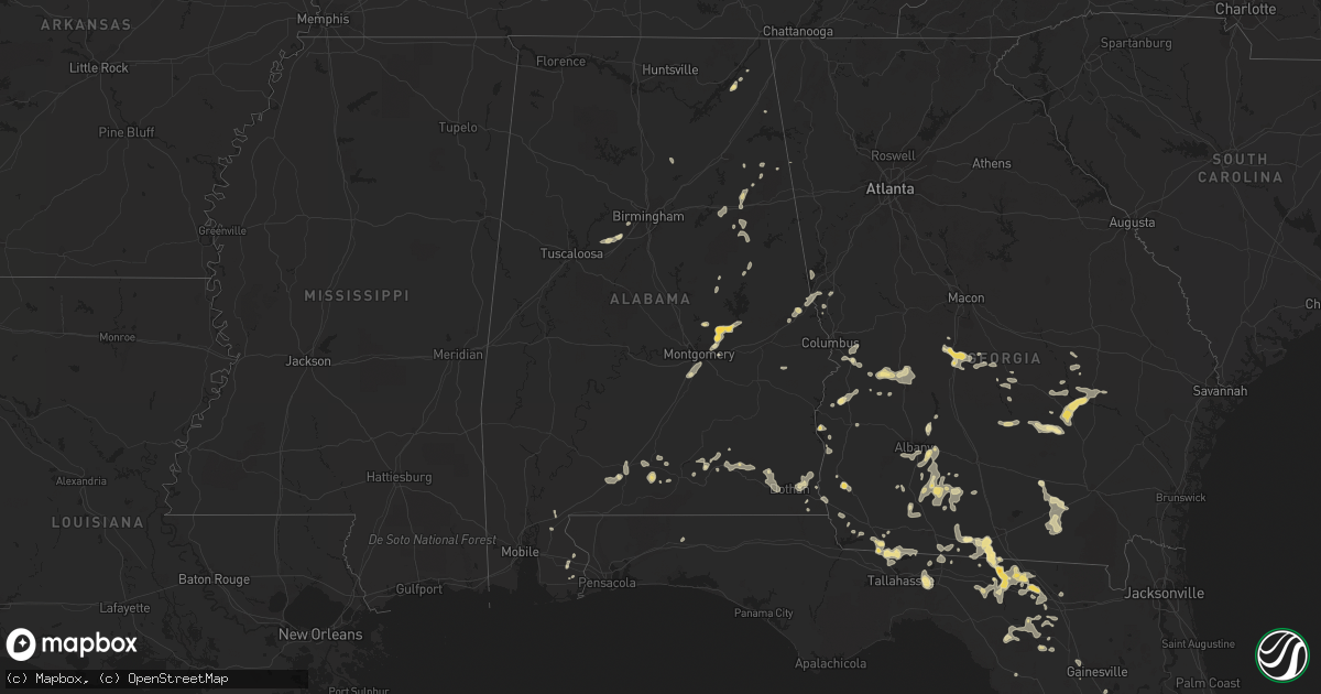
Hail Map in Alabama on June 14, 2012
Get this storm
June 14 map
$229
one time, instant access
Download today. No call, no setup
Keep the $229
Bought the map and want the full workflow? Apply the entire $229 to a subscription within 7 days. None of it is wasted.
Every map, not just this one
This buys you this map. Subscription and you get every map we run, in the markets you choose from a few cities to whole states to nationwide. Plus real-time alerts the moment a storm fires.
Contact data
Name, contact info, occupancy, even credit band for addresses in the footprint. You go from where it hit to who to call.
Become the source they trust
Unlimited branding weather history reports on demand. You already have the documented answer ready for the property owner, and you are the one who showed up with it.
Property data and RoofTrace estimates
Pull up any address you have got, its value and the exact code rules for that jurisdiction, straight from One Click Code. Then RoofTrace estimates the squares, pitch, and roof value, priced the way you price.
Storm reports in Alabama
Alabama
| Date | Description |
|---|---|
| 06/14/20126:42 PM CDT | The evergreen middleton field asos recorded a 59 mph wind gust at 642 pm cdt. |
| 06/14/20126:02 PM CDT | Multiple trees down in the claud and fleahop communities. |
| 06/14/20126:00 PM CDT | A tree down on a house with minor damage to the roof. Powerlines also reported down in the blue ridge community. Corrected for location. |
| 06/14/20126:00 PM CDT | A tree was blown onto a house. |
| 06/14/20126:00 PM CDT | Near haynes road and highway 14. |
| 06/14/20124:55 PM CDT | Trees and power lines down in and around enterprise. |
| 06/14/20124:45 PM CDT | *** 1 inj *** thunderstorm wind gusts tore the roof off a temporary structure at bama jam...injuring one person. |
| 06/14/20124:42 PM CDT | Spotter measured wind gust on a hand held anemometer one mile east of the bama jam facilities on hwy 51. |
| 06/14/20124:15 PM CDT | A couple reports of trees limbs down...blown into power lines in ozark. |
| 06/14/20124:05 PM CDT | One tree blown down in the pinckard area. |
| 06/14/20124:05 PM CDT | Dispatch in houston county reports multiple calls related to tree damage...downed power lines...and power outages in the northern part of houston county and in the doth |
| 06/14/20123:50 PM CDT | Dime to quarter size hail fell for several minutes. |
| 06/14/20123:50 PM CDT | Trees down on wallace buie road. Reported by dothan eagle. |
| 06/14/20123:50 PM CDT | Trees downed on jimbo road. Reported by dothan eagle. |
| 06/14/20123:47 PM CDT | Trees and power lines blown down in northern houston county. |
| 06/14/20123:33 PM CDT | One tree reported down on water tank lane. |
| 06/14/20123:08 PM CDT | A local report indicates 1.00 inch wind near SAKS |
| 06/14/20121:05 PM CDT | One tree down across fords valley road near hokes bluff. Time estimated from radar. |
| 06/14/201212:55 PM CDT | One tree down at the intersection of posey rd and nora drive. Also one tree down along croft ferry rd northeast of hokes bluff. Winds estimated around 40 mph from radar |
| 06/14/20122:36 AM CDT | 40-45 mph sustained for 10 minutes |
| 06/13/20128:25 PM CDT | 40-45 mph sustained for 10 minutes |
| 06/13/20127:55 PM CDT | Reported along pleasant view rd in the north johns community. One tree was also reported down in the same area. |
All States Impacted by Hail Map on June 14, 2012
Cities Impacted by Hail Map on June 14, 2012
- Mapleton, MN
- Winnebago, MN
- Dodge, NE
- Snyder, NE
- Scribner, NE
- Braithwaite, LA
- Harvey, LA
- Belle Chasse, LA
- Port Sulphur, LA
- Earth, TX
- Muleshoe, TX
- Sudan, TX
- Mayo, FL
- Turkey, TX
- Lubbock, TX
- Shallowater, TX
- Albany, GA
- Cannon Falls, MN
- Dennison, MN
- Cimarron, KS
- Dighton, KS
- Floydada, TX
- Indianola, NE
- River Falls, WI
- Hastings, MN
- Kilkenny, MN
- Lakeland, FL
- Port Saint Lucie, FL
- Oakley, KS
- Grinnell, KS
- Grenville, NM
- Vernon, TX
- Davidson, OK
- Oklaunion, TX
- Harrold, TX
- Wolfforth, TX
- Ropesville, TX
- Wilson, TX
- Tahoka, TX
- Daingerfield, TX
- Pittsburg, TX
- Pecos, TX
- Minneapolis, MN
- Concordia, KS
- Fort Gaines, GA
- Fort Stockton, TX
- Hartsfield, GA
- Doerun, GA
- Claremore, OK
- Ailey, GA
- Guymon, OK
- Goodwell, OK
- Courtland, MN
- New Ulm, MN
- Nicollet, MN
- Lafayette, MN
- Fredericksburg, IA
- Ionia, IA
- Hereford, TX
- Saint Cloud, FL
- Grandfield, OK
- Spur, TX
- Mount Hermon, LA
- Orleans, NE
- Levelland, TX
- Brownfield, TX
- Meadow, TX
- Hope Hull, AL
- Ludell, KS
- Herndon, KS
- Atwood, KS
- Harriman, TN
- Wilsonville, NE
- Buena Vista, GA
- Americus, GA
- Ellaville, GA
- Monticello, FL
- Longwood, FL
- Lake Mary, FL
- Eustis, FL
- Sorrento, FL
- Apopka, FL
- Sanford, FL
- Walthill, NE
- Rosalie, NE
- Bladen, NE
- Denton, GA
- Hazlehurst, GA
- Broxton, GA
- Balko, OK
- Live Oak, FL
- Comstock, WI
- Amery, WI
- Balsam Lake, WI
- Turtle Lake, WI
- Belleville, KS
- Ayr, NE
- Claremont, MN
- West Concord, MN
- Dodge Center, MN
- Waco, NE
- Gibbon, NE
- Utica, KS
- Quinter, KS
- Fort Supply, OK
- Fargo, OK
- Wells, MN
- Minnesota Lake, MN
- Lockney, TX
- Flomot, TX
- Townsend, TN
- Seward, NE
- Milford, NE
- Monument, KS
- Hollis, OK
- Gould, OK
- Sedan, KS
- Elk City, KS
- Post, TX
- Pine Island, MN
- Kenyon, MN
- Wanamingo, MN
- Wildorado, TX
- Amarillo, TX
- Lorenzo, TX
- Ralls, TX
- Petersburg, TX
- Wetumpka, AL
- Tallassee, AL
- Eclectic, AL
- Hill City, KS
- Moultrie, GA
- Roseland, NE
- Riverton, NE
- Campbell, NE
- Upland, NE
- Holstein, NE
- Bloomington, NE
- Franklin, NE
- Minden, NE
- Republican City, NE
- Naponee, NE
- Tolar, TX
- Goldsmith, TX
- Chiefland, FL
- Morriston, FL
- Dallas, WI
- Chetek, WI
- Barron, WI
- Cameron, WI
- Beaver Crossing, NE
- Friend, NE
- Lakeview, TX
- Dike, TX
- Sulphur Springs, TX
- Beeler, KS
- Ness City, KS
- Cologne, MN
- Norwood Young America, MN
- Young America, MN
- Waconia, MN
- Grandview, TN
- Logan, KS
- Kingfisher, OK
- Loyal, OK
- Onawa, IA
- Geneva, NE
- Strang, NE
- Mcloud, OK
- Bazine, KS
- Dimmitt, TX
- Eastaboga, AL
- Talladega, AL
- Lincoln, AL
- Lincoln, NE
- Martell, NE
- Hallam, NE
- Roca, NE
- Crosbyton, TX
- Moorefield, NE
- Stockville, NE
- Curtis, NE
- Andrews, TX
- Marathon, TX
- Ridgeland, WI
- New Auburn, WI
- Pierson, IA
- Hinton, IA
- Lawton, IA
- Kingsley, IA
- Moville, IA
- David City, NE
- Rice Lake, WI
- Choctaw, OK
- Alamo, GA
- Glenwood, GA
- Lumber City, GA
- Seminole, TX
- Cuba, KS
- Haddam, KS
- Narka, KS
- Elk Falls, KS
- Ashland, KS
- Arcadia, OK
- Guthrie, OK
- Meridian, OK
- Luther, OK
- Iowa Park, TX
- Saint Paul, MN
- Lake Elmo, MN
- Blue Hill, NE
- Webster, WI
- Oakland, NE
- Earling, IA
- Panama, IA
- Elkhorn, NE
- Gretna, NE
- Omaha, NE
- Stratton, CO
- Terril, IA
- Ellis, KS
- Plainville, KS
- Palco, KS
- Dolliver, IA
- Dickens, TX
- Vega, TX
- Lyons, NE
- Bancroft, NE
- Riley, KS
- Okeechobee, FL
- Lorida, FL
- Saronville, NE
- Clay Center, NE
- Harvard, NE
- Sharon Springs, KS
- Homerville, GA
- Morland, KS
- Quitman, GA
- Rising City, NE
- Maywood, NE
- Wilcox, NE
- Hildreth, NE
- Olsburg, KS
- Winona, KS
- Ramah, CO
- Russell, KS
- Oklahoma City, OK
- Bronson, TX
- San Augustine, TX
- Norman Park, GA
- Albert City, IA
- Rembrandt, IA
- Marathon, IA
- Storm Lake, IA
- Everly, IA
- Estherville, IA
- Fairmont, MN
- Spencer, IA
- Wallingford, IA
- Milford, IA
- Armstrong, IA
- Dickens, IA
- Swea City, IA
- Royal, IA
- Fostoria, IA
- Shelby, IA
- Portsmouth, IA
- Avoca, IA
- Harlan, IA
- Vonore, TN
- Como, TX
- Mankato, KS
- Beloit, KS
- Glen Elder, KS
- Independence, KS
- Fenton, IA
- Ringsted, IA
- Webb, IA
- Truesdale, IA
- Gibbon, MN
- Fairview, OK
- Hammon, OK
- Morgan City, LA
- Pierre Part, LA
- Jeanerette, LA
- Hugo, CO
- Genoa, CO
- Hendley, NE
- Attapulgus, GA
- Grove City, MN
- Litchfield, MN
- Cusseta, AL
- Opelika, AL
- Evergreen, AL
- Slidell, LA
- Great Bend, KS
- Olmitz, KS
- Albert, KS
- Beatrice, NE
- Filley, NE
- Pickrell, NE
- Phillipsburg, KS
- Ocklawaha, FL
- Faribault, MN
- Nerstrand, MN
- Dundas, MN
- Lonsdale, MN
- Le Center, MN
- Webster, MN
- Montgomery, MN
- Northfield, MN
- Funston, GA
- Cumberland, WI
- Nickerson, NE
- Craig, NE
- Hooper, NE
- Herman, NE
- Missouri Valley, IA
- Arlington, NE
- Winslow, NE
- Magnolia, IA
- Mondamin, IA
- Tekamah, NE
- Fremont, NE
- Logan, IA
- Pisgah, IA
- Jensen Beach, FL
- Birchwood, WI
- Mikana, WI
- Marcus, IA
- Paullina, IA
- Meriden, IA
- Larrabee, IA
- Cleghorn, IA
- Cherokee, IA
- Hale Center, TX
- Plainview, TX
- Matador, TX
- Arlington, MN
- Leonardville, KS
- Green, KS
- Elberta, AL
- Frederic, WI
- Hooker, OK
- Knox City, TX
- Munday, TX
- Seymour, TX
- Pearson, GA
- Channing, TX
- Dumas, TX
- Webber, KS
- Courtland, KS
- Formoso, KS
- Bogue, KS
- Lenora, KS
- Beaver City, NE
- Oxford, NE
- Stamford, NE
- Hartley, TX
- Dalhart, TX
- Walland, TN
- Sevierville, TN
- Dresser, WI
- Osceola, WI
- Hector, MN
- Randolph, KS
- Barnes, KS
- Hunter, KS
- Garden City, KS
- Lamar, CO
- Preston, GA
- Wallace, KS
- Montgomery, AL
- Crossville, TN
- Spring City, TN
- Holyoke, MN
- Mangum, OK
- Madison, FL
- Lee, FL
- Pinetta, FL
- Pickton, TX
- Saltillo, TX
- Nelson, NE
- Woodward, OK
- Portis, KS
- Osborne, KS
- Rush, CO
- Meade, KS
- Plains, KS
- Christmas, FL
- Orlando, FL
- Texhoma, OK
- Stratford, TX
- Shamrock, TX
- Wellington, TX
- Buffalo Lake, MN
- Piedmont, KS
- Harrah, OK
- Wellston, OK
- Clifton, KS
- Hastings, NE
- Glenvil, NE
- Tecumseh, OK
- Shawnee, OK
- Sutton, NE
- Hardy, NE
- Ruskin, NE
- Justiceburg, TX
- Cottonwood, AL
- Gordon, AL
- Abernathy, TX
- Idalou, TX
- Vero Beach, FL
- Blair, NE
- Bennington, NE
- Washington, NE
- Kennard, NE
- Waterloo, NE
- Yutan, NE
- Hawkinsville, GA
- Perry, GA
- Elko, GA
- Zumbrota, MN
- Buffalo, OK
- Lebanon, NE
- Norcatur, KS
- Danbury, NE
- Gaylord, MN
- Mansfield, LA
- Golden Meadow, LA
- Paducah, TX
- Norton, KS
- Mooreland, OK
- Cleo Springs, OK
- Waynoka, OK
- Ringwood, OK
- Isabella, OK
- Ellsworth, KS
- Wilson, KS
- Rozel, KS
- Larned, KS
- Argyle, GA
- Opp, AL
- Deweese, NE
- Fairfield, NE
- Edgar, NE
- Cherokee, OK
- Burlington, OK
- Electra, TX
- Elba, AL
- Oberlin, KS
- McCook, NE
- Shickley, NE
- Carleton, NE
- Curlew, IA
- Olton, TX
- Jasper, FL
- Jennings, FL
- Milltown, WI
- Shell Lake, WI
- Exeland, WI
- Haugen, WI
- Luck, WI
- Sarona, WI
- Barronett, WI
- Saint Croix Falls, WI
- Stone Lake, WI
- Ellendale, MN
- Claude, TX
- Lawrence, NE
- Exeter, NE
- York, NE
- McCool Junction, NE
- Cortland, NE
- Louisville, TN
- Knoxville, TN
- Alcoa, TN
- Rockford, TN
- Lamar, OK
- West Monroe, LA
- Wetumka, OK
- Okemah, OK
- Glencoe, MN
- Fairmont, NE
- Ellinwood, KS
- Kellyton, AL
- Rockford, AL
- Bainbridge, GA
- Cowarts, AL
- Ashford, AL
- Webb, AL
- Snyder, TX
- Girard, TX
- Anthon, IA
- Oto, IA
- Climbing Hill, IA
- Bronson, IA
- Hornick, IA
- Salix, IA
- Glasco, KS
- Guide Rock, NE
- Honey Creek, IA
- Bowling Green, FL
- Wann, OK
- Copan, OK
- Le Sueur, MN
- Hennessey, OK
- Quail, TX
- Graysville, TN
- Hubbell, NE
- Hebron, NE
- Hays, KS
- Victoria, KS
- Walker, KS
- Saint James, LA
- Sioux Rapids, IA
- Burlington, CO
- Mapleton, IA
- Rodney, IA
- Cushing, IA
- Danbury, IA
- Battle Creek, IA
- Correctionville, IA
- Smithland, IA
- Sloan, IA
- Sergeant Bluff, IA
- Sioux City, IA
- Holstein, IA
- Tobias, NE
- Homestead, FL
- Miami, FL
- Cusseta, GA
- Lake Wales, FL
- Oliver Springs, TN
- Oak Ridge, TN
- Hoxie, KS
- Park, KS
- Many, LA
- Nekoma, KS
- Stewart, MN
- Jewell, KS
- Norway, KS
- Jamestown, KS
- Republic, KS
- Agenda, KS
- Minneapolis, KS
- Scandia, KS
- Clyde, KS
- Simpson, KS
- Delphos, KS
- Barnard, KS
- Morrowville, KS
- Mahaska, KS
- Dixie, GA
- Belle Plaine, MN
- Plato, MN
- Henderson, MN
- Green Isle, MN
- Deshler, NE
- Davenport, NE
- Belvidere, NE
- Bruning, NE
- Goodhue, MN
- Randolph, MN
- Paisley, FL
- Winter Springs, FL
- Clarendon, TX
- Superior, NE
- Windom, MN
- Murdock, NE
- Paden, OK
- Prague, OK
- Eastman, GA
- Brantley, AL
- Kim, CO
- Valdosta, GA
- Chaska, MN
- Victoria, MN
- Prior Lake, MN
- Morristown, MN
- Waseca, MN
- Richland, GA
- Hartland, MN
- New Richland, MN
- Georgetown, GA
- Almena, KS
- Stockton, KS
- Laverne, OK
- Ames, OK
- Drummond, OK
- Aspermont, TX
- Old Glory, TX
- Weston, NE
- Unadilla, GA
- Delavan, MN
- Easton, MN
- Pisgah, AL
- Jacksonville, AL
- Anniston, AL
- Deer Trail, CO
- Hanston, KS
- Kingston, TN
- Eden Valley, MN
- Watkins, MN
- Saint Cloud, MN
- Cold Spring, MN
- Kimball, MN
- Paynesville, MN
- Richmond, MN
- Rockville, MN
- Prairie View, KS
- Laurens, IA
- Alta, IA
- Dwight, NE
- Brainard, NE
- Hampton, MN
- Lincoln, KS
- Willow, OK
- Kermit, TX
- Linn, KS
- Edmond, OK
- Chester, OK
- Cedar Vale, KS
- Grenola, KS
- McAlpin, FL
- Branford, FL
- O'Brien, FL
- Wellborn, FL
- Otis, KS
- Manhattan, KS
- Holcomb, KS
- Sutherland, IA
- Raymond, NE
- Davey, NE
- Ceresco, NE
- Waverly, NE
- Avoca, NE
- Palmyra, NE
- Elmwood, NE
- Unadilla, NE
- Wood River, NE
- Doniphan, NE
- Alda, NE
- Pikeville, TN
- Burr Oak, KS
- Agate, CO
- Limon, CO
- Meeker, OK
- Vinson, OK
- Yukon, OK
- Red Cloud, NE
- Hoisington, KS
- Rock, KS
- Winfield, KS
- Udall, KS
- Milam, TX
- Lake City, MN
- Remsen, IA
- Ulysses, KS
- Climax, GA
- Hedley, TX
- Lakeville, MN
- Matheson, CO
- Somerset, WI
- Marine On Saint Croix, MN
- Bell, FL
- Claflin, KS
- Bunker Hill, KS
- Dorrance, KS
- Altoona, FL
- Vona, CO
- Selden, KS
- Fort Rucker, AL
- Newton, AL
- Midland City, AL
- Ozark, AL
- Piedmont, AL
- Rhine, GA
- Fitzgerald, GA
- Clewiston, FL
- Winthrop, MN
- Red Wing, MN
- Cleburne, TX
- Esbon, KS
- Kanopolis, KS
- Columbia, AL
- Wakeeney, KS
- Collyer, KS
- Owatonna, MN
- Ransom, KS
- Kingman, KS
- Roxie, MS
- Dozier, AL
- Leesburg, GA
- Oakfield, GA
- Culbertson, NE
- Farnam, NE
- Blakely, GA
- Tallahassee, FL
- Moore Haven, FL
- Fargo, GA
- Brookwood, AL
- Vance, AL
- Ulysses, NE
- Surprise, NE
- Malcolm, NE
- Staplehurst, NE
- Utica, NE
- Valparaiso, NE
- Malmo, NE
- Bruno, NE
- Shelby, NE
- Bee, NE
- Gresham, NE
- Prague, NE
- Garland, NE
- Wahoo, NE
- Dorchester, NE
- Greenwood, NE
- Pleasant Dale, NE
- Tribune, KS
- Wellington, AL
- Morris, GA
- Hialeah, FL
- Pierceville, KS
- Ingalls, KS
- Calhoun, LA
- Eros, LA
- Bessemer, AL
- McCalla, AL
- Tarrytown, GA
- Mount Vernon, GA
- Vidalia, GA
- Coolidge, GA
- Niotaze, KS
- Peru, KS
- Carlton, MN
- Wrenshall, MN
- Barnum, MN
- Moose Lake, MN
- Kerrick, MN
- Central City, NE
- Pfeifer, KS
- Weskan, KS
- Afton, MN
- Crete, NE
- Olivia, MN
- Oak, NE
- Havana, FL
- Whiting, IA
- Decatur, NE
- Sale Creek, TN
- Dayton, TN
- Colquitt, GA
- Earlsboro, OK
- Oviedo, FL
- Alden, MN
- Neola, IA
- Alma, NE
- Hugoton, KS
- Jack, AL
- Saint Peter, MN
- New Prague, MN
- Byron, NE
- Holyrood, KS
- Kettle River, MN
- Lineville, AL
- Ashland, AL
- Red Level, AL
- Andalusia, AL
- Chalmette, LA
- Follett, TX
- Pelham, GA
- Bristow, OK
- Maud, OK
- Wewoka, OK
- Seminole, OK
- Holdenville, OK
- Bowlegs, OK
- Oneonta, AL
- Cleveland, AL
- Plains, GA
- Lyons, KS
- Geneseo, KS
- Soperton, GA
- Sale City, GA
- Sylvester, GA
- Meigs, GA
- Camilla, GA
- Pavo, GA
- Independence, LA
- Hammond, LA
- Tickfaw, LA
- Lamesa, TX
- Monroe, LA
- Springfield, NE
- Primghar, IA
- Winnebago, NE
- Pender, NE
- Thurston, NE
- Kensington, KS
- Lumpkin, GA
- Juniata, NE
- Mazeppa, MN
- Oronoco, MN
- Protection, KS
- Hamburg, MN
- Blue Rapids, KS
- Cassoday, KS
- El Dorado, KS
- Crestview, FL
- Douglass, KS
- Dutton, AL
- Winnsboro, LA
- Medford, MN
- Fort Calhoun, NE
- Kinsley, KS
- Carmen, OK
- Weatherford, TX
- Lipan, TX
- Milligan, NE
- Ohiowa, NE
- Hollister, OK
- Frederick, OK
- Havana, KS
- Longton, KS
- Baconton, GA
- Denham Springs, LA
- New Brockton, AL
- Uvalda, GA
- Cedar Bluffs, NE
- Morse Bluff, NE
- Burdett, KS
- Oglethorpe, GA
- Andersonville, GA
- Mankato, MN
- Valley Center, KS
- Lyons, GA
- Pampa, TX
- Groom, TX
- Choudrant, LA
- Bennet, NE
- Ledyard, IA
- Headland, AL
- Cokato, MN
- Gaylord, KS
- Atwood, OK
- Lake City, FL
- Palmer, KS
- Morganville, KS
- Marshallville, GA
- Garber, OK
- Hunter, OK
- Enid, OK
- Winnfield, LA
- Atlanta, LA
- Ceylon, MN
- Granada, MN
- Peterson, IA
- Bancroft, IA
- Blue Earth, MN
- Cylinder, IA
- Graettinger, IA
- Linn Grove, IA
- Dunnell, MN
- Hartley, IA
- Calumet, IA
- Cochran, GA
- Arriba, CO
- Rochester, MN
- Plant City, FL
- Section, AL
- Atwater, MN
- Perryton, TX
- Pleasant Grove, AL
- Granbury, TX
- Monahans, TX
- Houma, LA
- Schriever, LA
- Granada, CO
- Coffeyville, KS
- Napoleonville, LA
- Shattuck, OK
- Kabetogama, MN
- Excelsior, MN
- Minnetonka, MN
- Chanhassen, MN
- Wayzata, MN
- Eden Prairie, MN
- Pine Mountain, GA
- Moscow, KS
- Quincy, FL
- Meadville, MS
- Robertsdale, AL
- Stillwater, MN
- Cordova, NE
- Hutchinson, MN
- Hanover, KS
- Aurora, KS
- Zumbro Falls, MN
- Haven, KS
- Mount Hope, KS
- Weleetka, OK
- Duke, OK
- Eagle, NE
- Syracuse, NE
- Weeping Water, NE
- Clayton, KS
- Jennings, KS
- Atlanta, KS
- Crab Orchard, TN
- Rockwood, TN
- Clatonia, NE
- Andale, KS
- Rush Center, KS
- Castleberry, AL
- Washington, KS
- Fort Benning, GA
- Heartwell, NE
- Kenesaw, NE
- Clare, IA
- Gilmore City, IA
- Allen, KS
- Scott City, KS
- Union Springs, AL
- Hurtsboro, AL
- Theriot, LA
- Hordville, NE
- Clarks, NE
- Clay Center, KS
- Saint George, KS
- Burden, KS
- Maryville, TN
- Kountze, TX
- Burrton, KS
- Sedgwick, KS
- Dunnellon, FL
- South Haven, MN
- Waite Park, MN
- Fairfax, MN
- Reynolds, NE
- Randlett, OK
- Rochester, TX
- Boutte, LA
- Enterprise, AL
- Gorham, KS
- Cleveland, OK
- Fort Valley, GA
- Montezuma, GA
- Bay Minette, AL
- Woodston, KS
- Meno, OK
- Wichita Falls, TX
- Dothan, AL
- Hopkins, MN
- West Point, NE
- Ashland, NE
- Fowler, KS
- Bethany, OK
- Piedmont, OK
- Lane, OK
- Stringtown, OK
- Zephyrhills, FL
- Long Island, KS
- Weinert, TX
- Clayton, LA
- Cairo, GA
- Sparks, OK
- Allen, OK
- Fairbury, NE
- Munford, AL
- Cashion, OK
- Okarche, OK
- Childress, TX
- Westmoreland, KS
- Rogers, NE
- North Bend, NE
- Fall River, KS
- Lorraine, KS
- Sumner, GA
- Vidor, TX
- Colby, KS
- McCracken, KS
- La Crosse, KS
- Spivey, KS
- Locust Grove, OK
- Sterling, NE
- Burchard, NE
- Steinauer, NE
- Byers, CO
- Opa Locka, FL
- Hamilton, GA
- Grainfield, KS
- Du Pont, GA
- Leon, KS
- Augusta, KS
- Alexander City, AL
- Letohatchee, AL
- Boston, GA
- Manilla, IA
- Manning, IA
- Morton, TX
- Coushatta, LA
- Wakita, OK
- Nash, OK
- Kellyville, OK
- Donalsonville, GA
- Brinson, GA
- Aurora, NE
- Inland, NE
- Dodson, TX
- Cuthbert, GA
- Nowata, OK
- Superior, WI
- Plattsmouth, NE
- Murray, NE
- St John, KS
- West Point, GA
- Gainesville, FL
- Alachua, FL
- Frankfort, KS
- Sundown, TX
- Sapulpa, OK
- Thomasville, GA
- Cleveland, TN
- Olustee, OK
- Stockholm, WI
- Randall, KS
- Madison Lake, MN
- Cleveland, MN
- Kasota, MN
- Yantis, TX
- Natoma, KS
- Holliday, TX
- Adger, AL
- Crescent, OK
- Talala, OK
- Crowell, TX
- Howard Lake, MN
- Winsted, MN
- Byron, MN
- Woodbine, IA
- Boys Town, NE
- Uehling, NE
- Valley, NE
- Ames, NE
- Blencoe, IA
- Modale, IA
- Little Sioux, IA
- Vermillion, MN
- Prescott, WI
- Aurelia, IA
- Phillips, NE
- Helena, OK
- Brownton, MN
- New Auburn, MN
- Hudson, WI
- Shakopee, MN
- Houlton, WI
- Bayport, MN
- Cosmos, MN
- Ayrshire, IA
- Ruthven, IA
- Silver Creek, NE
- Genoa, NE
- Chester, NE
- Trumbull, NE
- Denton, NE
- Goehner, NE
- Inavale, NE
- Toronto, KS
- Gridley, KS
- Yates Center, KS
- Madisonville, TN
- Jordan, MN
- Clayton, WI
- Fort Pierce, FL
- Stuart, FL
- Heron Lake, MN
- Fulda, MN
- Cragford, AL
- Bruce, WI
- Waterville, KS
- Council Bluffs, IA
- Crescent, IA
- McClelland, IA
- Underwood, IA
- Howells, NE
- Lagrange, GA
- Shreveport, LA
- Trego, WI
- Spooner, WI
- Iron City, GA
- Lloyd, FL
- Papillion, NE
- Louisville, NE
- Trenton, NE
- Cedartown, GA
- Pike Road, AL
- Ocoee, FL
- Longdale, OK
- Dassel, MN
- Healy, KS
- Bird Island, MN
- Farmington, MN
- Lester Prairie, MN
- Elko New Market, MN
- Darwin, MN
- Welch, MN
- Carver, MN
- Silver Lake, MN
- Otoe, NE
- Dunbar, NE
- Emporia, KS
- Treynor, IA
- Delaware, OK
- Repton, AL
- Range, AL
- Brewton, AL
- McKenzie, AL
- Warwick, GA
- Cordele, GA
- Okeene, OK
- Mutual, OK
- Galliano, LA
- Danbury, WI
- Kearney, NE
- Rayville, LA
- Columbia, LA
- Archer, FL
- Alexander, KS
- Waldorf, MN
- Damar, KS
- Bartley, NE
- Jakin, GA
- Mangham, LA
- Coalgate, OK
- Stuart, OK
- Catharine, KS
- Robeline, LA
- Fort Payne, AL
- Tecumseh, NE
- Kit Carson, CO
- Gramercy, LA
- Memphis, TX
- Amboy, MN
- Loveland, OK
- Seiling, OK
- Kiowa, OK
- La Place, LA
- Chandler, OK
- Hawthorne, FL
- Micanopy, FL
- Western, NE
- Steele City, NE
- Hollenberg, KS
- Endicott, NE
- Onaga, KS
- Wardville, OK
- Arapahoe, NE
- Holbrook, NE
- Chireno, TX
- Valley, AL
- Lanett, AL
- Waldo, KS
- Fort White, FL
- Cut Off, LA
- Cross City, FL
- New Richmond, WI
- White Springs, FL
- Sturgeon Lake, MN
- Foxboro, WI
- Westphalia, IA
- Darrouzett, TX
- Booker, TX
- Giltner, NE
- Crab Orchard, NE
- Miami, TX
- Day, FL
- Greenville, FL
- Barwick, GA
- Saint Joseph, MN
- Silver Springs, FL
- Sleepy Eye, MN
- Orange, TX
- Buna, TX
- Caney, KS
- Tyro, KS
- Canyon, TX
- Ochlocknee, GA
- Weaver, AL
- Oxford, AL
- Altamonte Springs, FL
- Casselberry, FL
- Sandstone, MN
- Dustin, OK
- Calvin, OK
- Smith Center, KS
- Athol, KS
- Rule, TX
- Adams, NE
- Walton, NE
- Aline, OK
- Nehawka, NE
- Alvo, NE
- Newalla, OK
- Jones, OK
- Cambridge, KS
- Medford, OK
- Wray, GA
- Agra, KS
- Manson, IA


