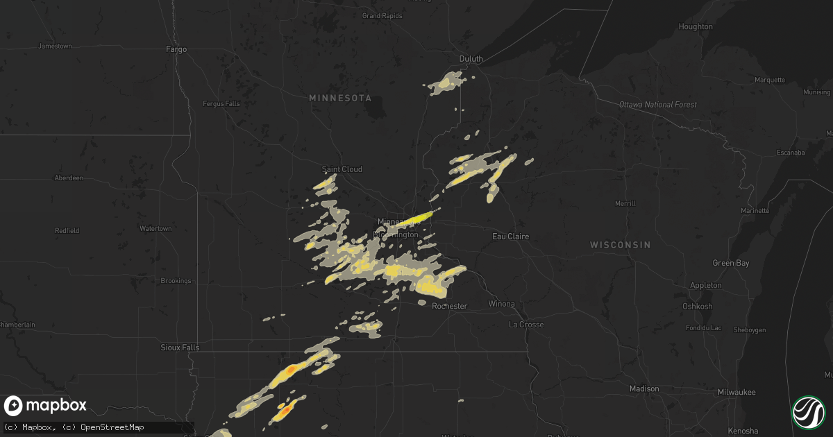
Hail Map on June 14, 2012
Get this storm
June 14 map
$229
one time, instant access
Download today. No call, no setup
Keep the $229
Bought the map and want the full workflow? Apply the entire $229 to a subscription within 7 days. None of it is wasted.
Every map, not just this one
This buys you this map. Subscription and you get every map we run, in the markets you choose from a few cities to whole states to nationwide. Plus real-time alerts the moment a storm fires.
Contact data
Name, contact info, occupancy, even credit band for addresses in the footprint. You go from where it hit to who to call.
Become the source they trust
Unlimited branding weather history reports on demand. You already have the documented answer ready for the property owner, and you are the one who showed up with it.
Property data and RoofTrace estimates
Pull up any address you have got, its value and the exact code rules for that jurisdiction, straight from One Click Code. Then RoofTrace estimates the squares, pitch, and roof value, priced the way you price.
States Impacted by Hail Map on June 14, 2012
Storm reports
Colorado
| Date | Description |
|---|---|
| 06/14/20126:51 PM CDT | A local report indicates 1.00 inch wind near 5 N LAMAR |
| 06/14/20125:03 PM CDT | A local report indicates a tornado near 14 NE TWO BUTTES |
| 06/14/20123:37 PM CDT | Brief landspout touched down in open field for less than 1 minute. |
| 06/13/201211:46 PM CDT | A local report indicates 1.00 inch wind near 9 NNE GENOA |
| 06/13/201211:15 PM CDT | A local report indicates 1.00 inch wind near 8 SE GENOA |
| 06/13/201210:48 PM CDT | A local report indicates 1.75 inch wind near HUGO |
| 06/13/201210:47 PM CDT | A local report indicates 1.50 inch wind near HUGO |
| 06/13/201210:39 PM CDT | Broken windshields |
Tennessee
| Date | Description |
|---|---|
| 06/14/20126:10 PM CDT | A couple of trees down on grandview mountain. |
| 06/14/20126:05 PM CDT | Utility company reported several trees and power lines down in the oakdale area. |
| 06/14/20125:46 PM CDT | A local report indicates 1.75 inch wind near 2 NE WEARS VALLEY |
| 06/14/20125:10 PM CDT | Utility company reported power lines down due to a fallen tree off of carrs creek road. |
| 06/14/20125:06 PM CDT | One tree down. |
| 06/14/20122:55 PM CDT | Utility company reported a couple trees down on power lines on sweetwater vonore road. |
| 06/14/20122:55 PM CDT | Utility company reported a tree down on power lines on northfork road. |
| 06/13/20127:40 PM CDT | Numerous trees down. Numerous reports of damage. Roads blocked. |
| 06/13/20127:36 PM CDT | Two trees down. |
| 06/13/20127:35 PM CDT | Utility company reported several locations with power lines knocked down by large tree limbs and trees including highway 127 and upper east valley road. |
Louisiana
| Date | Description |
|---|---|
| 06/14/20124:40 PM CDT | Tree down across interstate 20 at calhoun. |
| 06/14/20123:45 PM CDT | Report of wind damage at holly park off toledo bend lake. |
| 06/14/20122:27 PM CDT | Newspaper reports downed trees and power lines in marrero and harvey due to thunderstorm winds |
| 06/14/20122:26 PM CDT | Knbg pkwnd 18054/1926. |
| 06/14/20122:21 PM CDT | Knbg pkwnd 20054/1921. |
Oklahoma
| Date | Description |
|---|---|
| 06/14/20121:07 AM CDT | A local report indicates 70 MPH wind near BRAMAN |
| 06/14/201212:35 AM CDT | Woodring awos |
| 06/13/201211:00 PM CDT | A local report indicates 58 MPH wind near 3 SSW FREEDOM |
| 06/13/201210:45 PM CDT | A local report indicates 60 MPH wind near 16 NNE FREEDOM |
| 06/13/201210:40 PM CDT | Ok mesonet |
| 06/13/201210:10 PM CDT | A local report indicates 1.00 inch wind near 3 SE SLAPOUT |
| 06/13/201210:10 PM CDT | Nickel to quarter hail. E50mph gust. |
| 06/13/20129:59 PM CDT | A local report indicates 1.00 inch wind near 14 NE ELMWOOD |
| 06/13/20129:46 PM CDT | A local report indicates 1.00 inch wind near 4 SSE ELMWOOD |
| 06/13/20129:35 PM CDT | A local report indicates 61 MPH wind near 1 SSW BEAVER |
| 06/13/20129:15 PM CDT | A local report indicates 61 MPH wind near 1 SSW BEAVER |
| 06/13/20129:10 PM CDT | A local report indicates 69 MPH wind near 1 SSW BEAVER |
| 06/13/20129:08 PM CDT | With dime size hail...heavy rain...leading to near zero visibility |
| 06/13/20128:44 PM CDT | From 7 miles south of the kansas and oklahoma state line along hollow north 115 and then 1 mile east along hollow east 0070. |
| 06/13/20128:15 PM CDT | A local report indicates 1.50 inch wind near 6 N GUYMON |
| 06/13/20128:15 PM CDT | A local report indicates 1.75 inch wind near 12 N TEXHOMA |
| 06/13/20127:56 PM CDT | A local report indicates 1.75 inch wind near 1 W GUYMON |
| 06/13/20127:55 PM CDT | A local report indicates 1.25 inch wind near 5 N GUYMON |
| 06/13/20127:54 PM CDT | A local report indicates 1.00 inch wind near 1 W GUYMON |
| 06/13/20127:52 PM CDT | A local report indicates 1.00 inch wind near 2 N GUYMON |
| 06/13/20127:45 PM CDT | 2 foot diameter tree was broken about 2 to 3 feet above the ground. Estimated 70 mph wind gust. |
Florida
| Date | Description |
|---|---|
| 06/14/20125:50 PM CDT | Two trees down and three small tree limbs down near red hill road in walton county. Time approximated. |
| 06/14/20125:25 PM CDT | Trees down on power lines along highway 2 near darlington. Delayed report. Time approximate. |
| 06/14/20125:05 PM CDT | Trees blown into power lines. |
| 06/14/20124:45 PM CDT | Half of a pine tree snapped off. |
| 06/14/20124:30 PM CDT | Large tree limbs blown down. Largest was about a foot in diameter and 20 feet long. |
| 06/14/20124:25 PM CDT | Two trees blown down just in washington county from the washington-jackson county line in the gilberts mill area. |
| 06/14/20124:15 PM CDT | Public reported quarter size hail at us 92 and wiggins rd. |
| 06/14/20124:15 PM CDT | Several trees and power lines down at us 92 and wiggins rd. |
| 06/14/20122:45 PM CDT | The public reported small tree limbs down in the fort white area. The limbs were less than 2 inches in diameter. |
| 06/14/20122:14 PM CDT | Douglaston townhome and villas. Tree down on roof with damage from storm that just passed through area. |
| 06/14/20122:10 PM CDT | 2 trees were reported down on a house and car on east washington street in orlando. Time estimated from radar. |
| 06/14/20122:00 PM CDT | 1/4 mile s of city hall. Balcony on apartment complex damaged by trees. Other trees down. |
| 06/14/20121:50 PM CDT | A tree fell on a house on east maine avenue in longwood. Time estimated from radar. |
| 06/14/20121:47 PM CDT | Two trees were knocked down in longwood off of orlando avenue producing property damage. Time estimated from radar. |
| 06/14/20121:45 PM CDT | A large tree was reported downed in altamonte springs on baybreeze lane. Time estimated from radar. |
| 06/14/20121:43 PM CDT | Corrected from previous report - outdoor furniture and debris blown around with estimated winds 50-60 mph. |
| 06/14/20121:40 PM CDT | A large tree fell on a house on loch lomond avenue in longwood. Time estimated from radar. |
| 06/14/20121:40 PM CDT | A large tree fell on a house on cheetah trail in apopka. Time estimated from radar. |
| 06/14/20121:40 PM CDT | A large tree was knocked down on stoney ridge drive in longwood. Time estimated from radar. |
| 06/14/20121:38 PM CDT | Storm chaser with davis/vantage pro |
| 06/14/201212:20 PM CDT | 4 trees felled by downburst in havana. |
Wisconsin
| Date | Description |
|---|---|
| 06/14/20128:00 AM CDT | A local report indicates 1.00 inch wind near RICE LAKE |
| 06/13/20128:30 PM CDT | Few trees blown down |
Minnesota
| Date | Description |
|---|---|
| 06/14/20126:18 PM CDT | Delayed report machine shop roof damage..several large trees down |
| 06/14/20124:58 PM CDT | Mostly nickels with a few quarters...time estimated from radar |
| 06/14/20124:51 PM CDT | Hail lasted a couple minutes than got smaller as storm headed toward lake city |
| 06/14/20124:49 PM CDT | A local report indicates 1.25 inch wind near 3 WNW OAK CENTER |
| 06/14/20124:47 PM CDT | A local report indicates 1.25 inch wind near 1 WSW BELLECHESTER |
| 06/14/20124:03 PM CDT | 10 to 12 inch trees down at 9th and water street |
| 06/14/20123:15 PM CDT | 40 foot maple snapped. |
| 06/14/20122:29 PM CDT | Power lines down near intersection of midway rd and us highway 2. Lines down on highway 2. |
| 06/14/20122:25 PM CDT | A local report indicates 1.00 inch wind near HOLYOKE |
| 06/14/201212:47 PM CDT | Beach street |
| 06/14/201212:42 PM CDT | A local report indicates 1.00 inch wind near MAPLEWOOD |
| 06/14/201212:37 PM CDT | A local report indicates 1.00 inch wind near 1 SSW HENDERSON |
| 06/14/201212:35 PM CDT | Highway 694 and 36 |
| 06/14/201212:33 PM CDT | 35e and maryland |
| 06/14/201212:32 PM CDT | A local report indicates 1.00 inch wind near MINNEAPOLIS |
| 06/14/201212:31 PM CDT | Rice and highway 36 |
| 06/14/201212:30 PM CDT | A local report indicates 1.00 inch wind near 2 S LAUDERDALE |
| 06/14/201212:30 PM CDT | Reported at intersection of 694 and mn hwy 120. |
| 06/14/201212:29 PM CDT | A local report indicates 1.00 inch wind near MINNEAPOLIS |
| 06/14/201212:29 PM CDT | Reported 2 miles south of calhoun beach |
| 06/14/201212:29 PM CDT | A local report indicates 1.00 inch wind near FALCON HEIGHTS |
| 06/14/201212:22 PM CDT | Reported in uptown |
| 06/14/201212:20 PM CDT | A local report indicates 1.00 inch wind near MAPLEWOOD |
| 06/13/20128:15 PM CDT | Law enforcement reported large tree down blocking the road...time estimated from radar |
| 06/13/20128:05 PM CDT | Branches down in town and between elgin and plainview |
| 06/13/20128:00 PM CDT | Large branches down in town |
| 06/13/20127:47 PM CDT | Emergency management reports power outages in the city of rochester |
| 06/13/20127:41 PM CDT | At kttc studios northwest side of rochester |
| 06/13/20127:30 PM CDT | Emergency management reported trees down in the city of genoa |
| 06/13/20127:22 PM CDT | Semi blown over between dodge center and kasson on highway 14 |
| 06/13/20127:20 PM CDT | Half of a tree blown down one foot in diameter |
| 06/13/20127:20 PM CDT | Trained spotters reported lots of trees down and a rotating wall cloud near the city of wasioja |
| 06/13/20127:12 PM CDT | Numerous large trees downed in along county highway 1... Along with a hay wagon blown into the road. |
| 06/13/20127:10 PM CDT | A local report indicates 1.25 inch wind near 6 SW WANAMINGO |
| 06/13/20127:00 PM CDT | Multiple reports of wind damage...including trees snapped off...barns and livestock damaged and injured and power lines down from kenyon to wanamingo and zumbrota. |
Kansas
| Date | Description |
|---|---|
| 06/14/20126:55 PM CDT | A local report indicates 58 MPH wind near HILL CITY |
| 06/14/20126:54 PM CDT | Estimated 40 to 50 mph winds |
| 06/14/20126:50 PM CDT | A local report indicates 1.00 inch wind near N GARDEN CITY |
| 06/14/20126:50 PM CDT | Six to seven powerlines were blown down. Numerous tree limbs reported blown down around town. |
| 06/14/20126:48 PM CDT | A local report indicates 62 MPH wind near PHILLIPSBURG AIRPORT |
| 06/14/20126:45 PM CDT | The report was from near ness city. |
| 06/14/20126:35 PM CDT | A local report indicates 1.00 inch wind near 11 NW NESS CITY |
| 06/14/20126:30 PM CDT | A local report indicates 1.75 inch wind near 19 SE NORTON |
| 06/14/20126:26 PM CDT | A local report indicates 60 MPH wind near 2 WSW CALVERT |
| 06/14/20126:15 PM CDT | A local report indicates 60 MPH wind near 9 NNE BIG BOW |
| 06/14/20126:10 PM CDT | Parts of roofing ripped off building. Two branches over 4 inches in diameter branches blown down onto road. |
| 06/14/20126:03 PM CDT | A local report indicates 59 MPH wind near 1 ENE JOHNSON CITY |
| 06/14/20126:00 PM CDT | A local report indicates 1.00 inch wind near NORTON |
| 06/14/20125:58 PM CDT | Large tree down. Tree limbs 3 to 4 inch in diameter broken off. Nickel sized hail. |
| 06/14/20125:50 PM CDT | Rolled over camper at airport...estimated 60 mph winds. Numerous trees down in norton and numerous power outages. |
| 06/14/20125:50 PM CDT | A local report indicates 1.00 inch wind near 4 W NORTON |
| 06/14/20125:50 PM CDT | Estimated gusts up to 70 mph. |
| 06/14/20124:55 PM CDT | Dime size hail still falling. |
| 06/14/20124:30 PM CDT | Hail still falling. Ground white with pea to golf ball size hail. |
| 06/14/20124:30 PM CDT | Estimated location of report. |
| 06/14/20122:45 AM CDT | Tree downed. |
| 06/14/20122:20 AM CDT | A local report indicates 60 MPH wind near SEDAN |
| 06/14/20121:04 AM CDT | Large tree limbs downed near highway 81 and highway 166 intersection. |
| 06/14/201212:46 AM CDT | A local report indicates 60 MPH wind near WELLINGTON AIRPORT |
| 06/14/201212:38 AM CDT | A local report indicates 62 MPH wind near WELLINGTON AIRPORT |
| 06/14/201212:29 AM CDT | Large tree limbs downed. |
| 06/13/201211:49 PM CDT | A local report indicates 63 MPH wind near 4 E MATFIELD GREEN |
| 06/13/201210:16 PM CDT | A local report indicates 62 MPH wind near 2 SW ABILENE |
| 06/13/201210:10 PM CDT | Time estimated |
| 06/13/20129:49 PM CDT | A local report indicates 60 MPH wind near 1 SW GREENSBURG |
| 06/13/20129:38 PM CDT | A local report indicates 60 MPH wind near 6 N WELLS |
| 06/13/20129:31 PM CDT | Small branches down |
| 06/13/20128:59 PM CDT | A local report indicates 70 MPH wind near 5 N GLASCO |
| 06/13/20128:35 PM CDT | A local report indicates 60 MPH wind near 2 WNW BISON |
| 06/13/20128:34 PM CDT | A local report indicates 62 MPH wind near BELOIT AIRPORT |
| 06/13/20128:33 PM CDT | A local report indicates 1.50 inch wind near OAKLEY |
| 06/13/20128:25 PM CDT | A local report indicates 60 MPH wind near 8 N MORROWVILLE |
| 06/13/20128:24 PM CDT | Heavy rainfall and limited visibility |
| 06/13/20128:22 PM CDT | A local report indicates 1.00 inch wind near SW CATHERINE |
| 06/13/20128:20 PM CDT | Visibility was reduced to near zero in blowing dust. |
| 06/13/20128:04 PM CDT | A local report indicates 60 MPH wind near MAHASKA |
| 06/13/20128:00 PM CDT | A local report indicates 60 MPH wind near 1 WNW BAZINE |
| 06/13/20128:00 PM CDT | A local report indicates 58 MPH wind near GOVE |
| 06/13/20127:59 PM CDT | A local report indicates 61 MPH wind near 5 N ELLIS |
| 06/13/20127:50 PM CDT | A local report indicates 60 MPH wind near 2 SE WAKEENEY |
| 06/13/20127:50 PM CDT | A local report indicates 1.00 inch wind near 6 SE HOXIE |
| 06/13/20127:40 PM CDT | A local report indicates 58 MPH wind near SMITH CENTER AIRPORT |
| 06/13/20127:20 PM CDT | A local report indicates 1.00 inch wind near 9 W SCOTT STATE LAKE |
| 06/13/20127:20 PM CDT | Measured gust at rooks county airport |
| 06/13/20127:18 PM CDT | A local report indicates 1.00 inch wind near 9 W SCOTT STATE LAKE |
| 06/13/20127:18 PM CDT | A local report indicates a tornado near 4 SSW BEELER |
| 06/13/20127:15 PM CDT | Dime-sized hail. Wind gusts estimated 50 to 60 mph. |
| 06/13/20127:10 PM CDT | A local report indicates 1.00 inch wind near 3 NNE VODA |
| 06/13/20127:10 PM CDT | A local report indicates 1.00 inch wind near 5 SW DIGHTON |
| 06/13/20127:05 PM CDT | A local report indicates 70 MPH wind near HILL CITY |
| 06/13/20127:00 PM CDT | An empty truck trailor was blown over just west of garden city and 1 foot diameter tree limbs were blown down on 5th street. |
| 06/13/20127:00 PM CDT | Two semi trailer trucks were rolled. |
| 06/13/20127:00 PM CDT | A local report indicates 65 MPH wind near 2 N GARDEN CITY |
Iowa
| Date | Description |
|---|---|
| 06/14/20126:50 PM CDT | A local report indicates 1.00 inch wind near 7 SSE MOVILLE |
| 06/14/20126:30 PM CDT | A local report indicates 2.00 inch wind near MARATHON |
| 06/14/20126:30 PM CDT | A local report indicates 1.25 inch wind near 3 N MARATHON |
| 06/14/20126:28 PM CDT | A local report indicates 1.00 inch wind near 2 SE PAULLINA |
| 06/14/20126:25 PM CDT | A local report indicates 1.75 inch wind near 2 W MARATHON |
| 06/14/20126:22 PM CDT | A local report indicates 1.75 inch wind near 6 SE SIOUX RAPIDS |
| 06/14/20126:15 PM CDT | A local report indicates 1.00 inch wind near 4 NE TRUESDALE |
| 06/13/20127:47 PM CDT | A local report indicates 61 MPH wind near ESTHERVILLE AIRPORT |
| 06/13/20127:37 PM CDT | A local report indicates 1.50 inch wind near 2 S ESTHERVILLE |
| 06/13/20127:33 PM CDT | Updated report. Some trees uprooted and powerlines down. Earlier damage to the house was only a broken window. |
| 06/13/20127:30 PM CDT | A local report indicates 1.75 inch wind near 1 E TERRIL |
| 06/13/20127:29 PM CDT | Mostly pea size hail with a few nickel to quarter size hailstones. |
| 06/13/20127:25 PM CDT | Trees down |
| 06/13/20127:25 PM CDT | A local report indicates 1.00 inch wind near 2 SE TERRIL |
| 06/13/20127:25 PM CDT | Several 5-6 inch diameter limbs broken off. |
| 06/13/20127:05 PM CDT | A local report indicates 1.00 inch wind near 4 NW SPENCER |
Texas
| Date | Description |
|---|---|
| 06/14/20126:57 PM CDT | A local report indicates 1.25 inch wind near 8 SW DUMAS |
| 06/14/20126:54 PM CDT | At middlewell road and farm to market road 722 southwest of dumas. |
| 06/14/20126:45 PM CDT | A local report indicates 65 MPH wind near 1 N HALE CENTER |
| 06/14/20126:40 PM CDT | A local report indicates 1.75 inch wind near 10 E HARTLEY |
| 06/14/20126:13 PM CDT | 2 mi west of fort stockton on alpine highway |
| 06/14/20126:11 PM CDT | A local report indicates 1.00 inch wind near 3 E WILDORADO |
| 06/14/20126:06 PM CDT | Relayed by nssl |
| 06/14/20125:57 PM CDT | A local report indicates 1.75 inch wind near BELDING |
| 06/14/20125:15 PM CDT | Relayed by nssl |
| 06/14/20125:15 PM CDT | A local report indicates 1.25 inch wind near 1 E HEREFORD |
| 06/14/20125:10 PM CDT | Relayed by nssl |
| 06/14/20125:04 PM CDT | A local report indicates 1.00 inch wind near 1 E HEREFORD |
| 06/14/20124:15 PM CDT | Tree down along highway 21 southeast of san augustine. |
| 06/14/20124:00 PM CDT | Trees down along highway 21 near geneva. |
| 06/14/20123:45 PM CDT | Wind damage at holly park marina on toledo bend lake. Powerlines down nearby and leaf debris |
| 06/14/20122:10 AM CDT | Gusts from dissipating showers in excess of 60 mph from 205 am to 220 am peaking at 210 am |
| 06/14/20121:50 AM CDT | A local report indicates 62 MPH wind near 2 NW CHILDRESS |
| 06/14/20121:50 AM CDT | West texas mesonet report |
| 06/13/201210:50 PM CDT | West texas mesonet report |
| 06/13/201210:15 PM CDT | A local report indicates 75 MPH wind near 2 WSW CLARENDON |
| 06/13/20129:55 PM CDT | A local report indicates 1.00 inch wind near 1 W DARROUZETT |
| 06/13/20129:43 PM CDT | A local report indicates 1.00 inch wind near BOOKER |
| 06/13/20129:30 PM CDT | West texas mesonet report |
| 06/13/20129:20 PM CDT | A local report indicates 1.00 inch wind near 8 SW LUBBOCK |
| 06/13/20129:15 PM CDT | Near 98th st and milwaukee st |
| 06/13/20129:15 PM CDT | Golf ball hail reported |
| 06/13/20129:15 PM CDT | A local report indicates 1.00 inch wind near 6 S LUBBOCK |
| 06/13/20129:00 PM CDT | A local report indicates 60 MPH wind near 7 SSE MCLEAN |
| 06/13/20128:45 PM CDT | West texas mesonet |
| 06/13/20128:40 PM CDT | West texas mesonet report |
| 06/13/20128:13 PM CDT | A local report indicates 1.25 inch wind near ANDREWS |
| 06/13/20128:06 PM CDT | A local report indicates 1.25 inch wind near HOWARDWICK |
| 06/13/20128:05 PM CDT | West texas mesonet report |
| 06/13/20128:03 PM CDT | Tree uprooted. |
| 06/13/20127:55 PM CDT | A local report indicates 66 MPH wind near 2 WSW CLARENDON |
| 06/13/20127:55 PM CDT | West texas mesonet report |
| 06/13/20127:22 PM CDT | A local report indicates 59 MPH wind near 6 ENE AMARILLO |
| 06/13/20127:15 PM CDT | West texas mesonet report |
| 06/13/20127:05 PM CDT | West texas mesonet |
| 06/13/20127:00 PM CDT | A local report indicates 65 MPH wind near 2 NW PLAINVIEW |
Nebraska
| Date | Description |
|---|---|
| 06/14/20126:57 PM CDT | A local report indicates 60 MPH wind near OFFUTT AFB |
| 06/14/20126:55 PM CDT | There are several trees down due to thunderstorm wind gusts |
| 06/14/20126:48 PM CDT | Wind gusts estimated to be 60 mph with golf ball sized hail ongoing along with very heavy rainfall. |
| 06/14/20126:48 PM CDT | There are trees down along with power outages |
| 06/14/20126:32 PM CDT | A local report indicates 1.00 inch wind near DEWEESE |
| 06/14/20126:32 PM CDT | A local report indicates 70 MPH wind near LAWRENCE |
| 06/14/20126:30 PM CDT | A local report indicates 60 MPH wind near EDGAR |
| 06/14/20126:27 PM CDT | A local report indicates 60 MPH wind near 5 SSE OXFORD |
| 06/14/20126:19 PM CDT | A local report indicates 1.50 inch wind near 16 SW STOCKVILLE |
| 06/14/20126:14 PM CDT | Tennis ball size |
| 06/14/20126:10 PM CDT | Ping pong ball size hail and also gusts up to 60 mph along showboat road |
| 06/14/20126:08 PM CDT | At the lincoln airport. |
| 06/14/20126:07 PM CDT | Also 45 mph gusts |
| 06/14/20126:03 PM CDT | 70 mph wind gusts were also reported with this storm |
| 06/14/20126:00 PM CDT | Outflow winds estimated at 60 to 70 mph |
| 06/14/20125:57 PM CDT | 70mph wind was also reported along with the hail. |
| 06/14/20125:56 PM CDT | Hail up to quarter size in seward reported by a lancaster county spotter who was in seward. |
| 06/14/20125:53 PM CDT | Hail up to quarter size for the last 10 minutes |
| 06/14/20125:45 PM CDT | Hail up to quarter size |
| 06/14/20125:35 PM CDT | A local report indicates 1.25 inch wind near 4 E MCCOOK |
| 06/14/20125:25 PM CDT | A local report indicates 1.00 inch wind near ORLEANS |
| 06/14/20125:15 PM CDT | 1.80 of rain fell with the hail. |
| 06/14/20125:14 PM CDT | A local report indicates 1.00 inch wind near 4 S WILSONVILLE |
| 06/14/20125:10 PM CDT | Lasted for about 15 minutes 510pm-525pm. |
| 06/14/20125:04 PM CDT | Estimated 40-50 mph winds. |
| 06/14/20124:57 PM CDT | A few ping pong ball size stones |
| 06/14/20124:51 PM CDT | Golf ball sized hail with heavy rain in town. |
| 06/14/20124:48 PM CDT | A local report indicates 1.00 inch wind near WILSONVILLE |
| 06/13/20127:40 PM CDT | A local report indicates 60 MPH wind near 3 NE CHESTER |
| 06/13/20127:22 PM CDT | Hail ongoing. |
| 06/13/20127:16 PM CDT | A local report indicates 65 MPH wind near 1 W OFFUTT AFB |
| 06/13/20127:05 PM CDT | A local report indicates 1.50 inch wind near HILDRETH |
| 06/13/20127:00 PM CDT | A local report indicates 69 MPH wind near OFFUTT AFB |
| 06/13/20127:00 PM CDT | 4 inch diameter tree limbs down and power out at 84th and giles. |
Georgia
| Date | Description |
|---|---|
| 06/14/20126:40 PM CDT | Emergency manager reported ten to fifteen trees down along whitfield road. |
| 06/14/20126:10 PM CDT | The 911 center received reports of trees and powerlines down including a report of a tree landing on a mobile home. No reports of injuries at this time. |
| 06/14/20125:30 PM CDT | Toombs county emergency management relayed reports of 2-3 trees downed onto 2 houses and a car. Radar estimated time of 1830 edt. |
| 06/14/20124:22 PM CDT | Stewart county sheriffs office relayed a report of a downed tree in lumpkin. Radar estimated time of 1722 edt. |
| 06/14/20124:22 PM CDT | A county official reported a tree down on troatman road. |
| 06/14/20124:22 PM CDT | Emergency manager reported 3 trees down approximately six miles east of lumpkin. |
| 06/14/20124:22 PM CDT | County official reported a tree down on holder road. |
| 06/14/20124:15 PM CDT | Emergency manager relayed a report of quarter sized hail south of highway 30 between buena vista and preston. |
| 06/14/20124:05 PM CDT | A few trees and power lines down near highway 39 in northern clay county. |
| 06/14/20123:54 PM CDT | The draneville local store reported quarter sized hail along with water running through the aisles. |
| 06/14/20123:00 PM CDT | Trees down on river road in columbia. Reported by dothan eagle. |
| 06/14/20122:08 PM CDT | Large hail reported. |
| 06/14/20122:08 PM CDT | 2 trees felled by downburst. |
| 06/14/20121:00 PM CDT | 2 trees fellled by downburst. |
Alabama
| Date | Description |
|---|---|
| 06/14/20126:42 PM CDT | The evergreen middleton field asos recorded a 59 mph wind gust at 642 pm cdt. |
| 06/14/20126:02 PM CDT | Multiple trees down in the claud and fleahop communities. |
| 06/14/20126:00 PM CDT | A tree down on a house with minor damage to the roof. Powerlines also reported down in the blue ridge community. Corrected for location. |
| 06/14/20126:00 PM CDT | A tree was blown onto a house. |
| 06/14/20126:00 PM CDT | Near haynes road and highway 14. |
| 06/14/20124:55 PM CDT | Trees and power lines down in and around enterprise. |
| 06/14/20124:45 PM CDT | *** 1 inj *** thunderstorm wind gusts tore the roof off a temporary structure at bama jam...injuring one person. |
| 06/14/20124:42 PM CDT | Spotter measured wind gust on a hand held anemometer one mile east of the bama jam facilities on hwy 51. |
| 06/14/20124:15 PM CDT | A couple reports of trees limbs down...blown into power lines in ozark. |
| 06/14/20124:05 PM CDT | One tree blown down in the pinckard area. |
| 06/14/20124:05 PM CDT | Dispatch in houston county reports multiple calls related to tree damage...downed power lines...and power outages in the northern part of houston county and in the doth |
| 06/14/20123:50 PM CDT | Trees down on wallace buie road. Reported by dothan eagle. |
| 06/14/20123:50 PM CDT | Dime to quarter size hail fell for several minutes. |
| 06/14/20123:50 PM CDT | Trees downed on jimbo road. Reported by dothan eagle. |
| 06/14/20123:47 PM CDT | Trees and power lines blown down in northern houston county. |
| 06/14/20123:33 PM CDT | One tree reported down on water tank lane. |
| 06/14/20123:08 PM CDT | A local report indicates 1.00 inch wind near SAKS |
| 06/14/20121:05 PM CDT | One tree down across fords valley road near hokes bluff. Time estimated from radar. |
| 06/14/201212:55 PM CDT | One tree down at the intersection of posey rd and nora drive. Also one tree down along croft ferry rd northeast of hokes bluff. Winds estimated around 40 mph from radar |
| 06/14/20122:36 AM CDT | 40-45 mph sustained for 10 minutes |
| 06/13/20128:25 PM CDT | 40-45 mph sustained for 10 minutes |
| 06/13/20127:55 PM CDT | Reported along pleasant view rd in the north johns community. One tree was also reported down in the same area. |
Cities Impacted by Hail Map on June 14, 2012
- Mapleton, MN
- Winnebago, MN
- Dodge, NE
- Snyder, NE
- Scribner, NE
- Braithwaite, LA
- Harvey, LA
- Belle Chasse, LA
- Port Sulphur, LA
- Earth, TX
- Muleshoe, TX
- Sudan, TX
- Mayo, FL
- Turkey, TX
- Lubbock, TX
- Shallowater, TX
- Albany, GA
- Cannon Falls, MN
- Dennison, MN
- Cimarron, KS
- Dighton, KS
- Floydada, TX
- Indianola, NE
- River Falls, WI
- Hastings, MN
- Kilkenny, MN
- Lakeland, FL
- Port Saint Lucie, FL
- Oakley, KS
- Grinnell, KS
- Grenville, NM
- Vernon, TX
- Davidson, OK
- Oklaunion, TX
- Harrold, TX
- Wolfforth, TX
- Ropesville, TX
- Wilson, TX
- Tahoka, TX
- Daingerfield, TX
- Pittsburg, TX
- Pecos, TX
- Minneapolis, MN
- Concordia, KS
- Fort Gaines, GA
- Fort Stockton, TX
- Hartsfield, GA
- Doerun, GA
- Claremore, OK
- Ailey, GA
- Guymon, OK
- Goodwell, OK
- Courtland, MN
- New Ulm, MN
- Nicollet, MN
- Lafayette, MN
- Fredericksburg, IA
- Ionia, IA
- Hereford, TX
- Saint Cloud, FL
- Grandfield, OK
- Spur, TX
- Mount Hermon, LA
- Orleans, NE
- Levelland, TX
- Brownfield, TX
- Meadow, TX
- Hope Hull, AL
- Ludell, KS
- Herndon, KS
- Atwood, KS
- Harriman, TN
- Wilsonville, NE
- Buena Vista, GA
- Americus, GA
- Ellaville, GA
- Monticello, FL
- Longwood, FL
- Lake Mary, FL
- Eustis, FL
- Sorrento, FL
- Apopka, FL
- Sanford, FL
- Walthill, NE
- Rosalie, NE
- Bladen, NE
- Denton, GA
- Hazlehurst, GA
- Broxton, GA
- Balko, OK
- Live Oak, FL
- Comstock, WI
- Amery, WI
- Balsam Lake, WI
- Turtle Lake, WI
- Belleville, KS
- Ayr, NE
- Claremont, MN
- West Concord, MN
- Dodge Center, MN
- Waco, NE
- Gibbon, NE
- Utica, KS
- Quinter, KS
- Fort Supply, OK
- Fargo, OK
- Wells, MN
- Minnesota Lake, MN
- Lockney, TX
- Flomot, TX
- Townsend, TN
- Seward, NE
- Milford, NE
- Monument, KS
- Hollis, OK
- Gould, OK
- Sedan, KS
- Elk City, KS
- Post, TX
- Pine Island, MN
- Kenyon, MN
- Wanamingo, MN
- Wildorado, TX
- Amarillo, TX
- Lorenzo, TX
- Ralls, TX
- Petersburg, TX
- Wetumpka, AL
- Tallassee, AL
- Eclectic, AL
- Hill City, KS
- Moultrie, GA
- Roseland, NE
- Riverton, NE
- Campbell, NE
- Upland, NE
- Holstein, NE
- Bloomington, NE
- Franklin, NE
- Minden, NE
- Republican City, NE
- Naponee, NE
- Tolar, TX
- Goldsmith, TX
- Chiefland, FL
- Morriston, FL
- Dallas, WI
- Chetek, WI
- Barron, WI
- Cameron, WI
- Beaver Crossing, NE
- Friend, NE
- Lakeview, TX
- Dike, TX
- Sulphur Springs, TX
- Beeler, KS
- Ness City, KS
- Cologne, MN
- Norwood Young America, MN
- Young America, MN
- Waconia, MN
- Grandview, TN
- Logan, KS
- Kingfisher, OK
- Loyal, OK
- Onawa, IA
- Geneva, NE
- Strang, NE
- Mcloud, OK
- Bazine, KS
- Dimmitt, TX
- Eastaboga, AL
- Talladega, AL
- Lincoln, AL
- Lincoln, NE
- Martell, NE
- Hallam, NE
- Roca, NE
- Crosbyton, TX
- Moorefield, NE
- Stockville, NE
- Curtis, NE
- Andrews, TX
- Marathon, TX
- Ridgeland, WI
- New Auburn, WI
- Pierson, IA
- Hinton, IA
- Lawton, IA
- Kingsley, IA
- Moville, IA
- David City, NE
- Rice Lake, WI
- Choctaw, OK
- Alamo, GA
- Glenwood, GA
- Lumber City, GA
- Seminole, TX
- Cuba, KS
- Haddam, KS
- Narka, KS
- Elk Falls, KS
- Ashland, KS
- Arcadia, OK
- Guthrie, OK
- Meridian, OK
- Luther, OK
- Iowa Park, TX
- Saint Paul, MN
- Lake Elmo, MN
- Blue Hill, NE
- Webster, WI
- Oakland, NE
- Earling, IA
- Panama, IA
- Elkhorn, NE
- Gretna, NE
- Omaha, NE
- Stratton, CO
- Terril, IA
- Ellis, KS
- Plainville, KS
- Palco, KS
- Dolliver, IA
- Dickens, TX
- Vega, TX
- Lyons, NE
- Bancroft, NE
- Riley, KS
- Okeechobee, FL
- Lorida, FL
- Saronville, NE
- Clay Center, NE
- Harvard, NE
- Sharon Springs, KS
- Homerville, GA
- Morland, KS
- Quitman, GA
- Rising City, NE
- Maywood, NE
- Wilcox, NE
- Hildreth, NE
- Olsburg, KS
- Winona, KS
- Ramah, CO
- Russell, KS
- Oklahoma City, OK
- Bronson, TX
- San Augustine, TX
- Norman Park, GA
- Albert City, IA
- Rembrandt, IA
- Marathon, IA
- Storm Lake, IA
- Everly, IA
- Estherville, IA
- Fairmont, MN
- Spencer, IA
- Wallingford, IA
- Milford, IA
- Armstrong, IA
- Dickens, IA
- Swea City, IA
- Royal, IA
- Fostoria, IA
- Shelby, IA
- Portsmouth, IA
- Avoca, IA
- Harlan, IA
- Vonore, TN
- Como, TX
- Mankato, KS
- Beloit, KS
- Glen Elder, KS
- Independence, KS
- Fenton, IA
- Ringsted, IA
- Webb, IA
- Truesdale, IA
- Gibbon, MN
- Fairview, OK
- Hammon, OK
- Morgan City, LA
- Pierre Part, LA
- Jeanerette, LA
- Hugo, CO
- Genoa, CO
- Hendley, NE
- Attapulgus, GA
- Grove City, MN
- Litchfield, MN
- Cusseta, AL
- Opelika, AL
- Evergreen, AL
- Slidell, LA
- Great Bend, KS
- Olmitz, KS
- Albert, KS
- Beatrice, NE
- Filley, NE
- Pickrell, NE
- Phillipsburg, KS
- Ocklawaha, FL
- Faribault, MN
- Nerstrand, MN
- Dundas, MN
- Lonsdale, MN
- Le Center, MN
- Webster, MN
- Montgomery, MN
- Northfield, MN
- Funston, GA
- Cumberland, WI
- Nickerson, NE
- Craig, NE
- Hooper, NE
- Herman, NE
- Missouri Valley, IA
- Arlington, NE
- Winslow, NE
- Magnolia, IA
- Mondamin, IA
- Tekamah, NE
- Fremont, NE
- Logan, IA
- Pisgah, IA
- Jensen Beach, FL
- Birchwood, WI
- Mikana, WI
- Marcus, IA
- Paullina, IA
- Meriden, IA
- Larrabee, IA
- Cleghorn, IA
- Cherokee, IA
- Hale Center, TX
- Plainview, TX
- Matador, TX
- Arlington, MN
- Leonardville, KS
- Green, KS
- Elberta, AL
- Frederic, WI
- Hooker, OK
- Knox City, TX
- Munday, TX
- Seymour, TX
- Pearson, GA
- Channing, TX
- Dumas, TX
- Webber, KS
- Courtland, KS
- Formoso, KS
- Bogue, KS
- Lenora, KS
- Beaver City, NE
- Oxford, NE
- Stamford, NE
- Hartley, TX
- Dalhart, TX
- Walland, TN
- Sevierville, TN
- Dresser, WI
- Osceola, WI
- Hector, MN
- Randolph, KS
- Barnes, KS
- Hunter, KS
- Garden City, KS
- Lamar, CO
- Preston, GA
- Wallace, KS
- Montgomery, AL
- Crossville, TN
- Spring City, TN
- Holyoke, MN
- Mangum, OK
- Madison, FL
- Lee, FL
- Pinetta, FL
- Pickton, TX
- Saltillo, TX
- Nelson, NE
- Woodward, OK
- Portis, KS
- Osborne, KS
- Rush, CO
- Meade, KS
- Plains, KS
- Christmas, FL
- Orlando, FL
- Texhoma, OK
- Stratford, TX
- Shamrock, TX
- Wellington, TX
- Buffalo Lake, MN
- Piedmont, KS
- Harrah, OK
- Wellston, OK
- Clifton, KS
- Hastings, NE
- Glenvil, NE
- Tecumseh, OK
- Shawnee, OK
- Sutton, NE
- Hardy, NE
- Ruskin, NE
- Justiceburg, TX
- Cottonwood, AL
- Gordon, AL
- Abernathy, TX
- Idalou, TX
- Vero Beach, FL
- Blair, NE
- Bennington, NE
- Washington, NE
- Kennard, NE
- Waterloo, NE
- Yutan, NE
- Hawkinsville, GA
- Perry, GA
- Elko, GA
- Zumbrota, MN
- Buffalo, OK
- Lebanon, NE
- Norcatur, KS
- Danbury, NE
- Gaylord, MN
- Mansfield, LA
- Golden Meadow, LA
- Paducah, TX
- Norton, KS
- Mooreland, OK
- Cleo Springs, OK
- Waynoka, OK
- Ringwood, OK
- Isabella, OK
- Ellsworth, KS
- Wilson, KS
- Rozel, KS
- Larned, KS
- Argyle, GA
- Opp, AL
- Deweese, NE
- Fairfield, NE
- Edgar, NE
- Cherokee, OK
- Burlington, OK
- Electra, TX
- Elba, AL
- Oberlin, KS
- McCook, NE
- Shickley, NE
- Carleton, NE
- Curlew, IA
- Olton, TX
- Jasper, FL
- Jennings, FL
- Milltown, WI
- Shell Lake, WI
- Exeland, WI
- Haugen, WI
- Luck, WI
- Sarona, WI
- Barronett, WI
- Saint Croix Falls, WI
- Stone Lake, WI
- Ellendale, MN
- Claude, TX
- Lawrence, NE
- Exeter, NE
- York, NE
- McCool Junction, NE
- Cortland, NE
- Louisville, TN
- Knoxville, TN
- Alcoa, TN
- Rockford, TN
- Lamar, OK
- West Monroe, LA
- Wetumka, OK
- Okemah, OK
- Glencoe, MN
- Fairmont, NE
- Ellinwood, KS
- Kellyton, AL
- Rockford, AL
- Bainbridge, GA
- Cowarts, AL
- Ashford, AL
- Webb, AL
- Snyder, TX
- Girard, TX
- Anthon, IA
- Oto, IA
- Climbing Hill, IA
- Bronson, IA
- Hornick, IA
- Salix, IA
- Glasco, KS
- Guide Rock, NE
- Honey Creek, IA
- Bowling Green, FL
- Wann, OK
- Copan, OK
- Le Sueur, MN
- Hennessey, OK
- Quail, TX
- Graysville, TN
- Hubbell, NE
- Hebron, NE
- Hays, KS
- Victoria, KS
- Walker, KS
- Saint James, LA
- Sioux Rapids, IA
- Burlington, CO
- Mapleton, IA
- Rodney, IA
- Cushing, IA
- Danbury, IA
- Battle Creek, IA
- Correctionville, IA
- Smithland, IA
- Sloan, IA
- Sergeant Bluff, IA
- Sioux City, IA
- Holstein, IA
- Tobias, NE
- Homestead, FL
- Miami, FL
- Cusseta, GA
- Lake Wales, FL
- Oliver Springs, TN
- Oak Ridge, TN
- Hoxie, KS
- Park, KS
- Many, LA
- Nekoma, KS
- Stewart, MN
- Jewell, KS
- Norway, KS
- Jamestown, KS
- Republic, KS
- Agenda, KS
- Minneapolis, KS
- Scandia, KS
- Clyde, KS
- Simpson, KS
- Delphos, KS
- Barnard, KS
- Morrowville, KS
- Mahaska, KS
- Dixie, GA
- Belle Plaine, MN
- Plato, MN
- Henderson, MN
- Green Isle, MN
- Deshler, NE
- Davenport, NE
- Belvidere, NE
- Bruning, NE
- Goodhue, MN
- Randolph, MN
- Paisley, FL
- Winter Springs, FL
- Clarendon, TX
- Superior, NE
- Windom, MN
- Murdock, NE
- Paden, OK
- Prague, OK
- Eastman, GA
- Brantley, AL
- Kim, CO
- Valdosta, GA
- Chaska, MN
- Victoria, MN
- Prior Lake, MN
- Morristown, MN
- Waseca, MN
- Richland, GA
- Hartland, MN
- New Richland, MN
- Georgetown, GA
- Almena, KS
- Stockton, KS
- Laverne, OK
- Ames, OK
- Drummond, OK
- Aspermont, TX
- Old Glory, TX
- Weston, NE
- Unadilla, GA
- Delavan, MN
- Easton, MN
- Pisgah, AL
- Jacksonville, AL
- Anniston, AL
- Deer Trail, CO
- Hanston, KS
- Kingston, TN
- Eden Valley, MN
- Watkins, MN
- Saint Cloud, MN
- Cold Spring, MN
- Kimball, MN
- Paynesville, MN
- Richmond, MN
- Rockville, MN
- Prairie View, KS
- Laurens, IA
- Alta, IA
- Dwight, NE
- Brainard, NE
- Hampton, MN
- Lincoln, KS
- Willow, OK
- Kermit, TX
- Linn, KS
- Edmond, OK
- Chester, OK
- Cedar Vale, KS
- Grenola, KS
- McAlpin, FL
- Branford, FL
- O'Brien, FL
- Wellborn, FL
- Otis, KS
- Manhattan, KS
- Holcomb, KS
- Sutherland, IA
- Raymond, NE
- Davey, NE
- Ceresco, NE
- Waverly, NE
- Avoca, NE
- Palmyra, NE
- Elmwood, NE
- Unadilla, NE
- Wood River, NE
- Doniphan, NE
- Alda, NE
- Pikeville, TN
- Burr Oak, KS
- Agate, CO
- Limon, CO
- Meeker, OK
- Vinson, OK
- Yukon, OK
- Red Cloud, NE
- Hoisington, KS
- Rock, KS
- Winfield, KS
- Udall, KS
- Milam, TX
- Lake City, MN
- Remsen, IA
- Ulysses, KS
- Climax, GA
- Hedley, TX
- Lakeville, MN
- Matheson, CO
- Somerset, WI
- Marine On Saint Croix, MN
- Bell, FL
- Claflin, KS
- Bunker Hill, KS
- Dorrance, KS
- Altoona, FL
- Vona, CO
- Selden, KS
- Fort Rucker, AL
- Newton, AL
- Midland City, AL
- Ozark, AL
- Piedmont, AL
- Rhine, GA
- Fitzgerald, GA
- Clewiston, FL
- Winthrop, MN
- Red Wing, MN
- Cleburne, TX
- Esbon, KS
- Kanopolis, KS
- Columbia, AL
- Wakeeney, KS
- Collyer, KS
- Owatonna, MN
- Ransom, KS
- Kingman, KS
- Roxie, MS
- Dozier, AL
- Leesburg, GA
- Oakfield, GA
- Culbertson, NE
- Farnam, NE
- Blakely, GA
- Tallahassee, FL
- Moore Haven, FL
- Fargo, GA
- Brookwood, AL
- Vance, AL
- Ulysses, NE
- Surprise, NE
- Malcolm, NE
- Staplehurst, NE
- Utica, NE
- Valparaiso, NE
- Malmo, NE
- Bruno, NE
- Shelby, NE
- Bee, NE
- Gresham, NE
- Prague, NE
- Garland, NE
- Wahoo, NE
- Dorchester, NE
- Greenwood, NE
- Pleasant Dale, NE
- Tribune, KS
- Wellington, AL
- Morris, GA
- Hialeah, FL
- Pierceville, KS
- Ingalls, KS
- Calhoun, LA
- Eros, LA
- Bessemer, AL
- McCalla, AL
- Tarrytown, GA
- Mount Vernon, GA
- Vidalia, GA
- Coolidge, GA
- Niotaze, KS
- Peru, KS
- Carlton, MN
- Wrenshall, MN
- Barnum, MN
- Moose Lake, MN
- Kerrick, MN
- Central City, NE
- Pfeifer, KS
- Weskan, KS
- Afton, MN
- Crete, NE
- Olivia, MN
- Oak, NE
- Havana, FL
- Whiting, IA
- Decatur, NE
- Sale Creek, TN
- Dayton, TN
- Colquitt, GA
- Earlsboro, OK
- Oviedo, FL
- Alden, MN
- Neola, IA
- Alma, NE
- Hugoton, KS
- Jack, AL
- Saint Peter, MN
- New Prague, MN
- Byron, NE
- Holyrood, KS
- Kettle River, MN
- Lineville, AL
- Ashland, AL
- Red Level, AL
- Andalusia, AL
- Chalmette, LA
- Follett, TX
- Pelham, GA
- Bristow, OK
- Maud, OK
- Wewoka, OK
- Seminole, OK
- Holdenville, OK
- Bowlegs, OK
- Oneonta, AL
- Cleveland, AL
- Plains, GA
- Lyons, KS
- Geneseo, KS
- Soperton, GA
- Sale City, GA
- Sylvester, GA
- Meigs, GA
- Camilla, GA
- Pavo, GA
- Independence, LA
- Hammond, LA
- Tickfaw, LA
- Lamesa, TX
- Monroe, LA
- Springfield, NE
- Primghar, IA
- Winnebago, NE
- Pender, NE
- Thurston, NE
- Kensington, KS
- Lumpkin, GA
- Juniata, NE
- Mazeppa, MN
- Oronoco, MN
- Protection, KS
- Hamburg, MN
- Blue Rapids, KS
- Cassoday, KS
- El Dorado, KS
- Crestview, FL
- Douglass, KS
- Dutton, AL
- Winnsboro, LA
- Medford, MN
- Fort Calhoun, NE
- Kinsley, KS
- Carmen, OK
- Weatherford, TX
- Lipan, TX
- Milligan, NE
- Ohiowa, NE
- Hollister, OK
- Frederick, OK
- Havana, KS
- Longton, KS
- Baconton, GA
- Denham Springs, LA
- New Brockton, AL
- Uvalda, GA
- Cedar Bluffs, NE
- Morse Bluff, NE
- Burdett, KS
- Oglethorpe, GA
- Andersonville, GA
- Mankato, MN
- Valley Center, KS
- Lyons, GA
- Pampa, TX
- Groom, TX
- Choudrant, LA
- Bennet, NE
- Ledyard, IA
- Headland, AL
- Cokato, MN
- Gaylord, KS
- Atwood, OK
- Lake City, FL
- Palmer, KS
- Morganville, KS
- Marshallville, GA
- Garber, OK
- Hunter, OK
- Enid, OK
- Winnfield, LA
- Atlanta, LA
- Ceylon, MN
- Granada, MN
- Peterson, IA
- Bancroft, IA
- Blue Earth, MN
- Cylinder, IA
- Graettinger, IA
- Linn Grove, IA
- Dunnell, MN
- Hartley, IA
- Calumet, IA
- Cochran, GA
- Arriba, CO
- Rochester, MN
- Plant City, FL
- Section, AL
- Atwater, MN
- Perryton, TX
- Pleasant Grove, AL
- Granbury, TX
- Monahans, TX
- Houma, LA
- Schriever, LA
- Granada, CO
- Coffeyville, KS
- Napoleonville, LA
- Shattuck, OK
- Kabetogama, MN
- Excelsior, MN
- Minnetonka, MN
- Chanhassen, MN
- Wayzata, MN
- Eden Prairie, MN
- Pine Mountain, GA
- Moscow, KS
- Quincy, FL
- Meadville, MS
- Robertsdale, AL
- Stillwater, MN
- Cordova, NE
- Hutchinson, MN
- Hanover, KS
- Aurora, KS
- Zumbro Falls, MN
- Haven, KS
- Mount Hope, KS
- Weleetka, OK
- Duke, OK
- Eagle, NE
- Syracuse, NE
- Weeping Water, NE
- Clayton, KS
- Jennings, KS
- Atlanta, KS
- Crab Orchard, TN
- Rockwood, TN
- Clatonia, NE
- Andale, KS
- Rush Center, KS
- Castleberry, AL
- Washington, KS
- Fort Benning, GA
- Heartwell, NE
- Kenesaw, NE
- Clare, IA
- Gilmore City, IA
- Allen, KS
- Scott City, KS
- Union Springs, AL
- Hurtsboro, AL
- Theriot, LA
- Hordville, NE
- Clarks, NE
- Clay Center, KS
- Saint George, KS
- Burden, KS
- Maryville, TN
- Kountze, TX
- Burrton, KS
- Sedgwick, KS
- Dunnellon, FL
- South Haven, MN
- Waite Park, MN
- Fairfax, MN
- Reynolds, NE
- Randlett, OK
- Rochester, TX
- Boutte, LA
- Enterprise, AL
- Gorham, KS
- Cleveland, OK
- Fort Valley, GA
- Montezuma, GA
- Bay Minette, AL
- Woodston, KS
- Meno, OK
- Wichita Falls, TX
- Dothan, AL
- Hopkins, MN
- West Point, NE
- Ashland, NE
- Fowler, KS
- Bethany, OK
- Piedmont, OK
- Lane, OK
- Stringtown, OK
- Zephyrhills, FL
- Long Island, KS
- Weinert, TX
- Clayton, LA
- Cairo, GA
- Sparks, OK
- Allen, OK
- Fairbury, NE
- Munford, AL
- Cashion, OK
- Okarche, OK
- Childress, TX
- Westmoreland, KS
- Rogers, NE
- North Bend, NE
- Fall River, KS
- Lorraine, KS
- Sumner, GA
- Vidor, TX
- Colby, KS
- McCracken, KS
- La Crosse, KS
- Spivey, KS
- Locust Grove, OK
- Sterling, NE
- Burchard, NE
- Steinauer, NE
- Byers, CO
- Opa Locka, FL
- Hamilton, GA
- Grainfield, KS
- Du Pont, GA
- Leon, KS
- Augusta, KS
- Alexander City, AL
- Letohatchee, AL
- Boston, GA
- Manilla, IA
- Manning, IA
- Morton, TX
- Coushatta, LA
- Wakita, OK
- Nash, OK
- Kellyville, OK
- Donalsonville, GA
- Brinson, GA
- Aurora, NE
- Inland, NE
- Dodson, TX
- Cuthbert, GA
- Nowata, OK
- Superior, WI
- Plattsmouth, NE
- Murray, NE
- St John, KS
- West Point, GA
- Gainesville, FL
- Alachua, FL
- Frankfort, KS
- Sundown, TX
- Sapulpa, OK
- Thomasville, GA
- Cleveland, TN
- Olustee, OK
- Stockholm, WI
- Randall, KS
- Madison Lake, MN
- Cleveland, MN
- Kasota, MN
- Yantis, TX
- Natoma, KS
- Holliday, TX
- Adger, AL
- Crescent, OK
- Talala, OK
- Crowell, TX
- Howard Lake, MN
- Winsted, MN
- Byron, MN
- Woodbine, IA
- Boys Town, NE
- Uehling, NE
- Valley, NE
- Ames, NE
- Blencoe, IA
- Modale, IA
- Little Sioux, IA
- Vermillion, MN
- Prescott, WI
- Aurelia, IA
- Phillips, NE
- Helena, OK
- Brownton, MN
- New Auburn, MN
- Hudson, WI
- Shakopee, MN
- Houlton, WI
- Bayport, MN
- Cosmos, MN
- Ayrshire, IA
- Ruthven, IA
- Silver Creek, NE
- Genoa, NE
- Chester, NE
- Trumbull, NE
- Denton, NE
- Goehner, NE
- Inavale, NE
- Toronto, KS
- Gridley, KS
- Yates Center, KS
- Madisonville, TN
- Jordan, MN
- Clayton, WI
- Fort Pierce, FL
- Stuart, FL
- Heron Lake, MN
- Fulda, MN
- Cragford, AL
- Bruce, WI
- Waterville, KS
- Council Bluffs, IA
- Crescent, IA
- McClelland, IA
- Underwood, IA
- Howells, NE
- Lagrange, GA
- Shreveport, LA
- Trego, WI
- Spooner, WI
- Iron City, GA
- Lloyd, FL
- Papillion, NE
- Louisville, NE
- Trenton, NE
- Cedartown, GA
- Pike Road, AL
- Ocoee, FL
- Longdale, OK
- Dassel, MN
- Healy, KS
- Bird Island, MN
- Farmington, MN
- Lester Prairie, MN
- Elko New Market, MN
- Darwin, MN
- Welch, MN
- Carver, MN
- Silver Lake, MN
- Otoe, NE
- Dunbar, NE
- Emporia, KS
- Treynor, IA
- Delaware, OK
- Repton, AL
- Range, AL
- Brewton, AL
- McKenzie, AL
- Warwick, GA
- Cordele, GA
- Okeene, OK
- Mutual, OK
- Galliano, LA
- Danbury, WI
- Kearney, NE
- Rayville, LA
- Columbia, LA
- Archer, FL
- Alexander, KS
- Waldorf, MN
- Damar, KS
- Bartley, NE
- Jakin, GA
- Mangham, LA
- Coalgate, OK
- Stuart, OK
- Catharine, KS
- Robeline, LA
- Fort Payne, AL
- Tecumseh, NE
- Kit Carson, CO
- Gramercy, LA
- Memphis, TX
- Amboy, MN
- Loveland, OK
- Seiling, OK
- Kiowa, OK
- La Place, LA
- Chandler, OK
- Hawthorne, FL
- Micanopy, FL
- Western, NE
- Steele City, NE
- Hollenberg, KS
- Endicott, NE
- Onaga, KS
- Wardville, OK
- Arapahoe, NE
- Holbrook, NE
- Chireno, TX
- Valley, AL
- Lanett, AL
- Waldo, KS
- Fort White, FL
- Cut Off, LA
- Cross City, FL
- New Richmond, WI
- White Springs, FL
- Sturgeon Lake, MN
- Foxboro, WI
- Westphalia, IA
- Darrouzett, TX
- Booker, TX
- Giltner, NE
- Crab Orchard, NE
- Miami, TX
- Day, FL
- Greenville, FL
- Barwick, GA
- Saint Joseph, MN
- Silver Springs, FL
- Sleepy Eye, MN
- Orange, TX
- Buna, TX
- Caney, KS
- Tyro, KS
- Canyon, TX
- Ochlocknee, GA
- Weaver, AL
- Oxford, AL
- Altamonte Springs, FL
- Casselberry, FL
- Sandstone, MN
- Dustin, OK
- Calvin, OK
- Smith Center, KS
- Athol, KS
- Rule, TX
- Adams, NE
- Walton, NE
- Aline, OK
- Nehawka, NE
- Alvo, NE
- Newalla, OK
- Jones, OK
- Cambridge, KS
- Medford, OK
- Wray, GA
- Agra, KS
- Manson, IA