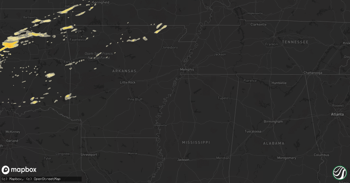
Hail Map in Nebraska on June 14, 2011
Get this storm
June 14 map
$229
one time, instant access
Download today. No call, no setup
Keep the $229
Bought the map and want the full workflow? Apply the entire $229 to a subscription within 7 days. None of it is wasted.
Every map, not just this one
This buys you this map. Subscription and you get every map we run, in the markets you choose from a few cities to whole states to nationwide. Plus real-time alerts the moment a storm fires.
Contact data
Name, contact info, occupancy, even credit band for addresses in the footprint. You go from where it hit to who to call.
Become the source they trust
Unlimited branding weather history reports on demand. You already have the documented answer ready for the property owner, and you are the one who showed up with it.
Property data and RoofTrace estimates
Pull up any address you have got, its value and the exact code rules for that jurisdiction, straight from One Click Code. Then RoofTrace estimates the squares, pitch, and roof value, priced the way you price.
Storm reports in Nebraska
Nebraska
| Date | Description |
|---|---|
| 06/14/20114:33 PM CDT | Rock county sherriff department reported marble and golf ball sized hail |
| 06/13/20119:12 PM CDT | A local report indicates 1.00 inch wind near 6 W BENEDICT |
| 06/13/20119:12 PM CDT | Corrected earlier report that placed event in furnas county. |
| 06/13/20119:00 PM CDT | A few quarter size...mostly nickels or smaller |
| 06/13/20119:00 PM CDT | Mostly nickel size hail fell for a short time. |
| 06/13/20118:56 PM CDT | Quarter size hail |
| 06/13/20118:50 PM CDT | A local report indicates 1.00 inch wind near 2 N POLK |
| 06/13/20118:40 PM CDT | Winds gusts estimated up to 55 to 60 mph. Also small hail. Corn shredded. 1.60 inches of rain. |
| 06/13/20118:37 PM CDT | Hail from roughly 827-837pm. Largest stones around ping pong size. |
| 06/13/20118:34 PM CDT | Also had 50 mph winds. |
| 06/13/20118:29 PM CDT | A local report indicates 1.00 inch wind near 5 E FULLERTON |
| 06/13/20118:12 PM CDT | A local report indicates 1.00 inch wind near 2 W FULLERTON |
| 06/13/20118:10 PM CDT | Brief ef0 tornado touched down in northern merrick county. Tornado was on the ground for approximately 5 to 10 minutes. |
| 06/13/20118:06 PM CDT | Custer county emergency manager reported numerous home windows broken in ansley from large jagged hail...along with trees stripped of foliage. Tennis ball sized hail fe |
| 06/13/20118:02 PM CDT | Estimated 60 mph winds and nickel size hail. Time estimated from radar. |
| 06/13/20117:40 PM CDT | Winds gusts estimated up to 55 to 60 mph. Also small hail. Corn shredded. 1.60 inches of rain. |
| 06/13/20117:36 PM CDT | Trained spotter reported quarter size hail to a little bit bigger at her home around 736 pm. |
| 06/13/20117:31 PM CDT | A local report indicates 1.00 inch wind near 2 S ELGIN |
| 06/13/20117:26 PM CDT | A local report indicates 1.75 inch wind near 2 S SPALDING |
| 06/13/20117:13 PM CDT | Public reported quarter and golf ball sized hail 2 miles north of ansley |
| 06/13/20117:11 PM CDT | The ground was almost white with hail pea size to half dollar size. Very little rain fell. |
| 06/13/20117:08 PM CDT | Ansley fire department reported that golf ball sized hail fell in ansley at 708 pm cdt |
All States Impacted by Hail Map on June 14, 2011
Cities Impacted by Hail Map on June 14, 2011
- Ashley, IL
- Tryon, NE
- Ord, NE
- Sugar City, CO
- Glenwood, MO
- Lancaster, MO
- Orlando, FL
- Talala, OK
- Rush, CO
- Derby, IN
- Cannelton, IN
- Union Star, KY
- Rome, IN
- Solen, ND
- Norman, OK
- Oklahoma City, OK
- Birmingham, IA
- Keosauqua, IA
- Stockport, IA
- Maitland, FL
- Altamonte Springs, FL
- Bassett, NE
- Newport, NE
- Central City, NE
- Belgrade, NE
- Clarks, NE
- Polk, NE
- Hordville, NE
- Palmer, NE
- Fullerton, NE
- Stromsburg, NE
- Mexico, MO
- Teutopolis, IL
- Sigel, IL
- Montrose, IL
- Broken Bow, NE
- Comstock, NE
- Stuart, FL
- Palm City, FL
- Jensen Beach, FL
- Williamsburg, MO
- Sanford, FL
- Olney Springs, CO
- Lake Worth, FL
- Boynton Beach, FL
- Ewing, MO
- Maywood, MO
- Durham, MO
- Seneca, MO
- Miami, OK
- Joplin, MO
- Quapaw, OK
- Neosho, MO
- Wyandotte, OK
- Diamond, MO
- Van Wert, IA
- Leon, IA
- Seymour, TX
- Maynard, AR
- Chickasha, OK
- Blanchard, OK
- Amber, OK
- Patrick Afb, FL
- Holliday, TX
- Sioux Center, IA
- Ireton, IA
- Rock Valley, IA
- Ansley, NE
- Carney, OK
- Chandler, OK
- Ethel, MO
- Kirksville, MO
- Brookfield, MO
- Green Castle, MO
- New Boston, MO
- Mims, FL
- Atkinson, NE
- Ordway, CO
- Cushing, OK
- Yukon, OK
- Mannford, OK
- Perkins, OK
- Bethany, OK
- Spencer, OK
- Agra, OK
- Bristow, OK
- Stroud, OK
- Ripley, OK
- Depew, OK
- Mustang, OK
- Drumright, OK
- Wellston, OK
- Arcadia, OK
- Luther, OK
- Tryon, OK
- Edmond, OK
- Jones, OK
- Chambers, NE
- Chenoa, IL
- Fairbury, IL
- Gravity, IA
- Larned, KS
- Moline, IL
- Rock Island, IL
- Milan, IL
- Muscatine, IA
- Sand Springs, OK
- Terlton, OK
- Jennings, OK
- El Reno, OK
- Yale, OK
- Union City, OK
- Raleigh, ND
- Bentonville, AR
- Cave Springs, AR
- Rogers, AR
- Moulton, IA
- Dubois, IN
- Vero Beach, FL
- Melbourne Beach, FL
- Webster, IA
- Sigourney, IA
- Bristow, IN
- Saint Meinrad, IN
- Tell City, IN
- Evanston, IN
- Burwell, NE
- Amelia, NE
- Lovilia, IA
- Chariton, IA
- Knoxville, IA
- Columbia, IA
- Russell, IA
- Kenansville, FL
- Lavaca, AR
- Charleston, AR
- Cecil, AR
- Springview, NE
- Long Pine, NE
- Madison, MO
- Holliday, MO
- Monmouth, IL
- Stonington, IL
- Blue Mound, IL
- Trenton, MO
- Chula, MO
- Humboldt, IL
- Meadville, MO
- New Smyrna Beach, FL
- Flasher, ND
- Shields, ND
- Hamilton, IL
- Niota, IL
- Nauvoo, IL
- Dallas City, IL
- Carthage, IL
- Osceola, IA
- Woodburn, IA
- Pana, IL
- Nokomis, IL
- Witt, IL
- Harvel, IL
- Litchfield, IL
- Morrisonville, IL
- Raymond, IL
- Irving, IL
- Butler, IL
- Carlinville, IL
- Waurika, OK
- New Leipzig, ND
- Plymouth, IL
- Saint Francisville, IL
- Vincennes, IN
- Lawrenceville, IL
- Albia, IA
- Bloomington, IN
- Springville, IN
- Beardstown, IL
- Buffalo, MO
- Everton, MO
- Morrisville, MO
- Springfield, MO
- Willard, MO
- Fair Grove, MO
- Brighton, MO
- Half Way, MO
- Pleasant Hope, MO
- Ash Grove, MO
- Greenfield, MO
- Walnut Grove, MO
- Bolivar, MO
- Marthasville, MO
- Keokuk, IA
- Kahoka, MO
- Alexandria, MO
- Sutter, IL
- Canton, MO
- Warsaw, IL
- Elvaston, IL
- Mendon, IL
- Williamstown, MO
- Monticello, MO
- Wayland, MO
- Argyle, IA
- Basco, IL
- Ursa, IL
- Wyaconda, MO
- Saint Patrick, MO
- West Point, IL
- Orient, SD
- Highmore, SD
- Seneca, SD
- Miller, SD
- Oak Hill, FL
- Van Meter, IA
- Prole, IA
- Cement, OK
- Graham, TX
- Bryson, TX
- Topeka, IL
- Havana, IL
- Manito, IL
- Glasford, IL
- Liverpool, IL
- Canton, IL
- Freedom, OK
- Oneill, NE
- Montreal, MO
- Linn Creek, MO
- Camdenton, MO
- Strasburg, ND
- Milan, MO
- Middletown, MO
- Bowling Green, MO
- Mediapolis, IA
- Danville, IA
- Sperry, IA
- Yarmouth, IA
- Attica, IN
- Mellott, IN
- Veedersburg, IN
- Wingate, IN
- Broken Bow, OK
- Loveland, OK
- Devol, OK
- Byers, TX
- Grandfield, OK
- Frederick, OK
- Temple, OK
- Wichita Falls, TX
- Randlett, OK
- Hollister, OK
- Walters, OK
- Wheeling, MO
- Linneus, MO
- Chillicothe, MO
- Dawn, MO
- Winner, SD
- Colome, SD
- Hampton, IA
- Geneva, FL
- Oviedo, FL
- Preston, MO
- Auxvasse, MO
- Benton City, MO
- Thompson, MO
- Rush Hill, MO
- Saint Peters, MO
- Saint Charles, MO
- Medina, ND
- Washington, OK
- Orleans, IN
- Harvey, IA
- Tracy, IA
- Soper, OK
- Boswell, OK
- Olney, TX
- High Hill, MO
- Barnes City, IA
- Elkland, MO
- Miller, MO
- Fair Play, MO
- Aldrich, MO
- South Greenfield, MO
- Dadeville, MO
- Lockwood, MO
- Prescott, IA
- Calico Rock, AR
- Melbourne, AR
- Osceola, NE
- Bloomfield, IA
- Hillsboro, IA
- Arbela, MO
- Bonaparte, IA
- Douds, IA
- Memphis, MO
- Milton, IA
- Cantril, IA
- Mount Sterling, IA
- Pulaski, IA
- Fortuna, MO
- Tipton, MO
- Florence, MO
- Versailles, MO
- Syracuse, MO
- Stover, MO
- Mora, MO
- Smithton, MO
- Nowata, OK
- Ramona, OK
- Bartlesville, OK
- Pocahontas, IA
- Rolfe, IA
- Loving, TX
- Taylorville, IL
- Assumption, IL
- Macon, IL
- Decatur, IL
- Moweaqua, IL
- Cedar Rapids, NE
- New Haven, MO
- Linton, ND
- Meeker, OK
- Shelbyville, IL
- Arthur, IL
- Findlay, IL
- Bethany, IL
- Sullivan, IL
- Windsor, IL
- Arcola, IL
- Oxford, FL
- Jud, ND
- Pleasantville, IA
- Heyworth, IL
- Waynesville, IL
- Clinton, IL
- Wapella, IL
- Glendale, KY
- Cecilia, KY
- Elizabethtown, KY
- Deland, FL
- Gilman, IL
- Burke, SD
- Arrowsmith, IL
- Le Roy, IL
- Unionville, MO
- Prague, OK
- Sparks, OK
- Peggs, OK
- Locust Grove, OK
- Rose, OK
- Paxton, IL
- Gibson City, IL
- Laredo, MO
- West Alton, MO
- Florissant, MO
- Godfrey, IL
- Hazelwood, MO
- Alton, IL
- Fort Pierce, FL
- Naper, NE
- Herrick, SD
- Gregory, SD
- Bonesteel, SD
- Rineyville, KY
- Vine Grove, KY
- Brimfield, IL
- Elmwood, IL
- Yates City, IL
- Laura, IL
- Williamsfield, IL
- Centerville, IA
- Udell, IA
- Jamestown, MO
- Clarksburg, MO
- California, MO
- Forrest, IL
- Lucas, IA
- Allerton, IA
- Corydon, IA
- Derby, IA
- Garden Grove, IA
- Humeston, IA
- Weldon, IA
- Lineville, IA
- Davis City, IA
- Decatur, IA
- Sulphur Springs, AR
- Hiwasse, AR
- Gravette, AR
- Maysville, AR
- Jay, OK
- Fairburn, SD
- Watson, OK
- Greenview, IL
- Winter Garden, FL
- Windermere, FL
- Cyril, OK
- Ninnekah, OK
- Cheyenne Wells, CO
- Arapahoe, CO
- Weskan, KS
- Stuart, NE
- Elizabeth, IN
- Brandenburg, KY
- Laconia, IN
- Calvin, OK
- Coalgate, OK
- Stuart, OK
- Apache, OK
- Fletcher, OK
- Elgin, OK
- La Plata, MO
- Humphreys, MO
- Elmer, MO
- Bucklin, MO
- Winigan, MO
- Purdin, MO
- Browning, MO
- Hale, MO
- Novinger, MO
- Braymer, MO
- Laclede, MO
- Watts, OK
- Westville, OK
- Fort Pierre, SD
- Meservey, IA
- Goodell, IA
- Ferdinand, IN
- Birdseye, IN
- Lacona, IA
- Comanche, OK
- Inola, OK
- Tolono, IL
- Ivesdale, IL
- Ottumwa, IA
- Cleveland, OK
- Centerton, AR
- Brussels, IL
- Golden Eagle, IL
- Gillespie, IL
- Bunker Hill, IL
- Bridgeton, MO
- Dow, IL
- Portage Des Sioux, MO
- Brighton, IL
- Shipman, IL
- Earth City, MO
- Elsah, IL
- Bethalto, IL
- Saint Louis, MO
- Selby, SD
- Brook, IN
- Morocco, IN
- Greeley, NE
- Wolbach, NE
- Bradshaw, NE
- Benedict, NE
- Genoa, NE
- Ericson, NE
- Spalding, NE
- Silver Creek, NE
- Primrose, NE
- Onaka, SD
- Tolstoy, SD
- Batavia, IA
- Agency, IA
- North English, IA
- South English, IA
- Weldon, IL
- Maroa, IL
- Argenta, IL
- Moffit, ND
- Braddock, ND
- Hazelton, ND
- Cincinnati, IA
- Huntingburg, IN
- Mapleton, IL
- Saint David, IL
- Bath, IL
- Peoria, IL
- Delavan, IL
- Trivoli, IL
- Green Valley, IL
- Lewistown, IL
- Oakford, IL
- Forest City, IL
- Hanna City, IL
- Kingston Mines, IL
- Easton, IL
- Mason City, IL
- Kilbourne, IL
- Pekin, IL
- Chandlerville, IL
- San Jose, IL
- Bellflower, MO
- Browning, IL
- Keota, IA
- Brighton, IA
- Washington, IA
- West Chester, IA
- Melcher Dallas, IA
- Flagler, CO
- Illiopolis, IL
- Mount Pulaski, IL
- Warrensburg, IL
- Latham, IL
- Rhineland, MO
- Mokane, MO
- New Florence, MO
- Steedman, MO
- Holts Summit, MO
- Tebbetts, MO
- Hermann, MO
- Fulton, MO
- New Bloomfield, MO
- Portland, MO
- Woodworth, ND
- Warm Springs, AR
- Pocahontas, AR
- Newcastle, OK
- North Loup, NE
- Ainsworth, IA
- Mount Pleasant, IA
- Crawfordsville, IA
- Olds, IA
- Winfield, IA
- Wayland, IA
- Lincoln, IL
- Antlers, OK
- Hugo, OK
- Decatur, TX
- Sunset, TX
- Bridgeport, TX
- Bowie, TX
- Jacksboro, TX
- Chico, TX
- Alvord, TX
- Penfield, IL
- Wahoo, NE
- Plattsmouth, NE
- Springfield, NE
- Ceresco, NE
- Gretna, NE
- Cedar Creek, NE
- Memphis, NE
- Louisville, NE
- Ashland, NE
- Ithaca, NE
- Shelbyville, MO
- Coldwater, KS
- Munfordville, KY
- Pollock, MO
- Macomb, IL
- Colchester, IL
- Bethel, MO
- Blandinsville, IL
- Augusta, IL
- Good Hope, IL
- Abingdon, IL
- Bardolph, IL
- Bushnell, IL
- Tennessee, IL
- Fort Madison, IA
- La Grange, MO
- London Mills, IL
- Galesburg, IL
- Berwick, IL
- Avon, IL
- Luray, MO
- La Harpe, IL
- Donnellson, IA
- Smithfield, IL
- Montrose, IA
- Media, IL
- West Point, IA
- Table Grove, IL
- Saint Augustine, IL
- Ellisville, IL
- Gilson, IL
- Lewistown, MO
- Farmington, IA
- Prairie City, IL
- Revere, MO
- Wever, IA
- Roseville, IL
- Raritan, IL
- Maquon, IL
- Bowen, IL
- Adair, IL
- La Belle, MO
- Cuba, IL
- Marietta, IL
- Gorin, MO
- Leitchfield, KY
- Harper, IA
- New London, IA
- Mount Union, IA
- The Villages, FL
- Greeley, CO
- Morriston, FL
- Clearwater, NE
- Ozone, AR
- Clarksville, AR
- Hagarville, AR
- Boyd, TX
- Paradise, TX
- Fort Worth, TX
- Justin, TX
- Rhome, TX
- Mattoon, IL
- Bloomington, IL
- Chamois, MO
- Morrison, MO
- Saint Edward, NE
- Albion, NE
- Indiahoma, OK
- Elgin, NE
- Winterset, IA
- Lorimor, IA
- Peru, IA
- Saint Charles, IA
- Reddick, IL
- Buckingham, IL
- Centertown, MO
- Mason City, NE
- Cameron, IL
- Atoka, OK
- Hoven, SD
- Caneyville, KY
- Westpoint, IN
- Lakefield, MN
- Spirit Lake, IA
- Jackson, MN
- Worthington, MN
- New Sharon, IA
- Rose Hill, IA
- Wildwood, FL
- Charleston, IL
- Westfield, IL
- Ashmore, IL
- Newman Grove, NE
- Tilden, NE
- Ewing, NE
- Petersburg, NE
- Indianola, IA
- Ackworth, IA
- Carlisle, IA
- Rush Springs, OK
- Watseka, IL
- Ozark, IL
- Mount Judea, AR
- Talihina, OK
- Exline, IA
- Garner, IA
- Aurora, MO
- Marionville, MO
- Gatewood, MO
- Harrah, OK
- Creston, IA
- Burlington, IA
- West Burlington, IA
- Morning Sun, IA
- Wapello, IA
- Bella Vista, AR
- Pineville, MO
- Shenandoah, IA
- Mills, NE
- Dallas, SD
- Britt, IA
- Edgeley, ND
- Oakville, IA
- Toledo, IL
- Monroe, NE
- Columbus, NE
- Saint Charles, SD
- Paoli, IN
- Reelsville, IN
- Olney, IL
- Claremont, IL
- Ravenden Springs, AR
- Couch, MO
- Eastview, KY
- Franklin, AR
- Galt, MO
- Parkersburg, IL
- Marshall, IL
- Grand River, IA
- Clio, IA
- New Virginia, IA
- Scotia, NE
- Melrose, IA
- Sarcoxie, MO
- Reeds, MO
- Carthage, MO
- Ashton, NE
- Farwell, NE
- Simpson, IL
- Hague, ND
- Lake Mary, FL
- Maysville, OK
- Cannon Ball, ND
- Greencastle, IN
- Eureka, SD
- Blakesburg, IA
- Moravia, IA
- Unionville, IA
- Eddyville, IA
- Clarinda, IA
- Farragut, IA
- Red Oak, OK
- Stephensport, KY
- Calhoun, IL
- Truro, IA
- Butte, NE
- Saybrook, IL
- New Market, IA
- Grannis, AR
- Wickes, AR
- Cove, AR
- Tuttle, OK
- Wright City, OK
- Valliant, OK
- Payneville, KY
- Webster, KY
- Stapleton, NE
- Arriba, CO
- Hugo, CO
- Wilburton, OK
- Robinson, IL
- Oblong, IL
- Davenport, OK
- Lamoure, ND
- Farmersville, IL
- Mount Vernon, MO
- Rossville, IL
- David City, NE
- Bellwood, NE
- Schuyler, NE
- Prue, OK
- Spiro, OK
- Danforth, IL
- Chelsea, OK
- Vinita, OK
- Mission, SD
- Wood, SD
- Sperry, OK
- Collinsville, OK
- Debary, FL
- Orange City, FL
- Hominy, OK
- Lawton, OK
- Miami, FL
- Freedom, IN
- Worthington, IN
- Bloomfield, IN
- Montgomery City, MO
- Jonesburg, MO
- Warrenton, MO
- Truxton, MO
- Deep River, IA
- Ladora, IA
- De Witt, NE
- Irvington, KY
- Cobden, IL
- Tulsa, OK
- Grinnell, IA
- Ottosen, IA
- Deltona, FL
- Osteen, FL
- Tecumseh, NE
- Adams, NE
- Fithian, IL
- Armstrong, IL
- Winchester, IL
- Maud, OK
- Litchfield, NE
- Lindsay, OK
- Curryville, MO
- Vandalia, MO
- Clayton, IL
- Newalla, OK
- Wagoner, OK
- Bement, IL
- Edinburg, IL
- Snow, OK
- Pryor, OK
- Chouteau, OK
- Loup City, NE
- Swan, IA
- Hackett, AR
- Bell, FL
- Trenton, FL
- Canton, SD
- Valley Springs, SD
- Larchwood, IA
- Brandon, SD
- Golden City, MO
- Jasper, MO
- Rockport, IL
- Shelburn, IN
- Jasonville, IN
- Sullivan, IN
- Langdon, ND
- Louisiana, MO
- Frankford, MO
- West Salem, IL
- Delta, IA
- Chestnut, IL
- Nashoba, OK
- Vienna, MO
- New Holland, IL
- Emden, IL
- Hartsburg, IL
- Hardinsburg, IN
- Queen City, MO
- Coatsville, MO
- Sharpsburg, IA
- Waverly, NE
- Shawnee, OK
- Hanston, KS
- Mansfield, IL
- De Land, IL
- Monticello, IL
- Farmer City, IL
- Papillion, NE
- Pacific Junction, IA
- Nebo, IL
- Pleasant Hill, IL
- Linn, MO
- Leopold, IN
- Harned, KY
- Leavenworth, IN
- Guston, KY
- Rhodelia, KY
- Battletown, KY
- Hawesville, KY
- Ekron, KY
- Lewisport, KY
- Hardinsburg, KY
- Skiatook, OK
- Rutledge, MO
- Williamsburg, IA
- Port Orange, FL
- Pawnee, IL
- Flat Rock, IL
- Chattanooga, OK
- Palm Beach, FL
- West Palm Beach, FL
- Lake Worth Beach, FL
- Chelsea, IA
- Bedford, IA
- Jerusalem, AR
- Seymour, IA
- Bennington, OK
- Taylor Ridge, IL
- Choctaw, OK
- Climax Springs, MO
- Castalian Springs, TN
- Gallatin, TN
- Durant, OK
- Madill, OK
- Saint Cloud, FL
- Winter Park, FL
- Apopka, FL
- Delray Beach, FL
- Longwood, FL
- Kanawha, IA
- Klemme, IA
- Wetumka, OK
- Milford, IL
- Hoopeston, IL
- East Galesburg, IL
- Thayer, IA
- Murray, IA
- Elkhart, IL
- Athens, IL
- Middletown, IL
- Minco, OK
- Morris, IL
- Mazon, IL
- Luverne, MN
- Cleveland, ND
- Pingree, ND
- Mcloud, OK
- Brumley, MO
- Branford, FL
- Mcalester, OK
- Augusta, MO
- Defiance, MO
- Saint Clair, MO
- Mitchell, IN
- Rockport, IN
- Richland, IN
- Crocker, MO
- Iberia, MO
- Genoa, CO
- Ravenden, AR
- Imboden, AR
- Switz City, IN
- Lyons, IN
- Goodland, IN
- Geneva, IA
- York, NE
- Mount Vernon, IL
- Garretson, SD
- Sidney, AR
- Evening Shade, AR
- Ash Flat, AR
- Horseshoe Bend, AR
- Bluffs, IL
- Chapin, IL
- Jasper, MN
- Spencer, IN
- Coal City, IN
- West Lebanon, IN
- Chatsworth, IL
- Quincy, IL
- Pahokee, FL
- Okeechobee, FL
- Belle Glade, FL
- Long Lane, MO
- Lockridge, IA
- Fort Smith, AR
- Bonfield, IL
- Trilla, IL
- Neoga, IL
- Delphi, IN
- Lafayette, IN
- Novelty, MO
- Macks Creek, MO
- Owensville, MO
- Gerald, MO
- Downs, IL
- Taylor, MO
- Lane, OK
- Hodgenville, KY
- Chebanse, IL
- Herscher, IL
- Pelsor, AR
- Kincaid, IL
- Richland, IA
- Wellman, IA
- Fowler, IN
- Meredosia, IL
- Bedford, IN
- Noble, OK
- Brookston, IN
- Yellville, AR
- Port Saint Lucie, FL
- Hobe Sound, FL
- Purcell, OK
- Wayne, OK
- Lexington, OK
- Hedrick, IA
- Hattiesburg, MS
- Hartman, AR
- Goodman, MO
- Titusville, FL
- Newtown, MO
- Bussey, IA
- Plano, IA
- Eldon, IA
- Myrtle, MO
- Garfield, KY
- Westview, KY
- Falls Of Rough, KY
- Columbus Junction, IA
- Reynolds, IL
- Emington, IL
- Odell, IL
- Dewitt, IL
- Niantic, IL
- Normal, IL
- Buffalo, IL
- McLean, IL
- Beason, IL
- Kenney, IL
- Lane, IL
- Petersburg, IL
- Atlanta, IL
- Lexington, IL
- Cooksville, IL
- Williamsville, IL
- Shirley, IL
- Ames, IA
- Clarks Hill, IN
- Mount Auburn, IL
- Rushville, IL
- French Lick, IN
- Huntsville, AR
- Pine Village, IN
- Cissna Park, IL
- Ludlow, IL
- Gifford, IL
- Rantoul, IL
- Rankin, IL
- Packwood, IA
- Ollie, IA
- Old Town, FL
- Sharon Springs, KS
- Colcord, OK
- Gann Valley, SD
- Eldon, MO
- Jasper, IN
- Lamar, OK
- Oologah, OK
- Sasakwa, OK
- Holdenville, OK
- Osage Beach, MO
- Lake Ozark, MO
- Kaiser, MO
- Boca Raton, FL
- Virginia, NE
- Steinauer, NE
- Pickrell, NE
- Lewiston, NE
- Beatrice, NE
- Filley, NE
- Crab Orchard, NE
- Campbellsburg, IN
- Salem, IN
- Vallonia, IN
- Mount Carmel, IL
- Cocoa, FL
- Edgewater, FL
- Cocoa Beach, FL
- Christmas, FL
- De Leon Springs, FL
- Pierson, FL
- Indianola, OK
- Kentland, IN
- Corwith, IA
- Emmet, NE
- Lake Wales, FL
- Le Mars, IA
- Kansas, IL
- Milford, NE
- Concord, IL
- Melvin, IL
- Loda, IL
- Roberts, IL
- Medicine Park, OK
- Bradley, OK
- Macomb, OK
- Alex, OK
- Tecumseh, OK
- Beaverville, IL
- Donovan, IL
- Osage, OK
- Buckley, IL
- Thawville, IL
- Big Clifty, KY
- White Mills, KY
- Petrolia, TX
- Seaton, IL
- Oquawka, IL
- Little York, IL
- Sibley, IL
- Salem, IA
- Stella, MO
- Pierce City, MO
- Monett, MO
- Purdy, MO
- Stark City, MO
- Fairview, MO
- Newburgh, IN
- Loxahatchee, FL
- Canal Point, FL
- Ponder, TX
- University Park, IA
- Oskaloosa, IA
- Arcadia, NE
- Westerville, NE
- Pontiac, IL
- Yoder, CO
- Lomax, IL
- Ardmore, OK
- Lone Grove, OK
- Deer Creek, IL
- Morton, IL
- What Cheer, IA
- Brashear, MO
- Washington, MO
- Leslie, MO
- Loraine, IL
- Bulpitt, IL
- Tovey, IL
- Virden, IL
- Palmer, IL
- Clarence, MO
- Leonard, MO
- Owasso, OK
- Catoosa, OK
- Claremore, OK
- Granby, MO
- Tunas, MO
- Louisburg, MO
- Polk, MO
- Urbana, MO
- Homestead, FL
- Owaneco, IL
- Beaufort, MO
- Sullivan, MO
- Union, MO
- Fredericksburg, IN
- Shelby, NE
- Hermosa, SD
- Villa Grove, IL
- Cache, OK
- Washington, IL
- Eureka, IL
- Seminole, OK
- Belmond, IA
- Battle Ground, IN
- Hawk Point, MO
- Silex, MO
- Bonnots Mill, MO
- Jefferson City, MO
- Armington, IL
- Marissa, IL
- Sparta, IL
- Kingman, IN
- Effingham, IL
- Carterville, IL
- Java, SD
- Mound City, SD
- Biggsville, IL
- Mill Creek, OK
- Dundas, IL
- Willow Hill, IL
- Eustis, FL
- Mercer, MO
- Centralia, MO
- Hallsville, MO
- Columbia, MO
- Lerna, IL
- Grandview, IN
- Potomac, IL
- Kingdom City, MO
- Sheffield, IA
- Camden, IL
- Champaign, IL
- Thomasboro, IL
- Montverde, FL
- Danville, IL
- Milo, IA
- Ochelata, OK
- Big Cabin, OK
- West Lafayette, IN
- Crawfordsville, IN
- Darlington, IN
- Marshall, AR
- Wesley, AR
- Laddonia, MO
- Brewster, MN
- La Russell, MO
- Stotts City, MO
- Makanda, IL
- Dustin, OK
- Bettendorf, IA
- Fairfield, IA
- George, IA
- Rock Rapids, IA
- Elmwood, NE
- Eagle Butte, SD
- Caddo, OK
- Rochester, IL
- Mechanicsburg, IL
- Harriet, AR
- Belle, MO
- Tappen, ND
- Ozark, AR
- Forsyth, IL
- Bismarck, IL
- Williamsport, IN
- Primghar, IA
- Hartley, IA
- Mount Sterling, IL
- Lake Helen, FL
- Woodlawn, IL
- Lenox, IA
- Martinton, IL
- Roach, MO
- Dardanelle, AR
- Havana, AR
- Orient, IA
- Stratton, CO
- West Liberty, IL
- Newton, IL
- Flippin, AR
- Maramec, OK
- Pocasset, OK
- Doon, IA
- Thurman, IA
- Yorktown, IA
- Percival, IA
- Sidney, IA
- Riverton, IA
- Clatonia, NE
- Bland, MO
- Micanopy, FL
- Archer, FL
- Faxon, OK
- Shelbina, MO
- Paris, MO
- Iowa Falls, IA
- Ackley, IA
- Windyville, MO
- Gladstone, IL
- Gainesville, FL
- Williston, FL
- Flora, IN
- Bringhurst, IN
- O'Brien, FL
- Mayo, FL
- Bainbridge, IN
- Fillmore, IN
- Tecumseh, MO
- Alexis, IL
- Kirkwood, IL
- Barling, AR
- Gridley, IL
- Berryville, AR
- Afton, IA
- Hopedale, IL
- Glenpool, OK
- Bixby, OK
- Jenks, OK
- Yutan, NE
- Billings, MO
- Sunrise Beach, MO
- Ringling, OK
- Villa Ridge, MO
- Dixon, MO
- Remington, IN
- Mackinaw, IL
- Minier, IL
- Saint Croix, IN
- English, IN
- Krum, TX
- Hull, IA
- Hawarden, IA
- Dalton City, IL
- Lovington, IL
- Belle Rive, IL
- Opdyke, IL
- Bonnie, IL
- Waltonville, IL
- Ina, IL
- Ewing, IL
- Republic, MO
- Cabery, IL
- Little Rock, IA
- Green City, MO
- Rattan, OK
- Gays, IL
- Corning, IA
- Cloverdale, IN
- Hulbert, OK
- Sibley, IA
- Edina, MO
- Kimball, SD
- Pukwana, SD
- Liberty, IL
- New Market, IN
- Mandan, ND
- Hartford, KY
- Fordsville, KY
- Eugene, MO
- Gentry, AR
- Decatur, AR
- Bicknell, IN
- Rocky Mount, MO
- Gravois Mills, MO
- Mount Olive, IL
- Cutler, IN
- Rossville, IN
- Wright City, MO
- Hammond, IL
- Loogootee, IN
- Aledo, IL
- Umpire, AR
- Kellyville, OK
- Sapulpa, OK
- Dysart, IA
- Keystone, IA
- Elberon, IA
- Wilson, OK
- Linden, IN
- Oakwood, IL
- Montgomery, IN
- Garden City, KS
- Stonewall, OK
- Lebanon Junction, KY
- Shepherdsville, KY
- Callender, IA
- Gowrie, IA
- Doniphan, MO
- Broken Arrow, OK
- Davidson, OK
- Wellington, IL
- Valparaiso, NE
- Bartlett, NE
- Richland, MO
- De Soto, IL
- Springdale, AR
- Fayetteville, AR
- Livonia, MO
- Downing, MO
- Melvin, IA
- Owensboro, KY
- Fulda, MN
- Verona, MO
- Palestine, IL
- Hutsonville, IL
- Merom, IN
- Williams, IN
- Cainsville, MO
- Boonville, IN
- Fairland, OK
- Carman, IL
- Hanna, OK
- Eufaula, OK
- Frederick, SD
- Rosamond, IL
- Ohlman, IL
- Peoria Heights, IL
- Lake Park, IA
- Dawson, ND
- Rocheport, MO
- Maitland, MO
- Garfield, KS
- Quinton, OK
- Saint Anthony, IN
- Celestine, IN
- Dell Rapids, SD
- Wanette, OK
- Bluejacket, OK
- Afton, OK
- Victoria, IL
- Tremont, IL
- Olaton, KY
- Mystic, IA
- Sheldon, IL
- Muldraugh, KY
- West Point, KY
- Fort Knox, KY
- Princeville, IL
- Rising City, NE
- Arkoma, OK
- Pocola, OK
- Granite City, IL
- Gardner, IL
- Loose Creek, MO
- Lindsay, NE
- Cisco, IL
- Hoyleton, IL
- Saint Joe, AR
- Oaktown, IN
- Otterbein, IN
- Tavares, FL
- Otwell, IN
- Cameron, OK
- Buchanan, ND
- Allendale, IL
- Bone Gap, IL
- Drakesville, IA
- Kansas, OK
- Pella, IA
- Leighton, IA
- Saunemin, IL
- Dwight, IL
- Kanaranzi, MN
- West Baden Springs, IN
- Keswick, IA
- Gibson, IA
- Lebanon, KY
- Mulberry, IN


