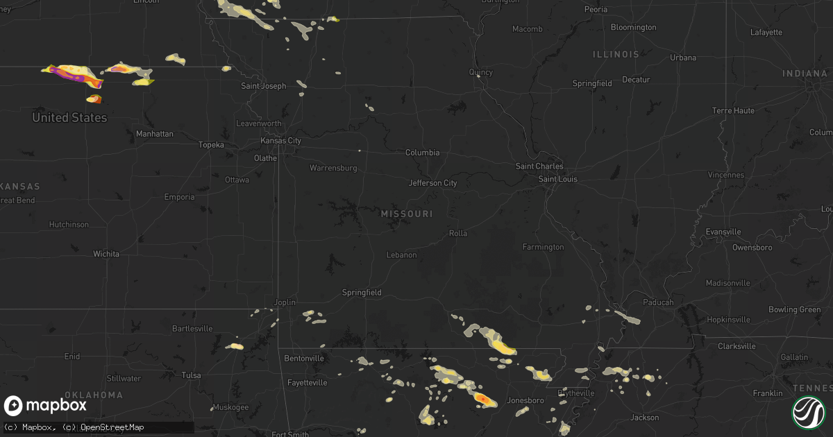
Hail Map in Missouri on June 13, 2026
Get this storm
June 13 map
$229
one time, instant access
Download today. No call, no setup
Keep the $229
Bought the map and want the full workflow? Apply the entire $229 to a subscription within 7 days. None of it is wasted.
Every map, not just this one
This buys you this map. Subscription and you get every map we run, in the markets you choose from a few cities to whole states to nationwide. Plus real-time alerts the moment a storm fires.
Contact data
Name, contact info, occupancy, even credit band for addresses in the footprint. You go from where it hit to who to call.
Become the source they trust
Unlimited branding weather history reports on demand. You already have the documented answer ready for the property owner, and you are the one who showed up with it.
Property data and RoofTrace estimates
Pull up any address you have got, its value and the exact code rules for that jurisdiction, straight from One Click Code. Then RoofTrace estimates the squares, pitch, and roof value, priced the way you price.
Storm reports in Missouri
Missouri
| Date | Description |
|---|---|
| 06/13/20261:40 PM CDT | Time estimated via radar. Report received via social media. |
| 06/13/202611:32 AM CDT | Mping report of downed tree limbs in bethany. Time confirmed from radar. |
| 06/13/202611:09 AM CDT | Corrects previous tstm wnd dmg report from webb city for date and time based on radar. Limbs from 1 up to 6 inch snapped... Roofs off of some businesses... And minor sh |
| 06/13/202611:07 AM CDT | Corrects previous tstm wnd dmg report from joplin for time. Numerous power lines down across the city of joplin. |
| 06/13/20262:37 AM CDT | Corrects previous tstm wnd gst report from 3 wsw dora for time based on radar. Mesonet station gw4435 dora. Poor radar presentation to support wind speeds reported. |
| 06/13/20262:09 AM CDT | Limbs from 1 up to 6 inch snapped... Roofs off of some businesses... And minor shingle damage. |
| 06/13/20261:59 AM CDT | Large tree down on east broadway in ava. Time estimated by radar. |
| 06/13/20261:59 AM CDT | Tree over the roadway at the corner of e benton ave and malone st. Time estimated by radar. |
| 06/13/20261:34 AM CDT | Tree down on hwy u between vv and spring hill. Time estimated from radar. |
| 06/13/20261:30 AM CDT | Tree down across roadway. Time estimated from radar. |
| 06/13/20261:20 AM CDT | Large tree down at oldfield rd at fairview rd in sparta. Time estimated by radar. |
| 06/13/20261:08 AM CDT | Tree branches in road and blocking road... Not overly large. Time estimated from radar. |
| 06/13/20261:06 AM CDT | 10 to 12 ft long branch... Possibly 2 ft in diameter... In middle of warren ave at 17th st. Time estimated from radar. |
| 06/13/20261:05 AM CDT | Large tree down across roadway at riverside road and greenbridge road. Time estimated from radar. |
| 06/13/20261:02 AM CDT | Tree down on state hwy f at cedar hills rd in ozark. Time estimated by radar. |
| 06/13/20261:02 AM CDT | Large tree covering road... Possibly both lanes. Time estimated by radar. |
| 06/13/202612:57 AM CDT | Tree down... About 40 inch wide on a house. |
| 06/13/202612:47 AM CDT | Large tree blocking both lanes on hidden valley rd at valley creek rd in clever. Time estimated from radar. |
| 06/13/202612:44 AM CDT | Tree down between tracker rd and charleston on phillips rd. Time estimated from radar. |
| 06/13/202612:43 AM CDT | Tree down across nelson mill rd in nixa. Time estimated from radar. |
| 06/13/202612:38 AM CDT | Power line down over road... Not entire roadway. Caller was able to drive under it but it was drooping badly. Time estimated from radar. |
| 06/13/202612:37 AM CDT | Butterfield fire is reporting power lines down at hwy 37 and hwy u on social media. |
| 06/13/202612:35 AM CDT | Tree down in roadway highway zz and central in marionville. Time estimated from radar. |
| 06/13/202612:35 AM CDT | Tree down on power line. Time estimated from radar. |
| 06/13/202612:30 AM CDT | Tree blocking road. Time estimated by radar. |
| 06/13/202612:28 AM CDT | Corrects previous non-tstm wnd dmg report from 4 nnw ritchey. Power lines down and tree debris across the roads reported from storm spotters. |
| 06/13/202612:25 AM CDT | Tree down on roadway. Time estimated from radar. |
| 06/13/202612:07 AM CDT | Numerous power lines down across the city of joplin. |
| 06/13/202612:00 AM CDT | Several broken tree branches outside cassville on 248. Time estimated from radar. |
| 06/12/202611:56 PM CDT | Large tree limbs down. |
| 06/12/202611:45 PM CDT | Tree down at deer creek rd and hwy 59. Time estimated from radar. |
| 06/12/202611:45 PM CDT | Measured 84mph winds through neosho on ridgewood road at 11:45pm. |
| 06/12/202611:41 PM CDT | Front porch blown off a house in fidelity 2 miles west of apple road and i49. |
| 06/12/202611:40 PM CDT | Power lines and limbs down. |
| 06/12/202611:37 PM CDT | Tree down on route d a half mile south of mcdonald road. |
| 06/12/202611:34 PM CDT | 4 miles south of carthage just north of i44 report of 80 mph winds. |
| 06/12/202611:32 PM CDT | Tree down per dispatch report. Time estimated from radar. |
| 06/12/202611:32 PM CDT | Report of downed tree branch blocking roadway. Time estimated from radar. |
| 06/12/202611:31 PM CDT | Tree down at school street and route 59. Time estimated by radar. |
| 06/12/202611:30 PM CDT | Metal frame barn tossed into the power lines with debris tossed across j into a field. Time estimated from radar. |
| 06/12/202611:25 PM CDT | Damage to a church in carthage. Time estimated from radar. |
| 06/12/202611:22 PM CDT | Several large tree limbs broken. Time estimated by radar. |
| 06/12/202611:19 PM CDT | Photos of uprooted tree that fell on house and numerous broken tree branches of various sizes. Time estimated by radar. |
| 06/12/202611:14 PM CDT | Our property has multiple uprooted trees in multiple directions down with telephone pole snapped. Time based on radar estimate. |
| 06/12/202611:13 PM CDT | Numerous uprooted trees and broken tree limbs. Photo of structure with blown in window and window screen near debris. Time estimated from radar. |
| 06/12/202611:12 PM CDT | Downed power lines near crab orchard road. Time estimated from radar. |
| 06/12/202611:10 PM CDT | Ambient personal weather station recorded a 61.7 mph gust. |
| 06/12/202611:09 PM CDT | Mo route hh |
| 06/12/202611:05 PM CDT | Corrects previous tstm wnd dmg report from 1 wnw joplin for time based on radar. Tree down... About 40 inch wide on a house. |
| 06/12/202611:04 PM CDT | East side of joplin two blocks west of rangeline road on texas ave from 8th to 15th street showing tree branches down and damage to storm door. |
| 06/12/202610:52 PM CDT | Downed trees closed route z. Time estimated from radar. |
| 06/12/202610:38 PM CDT | Downed tree and wires near route h. Time estimated from radar. |
| 06/12/202610:38 PM CDT | Mping report of downed tree limbs near plaza drive. Time estimated from radar. |
| 06/12/202610:35 PM CDT | Downed tree at a residence east of clinton. Time estimated from radar. |
| 06/12/202610:35 PM CDT | Downed power lines near shackelford bridge drive. Time estimated from radar. |
| 06/12/202610:32 PM CDT | Metal roofing from a garage was lifted and blown across the street. Time estimated from radar. |
| 06/12/202610:32 PM CDT | Social media report. Tree uprooted. Time estimated from radar. |
| 06/12/202610:32 PM CDT | Downed trees and limbs in much of marshall. Time estimated from radar. |
| 06/12/202610:31 PM CDT | Downed wires near route u. Time estimated from radar. |
| 06/12/202610:29 PM CDT | Mping report of power poles damaged and power lines down. Time estimated from radar. |
| 06/12/202610:11 PM CDT | Significant damage to outbuildings. Report relayed via social media. Time estimated from radar. |
| 06/12/202610:11 PM CDT | Downed trees and limbs in much of northwest pettis county. Time estimated from radar. |
| 06/12/202610:11 PM CDT | Mping report of power lines down in sweet springs. Time estimated from radar. |
| 06/12/202610:07 PM CDT | Private weather sensor. |
| 06/12/202610:05 PM CDT | Downed tree limb and power lines near northeast 75. Time estimated from radar. |
| 06/12/202610:02 PM CDT | Mping report of downed tree limbs. Time estimated from radar. |
| 06/12/202610:02 PM CDT | Mping report of downed tree limbs near route d. Time estimated from radar. |
| 06/12/20269:59 PM CDT | Mping report of downed tree limbs near route 23. Time estimated from radar. |
| 06/12/20269:52 PM CDT | Downed trees northeast of fayetteville. Time estimated from radar. |
| 06/12/20269:48 PM CDT | Private weather sensor. |
| 06/12/20269:37 PM CDT | Mping report of downed tree limbs. Time estimated from radar. |
| 06/12/20269:31 PM CDT | Several trees and limbs downed on the southwest side of odessa. Time estimated from radar. |
| 06/12/20269:31 PM CDT | A 2-foot-diameter tree fell on a house. Time estimated from radar. |
| 06/12/20269:28 PM CDT | Mping report of downed tree limbs. Time estimated from radar. |
| 06/12/20269:25 PM CDT | Tree split and limbs downed at a business in richmond. Time estimated from radar. |
| 06/12/20269:20 PM CDT | Public relayed photo of tree split. Time estimated from radar. |
| 06/12/20269:17 PM CDT | Public relayed report of several large tree branches down... Time estimated from radar. |
| 06/12/20269:12 PM CDT | Downed tree and power line near clearview drive. Time estimated from radar. |
| 06/12/20269:12 PM CDT | Social media report of downed trees in sibley. Time estimated from radar. |
| 06/12/20269:12 PM CDT | Several reports of trees and wires down in the oak grove area. Time estimated from radar. |
| 06/12/20269:12 PM CDT | Time estimated from radar. |
| 06/12/20269:09 PM CDT | Public relayed photo of trees blocking road... Location/time estimated from radar. |
| 06/12/20269:08 PM CDT | Public shared photo of large tree branch down on road. Time estimated from radar. |
| 06/12/20269:05 PM CDT | A local report indicates 60 MPH wind near 2 N Pleasant Hill |
| 06/12/20269:03 PM CDT | Several reports of downed tree limbs and wires east of freeman. Time estimated from radar. |
| 06/12/20269:02 PM CDT | No damage observed so far. |
| 06/12/20269:00 PM CDT | Downed tree. Report relayed via social media. Time estimate from radar. |
| 06/12/20269:00 PM CDT | Tree snapped. Report relayed via social media. Time estimated from radar. |
| 06/12/20269:00 PM CDT | Mping report of downed tree limbs near oxford lane. Time estimated from radar. |
| 06/12/20269:00 PM CDT | Several reports of downed tree limbs and wires near lake winnebago. Time estimated from radar. |
| 06/12/20269:00 PM CDT | Downed tree limbs throughout town. Time estimated from radar. |
| 06/12/20268:58 PM CDT | Mping report of downed tree limbs near alexander road. Time estimated from radar. |
| 06/12/20268:58 PM CDT | Mping report of downed tree libs near galazxy drive. Time estimated from radar. |
| 06/12/20268:58 PM CDT | Downed tree and wires near washington street. Time estimated from radar. |
| 06/12/20268:58 PM CDT | Large tree downed at a residence in raymore. Time estimated from radar. |
| 06/12/20268:56 PM CDT | Public relayed photo of tree branch split off from trunk... Time estimated from radar. |
| 06/12/20268:56 PM CDT | Image of large tree on house. Report relayed from social media. Time estimated from radar. |
| 06/12/20268:56 PM CDT | Downed tree limbs near route 7. Time estimated from radar. |
| 06/12/20268:53 PM CDT | Large tree branch broken. Time estimated from radar. |
| 06/12/20268:53 PM CDT | Large tree uprooted. Report relayed from social media. Time estimated from radar/. |
| 06/12/20268:53 PM CDT | Large tree limb down. Report relayed via social media. Time estimated from radar. |
| 06/12/20268:53 PM CDT | Mping report of downed tree limbs near route 7. Time estimated from radar. |
| 06/12/20268:53 PM CDT | Time estimated from radar. |
| 06/12/20268:53 PM CDT | Private weather sensor. |
| 06/12/20268:53 PM CDT | Limbs broken from tree. Report relayed from social media. Time estimated from radar. |
| 06/12/20268:53 PM CDT | Public relayed photo of large tree branch down. Time estimated from radar. |
| 06/12/20268:52 PM CDT | Downed tree at a residence west of kearney. Time estimated from radar. |
| 06/12/20268:51 PM CDT | Private weather sensor. |
| 06/12/20268:50 PM CDT | Several road barricades and multiple trees blown down in liberty. Time estimated from radar. |
| 06/12/20268:50 PM CDT | Images of trees damaged. Report relayed via social media. Time estimated from radar. |
| 06/12/20268:50 PM CDT | Multiple trees snapped or uprooted on south side of liberty. Time estimated from radar. |
| 06/12/20268:50 PM CDT | Downed tree limbs near 136th street. Time estimated from radar. |
| 06/12/20268:50 PM CDT | Public relayed photo of large tree branches down. Time estimated from radar. |
| 06/12/20268:49 PM CDT | Downed tree limbs and wires near u.s. 69. Time estimated from radar. |
| 06/12/20268:49 PM CDT | Private weather sensor. |
| 06/12/20268:48 PM CDT | Several downed limbs at a residence southeast of courtney. Time confirmed from radar. |
| 06/12/20268:48 PM CDT | Large branches broken from tree. Report relayed via social media. Time estimated from radar. |
| 06/12/20268:48 PM CDT | Private weather sensor. |
| 06/12/20268:48 PM CDT | Mping report of downed tree limbs near 43rd street. Time estimated from radar. |
| 06/12/20268:48 PM CDT | Mping report of downed tree limbs near sycamore terrace. Time estimated from radar. |
| 06/12/20268:48 PM CDT | Downed tree near i-70 and lees summit road. Time estimated from radar. |
| 06/12/20268:48 PM CDT | Downed tree limbs throughout independence. Time estimated from radar. |
| 06/12/20268:48 PM CDT | Public relayed photo of two large metal clothing bins blown over. Time estimated from radar. |
| 06/12/20268:47 PM CDT | Mping report of downed tree limbs near 103rd street. Time confirmed from radar. |
| 06/12/20268:47 PM CDT | Public relayed photos of large tree branches down... Obstructing roads and impacting structures. Time estimated by radar. |
| 06/12/20268:47 PM CDT | Public shared photo of large tree branch down in road. Time estimated from radar. |
| 06/12/20268:46 PM CDT | Public relayed photos of large tree branches down in house. Time estimated from radar. |
| 06/12/20268:46 PM CDT | Public shared photo of large tree branch down. Time estimated from radar. |
| 06/12/20268:45 PM CDT | Time estimated from radar. |
| 06/12/20268:45 PM CDT | Large tree down near 39th street. Time confirmed from radar. |
| 06/12/20268:44 PM CDT | Public relayed photo of large tree branch down... Obstructing road. Time estimated from radar. |
| 06/12/20268:42 PM CDT | Mping report of downed tree limbs near 96th street. Time confirmed from radar. |
| 06/12/20268:42 PM CDT | Public relayed photo of large tree branch/tree down... Time estimated from radar. |
| 06/12/20268:42 PM CDT | Public relayed video of large tree branch down. Time estimated from radar. |
| 06/12/20268:42 PM CDT | Public relayed report of large tree branch down. Time estimated from radar. |
| 06/12/20268:42 PM CDT | Sign overturned on i-435. Time estimated from radar. |
| 06/12/20268:42 PM CDT | Downed trees and power poles in pleasant valley. Time estimated from radar. |
| 06/12/20268:41 PM CDT | Public relayed video of large tree branches down. Time estimated from radar. |
| 06/12/20268:38 PM CDT | Large tree blown onto the road near the intersection of russell road and cleveland avenue. Time estimated from radar. |
| 06/12/20268:38 PM CDT | Mping report of downed tree limbs near topping avenue. Time estimated from radar. |
| 06/12/20268:38 PM CDT | Mping report of trees uprooted near cleveland avenue. Time estimated from radar. |
| 06/12/20268:36 PM CDT | Downed tree limbs near i-435 and u.s. 169. Time estimated from radar. |
| 06/12/20268:36 PM CDT | Mping report of downed power poles. Time estimated from radar. |
| 06/12/20268:36 PM CDT | Large limb downed onto house. Report relayed via social media. Time estimated from radar. |
| 06/12/20268:36 PM CDT | Mping report of downed tree limbs near indiana avenue. Time estimated from radar. |
| 06/12/20268:36 PM CDT | Large tree uprooted. Report relayed from social media. Time estimated from radar. |
| 06/12/20268:36 PM CDT | Image of tree uprooted. Report relayed from social media. Time estimated from radar. |
| 06/12/20268:36 PM CDT | Time estimated from radar. |
| 06/12/20268:36 PM CDT | Large tree uprooted. Report relayed via social media. Time estimated from radar. |
| 06/12/20268:35 PM CDT | Public relayed photo of large tree branches down. Time estimated from radar. |
| 06/12/20268:34 PM CDT | Photo shared of large tree branches down. Time estimated from radar. |
| 06/12/20268:33 PM CDT | Public relayed report of large tree branches down on power line. Time estimated from radar. |
| 06/12/20268:33 PM CDT | Mping report of downed tree limbs near bedford avenue. Time estimated from radar. |
| 06/12/20268:33 PM CDT | Mping report of uprooted trees near 76th street. Time estimated from radar. |
| 06/12/20268:32 PM CDT | Reported power outage due to storm damage. Time estimated from radar. |
| 06/12/20268:32 PM CDT | Several trees and limbs down in the tiffany springs area. Time estimated from radar. |
| 06/12/20268:31 PM CDT | Public relayed photo of tree down... Obstructing road. Time estimated from radar. |
| 06/12/20268:31 PM CDT | Large limb down. Report relayed from social media. Time estimate from radar. |
| 06/12/20268:30 PM CDT | Asos station kmci kansas city intl. |
| 06/12/20268:30 PM CDT | Public relayed photo of downed tree obstructing the off ramp. Time estimated from radar. |
| 06/12/20268:30 PM CDT | Several tree limbs down at a residence south of smithville. Time estimated from radar. |
| 06/12/20268:30 PM CDT | Large tree down over the road at northwood road and north merrimac avenue. |
| 06/12/20268:30 PM CDT | Multiple photos relayed of large tree branches down. Time estimated from radar. |
| 06/12/20268:30 PM CDT | Tree snapped. Report relayed via social media. Time estimated from radar. |
| 06/12/20268:30 PM CDT | Large tree branches snapped. Report relayed via social media. Time estimated from radar. |
| 06/12/20268:29 PM CDT | Mping report of downed tree limbs near 68th terrace. Time estimated from radar. |
| 06/12/20268:29 PM CDT | Public relayed photo of large tree branches down... Time estimated from radar. |
| 06/12/20268:29 PM CDT | Large limbs broken. Report relayed via social media. Time estimated from radar. |
| 06/12/20268:27 PM CDT | Many large trees snapped and branches and trunks split. At least 16 very large old trees shed large branches on property. Time estimated from radar. |
| 06/12/20268:25 PM CDT | Multiple trees... Power lines... And street signs down just east of kci airport. Time estimated from radar. |
| 06/12/20268:25 PM CDT | Large limbs broken. Report relayed via social media. Time estimated from radar. |
| 06/12/20268:25 PM CDT | Public related photo of tree down... Describes damage as broken halfway up the trunk. Time estimated from radar. |
| 06/12/20268:24 PM CDT | Public relayed photo of large tree branch down. Time estimated from radar. |
| 06/12/20268:24 PM CDT | Downed trees and wires in several locations near platte city. Time estimated from radar. |
| 06/12/20268:24 PM CDT | Public relayed photo of large tree branch obstructing road. Time estimated from radar. |
| 06/12/20268:22 PM CDT | Shingles blown off a residence near oak creek court. Time estimated from radar. |
| 06/12/20268:22 PM CDT | Photos shared of several large tree branches down... Time estimated by radar. |
| 06/12/20268:22 PM CDT | Barn roof torn off and a large tree downed on farley road. Time estimated from radar. |
| 06/12/20268:22 PM CDT | Public relayed photo of large tree branch down. Time estimated from radar. |
| 06/12/20268:21 PM CDT | Mping report of downed tree limbs near oak creek court. Time confirmed from radar. |
| 06/12/20268:20 PM CDT | Downed trees on route 45 between beverly and farley. Time estimated from radar. |
| 06/12/20268:20 PM CDT | Downed tree near apple blossom drive. Time estimated from radar. |
| 06/12/20268:18 PM CDT | Downed trees on route jj east of weston. Time estimated from radar. |
| 06/12/20268:16 PM CDT | Downed tree into power lines on route p. Time estimated from radar. |
| 06/12/20268:15 PM CDT | Outage reported due to storm damage... Time estimated from radar. |
| 06/12/20268:05 PM CDT | Relayed report of downed trees partially in the road. Time estimated from radar. |
| 06/12/20268:04 PM CDT | Large tree branches down. Time estimate via radar. |
All States Impacted by Hail Map on June 13, 2026
Cities Impacted by Hail Map on June 13, 2026
- Platte Center, NE
- Columbus, NE
- Leigh, NE
- Clarkson, NE
- Wisner, NE
- Pender, NE
- Silver Creek, NE
- Clarks, NE
- Osceola, NE
- Fullerton, NE
- Genoa, NE
- Polk, NE
- Schuyler, NE
- Benedict, NE
- Stromsburg, NE
- Bancroft, NE
- Haskell, OK
- Sloan, IA
- Winnebago, NE
- Salix, IA
- David City, NE
- Linwood, NE
- Walthill, NE
- Rosalie, NE
- Rogers, NE
- Shelby, NE
- Gresham, NE
- Whiting, IA
- York, NE
- Waco, NE
- Dodge, NE
- Ulysses, NE
- Surprise, NE
- Macy, NE
- Morse Bluff, NE
- Abie, NE
- Bellwood, NE
- Hornick, IA
- Cedar Bluffs, NE
- Rising City, NE
- North Bend, NE
- Malmo, NE
- Prague, NE
- Dwight, NE
- Brainard, NE
- Colon, NE
- Mead, NE
- Yutan, NE
- Staplehurst, NE
- Utica, NE
- Fremont, NE
- Ames, NE
- Wahoo, NE
- Weston, NE
- Valley, NE
- Smithland, IA
- La Vista, NE
- Omaha, NE
- Waterloo, NE
- Mapleton, IA
- Oto, IA
- Gretna, NE
- Ashland, NE
- Elkhorn, NE
- Anthon, IA
- Arlington, NE
- Bennington, NE
- Kennard, NE
- Blair, NE
- Fort Calhoun, NE
- Washington, NE
- Offutt Afb, NE
- Bellevue, NE
- Boys Town, NE
- Papillion, NE
- Carter Lake, IA
- Missouri Valley, IA
- Honey Creek, IA
- Crescent, IA
- Council Bluffs, IA
- Underwood, IA
- McClelland, IA
- Glenwood, IA
- Treynor, IA
- Silver City, IA
- Mineola, IA
- Macomb, IL
- Industry, IL
- Pacific Junction, IA
- Murray, NE
- Plattsmouth, NE
- Neola, IA
- Minden, IA
- Macedonia, IA
- Oakland, IA
- Carson, IA
- Henderson, IA
- Adair, IL
- Tabor, IA
- Malvern, IA
- Thurman, IA
- Griswold, IA
- Emerson, IA
- Red Oak, IA
- Elliott, IA
- Randolph, IA
- Farragut, IA
- Sidney, IA
- Riverton, IA
- Hastings, IA
- Imogene, IA
- Shenandoah, IA
- Coin, IA
- Essex, IA
- Northboro, IA
- Blanchard, IA
- Clarinda, IA
- College Springs, IA
- New Market, IA
- Braddyville, IA
- Houstonia, MO
- Sweet Springs, MO
- Gravity, IA
- Villisca, IA
- Nodaway, IA
- Shambaugh, IA
- Clearmont, MO
- Elmo, MO
- Stanton, IA
- Bedford, IA
- Hopkins, MO
- Pickering, MO
- Sharpsburg, IA
- Lenox, IA
- Corning, IA
- Sheridan, MO
- Parnell, MO
- Grant City, MO
- Blockton, IA
- Cameron, MO
- Martinsville, MO
- Denver, MO
- Stanberry, MO
- Gentry, MO
- Berwick, IA
- Ankeny, IA
- Altoona, IA
- Hatfield, MO
- Eagleville, MO
- Albany, MO
- New Hampton, MO
- Bethany, MO
- Cainsville, MO
- Blythedale, MO
- Davis City, IA
- Pattonsburg, MO
- Pomona, MO
- Willow Springs, MO
- Mountain View, MO
- Jameson, MO
- Jamesport, MO
- Gilman City, MO
- Turney, MO
- West Plains, MO
- Chillicothe, MO
- Harrison, AR
- Peace Valley, MO
- Yellville, AR
- Lead Hill, AR
- Alton, MO
- Lachine, MI
- Alpena, MI
- Posen, MI
- Deep River, IA
- Birch Tree, MO
- Victor, IA
- Koshkonong, MO
- Williamsburg, IA
- Millersburg, IA
- North English, IA
- Ladora, IA
- Norfork, AR
- Calico Rock, AR
- Winnabow, NC
- Webster, IA
- Herron, MI
- Dolph, AR
- Elizabeth, AR
- Parnell, IA
- Mountain Home, AR
- Wilmington, NC
- Hubbard Lake, MI
- Ossineke, MI
- Henderson, AR
- Couch, MO
- Bexar, AR
- Wideman, AR
- Triplett, MO
- Doniphan, MO
- Brunswick, MO
- Gatewood, MO
- Warm Springs, AR
- Myrtle, MO
- Norfolk, NE
- Oxford, AR
- Gepp, AR
- Pineville, AR
- Salem, AR
- Brockwell, AR
- Pocahontas, AR
- Maynard, AR
- Horseshoe Bend, AR
- Wiseman, AR
- Violet Hill, AR
- Hampstead, NC
- Rocky Point, NC
- Oran, MO
- Vanduser, MO
- Bell City, MO
- Melbourne, AR
- Sage, AR
- Franklin, AR
- Homer, NE
- Essex, MO
- Sikeston, MO
- Paragould, AR
- Okeechobee, FL
- Ravenden Springs, AR
- Decatur, MS
- Moville, IA
- Climbing Hill, IA
- Evening Shade, AR
- Imboden, AR
- Marmaduke, AR
- Rector, AR
- Alpena, AR
- Sidney, AR
- Mount Pleasant, AR
- Guion, AR
- Beemer, NE
- Delaplaine, AR
- Charleston, MO
- Seligman, MO
- Waverly, GA
- Quincy, IL
- Biggers, AR
- Oakland, TN
- Somerville, TN
- Cave City, AR
- Everton, AR
- Chipley, FL
- Panama City, FL
- Beech Grove, AR
- Longs, SC
- Aurora, NC
- Sulphur Rock, AR
- Valley Springs, AR
- Craig, NE
- Poughkeepsie, AR
- Hayti, MO
- Bragg City, MO
- Townsend, GA
- Lumber Bridge, NC
- Saint Pauls, NC
- Providence, KY
- Bristol, GA
- Mershon, GA
- Screven, GA
- Wewahitchka, FL
- Saint Joe, AR
- Lafe, AR
- Decatur, NE
- Pollocksville, NC
- Trenton, NC
- New Bern, NC
- Blytheville, AR
- Cord, AR
- Tekamah, NE
- Blencoe, IA
- Bardwell, KY
- Corinth, MS
- Parkton, NC
- Nebo, KY
- Strawberry, AR
- Smithville, AR
- Jonesboro, AR
- Charlotte, AR
- Batesville, AR
- Marston, MO
- Bronson, IA
- Manitou, KY
- Madisonville, KY
- Bay, AR
- Arlington, KY
- Obion, TN
- Tiptonville, TN
- Hickman, KY
- Newark, AR
- Saffell, AR
- Tuckerman, AR
- Burr Oak, KS
- Jacksonville, FL
- Harriet, AR
- Bryceville, FL
- Saint George, GA
- Steele, MO
- Caruthersville, MO
- Williams, AZ
- Mankato, KS
- Green Forest, AR
- Webber, KS
- Superior, NE
- Fancy Farm, KY
- Maysville, NC
- White Oak, NC
- Harrisburg, AR
- Weiner, AR
- Hilliard, FL
- Omaha, AR
- Cardwell, MO
- Newport, AR
- Swifton, AR
- Ridgely, TN
- Newbern, TN
- Conway, SC
- Hanson, KY
- Courtland, KS
- Hardy, NE
- Republic, KS
- Goodwell, OK
- Trimble, TN
- Mountain View, AR
- Manila, AR
- Marshall, AR
- Purdy, MO
- Kenton, TN
- Dover, AR
- London, AR
- Knoxville, AR
- Lamar, AR
- Mahaska, KS
- Fifty Six, AR
- Ravenden, AR
- Shirley, AR
- Granby, MO
- Stark City, MO
- Gainesville, AL
- Garland, NC
- Timbo, AR
- Pamplico, SC
- Narka, KS
- Fairbury, NE
- Morrowville, KS
- Moscow, KS
- Satanta, KS
- Epes, AL
- Fox, AR
- Edgemont, AR
- Ripley, TN
- Pierce City, MO
- Dyess, AR
- Osceola, AR
- Etowah, AR
- Lepanto, AR
- Fairview, MO
- Monett, MO
- Wyandotte, OK
- Belleville, KS
- Hollenberg, KS
- Endicott, NE
- Steele City, NE
- Dyer, TN
- Byron, NE
- Burchard, NE
- Prim, AR
- Dyersburg, TN
- Greenfield, TN
- Sharon, TN
- Rutherford, TN
- Wentworth, MO
- Marked Tree, AR
- Henning, TN
- Whiteville, NC
- Bradford, TN
- Sacramento, KY
- Huntsville, AR
- Washington, KS
- Scandia, KS
- Pawnee City, NE
- Big Cabin, OK
- Century, FL
- Seneca, MO
- Friendship, TN
- Quitman, GA
- Adair, OK
- Trenton, TN
- Fairfield Bay, AR
- Wilson, AR
- Joiner, AR
- Chelsea, OK
- Hanover, KS
- Barnes, KS
- McCrory, AR
- Bremen, KS
- Marysville, KS
- Waterville, KS
- McKenzie, TN
- Munden, KS
- Cuba, KS
- Arcadia, FL
- Higden, AR
- Drasco, AR
- Welch, OK
- Pantego, NC
- Vinita, OK
- Bee Branch, AR
- Gleason, TN
- Clinton, AR
- Diller, NE
- Frenchmans Bayou, AR
- Hiawatha, KS
- Zolfo Springs, FL
- Agenda, KS
- Concordia, KS
- Sublette, KS
- Milan, TN
- Steinauer, NE
- Du Bois, NE
- White Cloud, KS
- Quitman, AR
- Oketo, KS
- Quapaw, OK
- Clyde, KS
- Baxter Springs, KS
- Tumbling Shoals, AR
- Ida, AR
- Miami, OK
- Pinetown, NC
- Huntingdon, TN
- Drummonds, TN
- Turrell, AR
- Heber Springs, AR
- Haddam, KS
- Jetmore, KS
- Clifton, KS
- Aurora, KS
- Millington, TN
- Parsons, TN
- Linden, TN
- Keyes, OK
- Rush Center, KS
- Fort McCoy, FL
- Bern, KS
- Seneca, KS
- Home, KS
- Linn, KS
- Beattie, KS
- Williston, TN
- Wynne, AR
- Rulo, NE
- Sumner, GA
- Ashburn, GA
- Greenleaf, KS
- Palmer, KS
- Frankfort, KS
- Morganville, KS
- Ellsworth, KS
- Lorraine, KS
- Medford, OK
- Rozel, KS
- Fitzgerald, GA
- Galena, KS
- Georgetown, SC
- Hanston, KS
- Exeter, MO
- Rocky Comfort, MO
- Burdett, KS
- Humboldt, NE
- Fairfax, MO
- Deer, AR
- Sugar Tree, TN
- Braman, OK
- Eucha, OK
- Larned, KS
- Randolph, KS
- Blue Rapids, KS
- Green, KS
- Spearville, KS
- Skidmore, MO
- Deer Creek, OK
- Pawnee Rock, KS
- Great Bend, KS
- Liberal, KS
- Wakita, OK
- Kinsley, KS
- Holladay, TN
- Burlington Junction, MO
- Maryville, MO
- Proctor, AR
- Clay Center, KS
- Afton, OK
- Kanopolis, KS
- South Haven, KS
- Caldwell, KS
- Nardin, OK
- Otis, KS
- Cedarcreek, MO
- Geneseo, KS
- Crawfordsville, AR
- Canadian, TX
- Vermillion, KS
- Kirbyville, MO
- West Memphis, AR
- Edmondson, AR
- Leonardville, KS
- Hagarville, AR
- Jay, OK
- Brookville, KS
- Worth, MO
- Manhattan, KS
- Westmoreland, KS
- Olsburg, KS
- Arkansas City, KS
- Geuda Springs, KS
- Oxford, KS
- Winfield, KS
- Albert, KS
- Olmitz, KS
- Wright, KS
- Dodge City, KS
- Ford, KS
- Lobelville, TN
- Riley, KS
- Blackwell, OK
- Lake Cormorant, MS
- Sabetha, KS
- Oneida, KS
- Marion, AR
- Grove, OK
- Wakefield, KS
- Offerle, KS
- Maitland, MO
- Mound City, MO
- Udall, KS
- Powhattan, KS
- Axtell, KS
- Fairview, KS
- Wetmore, KS
- Whiting, KS
- Baileyville, KS
- Netawaka, KS
- Centralia, KS
- Holton, KS
- Summerfield, KS
- Circleville, KS
- Horton, KS
- Corning, KS
- Goff, KS
- Onaga, KS
- Salina, KS
- Marianna, AR
- Havensville, KS
- Soldier, KS
- Centerville, TN
- New Cambria, KS
- Solomon, KS
- Walls, MS
- Grayville, IL
- Little River, KS
- Ellinwood, KS
- Claflin, KS
- Grand Junction, TN
- Moscow, TN
- Lamont, OK
- Bushton, KS
- Effingham, KS
- Muscotah, KS
- Ravenwood, MO
- Wamego, KS
- Saint George, KS
- Mayetta, KS
- Belvue, KS
- Saint Marys, KS
- Delia, KS
- Emmett, KS
- Lyons, KS
- Garfield, KS
- Bucklin, KS
- Hoyt, KS
- Valley Falls, KS
- Denison, KS
- Everest, KS
- Lancaster, KS
- Rossville, KS
- Paxico, KS
- Alma, KS
- Junction City, KS
- Ogden, KS
- Fort Riley, KS
- Milford, KS
- Sanford, FL
- Hughes, AR
- Ponca City, OK
- Fairland, OK
- Miami, TX
- Hohenwald, TN
- Minneola, KS
- Belpre, KS
- Hoisington, KS
- Hickory Valley, TN
- Bluejacket, OK
- Geneseo, IL
- Assaria, KS
- Gypsum, KS
- Macksville, KS
- St John, KS
- Burden, KS
- Rock, KS
- Chase, KS
- Corona, NM
- Stratford, TX
- Pratt, KS
- Atlanta, KS
- Deltona, FL
- Maysville, AR
- Gravette, AR
- Abilene, KS
- Saulsbury, TN
- Atchison, KS
- Cummings, KS
- Nortonville, KS
- Topeka, KS
- Silver Lake, KS
- Meriden, KS
- Maple Hill, KS
- Oskaloosa, KS
- Ozawkie, KS
- Grantville, KS
- Perry, KS
- Winchester, KS
- Tecumseh, KS
- Council Grove, KS
- Alta Vista, KS
- Dwight, KS
- White City, KS
- McFarland, KS
- Byers, KS
- Tonkawa, OK
- Douglass, KS
- Enterprise, KS
- Lewis, KS
- Weed, NM
- Hampshire, TN
- Gentry, AR
- Colcord, OK
- Decatur, AR
- Turon, KS
- Cunningham, KS
- Lakeland, FL
- Walnut, MS
- Latham, KS
- Iuka, KS
- Pretty Prairie, KS
- Arlington, KS
- Kingman, KS
- Stafford, KS
- Raymond, KS
- Spearman, TX
- Manter, KS
- Higgins, TX
- Mount Pleasant, TN
- Eskridge, KS
- Johnson, KS
- Richfield, KS
- Walsh, CO
- McLouth, KS
- Leavenworth, KS
- Rushville, MO
- Linwood, KS
- Lecompton, KS
- Berryton, KS
- Lawrence, KS
- Weston, MO
- Tonganoxie, KS
- De Kalb, MO
- Platte City, MO
- Baldwin City, KS
- Fort Leavenworth, KS
- Easton, KS
- Harveyville, KS
- Allen, KS
- Wilsey, KS
- Amarillo, TX
- Marland, OK
- Hunter, OK
- Lost Springs, KS
- Ramona, KS
- Tampa, KS
- Rose Hill, KS
- Haviland, KS
- Pinon, NM
- Belle Plaine, KS
- Masterson, TX
- Augusta, KS
- Lansing, KS
- Lenexa, KS
- Basehor, KS
- Kansas City, MO
- Farley, MO
- Bonner Springs, KS
- Shawnee, KS
- Kansas City, KS
- De Soto, KS
- Eudora, KS
- Waldron, MO
- Cloudcroft, NM
- Camden Point, MO
- Olathe, KS
- Riverside, MO
- Edgerton, KS
- New Century, KS
- Gardner, KS
- Overland Park, KS
- Mission, KS
- Wellsville, KS
- Burlingame, KS
- Auburn, KS
- Reading, KS
- Scranton, KS
- Admire, KS
- Osage City, KS
- Emporia, KS
- Americus, KS
- Severy, KS
- Piedmont, KS
- Howard, KS
- Nashville, KS
- Murdock, KS
- Spivey, KS
- Harper, KS
- Milton, KS
- Zenda, KS
- Cheney, KS
- Garden Plain, KS
- Norwich, KS
- Ralston, OK
- Fairfax, OK
- Red Rock, OK
- Pawnee, OK
- Durham, OK
- Keosauqua, IA
- Columbus, KS
- Viola, KS
- Goddard, KS
- Lincolnville, KS
- Tunica, MS
- Clearwater, KS
- Wichita, KS
- Leon, KS
- Sawyer, KS
- Mulvane, KS
- Bentonville, AR
- Conway Springs, KS
- Argonia, KS
- Danville, KS
- Colwich, KS
- Milan, KS
- Andale, KS
- Scammon, KS
- Cedar Point, KS
- Florence, KS
- Wellington, KS
- Isabel, KS
- Medicine Lodge, KS
- Strong City, KS
- Elmdale, KS
- Springdale, AR
- Fayetteville, AR
- Burns, KS
- Peabody, KS
- Newton, KS
- Vega, TX
- Fall River, KS
- Toronto, KS
- Yates Center, KS
- Waverly, KS
- Parsons, KS
- McCune, KS
- Smithville, MO
- Kearney, MO
- Edgerton, MO
- Liberty, MO
- Independence, MO
- Prairie Village, KS
- Leawood, KS
- Stilwell, KS
- Cleveland, MO
- Spring Hill, KS
- Peculiar, MO
- Grandview, MO
- Raymore, MO
- Belton, MO
- Bucyrus, KS
- Lees Summit, MO
- Lyndon, KS
- Lebo, KS
- Olpe, KS
- Neosho Rapids, KS
- Missouri City, MO
- Greenwood, MO
- Pleasant Hill, MO
- Blue Springs, MO
- Vassar, KS
- Quenemo, KS
- Melvern, KS
- Overbrook, KS
- Hartford, KS
- Attica, KS
- Perryton, TX
- Haysville, KS
- Erie, KS
- Kim, CO
- Cottonwood Falls, KS
- Westphalia, KS
- Witts Springs, AR
- Sharon, KS
- Weir, KS
- Derby, KS
- Holt, MO
- Excelsior Springs, MO
- Orrick, MO
- Grain Valley, MO
- Buckner, MO
- Sibley, MO
- Oak Grove, MO
- Harrisonville, MO
- Wynona, OK
- Hominy, OK
- Cleveland, OK
- Osage, OK
- Richmond, KS
- Le Roy, KS
- Welda, KS
- Ottawa, KS
- Pomona, KS
- Garnett, KS
- Colony, KS
- Burlington, KS
- Princeton, KS
- Williamsburg, KS
- Peck, KS
- Mayfield, KS
- Mcconnell Afb, KS
- Ulysses, KS
- Hereford, TX
- Las Animas, CO
- Roswell, NM
- Galesburg, KS
- El Dorado, KS
- Eureka, KS
- Matfield Green, KS
- Hamilton, KS
- Wellington, MO
- Napoleon, MO
- Lone Jack, MO
- Kingsville, MO
- Bates City, MO
- Richmond, MO
- Strasburg, MO
- Garden City, MO
- Camden, MO
- Levasy, MO
- Newkirk, OK
- Saint Paul, KS
- Cherokee, KS
- Pritchett, CO
- Stark, KS
- Pittsburg, KS
- Rosalia, KS
- Cassoday, KS
- Odessa, MO
- Lexington, MO
- Mayview, MO
- Holden, MO
- Centerview, MO
- Henrietta, MO
- Cambridge, KS
- Barnsdall, OK
- Skiatook, OK
- Prue, OK
- Wildorado, TX
- Benedict, KS
- Red Bay, AL
- Hazelton, KS
- Waldron, KS
- Freedom, OK
- Walnut, KS
- Girard, KS
- Chanute, KS
- Gridley, KS
- Wilmore, KS
- Coldwater, KS
- Humboldt, KS
- Garber, OK
- Maple City, KS
- Sedan, KS
- Cedar Vale, KS
- Billings, OK
- Shidler, OK
- Grenola, KS
- Pond Creek, OK
- Dexter, KS
- Moline, KS
- Kaw City, OK
- Mound City, KS
- Blue Mound, KS
- Fort Scott, KS
- Fulton, KS
- Greeley, KS
- Mapleton, KS
- Kincaid, KS
- Centerville, KS
- Prescott, KS
- Neal, KS
- Elsmore, KS
- Madison, KS
- La Harpe, KS
- Virgil, KS
- Piqua, KS
- Buffalo, KS
- Longton, KS
- Uniontown, KS
- Iola, KS
- Moran, KS
- Savonburg, KS
- Redfield, KS
- Neosho Falls, KS
- Beaumont, KS
- Bronson, KS
- Fredonia, KS
- Whiteman Air Force Base, MO
- Warrensburg, MO
- Blackburn, MO
- Corder, MO
- Windsor, MO
- La Monte, MO
- Marshall, MO
- Alma, MO
- Higginsville, MO
- Knob Noster, MO
- Chilhowee, MO
- Concordia, MO
- Leeton, MO
- Panhandle, TX
- Hughesville, MO
- Nelson, MO
- Smithton, MO
- Sedalia, MO
- Green Ridge, MO
- Thayer, KS
- Altoona, KS
- Neodesha, KS
- Liberty, KS
- Deerfield, MO
- Dennis, KS
- Hepler, KS
- Farlington, KS
- Elk City, KS
- Cherryvale, KS
- Independence, KS
- Elk Falls, KS
- Richards, MO
- Perry, OK
- Morrison, OK
- Burbank, OK
- Pawhuska, OK
- Lake City, KS
- Russellville, AL
- Anthony, KS
- Amorita, OK
- Manchester, OK
- Opolis, KS
- Asbury, MO
- Alva, OK
- Wayland, MO
- Kahoka, MO
- Glennie, MI
- Mikado, MI
- Harrisville, MI
- West Mineral, KS
- Mindenmines, MO
- Oronogo, MO
- Burlington, OK
- Cherokee, OK
- Jet, OK
- Argyle, IA
- Farmington, IA
- Franklin, KS
- Altamont, KS
- Edna, KS
- Chetopa, KS
- Arma, KS
- Oswego, KS
- Moundville, MO
- Arcadia, KS
- Mulberry, KS
- Liberal, MO
- Lamar, MO
- Coffeyville, KS
- Frontenac, KS
- Bronaugh, MO
- Mound Valley, KS
- Bartlett, KS
- Garland, KS
- Carl Junction, MO
- Tipton, MO
- Otterville, MO
- Prairie Home, MO
- Syracuse, MO
- California, MO
- Boonville, MO
- Franklin, MO
- Blackwater, MO
- Florence, MO
- Bunceton, MO
- Jamestown, MO
- Clarksburg, MO
- Wooldridge, MO
- Pilot Grove, MO
- Sperry, OK
- Terlton, OK
- Maramec, OK
- Mannford, OK
- Jennings, OK
- Tulsa, OK
- Sand Springs, OK
- S Coffeyville, OK
- Caney, KS
- Havana, KS
- Tyro, KS
- Wann, OK
- Lenapah, OK
- Dearing, KS
- Delaware, OK
- Riverton, KS
- Joplin, MO
- Webb City, MO
- Treece, KS
- Picher, OK
- Commerce, OK
- North Miami, OK
- Cushing, OK
- Yale, OK
- Glencoe, OK
- Stillwater, OK
- Ripley, OK
- Drumright, OK
- Bristow, OK
- Nash, OK
- Westmont, IL
- Glen Ellyn, IL
- Wheaton, IL
- Oak Brook, IL
- Lombard, IL
- Downers Grove, IL
- Wheaton, MO
- Verona, MO
- Golden City, MO
- Goodman, MO
- Pineville, MO
- Stotts City, MO
- Reeds, MO
- Stella, MO
- Mount Vernon, MO
- Miller, MO
- Diamond, MO
- Powell, MO
- Carterville, MO
- Purcell, MO
- Neck City, MO
- La Russell, MO
- Neosho, MO
- Anderson, MO
- Alba, MO
- Sarcoxie, MO
- Avilla, MO
- Carthage, MO
- Freistatt, MO
- Duenweg, MO
- Jasper, MO
- Clarendon Hills, IL
- Darien, IL
- Hinsdale, IL
- Willowbrook, IL
- Lisle, IL
- Villa Park, IL
- Farwell, TX
- Strang, OK
- Richland, MO
- Perkins, OK
- Washburn, MO
- Golden, MO
- Sulphur Springs, AR
- Garfield, AR
- Crane, MO
- Watts, OK
- Bella Vista, AR
- Reeds Spring, MO
- Eagle Rock, MO
- Pea Ridge, AR
- Kimberling City, MO
- Aurora, MO
- Cassville, MO
- Cape Fair, MO
- Eureka Springs, AR
- Hiwasse, AR
- Shell Knob, MO
- Butterfield, MO
- South West City, MO
- Ketchum, OK
- Noel, MO
- Siloam Springs, AR
- Centerton, AR
- Rogers, AR
- Kansas, OK
- Lanagan, MO
- Spavinaw, OK
- Galena, MO
- Claremore, OK
- Nowata, OK
- Tiff City, MO
- Oak Grove, AR
- Blue Eye, MO
- Cave Springs, AR
- Lowell, AR
- Lampe, MO
- Berryville, AR
- Ithaca, MI
- Pryor, OK
- Rogers, NM
- Hindsville, AR
- Lincoln, AR
- Elkins, AR
- Summers, AR
- Prairie Grove, AR
- Farmington, AR
- Causey, NM
- Fort Gibson, OK
- Ionia, MI
- Ash Flat, AR
- Lockwood, MO
- Nevada, MO
- Sheldon, MO
- Nixa, MO
- Jerico Springs, MO
- Forsyth, MO
- Bradleyville, MO
- Noble, MO
- Halltown, MO
- Ash Grove, MO
- Taneyville, MO
- Billings, MO
- Bruner, MO
- Ozark, MO
- Brookline, MO
- Ava, MO
- Dadeville, MO
- Milo, MO
- Thornfield, MO
- Arcola, MO
- South Greenfield, MO
- Sparta, MO
- Clever, MO
- Chadwick, MO
- Walnut Grove, MO
- Chestnutridge, MO
- Everton, MO
- Garrison, MO
- Rogersville, MO
- Wasola, MO
- Squires, MO
- Greenfield, MO
- Republic, MO
- Stockton, MO
- Springfield, MO
- Oldfield, MO
- Marionville, MO
- Fordland, MO
- Norwood, MO
- Highlandville, MO
- Spokane, MO
- Seymour, MO
- Willard, MO
- Bois D Arc, MO
- Depew, OK


