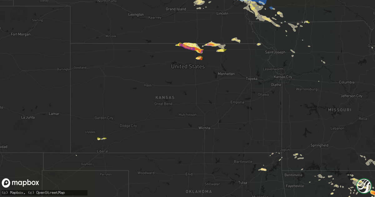
Hail Map in Kansas on June 13, 2026
Get this storm
June 13 map
$229
one time, instant access
Download today. No call, no setup
Keep the $229
Bought the map and want the full workflow? Apply the entire $229 to a subscription within 7 days. None of it is wasted.
Every map, not just this one
This buys you this map. Subscription and you get every map we run, in the markets you choose from a few cities to whole states to nationwide. Plus real-time alerts the moment a storm fires.
Contact data
Name, contact info, occupancy, even credit band for addresses in the footprint. You go from where it hit to who to call.
Become the source they trust
Unlimited branding weather history reports on demand. You already have the documented answer ready for the property owner, and you are the one who showed up with it.
Property data and RoofTrace estimates
Pull up any address you have got, its value and the exact code rules for that jurisdiction, straight from One Click Code. Then RoofTrace estimates the squares, pitch, and roof value, priced the way you price.
Storm reports in Kansas
Kansas
| Date | Description |
|---|---|
| 06/13/20266:59 PM CDT | A local report indicates 1.75 inch wind near 5 E Oxford |
| 06/13/20266:59 PM CDT | Personal weather station. Near leading edge of outflow. |
| 06/13/20266:58 PM CDT | Photo shared over social media... Time estimated from radar. |
| 06/13/20266:58 PM CDT | Shared over social media... Time estimated from radar. |
| 06/13/20266:56 PM CDT | Personal weather station. |
| 06/13/20266:52 PM CDT | A local report indicates 1.50 inch wind near 4 SW Winfield |
| 06/13/20266:50 PM CDT | A local report indicates 2.50 inch wind near 5 ESE Oxford |
| 06/13/20266:50 PM CDT | Personal weather station. |
| 06/13/20266:49 PM CDT | A local report indicates 1.00 inch wind near 6 S Rozel |
| 06/13/20266:44 PM CDT | A local report indicates 1.25 inch wind near 1 NW Geneseo |
| 06/13/20266:43 PM CDT | A local report indicates 2.50 inch wind near Albert |
| 06/13/20266:42 PM CDT | A local report indicates 1.50 inch wind near Albert |
| 06/13/20266:39 PM CDT | A local report indicates 1.00 inch wind near Rozel |
| 06/13/20266:37 PM CDT | Time estimated by radar. |
| 06/13/20266:32 PM CDT | Kwch media report. |
| 06/13/20266:28 PM CDT | A local report indicates 1.00 inch wind near Spearville |
| 06/13/20266:27 PM CDT | Several large trees down. |
| 06/13/20266:27 PM CDT | Along with nickel size hail. |
| 06/13/20266:25 PM CDT | Report made through social media. |
| 06/13/20266:16 PM CDT | Estimated speed of strong wind gusts. |
| 06/13/20266:10 PM CDT | Union pacific observation site. |
| 06/13/20266:08 PM CDT | A local report indicates 60 MPH wind near Frankfort |
| 06/13/20265:45 PM CDT | [landspout] landspout tornado was also visible from the office window of nws dodge city. |
| 06/13/20265:45 PM CDT | Roughly 1.5 hail via a picture on social media. |
| 06/13/20265:39 PM CDT | Along highway 9. |
| 06/13/20265:33 PM CDT | Also with 1 inch hail. |
| 06/13/20265:33 PM CDT | Also 50-60 mph winds. |
| 06/13/20265:32 PM CDT | Sheriffs office relayed report of golf ball size hail on highway 9 west of clyde. Location estimated from radar. |
| 06/13/20265:23 PM CDT | A local report indicates 1.00 inch wind near 4 SSE Bremen |
| 06/13/20265:10 PM CDT | Increased from pea to quarter size hail over 10 minutes. |
| 06/13/20265:07 PM CDT | A local report indicates 1.00 inch wind near 5 S Sublette |
| 06/13/20265:07 PM CDT | A local report indicates 1.00 inch wind near Belleville |
| 06/13/20264:55 PM CDT | Report on spotter network of two inch hail. |
| 06/13/20264:35 PM CDT | Penny to golf ball size hail reported. |
| 06/13/20264:33 PM CDT | Report received via facebook. |
| 06/13/20264:33 PM CDT | A local report indicates 1.25 inch wind near 2 NE Webber |
| 06/13/20264:25 PM CDT | Second round of hail dropped hail up to quarter size...time approximated from report and radar. |
| 06/13/20264:22 PM CDT | A local report indicates 1.00 inch wind near 5 WNW Webber |
| 06/13/20264:09 PM CDT | Hail covered the ground. |
| 06/13/20263:53 PM CDT | A local report indicates 1.00 inch wind near 5 NNW Webber |
| 06/13/20263:45 PM CDT | Report received via facebook. |
| 06/12/202610:46 PM CDT | Asos station kcfv coffeyville municipal airpt. |
| 06/12/202610:40 PM CDT | A local report indicates 70 MPH wind near 2 W Independence Airpor |
| 06/12/202610:39 PM CDT | Multiple reports of power lines down and several reports of trees down per 911 calls. |
| 06/12/202610:39 PM CDT | 8 in. Diameter tree down. |
| 06/12/202610:36 PM CDT | Asos station kcfv coffeyville municipal airpt. |
| 06/12/202610:35 PM CDT | Awos station kidp independence municipal airpt. |
| 06/12/202610:25 PM CDT | Asos station kppf parsons. |
| 06/12/202610:25 PM CDT | A local report indicates 68 MPH wind near 1.4 NNE Independence |
| 06/12/202610:21 PM CDT | Tree down. |
| 06/12/202610:05 PM CDT | Downed wires near 1400th road. Time estimated from radar. |
| 06/12/202610:01 PM CDT | A local report indicates 60 MPH wind near Moran |
| 06/12/202610:00 PM CDT | Corrects previous tstm wnd gst report from 1 w chanute. Kcnu reported 58 mph. |
| 06/12/20269:59 PM CDT | Downed wires near route 7. Time estimated from radar. |
| 06/12/20269:56 PM CDT | Downed wires near medium lake. Time estimated from radar. |
| 06/12/20269:55 PM CDT | Kk88 measured 66 mph. |
| 06/12/20269:55 PM CDT | Tree damage/ trees over road. |
| 06/12/20269:55 PM CDT | A local report indicates 60 MPH wind near 5 N Iola |
| 06/12/20269:45 PM CDT | Photos of several trees down shared from law enforcement. Time estimated from radar. |
| 06/12/20269:45 PM CDT | Multiple power lines down throughout town and no power. |
| 06/12/20269:45 PM CDT | Utility pole sparking from lightning strike with strong winds and heavy rainfall. |
| 06/12/20269:44 PM CDT | A local report indicates 60 MPH wind near Dexter |
| 06/12/20269:40 PM CDT | Large tree down on private property. |
| 06/12/20269:40 PM CDT | Tree damage / tree over gravel road. |
| 06/12/20269:40 PM CDT | Power line down and tree on fire. |
| 06/12/20269:38 PM CDT | Power lines reported down. |
| 06/12/20269:38 PM CDT | Street crews responding to large tree down... Blocking roadway in town. Time estimated from radar. |
| 06/12/20269:35 PM CDT | K13k measured 58 mph. |
| 06/12/20269:33 PM CDT | Asos station kwld strother field airport. |
| 06/12/20269:33 PM CDT | Measured from private weather station. |
| 06/12/20269:32 PM CDT | A local report indicates 71 MPH wind near 2 SW Winfield |
| 06/12/20269:31 PM CDT | Numerous tree branches down. |
| 06/12/20269:30 PM CDT | Power lines down... Shared over social media. |
| 06/12/20269:30 PM CDT | A local report indicates 60 MPH wind near 4 SW Winfield |
| 06/12/20269:30 PM CDT | Power lines reported blown down in the city of garnett. |
| 06/12/20269:29 PM CDT | Estimated 60-70 mph. |
| 06/12/20269:29 PM CDT | A local report indicates 71 MPH wind near 1 N Arkansas City |
| 06/12/20269:16 PM CDT | A local report indicates 67 MPH wind near 6.2 SSE Mayfield |
| 06/12/20269:15 PM CDT | Awos station kukl burlington. |
| 06/12/20269:15 PM CDT | Wellington municipal airport awos. |
| 06/12/20269:13 PM CDT | Delayed report. 8 inch and 15 inch tree limb down. Time estimated from radar. |
| 06/12/20269:05 PM CDT | Lightning strike exploded a transformer on 55th and meridian in haysville... Across from campus high. |
| 06/12/20269:02 PM CDT | Personal weather station measurement. |
| 06/12/20269:02 PM CDT | A local report indicates 60 MPH wind near 5 E Waverly |
| 06/12/20269:00 PM CDT | Shared over social media... Bent/broken railroad crossing arm. |
| 06/12/20269:00 PM CDT | Lots of tree damage. |
| 06/12/20268:56 PM CDT | Asos station kp28 medicine lodge. |
| 06/12/20268:55 PM CDT | Wellington municipal airport. |
| 06/12/20268:53 PM CDT | Asos station kemp emporia. |
| 06/12/20268:49 PM CDT | 60-70 mph wind gusts. |
| 06/12/20268:49 PM CDT | A local report indicates 60 MPH wind near Haysville |
| 06/12/20268:48 PM CDT | Wichita dwight d eisenhower national airport asos. |
| 06/12/20268:47 PM CDT | Measured from pws. |
| 06/12/20268:46 PM CDT | A local report indicates 60 MPH wind near 10 SSW Big Bow |
| 06/12/20268:45 PM CDT | A local report indicates 60 MPH wind near 5 WNW Clearwater |
| 06/12/20268:45 PM CDT | Kansas mesonet station viok1 measured a 10 meter gust of 78 mph with a 2 meter gust of 58 mph. |
| 06/12/20268:43 PM CDT | A local report indicates 75 MPH wind near 1 N Viola |
| 06/12/20268:33 PM CDT | A local report indicates 60 MPH wind near 1 WSW Mission Hills |
| 06/12/20268:32 PM CDT | Private weather sensor. |
| 06/12/20268:32 PM CDT | A local report indicates 59 MPH wind near 2 SSE Overland Park |
| 06/12/20268:31 PM CDT | Multiple downed trees in prairie village. Time estimated from radar. |
| 06/12/20268:30 PM CDT | Large tree limb downed. Time estimated from radar. |
| 06/12/20268:29 PM CDT | Public shared photo of large tree branch down on road. Time estimated from radar. |
| 06/12/20268:29 PM CDT | Power flashes in the area. |
| 06/12/20268:28 PM CDT | Delayed report. Power poles for transmission lines snapped off. Time estimated from radar. |
| 06/12/20268:25 PM CDT | 3 inch tree limbs down. Gusts 60 to 70 mph. |
| 06/12/20268:24 PM CDT | Social media report. Downed tree limb near j.c. Harmon high school. Time estimated from radar. |
| 06/12/20268:22 PM CDT | Mping report of downed tree limbs near quivira lane. Time estimated from radar. |
| 06/12/20268:18 PM CDT | Mping report of downed tree limbs near 114th street. Time estimated from radar. |
| 06/12/20268:16 PM CDT | Tree snapped at a residence in piper. Time estimated from radar. |
| 06/12/20268:15 PM CDT | A local report indicates 58 MPH wind near 2 S Pratt |
| 06/12/20268:14 PM CDT | Private weather sensor. |
| 06/12/20268:14 PM CDT | Several popup tents damaged. Images relayed by em. Time estimated from radar. |
| 06/12/20268:12 PM CDT | Downed tree near 4th street and walnut. Time estimated from radar. |
| 06/12/20268:10 PM CDT | Downed trees throughout leavenworth county. Time estimated from radar. |
| 06/12/20268:07 PM CDT | Awos station k9k8 kingman. |
| 06/12/20268:07 PM CDT | Public relayed photo of tree snapped. Time estimated from radar. |
| 06/12/20268:06 PM CDT | Public relayed video of large tree branches down. Time estimated from radar. |
| 06/12/20268:05 PM CDT | A local report indicates 69 MPH wind near 1 N Lowemont |
| 06/12/20268:02 PM CDT | A local report indicates 81 MPH wind near 3 E Jarbalo |
| 06/12/20268:02 PM CDT | Public relayed photo of large tree branches down. Time estimated from radar. |
| 06/12/20268:00 PM CDT | A picture on social media of roughly 1.25 inch hail. |
| 06/12/20268:00 PM CDT | Delayed report. A few reports of roofs and sheds damaged as well as numerous trees down. Half of the roof of a shed ripped off. Time estimated from radar. |
| 06/12/20268:00 PM CDT | Asos station klwc lawrence. |
| 06/12/20267:57 PM CDT | Emergency manager shared public video of tree falling in northern lawrence. |
| 06/12/20267:56 PM CDT | Corrects previous tstm wnd dmg report from 4 wnw tonganoxie. Large tree down blocking the road near tonganoxie state lake. Time estimated from radar. |
| 06/12/20267:53 PM CDT | 50-60 mph wind estimate. |
| 06/12/20267:51 PM CDT | Estimated 60 mph winds northeast of mclouth. |
| 06/12/20267:49 PM CDT | Tree limb down on power line. |
| 06/12/20267:47 PM CDT | Fire chief estimated 60 to 70 mph winds west of perry. |
| 06/12/20267:45 PM CDT | Debris blown onto the roadway near the intersection of route 73 and green street. Time confirmed from radar. |
| 06/12/20267:43 PM CDT | A local report indicates 67 MPH wind near 1 N Macksville |
| 06/12/20267:39 PM CDT | Time estimated from radar. |
| 06/12/20267:36 PM CDT | Downed tree and wires on kingman road. Time estimated from radar. |
| 06/12/20267:30 PM CDT | Measured on home weather station. |
| 06/12/20267:29 PM CDT | A local report indicates 72 MPH wind near Lancaster |
| 06/12/20267:27 PM CDT | A local report indicates 60 MPH wind near Lancaster |
| 06/12/20267:26 PM CDT | Six inch limb down across highway 24 in silver lake. |
| 06/12/20267:24 PM CDT | A local report indicates 63 MPH wind near 1 N Macksville |
| 06/12/20267:22 PM CDT | Em relayed report from police chief estimating 55 to 60 mph wind gusts. |
| 06/12/20267:20 PM CDT | Downed trees near 286th road and graham road.. Time estimated from radar. |
| 06/12/20267:17 PM CDT | Mping report of downed tree limbs east of arrington. Time confirmed from radar. |
| 06/12/20267:15 PM CDT | Personal weather station. |
| 06/12/20267:11 PM CDT | Salina regional airport asos. |
| 06/12/20267:09 PM CDT | A local report indicates 1.00 inch wind near 2 N Salina |
| 06/12/20267:00 PM CDT | Shared through social media... Time estimated from radar. |
| 06/12/20267:00 PM CDT | A local report indicates 1.00 inch wind near 4 SSW Winfield |
All States Impacted by Hail Map on June 13, 2026
Cities Impacted by Hail Map on June 13, 2026
- Platte Center, NE
- Columbus, NE
- Leigh, NE
- Clarkson, NE
- Wisner, NE
- Pender, NE
- Silver Creek, NE
- Clarks, NE
- Osceola, NE
- Fullerton, NE
- Genoa, NE
- Polk, NE
- Schuyler, NE
- Benedict, NE
- Stromsburg, NE
- Bancroft, NE
- Haskell, OK
- Sloan, IA
- Winnebago, NE
- Salix, IA
- David City, NE
- Linwood, NE
- Walthill, NE
- Rosalie, NE
- Rogers, NE
- Shelby, NE
- Gresham, NE
- Whiting, IA
- York, NE
- Waco, NE
- Dodge, NE
- Ulysses, NE
- Surprise, NE
- Macy, NE
- Morse Bluff, NE
- Abie, NE
- Bellwood, NE
- Hornick, IA
- Cedar Bluffs, NE
- Rising City, NE
- North Bend, NE
- Malmo, NE
- Prague, NE
- Dwight, NE
- Brainard, NE
- Colon, NE
- Mead, NE
- Yutan, NE
- Staplehurst, NE
- Utica, NE
- Fremont, NE
- Ames, NE
- Wahoo, NE
- Weston, NE
- Valley, NE
- Smithland, IA
- La Vista, NE
- Omaha, NE
- Waterloo, NE
- Mapleton, IA
- Oto, IA
- Gretna, NE
- Ashland, NE
- Elkhorn, NE
- Anthon, IA
- Arlington, NE
- Bennington, NE
- Kennard, NE
- Blair, NE
- Fort Calhoun, NE
- Washington, NE
- Offutt Afb, NE
- Bellevue, NE
- Boys Town, NE
- Papillion, NE
- Carter Lake, IA
- Missouri Valley, IA
- Honey Creek, IA
- Crescent, IA
- Council Bluffs, IA
- Underwood, IA
- McClelland, IA
- Glenwood, IA
- Treynor, IA
- Silver City, IA
- Mineola, IA
- Macomb, IL
- Industry, IL
- Pacific Junction, IA
- Murray, NE
- Plattsmouth, NE
- Neola, IA
- Minden, IA
- Macedonia, IA
- Oakland, IA
- Carson, IA
- Henderson, IA
- Adair, IL
- Tabor, IA
- Malvern, IA
- Thurman, IA
- Griswold, IA
- Emerson, IA
- Red Oak, IA
- Elliott, IA
- Randolph, IA
- Farragut, IA
- Sidney, IA
- Riverton, IA
- Hastings, IA
- Imogene, IA
- Shenandoah, IA
- Coin, IA
- Essex, IA
- Northboro, IA
- Blanchard, IA
- Clarinda, IA
- College Springs, IA
- New Market, IA
- Braddyville, IA
- Houstonia, MO
- Sweet Springs, MO
- Gravity, IA
- Villisca, IA
- Nodaway, IA
- Shambaugh, IA
- Clearmont, MO
- Elmo, MO
- Stanton, IA
- Bedford, IA
- Hopkins, MO
- Pickering, MO
- Sharpsburg, IA
- Lenox, IA
- Corning, IA
- Sheridan, MO
- Parnell, MO
- Grant City, MO
- Blockton, IA
- Cameron, MO
- Martinsville, MO
- Denver, MO
- Stanberry, MO
- Gentry, MO
- Berwick, IA
- Ankeny, IA
- Altoona, IA
- Hatfield, MO
- Eagleville, MO
- Albany, MO
- New Hampton, MO
- Bethany, MO
- Cainsville, MO
- Blythedale, MO
- Davis City, IA
- Pattonsburg, MO
- Pomona, MO
- Willow Springs, MO
- Mountain View, MO
- Jameson, MO
- Jamesport, MO
- Gilman City, MO
- Turney, MO
- West Plains, MO
- Chillicothe, MO
- Harrison, AR
- Peace Valley, MO
- Yellville, AR
- Lead Hill, AR
- Alton, MO
- Lachine, MI
- Alpena, MI
- Posen, MI
- Deep River, IA
- Birch Tree, MO
- Victor, IA
- Koshkonong, MO
- Williamsburg, IA
- Millersburg, IA
- North English, IA
- Ladora, IA
- Norfork, AR
- Calico Rock, AR
- Winnabow, NC
- Webster, IA
- Herron, MI
- Dolph, AR
- Elizabeth, AR
- Parnell, IA
- Mountain Home, AR
- Wilmington, NC
- Hubbard Lake, MI
- Ossineke, MI
- Henderson, AR
- Couch, MO
- Bexar, AR
- Wideman, AR
- Triplett, MO
- Doniphan, MO
- Brunswick, MO
- Gatewood, MO
- Warm Springs, AR
- Myrtle, MO
- Norfolk, NE
- Oxford, AR
- Gepp, AR
- Pineville, AR
- Salem, AR
- Brockwell, AR
- Pocahontas, AR
- Maynard, AR
- Horseshoe Bend, AR
- Wiseman, AR
- Violet Hill, AR
- Hampstead, NC
- Rocky Point, NC
- Oran, MO
- Vanduser, MO
- Bell City, MO
- Melbourne, AR
- Sage, AR
- Franklin, AR
- Homer, NE
- Essex, MO
- Sikeston, MO
- Paragould, AR
- Okeechobee, FL
- Ravenden Springs, AR
- Decatur, MS
- Moville, IA
- Climbing Hill, IA
- Evening Shade, AR
- Imboden, AR
- Marmaduke, AR
- Rector, AR
- Alpena, AR
- Sidney, AR
- Mount Pleasant, AR
- Guion, AR
- Beemer, NE
- Delaplaine, AR
- Charleston, MO
- Seligman, MO
- Waverly, GA
- Quincy, IL
- Biggers, AR
- Oakland, TN
- Somerville, TN
- Cave City, AR
- Everton, AR
- Chipley, FL
- Panama City, FL
- Beech Grove, AR
- Longs, SC
- Aurora, NC
- Sulphur Rock, AR
- Valley Springs, AR
- Craig, NE
- Poughkeepsie, AR
- Hayti, MO
- Bragg City, MO
- Townsend, GA
- Lumber Bridge, NC
- Saint Pauls, NC
- Providence, KY
- Bristol, GA
- Mershon, GA
- Screven, GA
- Wewahitchka, FL
- Saint Joe, AR
- Lafe, AR
- Decatur, NE
- Pollocksville, NC
- Trenton, NC
- New Bern, NC
- Blytheville, AR
- Cord, AR
- Tekamah, NE
- Blencoe, IA
- Bardwell, KY
- Corinth, MS
- Parkton, NC
- Nebo, KY
- Strawberry, AR
- Smithville, AR
- Jonesboro, AR
- Charlotte, AR
- Batesville, AR
- Marston, MO
- Bronson, IA
- Manitou, KY
- Madisonville, KY
- Bay, AR
- Arlington, KY
- Obion, TN
- Tiptonville, TN
- Hickman, KY
- Newark, AR
- Saffell, AR
- Tuckerman, AR
- Burr Oak, KS
- Jacksonville, FL
- Harriet, AR
- Bryceville, FL
- Saint George, GA
- Steele, MO
- Caruthersville, MO
- Williams, AZ
- Mankato, KS
- Green Forest, AR
- Webber, KS
- Superior, NE
- Fancy Farm, KY
- Maysville, NC
- White Oak, NC
- Harrisburg, AR
- Weiner, AR
- Hilliard, FL
- Omaha, AR
- Cardwell, MO
- Newport, AR
- Swifton, AR
- Ridgely, TN
- Newbern, TN
- Conway, SC
- Hanson, KY
- Courtland, KS
- Hardy, NE
- Republic, KS
- Goodwell, OK
- Trimble, TN
- Mountain View, AR
- Manila, AR
- Marshall, AR
- Purdy, MO
- Kenton, TN
- Dover, AR
- London, AR
- Knoxville, AR
- Lamar, AR
- Mahaska, KS
- Fifty Six, AR
- Ravenden, AR
- Shirley, AR
- Granby, MO
- Stark City, MO
- Gainesville, AL
- Garland, NC
- Timbo, AR
- Pamplico, SC
- Narka, KS
- Fairbury, NE
- Morrowville, KS
- Moscow, KS
- Satanta, KS
- Epes, AL
- Fox, AR
- Edgemont, AR
- Ripley, TN
- Pierce City, MO
- Dyess, AR
- Osceola, AR
- Etowah, AR
- Lepanto, AR
- Fairview, MO
- Monett, MO
- Wyandotte, OK
- Belleville, KS
- Hollenberg, KS
- Endicott, NE
- Steele City, NE
- Dyer, TN
- Byron, NE
- Burchard, NE
- Prim, AR
- Dyersburg, TN
- Greenfield, TN
- Sharon, TN
- Rutherford, TN
- Wentworth, MO
- Marked Tree, AR
- Henning, TN
- Whiteville, NC
- Bradford, TN
- Sacramento, KY
- Huntsville, AR
- Washington, KS
- Scandia, KS
- Pawnee City, NE
- Big Cabin, OK
- Century, FL
- Seneca, MO
- Friendship, TN
- Quitman, GA
- Adair, OK
- Trenton, TN
- Fairfield Bay, AR
- Wilson, AR
- Joiner, AR
- Chelsea, OK
- Hanover, KS
- Barnes, KS
- McCrory, AR
- Bremen, KS
- Marysville, KS
- Waterville, KS
- McKenzie, TN
- Munden, KS
- Cuba, KS
- Arcadia, FL
- Higden, AR
- Drasco, AR
- Welch, OK
- Pantego, NC
- Vinita, OK
- Bee Branch, AR
- Gleason, TN
- Clinton, AR
- Diller, NE
- Frenchmans Bayou, AR
- Hiawatha, KS
- Zolfo Springs, FL
- Agenda, KS
- Concordia, KS
- Sublette, KS
- Milan, TN
- Steinauer, NE
- Du Bois, NE
- White Cloud, KS
- Quitman, AR
- Oketo, KS
- Quapaw, OK
- Clyde, KS
- Baxter Springs, KS
- Tumbling Shoals, AR
- Ida, AR
- Miami, OK
- Pinetown, NC
- Huntingdon, TN
- Drummonds, TN
- Turrell, AR
- Heber Springs, AR
- Haddam, KS
- Jetmore, KS
- Clifton, KS
- Aurora, KS
- Millington, TN
- Parsons, TN
- Linden, TN
- Keyes, OK
- Rush Center, KS
- Fort McCoy, FL
- Bern, KS
- Seneca, KS
- Home, KS
- Linn, KS
- Beattie, KS
- Williston, TN
- Wynne, AR
- Rulo, NE
- Sumner, GA
- Ashburn, GA
- Greenleaf, KS
- Palmer, KS
- Frankfort, KS
- Morganville, KS
- Ellsworth, KS
- Lorraine, KS
- Medford, OK
- Rozel, KS
- Fitzgerald, GA
- Galena, KS
- Georgetown, SC
- Hanston, KS
- Exeter, MO
- Rocky Comfort, MO
- Burdett, KS
- Humboldt, NE
- Fairfax, MO
- Deer, AR
- Sugar Tree, TN
- Braman, OK
- Eucha, OK
- Larned, KS
- Randolph, KS
- Blue Rapids, KS
- Green, KS
- Spearville, KS
- Skidmore, MO
- Deer Creek, OK
- Pawnee Rock, KS
- Great Bend, KS
- Liberal, KS
- Wakita, OK
- Kinsley, KS
- Holladay, TN
- Burlington Junction, MO
- Maryville, MO
- Proctor, AR
- Clay Center, KS
- Afton, OK
- Kanopolis, KS
- South Haven, KS
- Caldwell, KS
- Nardin, OK
- Otis, KS
- Cedarcreek, MO
- Geneseo, KS
- Crawfordsville, AR
- Canadian, TX
- Vermillion, KS
- Kirbyville, MO
- West Memphis, AR
- Edmondson, AR
- Leonardville, KS
- Hagarville, AR
- Jay, OK
- Brookville, KS
- Worth, MO
- Manhattan, KS
- Westmoreland, KS
- Olsburg, KS
- Arkansas City, KS
- Geuda Springs, KS
- Oxford, KS
- Winfield, KS
- Albert, KS
- Olmitz, KS
- Wright, KS
- Dodge City, KS
- Ford, KS
- Lobelville, TN
- Riley, KS
- Blackwell, OK
- Lake Cormorant, MS
- Sabetha, KS
- Oneida, KS
- Marion, AR
- Grove, OK
- Wakefield, KS
- Offerle, KS
- Maitland, MO
- Mound City, MO
- Udall, KS
- Powhattan, KS
- Axtell, KS
- Fairview, KS
- Wetmore, KS
- Whiting, KS
- Baileyville, KS
- Netawaka, KS
- Centralia, KS
- Holton, KS
- Summerfield, KS
- Circleville, KS
- Horton, KS
- Corning, KS
- Goff, KS
- Onaga, KS
- Salina, KS
- Marianna, AR
- Havensville, KS
- Soldier, KS
- Centerville, TN
- New Cambria, KS
- Solomon, KS
- Walls, MS
- Grayville, IL
- Little River, KS
- Ellinwood, KS
- Claflin, KS
- Grand Junction, TN
- Moscow, TN
- Lamont, OK
- Bushton, KS
- Effingham, KS
- Muscotah, KS
- Ravenwood, MO
- Wamego, KS
- Saint George, KS
- Mayetta, KS
- Belvue, KS
- Saint Marys, KS
- Delia, KS
- Emmett, KS
- Lyons, KS
- Garfield, KS
- Bucklin, KS
- Hoyt, KS
- Valley Falls, KS
- Denison, KS
- Everest, KS
- Lancaster, KS
- Rossville, KS
- Paxico, KS
- Alma, KS
- Junction City, KS
- Ogden, KS
- Fort Riley, KS
- Milford, KS
- Sanford, FL
- Hughes, AR
- Ponca City, OK
- Fairland, OK
- Miami, TX
- Hohenwald, TN
- Minneola, KS
- Belpre, KS
- Hoisington, KS
- Hickory Valley, TN
- Bluejacket, OK
- Geneseo, IL
- Assaria, KS
- Gypsum, KS
- Macksville, KS
- St John, KS
- Burden, KS
- Rock, KS
- Chase, KS
- Corona, NM
- Stratford, TX
- Pratt, KS
- Atlanta, KS
- Deltona, FL
- Maysville, AR
- Gravette, AR
- Abilene, KS
- Saulsbury, TN
- Atchison, KS
- Cummings, KS
- Nortonville, KS
- Topeka, KS
- Silver Lake, KS
- Meriden, KS
- Maple Hill, KS
- Oskaloosa, KS
- Ozawkie, KS
- Grantville, KS
- Perry, KS
- Winchester, KS
- Tecumseh, KS
- Council Grove, KS
- Alta Vista, KS
- Dwight, KS
- White City, KS
- McFarland, KS
- Byers, KS
- Tonkawa, OK
- Douglass, KS
- Enterprise, KS
- Lewis, KS
- Weed, NM
- Hampshire, TN
- Gentry, AR
- Colcord, OK
- Decatur, AR
- Turon, KS
- Cunningham, KS
- Lakeland, FL
- Walnut, MS
- Latham, KS
- Iuka, KS
- Pretty Prairie, KS
- Arlington, KS
- Kingman, KS
- Stafford, KS
- Raymond, KS
- Spearman, TX
- Manter, KS
- Higgins, TX
- Mount Pleasant, TN
- Eskridge, KS
- Johnson, KS
- Richfield, KS
- Walsh, CO
- McLouth, KS
- Leavenworth, KS
- Rushville, MO
- Linwood, KS
- Lecompton, KS
- Berryton, KS
- Lawrence, KS
- Weston, MO
- Tonganoxie, KS
- De Kalb, MO
- Platte City, MO
- Baldwin City, KS
- Fort Leavenworth, KS
- Easton, KS
- Harveyville, KS
- Allen, KS
- Wilsey, KS
- Amarillo, TX
- Marland, OK
- Hunter, OK
- Lost Springs, KS
- Ramona, KS
- Tampa, KS
- Rose Hill, KS
- Haviland, KS
- Pinon, NM
- Belle Plaine, KS
- Masterson, TX
- Augusta, KS
- Lansing, KS
- Lenexa, KS
- Basehor, KS
- Kansas City, MO
- Farley, MO
- Bonner Springs, KS
- Shawnee, KS
- Kansas City, KS
- De Soto, KS
- Eudora, KS
- Waldron, MO
- Cloudcroft, NM
- Camden Point, MO
- Olathe, KS
- Riverside, MO
- Edgerton, KS
- New Century, KS
- Gardner, KS
- Overland Park, KS
- Mission, KS
- Wellsville, KS
- Burlingame, KS
- Auburn, KS
- Reading, KS
- Scranton, KS
- Admire, KS
- Osage City, KS
- Emporia, KS
- Americus, KS
- Severy, KS
- Piedmont, KS
- Howard, KS
- Nashville, KS
- Murdock, KS
- Spivey, KS
- Harper, KS
- Milton, KS
- Zenda, KS
- Cheney, KS
- Garden Plain, KS
- Norwich, KS
- Ralston, OK
- Fairfax, OK
- Red Rock, OK
- Pawnee, OK
- Durham, OK
- Keosauqua, IA
- Columbus, KS
- Viola, KS
- Goddard, KS
- Lincolnville, KS
- Tunica, MS
- Clearwater, KS
- Wichita, KS
- Leon, KS
- Sawyer, KS
- Mulvane, KS
- Bentonville, AR
- Conway Springs, KS
- Argonia, KS
- Danville, KS
- Colwich, KS
- Milan, KS
- Andale, KS
- Scammon, KS
- Cedar Point, KS
- Florence, KS
- Wellington, KS
- Isabel, KS
- Medicine Lodge, KS
- Strong City, KS
- Elmdale, KS
- Springdale, AR
- Fayetteville, AR
- Burns, KS
- Peabody, KS
- Newton, KS
- Vega, TX
- Fall River, KS
- Toronto, KS
- Yates Center, KS
- Waverly, KS
- Parsons, KS
- McCune, KS
- Smithville, MO
- Kearney, MO
- Edgerton, MO
- Liberty, MO
- Independence, MO
- Prairie Village, KS
- Leawood, KS
- Stilwell, KS
- Cleveland, MO
- Spring Hill, KS
- Peculiar, MO
- Grandview, MO
- Raymore, MO
- Belton, MO
- Bucyrus, KS
- Lees Summit, MO
- Lyndon, KS
- Lebo, KS
- Olpe, KS
- Neosho Rapids, KS
- Missouri City, MO
- Greenwood, MO
- Pleasant Hill, MO
- Blue Springs, MO
- Vassar, KS
- Quenemo, KS
- Melvern, KS
- Overbrook, KS
- Hartford, KS
- Attica, KS
- Perryton, TX
- Haysville, KS
- Erie, KS
- Kim, CO
- Cottonwood Falls, KS
- Westphalia, KS
- Witts Springs, AR
- Sharon, KS
- Weir, KS
- Derby, KS
- Holt, MO
- Excelsior Springs, MO
- Orrick, MO
- Grain Valley, MO
- Buckner, MO
- Sibley, MO
- Oak Grove, MO
- Harrisonville, MO
- Wynona, OK
- Hominy, OK
- Cleveland, OK
- Osage, OK
- Richmond, KS
- Le Roy, KS
- Welda, KS
- Ottawa, KS
- Pomona, KS
- Garnett, KS
- Colony, KS
- Burlington, KS
- Princeton, KS
- Williamsburg, KS
- Peck, KS
- Mayfield, KS
- Mcconnell Afb, KS
- Ulysses, KS
- Hereford, TX
- Las Animas, CO
- Roswell, NM
- Galesburg, KS
- El Dorado, KS
- Eureka, KS
- Matfield Green, KS
- Hamilton, KS
- Wellington, MO
- Napoleon, MO
- Lone Jack, MO
- Kingsville, MO
- Bates City, MO
- Richmond, MO
- Strasburg, MO
- Garden City, MO
- Camden, MO
- Levasy, MO
- Newkirk, OK
- Saint Paul, KS
- Cherokee, KS
- Pritchett, CO
- Stark, KS
- Pittsburg, KS
- Rosalia, KS
- Cassoday, KS
- Odessa, MO
- Lexington, MO
- Mayview, MO
- Holden, MO
- Centerview, MO
- Henrietta, MO
- Cambridge, KS
- Barnsdall, OK
- Skiatook, OK
- Prue, OK
- Wildorado, TX
- Benedict, KS
- Red Bay, AL
- Hazelton, KS
- Waldron, KS
- Freedom, OK
- Walnut, KS
- Girard, KS
- Chanute, KS
- Gridley, KS
- Wilmore, KS
- Coldwater, KS
- Humboldt, KS
- Garber, OK
- Maple City, KS
- Sedan, KS
- Cedar Vale, KS
- Billings, OK
- Shidler, OK
- Grenola, KS
- Pond Creek, OK
- Dexter, KS
- Moline, KS
- Kaw City, OK
- Mound City, KS
- Blue Mound, KS
- Fort Scott, KS
- Fulton, KS
- Greeley, KS
- Mapleton, KS
- Kincaid, KS
- Centerville, KS
- Prescott, KS
- Neal, KS
- Elsmore, KS
- Madison, KS
- La Harpe, KS
- Virgil, KS
- Piqua, KS
- Buffalo, KS
- Longton, KS
- Uniontown, KS
- Iola, KS
- Moran, KS
- Savonburg, KS
- Redfield, KS
- Neosho Falls, KS
- Beaumont, KS
- Bronson, KS
- Fredonia, KS
- Whiteman Air Force Base, MO
- Warrensburg, MO
- Blackburn, MO
- Corder, MO
- Windsor, MO
- La Monte, MO
- Marshall, MO
- Alma, MO
- Higginsville, MO
- Knob Noster, MO
- Chilhowee, MO
- Concordia, MO
- Leeton, MO
- Panhandle, TX
- Hughesville, MO
- Nelson, MO
- Smithton, MO
- Sedalia, MO
- Green Ridge, MO
- Thayer, KS
- Altoona, KS
- Neodesha, KS
- Liberty, KS
- Deerfield, MO
- Dennis, KS
- Hepler, KS
- Farlington, KS
- Elk City, KS
- Cherryvale, KS
- Independence, KS
- Elk Falls, KS
- Richards, MO
- Perry, OK
- Morrison, OK
- Burbank, OK
- Pawhuska, OK
- Lake City, KS
- Russellville, AL
- Anthony, KS
- Amorita, OK
- Manchester, OK
- Opolis, KS
- Asbury, MO
- Alva, OK
- Wayland, MO
- Kahoka, MO
- Glennie, MI
- Mikado, MI
- Harrisville, MI
- West Mineral, KS
- Mindenmines, MO
- Oronogo, MO
- Burlington, OK
- Cherokee, OK
- Jet, OK
- Argyle, IA
- Farmington, IA
- Franklin, KS
- Altamont, KS
- Edna, KS
- Chetopa, KS
- Arma, KS
- Oswego, KS
- Moundville, MO
- Arcadia, KS
- Mulberry, KS
- Liberal, MO
- Lamar, MO
- Coffeyville, KS
- Frontenac, KS
- Bronaugh, MO
- Mound Valley, KS
- Bartlett, KS
- Garland, KS
- Carl Junction, MO
- Tipton, MO
- Otterville, MO
- Prairie Home, MO
- Syracuse, MO
- California, MO
- Boonville, MO
- Franklin, MO
- Blackwater, MO
- Florence, MO
- Bunceton, MO
- Jamestown, MO
- Clarksburg, MO
- Wooldridge, MO
- Pilot Grove, MO
- Sperry, OK
- Terlton, OK
- Maramec, OK
- Mannford, OK
- Jennings, OK
- Tulsa, OK
- Sand Springs, OK
- S Coffeyville, OK
- Caney, KS
- Havana, KS
- Tyro, KS
- Wann, OK
- Lenapah, OK
- Dearing, KS
- Delaware, OK
- Riverton, KS
- Joplin, MO
- Webb City, MO
- Treece, KS
- Picher, OK
- Commerce, OK
- North Miami, OK
- Cushing, OK
- Yale, OK
- Glencoe, OK
- Stillwater, OK
- Ripley, OK
- Drumright, OK
- Bristow, OK
- Nash, OK
- Westmont, IL
- Glen Ellyn, IL
- Wheaton, IL
- Oak Brook, IL
- Lombard, IL
- Downers Grove, IL
- Wheaton, MO
- Verona, MO
- Golden City, MO
- Goodman, MO
- Pineville, MO
- Stotts City, MO
- Reeds, MO
- Stella, MO
- Mount Vernon, MO
- Miller, MO
- Diamond, MO
- Powell, MO
- Carterville, MO
- Purcell, MO
- Neck City, MO
- La Russell, MO
- Neosho, MO
- Anderson, MO
- Alba, MO
- Sarcoxie, MO
- Avilla, MO
- Carthage, MO
- Freistatt, MO
- Duenweg, MO
- Jasper, MO
- Clarendon Hills, IL
- Darien, IL
- Hinsdale, IL
- Willowbrook, IL
- Lisle, IL
- Villa Park, IL
- Farwell, TX
- Strang, OK
- Richland, MO
- Perkins, OK
- Washburn, MO
- Golden, MO
- Sulphur Springs, AR
- Garfield, AR
- Crane, MO
- Watts, OK
- Bella Vista, AR
- Reeds Spring, MO
- Eagle Rock, MO
- Pea Ridge, AR
- Kimberling City, MO
- Aurora, MO
- Cassville, MO
- Cape Fair, MO
- Eureka Springs, AR
- Hiwasse, AR
- Shell Knob, MO
- Butterfield, MO
- South West City, MO
- Ketchum, OK
- Noel, MO
- Siloam Springs, AR
- Centerton, AR
- Rogers, AR
- Kansas, OK
- Lanagan, MO
- Spavinaw, OK
- Galena, MO
- Claremore, OK
- Nowata, OK
- Tiff City, MO
- Oak Grove, AR
- Blue Eye, MO
- Cave Springs, AR
- Lowell, AR
- Lampe, MO
- Berryville, AR
- Ithaca, MI
- Pryor, OK
- Rogers, NM
- Hindsville, AR
- Lincoln, AR
- Elkins, AR
- Summers, AR
- Prairie Grove, AR
- Farmington, AR
- Causey, NM
- Fort Gibson, OK
- Ionia, MI
- Ash Flat, AR
- Lockwood, MO
- Nevada, MO
- Sheldon, MO
- Nixa, MO
- Jerico Springs, MO
- Forsyth, MO
- Bradleyville, MO
- Noble, MO
- Halltown, MO
- Ash Grove, MO
- Taneyville, MO
- Billings, MO
- Bruner, MO
- Ozark, MO
- Brookline, MO
- Ava, MO
- Dadeville, MO
- Milo, MO
- Thornfield, MO
- Arcola, MO
- South Greenfield, MO
- Sparta, MO
- Clever, MO
- Chadwick, MO
- Walnut Grove, MO
- Chestnutridge, MO
- Everton, MO
- Garrison, MO
- Rogersville, MO
- Wasola, MO
- Squires, MO
- Greenfield, MO
- Republic, MO
- Stockton, MO
- Springfield, MO
- Oldfield, MO
- Marionville, MO
- Fordland, MO
- Norwood, MO
- Highlandville, MO
- Spokane, MO
- Seymour, MO
- Willard, MO
- Bois D Arc, MO
- Depew, OK


