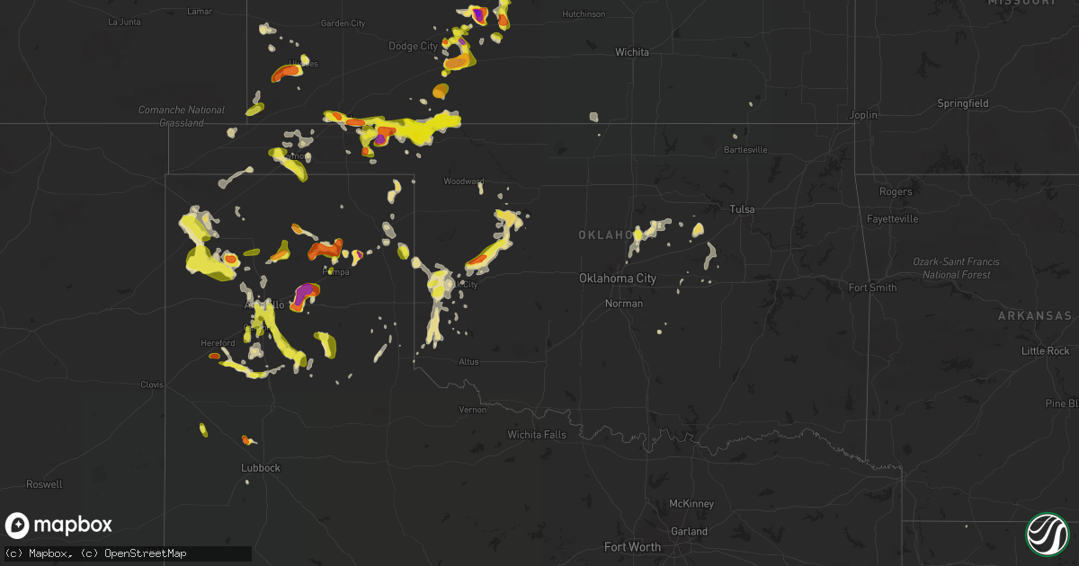
Hail Map in Oklahoma on June 12, 2018
Get this storm
June 12 map
$229
one time, instant access
Download today. No call, no setup
Keep the $229
Bought the map and want the full workflow? Apply the entire $229 to a subscription within 7 days. None of it is wasted.
Every map, not just this one
This buys you this map. Subscription and you get every map we run, in the markets you choose from a few cities to whole states to nationwide. Plus real-time alerts the moment a storm fires.
Contact data
Name, contact info, occupancy, even credit band for addresses in the footprint. You go from where it hit to who to call.
Become the source they trust
Unlimited branding weather history reports on demand. You already have the documented answer ready for the property owner, and you are the one who showed up with it.
Property data and RoofTrace estimates
Pull up any address you have got, its value and the exact code rules for that jurisdiction, straight from One Click Code. Then RoofTrace estimates the squares, pitch, and roof value, priced the way you price.
Storm reports in Oklahoma
Oklahoma
| Date | Description |
|---|---|
| 06/12/20186:44 PM CDT | A local report indicates 1.25 inch wind near 11 N BUFFALO |
| 06/12/20187:26 AM CDT | At 1226 PM CDT, a severe thunderstorm was located 4 miles south of Asher, moving south at 20 mph. HAZARD...Ping pong ball size hail and 60 mph wind gusts. SOURCE...Radar indicated. IMPACT...People and animals outdoors will be injured. Expect hail damage to roofs, siding, windows, and vehicles. Expect wind damage to roofs, siding, and trees. Locations impacted include... Stratford, Asher, Wanette, Byars and Vanoss. |
| 06/12/20187:07 AM CDT | At 1207 PM CDT, a severe thunderstorm was located over southeastern Norman, or near Lake Thunderbird, moving southeast at 20 mph. HAZARD...60 mph wind gusts. SOURCE...Radar indicated. IMPACT...Expect damage to roofs, siding, and trees. Locations impacted include... Southeastern Norman, Pink, Tribbey, Etowah, Macomb, southeastern Lake Thunderbird and Little Axe. |
| 06/12/20186:45 AM CDT | At 1145 PM CDT, a severe thunderstorm was located near Seiling, moving southeast at 20 mph. HAZARD...Ping pong ball size hail and 60 mph wind gusts. SOURCE...Radar indicated. IMPACT...People and animals outdoors will be injured. Expect hail damage to roofs, siding, windows, and vehicles. Expect wind damage to roofs, siding, and trees. Locations impacted include... Taloga, Seiling, Oakwood, Putnam, Fay and Hucmac. |
| 06/12/20186:11 AM CDT | At 1111 PM CDT, a severe thunderstorm was located 4 miles north of Lipscomb, moving southeast at 25 mph. HAZARD...60 mph wind gusts and quarter size hail. SOURCE...Radar indicated. IMPACT...Minor damage to roofs, siding, and trees is possible. Hail damage to vehicles is expected. Locations impacted include... Lipscomb and Higgins. |
| 06/12/20184:49 AM CDT | At 948 PM CDT, severe thunderstorms were located along a line extending from 4 miles south of Griggs to 11 miles east of Dalhart to 17 miles southeast of Romero, moving east at 35 mph. HAZARD...Tennis ball size hail and 60 mph wind gusts. SOURCE...Radar indicated. IMPACT...Minor damage to roofs, siding, and trees is possible. People and animals outdoors will be injured. Expect hail damage to roofs, siding, windows, and vehicles. Locations impacted include... Dumas, Guymon, Dalhart, Stratford, Hartley, Cactus, Sunray, Goodwell, Channing, Optima, Valley De Oro, Boys Ranch, Griggs, Eva, Four Way, Conlen, Masterson and Texhoma. |
| 06/12/20184:43 AM CDT | At 943 AM CDT, a severe thunderstorm was located near Meridian, moving south at 20 mph. HAZARD...Quarter size hail. SOURCE...Radar indicated. IMPACT...Damage to vehicles is expected. Locations impacted include... Meridian and Fallis. |
| 06/12/20184:41 AM CDT | At 940 PM CDT, a severe thunderstorm was located 4 miles southwest of Beaver, moving south at 10 mph. HAZARD...60 mph wind gusts and quarter size hail. SOURCE...Radar indicated. IMPACT...Minor damage to roofs, siding, and trees is possible. Hail damage to vehicles is expected. Locations impacted include... Beaver, Elmwood, Boyd, Mocane, Turpin, Floris and Balko. |
| 06/12/20184:32 AM CDT | At 932 PM CDT, a severe thunderstorm was located 6 miles southeast of Woods, moving east at 5 mph. HAZARD...60 mph wind gusts and half dollar size hail. SOURCE...Radar indicated. IMPACT...Hail damage to vehicles is expected. Expect wind damage to roofs, siding, and trees. Locations impacted include... Liberal, Woods and Hayne. |
| 06/12/20184:10 AM CDT | At 909 PM CDT, a severe thunderstorm was located 11 miles northwest of Elkhart, moving northeast at 15 mph. HAZARD...60 mph wind gusts and half dollar size hail. SOURCE...Radar indicated. IMPACT...Hail damage to vehicles is expected. Expect wind damage to roofs, siding, and trees. Locations impacted include... Elkhart, Richfield and Wilburton. |
| 06/12/20183:29 AM CDT | At 828 PM CDT, a severe thunderstorm was located over Knowles, or 13 miles southwest of Englewood, moving southwest at 5 mph. HAZARD...Ping pong ball size hail and 60 mph wind gusts. SOURCE...Radar indicated. IMPACT...Minor damage to roofs, siding, and trees is possible. People and animals outdoors will be injured. Expect hail damage to roofs, siding, windows, and vehicles. Locations impacted include... Beaver, Forgan, Gate, Knowles and Mocane. |
| 06/12/20183:24 AM CDT | At 823 PM CDT, a nearly stationary line of severe thunderstorms was located from near Liberal to Englewood. HAZARD...60 mph wind gusts and quarter size hail. SOURCE...Radar indicated. IMPACT...Hail damage to vehicles is expected. Expect wind damage to roofs, siding, and trees. Locations impacted include... Liberal, Englewood and Hayne. |
| 06/12/20182:15 AM CDT | At 715 PM CDT, a severe thunderstorm was located near Rosston, moving south at 15 mph. This is a very dangerous storm. HAZARD...80 mph wind gusts and two inch hail. SOURCE...Radar indicated. IMPACT...Flying debris will be dangerous to those caught without shelter. Mobile homes will be heavily damaged. Expect considerable damage to roofs, windows, and vehicles. Extensive tree damage and power outages are likely. Locations impacted include... Laverne, May and Rosston. |
| 06/12/20182:10 AM CDT | At 710 AM CDT, severe thunderstorms were located along a line extending from 6 miles southeast of Brushy to 5 miles northeast of Roland to near Natural Dam, moving south at 40 mph. HAZARD...60 mph wind gusts. SOURCE...Radar indicated. IMPACT...Expect damage to roofs, siding, and trees. Locations in or near the path include... Fort Smith... Van Buren... Poteau... Cedarville... Natural Dam... Greenwood... Alma... Barling... Pocola... Muldrow... Roland... Lavaca... Spiro... Arkoma... Mansfield... Hackett... Howe... Hartford... Huntington... Bonanza...This includes the following highways, Interstate 40 in Arkansas between mile markers 0 and 14. Interstate 40 in Oklahoma between mile markers 316 and 328. Interstate 540 between mile markers 1 and 14. Interstate 49 between mile markers 22 and 25. |
| 06/12/20182:09 AM CDT | At 709 PM CDT, a severe thunderstorm was located 6 miles northeast of Gate, or 8 miles south of Englewood, moving southwest at 10 mph. HAZARD...60 mph wind gusts and half dollar size hail. SOURCE...Radar indicated. IMPACT...Minor damage to roofs, siding, and trees is possible. Hail damage to vehicles is expected. Locations impacted include... Gate, Knowles and Slapout. |
| 06/12/20182:02 AM CDT | At 702 AM CDT, a severe thunderstorm was located 6 miles northeast of Ripley, moving south at 25 mph. HAZARD...Ping pong ball size hail and 60 mph wind gusts. SOURCE...Radar indicated. IMPACT...People and animals outdoors will be injured. Expect hail damage to roofs, siding, windows, and vehicles. Expect wind damage to roofs, siding, and trees. Locations impacted include... Cushing, Perkins, Stroud, Yale, Tryon, Ripley, Agra, Kendrick, Avery, Ingalls and Parkland.This includes Interstate 44 between mile markers 180 and 182. |
| 06/12/20181:35 AM CDT | A local report indicates 79 MPH wind near 5 SW BUTLER |
| 06/12/20181:29 AM CDT | At 629 AM CDT, severe thunderstorms were located along a line extending from 7 miles southeast of Glencoe to 2 miles west of Keystone State Park, moving southwest at 25 mph. HAZARD...60 mph wind gusts and nickel size hail. SOURCE...Radar indicated. IMPACT...Expect damage to roofs, siding, and trees. Locations in or near the path include... Sand Springs... Bristow... Sapulpa... Mannford... Drumright... Kellyville... Oilton... Depew... Jennings... Slick... Terlton... Shamrock... Keystone State Park... Silver City...This includes Interstate 44 between mile markers 178 and 213. |
| 06/12/20181:16 AM CDT | At 616 AM CDT, a severe thunderstorm was located near Maramec, moving south at 20 mph. HAZARD...Ping pong ball size hail and 60 mph wind gusts. SOURCE...Radar indicated. IMPACT...People and animals outdoors will be injured. Expect hail damage to roofs, siding, windows, and vehicles. Expect wind damage to roofs, siding, and trees. Locations impacted include... Cushing, Yale and Quay. |
| 06/12/201812:41 AM CDT | At 540 AM CDT, severe thunderstorms were located along a line extending from 4 miles south of Avant to 5 miles northeast of Skedee, moving southwest at 35 mph. HAZARD...60 mph wind gusts and half dollar size hail. SOURCE...Radar indicated. IMPACT...Hail damage to vehicles is expected. Expect wind damage to roofs, siding, and trees. Locations in or near the path include... Sand Springs... Pawnee... Skiatook... Hominy... Cleveland... Mannford... Drumright... Oilton... Jennings... Westport... Osage... Hallett... Blackburn... Terlton... Maramec... Skedee... Keystone State Park... Walnut Creek State Park... Silver City... This includes Interstate 44 between mile markers 205 and 207. |
| 06/12/201812:31 AM CDT | At 530 PM CDT, a severe thunderstorm was located 10 miles southeast of Sitka, moving southwest at 5 mph. HAZARD...60 mph wind gusts and half dollar size hail. SOURCE...Radar indicated. IMPACT...Hail damage to vehicles is expected. Expect wind damage to roofs, siding, and trees. This severe thunderstorm will remain over mainly rural areas of southwestern Comanche and southeastern Clark Counties. |
| 06/12/201812:05 AM CDT | At 504 AM CDT, severe thunderstorms were located along a line extending from near Avant to 8 miles southwest of Pearsonia, moving southwest at 50 mph. HAZARD...70 mph wind gusts and half dollar size hail. SOURCE...Radar indicated. IMPACT...Hail damage to vehicles is expected. Expect considerable tree damage. Wind damage is also likely to mobile homes, roofs, and outbuildings. Locations in or near the path include... Tulsa... Sand Springs... Pawhuska... Pawnee... Jenks... Skiatook... Hominy... Cleveland... Mannford... Fairfax... Barnsdall... Sperry... Wynona... Jennings... Ralston... Avant... Westport... Osage... Hallett... Blackburn...This includes Interstate 44 between mile markers 212 and 222. |
| 06/11/201811:48 PM CDT | At 446 AM CDT, severe thunderstorms were located along a line extending from near Cleora to 2 miles west of Vera, moving south at 45 mph. HAZARD...70 mph wind gusts and nickel size hail. SOURCE...Radar indicated. IMPACT...Expect considerable tree damage. Damage is likely to mobile homes, roofs, and outbuildings. Locations in or near the path include... Tulsa... Broken Arrow... Claremore... Pryor... Owasso... Bixby... Jenks... Coweta... Pryor Creek... Skiatook... Catoosa... Collinsville... Verdigris... Chouteau... Chelsea... Inola... Locust Grove... Salina... Sperry... Oologah...This includes Interstate 44 between mile markers 222 and 283. |
| 06/11/201811:21 PM CDT | At 421 AM CDT, severe thunderstorms were located along a line extending from 2 miles southwest of Welch to 2 miles southeast of Bartlesville, moving south at 45 mph. HAZARD...70 mph wind gusts and nickel size hail. SOURCE...Radar indicated. IMPACT...Expect considerable tree damage. Damage is likely to mobile homes, roofs, and outbuildings. Locations in or near the path include... Bartlesville... Vinita... Nowata... Dewey... Chelsea... Oologah... Langley... Adair... Welch... Ramona... Ketchum... Ochelata... Delaware... Foyil... Bluejacket... Disney... Lenapah... Talala... Big Cabin... Vera...This includes Interstate 44 between mile markers 265 and 293. |
| 06/11/20189:20 PM CDT | A local report indicates 58 MPH wind near 1 SSW BEAVER |
| 06/11/20189:10 PM CDT | A local report indicates 1.00 inch wind near FORGAN |
| 06/11/20187:39 PM CDT | Estimated with tree debris on road. |
| 06/11/20187:35 PM CDT | A metal roof blown off a building. Damage to some out buildings and a broken power pole with lines down. |
| 06/11/20187:34 PM CDT | A local report indicates 1.50 inch wind near 2 NW ROSSTON |
| 06/11/20187:26 PM CDT | Utility pole snapped. |
| 06/11/20187:21 PM CDT | Utility pole downed on an angle. |
| 06/11/20187:16 PM CDT | A local report indicates 1.00 inch wind near 10 N ROSSTON |
All States Impacted by Hail Map on June 12, 2018
Cities Impacted by Hail Map on June 12, 2018
- Cadiz, KY
- Follett, TX
- Shattuck, OK
- St John, KS
- Macksville, KS
- Larned, KS
- Gleason, WI
- Tomahawk, WI
- Monticello, KY
- Happy, TX
- Hammond, LA
- Hartley, TX
- Channing, TX
- Vega, TX
- Dalhart, TX
- Miami, TX
- Albion, IL
- Grayville, IL
- Butler, OK
- Clinton, OK
- Custer City, OK
- Lewis, KS
- Wanette, OK
- Minneola, KS
- Gate, OK
- Liberal, KS
- Boley, OK
- Bristow, OK
- Castle, OK
- Elbert, CO
- Colorado Springs, CO
- Greensburg, KS
- Mullinville, KS
- Pocahontas, IA
- Rosston, OK
- Stroud, OK
- Depew, OK
- Thibodaux, LA
- Roxie, MS
- Taloga, OK
- Putnam, OK
- Seiling, OK
- Thomas, OK
- Manistique, MI
- Offerle, KS
- Glen Flora, WI
- Kennan, WI
- Hawkins, WI
- Tony, WI
- Ladysmith, WI
- Bucklin, KS
- Spearville, KS
- Kinsley, KS
- Coyle, OK
- Panhandle, TX
- Kendall, KS
- Cordova, TN
- Memphis, TN
- Hugoton, KS
- Turpin, OK
- Kismet, KS
- Garfield, KS
- Belpre, KS
- Providence, KY
- Bertrand, MO
- Charleston, MO
- Groom, TX
- Jim Falls, WI
- Cadott, WI
- Bloomer, WI
- Cornell, WI
- Lublin, WI
- Gilman, WI
- Withee, WI
- Thorp, WI
- Boyd, WI
- Medford, WI
- Stanley, WI
- Granite, OK
- Mangum, OK
- Gilmore City, IA
- Woodville, MS
- Gloster, MS
- Drumright, OK
- Prentice, WI
- Tripoli, WI
- Brantwood, WI
- Big Sandy, TN
- Canadian, TX
- Hugo, CO
- Meridian, OK
- Guthrie, OK
- Park Falls, WI
- Capulin, NM
- Des Moines, NM
- Hereford, TX
- Holden, LA
- Quail, TX
- Wellington, TX
- Cheneyville, LA
- Bunkie, LA
- Humboldt, IA
- Clare, IA
- Elizabethtown, KY
- Willow, OK
- Erick, OK
- Vinson, OK
- Sayre, OK
- Ford, KS
- Canyon, TX
- Silverton, TX
- Tulia, TX
- Stinnett, TX
- Gould, OK
- Haviland, KS
- Byers, KS
- Wayside, TX
- Amarillo, TX
- Thornton, IA
- Rockwell, IA
- Sheffield, IA
- Swaledale, IA
- Sweetwater, OK
- Cheyenne, OK
- Keyes, OK
- Beaver, OK
- Chester, OK
- Myakka City, FL
- Pampa, TX
- Iron Belt, WI
- Fountain, CO
- Luther, OK
- Athens, WI
- Caledonia, MN
- Texhoma, OK
- Berry, AL
- Bankston, AL
- Baton Rouge, LA
- Decorah, IA
- Goodwell, OK
- Caldwell, KS
- Booker, TX
- Lipscomb, TX
- Pueblo, CO
- Claude, TX
- Briscoe, TX
- Lynnville, IN
- Nazareth, TX
- Dimmitt, TX
- Rolfe, IA
- Boonville, IN
- Mamou, LA
- Corning, AR
- Neelyville, MO
- Delaplaine, AR
- Memphis, TX
- Childress, TX
- Catawba, WI
- Ashland, KS
- Harshaw, WI
- Hazelhurst, WI
- Forgan, OK
- Laverne, OK
- Buffalo, OK
- Protection, KS
- Plains, KS
- Englewood, KS
- Meade, KS
- Stewart, TN
- Dover, TN
- Pickerel, WI
- White Lake, WI
- Bryant, WI
- Murphysboro, IL
- De Soto, IL
- Hornersville, MO
- Hardinsburg, KY
- Harned, KY
- Altenburg, MO
- Grand Tower, IL
- Frohna, MO
- Knobel, AR
- Puryear, TN
- Guymon, OK
- Hooker, OK
- Jonesboro, IL
- Phillips, WI
- Ulysses, KS
- Rock, MI
- Cornell, MI
- Tickfaw, LA
- Ponchatoula, LA
- Johnson, KS
- Jackson, TN
- Bells, TN
- Humboldt, TN
- Gadsden, TN
- Carter, OK
- Kit Carson, CO
- Scott, LA
- Lafayette, LA
- Pawnee Rock, KS
- Carmi, IL
- Mount Carmel, IL
- Burnt Prairie, IL
- Owensville, IN
- Golden Gate, IL
- Ellery, IL
- Fairfield, IL
- Griffin, IN
- Clarendon, TX
- Quitaque, TX
- Rector, AR
- Piggott, AR
- Denton, GA
- Aredale, IA
- Greene, IA
- Albany, LA
- Dorchester, IA
- Hollis, OK
- Coffeeville, AL
- Abernathy, TX
- Shallowater, TX
- Winter, WI
- Lone Wolf, OK
- Borger, TX
- Cooks, MI
- Edmond, OK
- Garner, IA
- Klemme, IA
- Leachville, AR
- Haxtun, CO
- Spearman, TX
- Hardesty, OK
- Mooreland, OK
- Chappell, NE
- Jacob, IL
- Wolfforth, TX
- Ropesville, TX
- Glidden, WI
- Bruce, WI
- Balmorhea, TX
- Plover, IA
- Ottosen, IA
- Bradgate, IA
- Rutland, IA
- Lakin, KS
- Stillwater, OK
- Perkins, OK
- North Vernon, IN
- Drummonds, TN
- Millington, TN
- Ogema, WI
- Grant, NE
- Elk City, OK
- Bruce Crossing, MI
- Venango, NE
- Perryton, TX
- Earlsboro, OK
- Shawnee, OK
- Mobile, AL
- Masterson, TX
- Fritch, TX
- Paragould, AR
- Eitzen, MN
- New Albin, IA
- Bono, AR
- Beech Grove, AR
- Cushing, OK
- Westboro, WI
- Bluff City, KS
- Syracuse, KS
- Dumont, IA
- Dougherty, IA
- Bristow, IA
- Sharon, OK
- Arlington, TN
- Great Bend, KS
- Wayne City, IL
- Bloomfield, MO
- Dexter, MO
- Longdale, OK
- Colfax, WI
- Wheeler, WI
- Prague, OK
- Alpine, TX
- Florence, AL
- Scott City, MO
- Jackson, MO
- Wolf Lake, IL
- Britt, IA
- Viroqua, WI
- Belle Rive, IL
- Crossville, IL
- Folsom, NM
- Springfield, LA
- Minocqua, WI
- Woodruff, WI
- Harvey, LA
- Gretna, LA
- Ina, IL
- Bonnie, IL
- Skellytown, TX
- Barnhill, IL
- New Concord, KY
- Hazel, KY
- Walls, MS
- Southaven, MS
- Horn Lake, MS
- Senatobia, MS
- Ironwood, MI
- Reydon, OK
- Oakwood, OK
- Dumas, TX
- Okemah, OK
- Harviell, MO
- Turkey, TX
- Marble Hill, MO
- Zalma, MO
- Kiowa, CO
- Elizabeth, CO
- Amherst, TX
- Martin, TN
- Dresden, TN
- Holcombe, WI
- Owen, WI
- Merrill, WI
- Balko, OK
- Crandon, WI
- Jackson, LA
- Alto Pass, IL
- Loranger, LA
- Bartlesville, OK
- Emerson, AR
- Elkhart, KS
- Walnut Ridge, AR
- Alicia, AR
- Boulder Junction, WI
- Manitowish Waters, WI
- Ava, IL
- Cape Girardeau, MO
- Genoa, WI
- Stoddard, WI
- Mclean, TX
- Medford, OK
- Fayette, AL
- Marksville, LA
- Holly Springs, MS
- Folsom, LA
- Irma, WI
- Rhinelander, WI
- Chaseburg, WI
- Parrish, FL
- Magnolia, AL
- Linden, AL
- Clinton, LA
- Blytheville, AR
- Richton, MS
- Kanawha, IA
- Carencro, LA
- Chandler, IN
- Olive Branch, MS
- Byhalia, MS
- Charles City, IA
- Duson, LA
- Glenallen, MO
- Agra, OK
- Tryon, OK
- Chandler, OK
- Thomaston, AL
- Puxico, MO
- Cumberland City, TN
- Tennessee Ridge, TN
- Lake Tomahawk, WI
- Stratford, TX
- Walsh, CO
- Carbon Hill, AL
- Prentiss, MS
- Silver Creek, MS
- Crosby, MS
- Centreville, MS
- Tennyson, IN
- Asher, OK
- Greenwell Springs, LA
- Fifield, WI
- Kuttawa, KY
- Shongaloo, LA
- Higgins, TX
- Mill Shoals, IL
- Gorham, IL
- Munford, TN
- Brighton, TN
- Burlison, TN
- Freetown, IN
- Philpot, KY
- Independence, KS
- New Auburn, WI
- Raleigh, MS
- Norman, IN
- Orlando, FL
- Monticello, MS
- Jayess, MS
- Union City, TN
- Wellston, OK
- Arcadia, OK
- Ripley, OK
- Powhatan, AR
- Tamaroa, IL
- Cloutierville, LA
- Larkspur, CO
- Karval, CO
- White Deer, TX
- Summerfield, TX
- Palmer, IA
- Fort Dodge, IA


