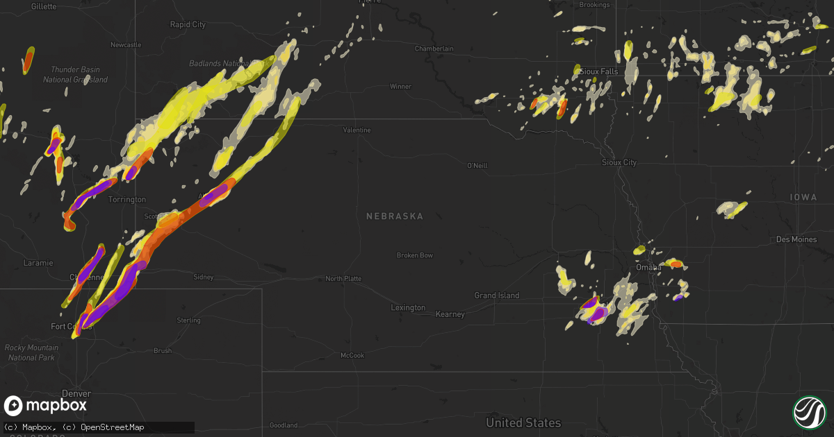
Hail Map in Nebraska on June 12, 2017
Get this storm
June 12 map
$229
one time, instant access
Download today. No call, no setup
Keep the $229
Bought the map and want the full workflow? Apply the entire $229 to a subscription within 7 days. None of it is wasted.
Every map, not just this one
This buys you this map. Subscription and you get every map we run, in the markets you choose from a few cities to whole states to nationwide. Plus real-time alerts the moment a storm fires.
Contact data
Name, contact info, occupancy, even credit band for addresses in the footprint. You go from where it hit to who to call.
Become the source they trust
Unlimited branding weather history reports on demand. You already have the documented answer ready for the property owner, and you are the one who showed up with it.
Property data and RoofTrace estimates
Pull up any address you have got, its value and the exact code rules for that jurisdiction, straight from One Click Code. Then RoofTrace estimates the squares, pitch, and roof value, priced the way you price.
Storm reports in Nebraska
Nebraska
| Date | Description |
|---|---|
| 06/12/20176:56 PM CDT | Intermittent touchdowns. |
| 06/12/20176:35 PM CDT | *** 1 inj *** significant damage to two homesteads. One injured. Time based on radar. |
| 06/12/20176:24 PM CDT | Tornado on the ground. |
| 06/12/20178:47 AM CDT | Hail up to quarter size. |
| 06/12/20177:21 AM CDT | Reported via mping |
| 06/12/20177:20 AM CDT | Report via facebook |
| 06/12/20177:15 AM CDT | Crop damage due to estimated ping pong ball sized hail |
| 06/11/20179:40 PM CDT | A tornado reported 4 miles north of antioch. Power lines were also reported to be downed near the location. |
| 06/11/20179:30 PM CDT | A large cottonwood tree was snapped... Twisted...broken and spread around the ranch yard. A stack of lumber was lifted up and tossed around the yard. The time of the re |
| 06/11/20179:25 PM CDT | Very large hail... Perhaps baseball size... Was heard hitting the house. The time is estimated from radar. |
| 06/11/20179:22 PM CDT | 65 train cars blown over. |
| 06/11/20179:18 PM CDT | Report received via facebook. |
| 06/11/20179:15 PM CDT | Possible tornado. A business lost half its roof. Windows and doors were blown in. |
| 06/11/20179:15 PM CDT | A local report indicates 2.75 inch wind near ALLIANCE |
| 06/11/20179:10 PM CDT | Kansas st in alliance. |
| 06/11/20179:00 PM CDT | Near the morrill-box butte county line. |
| 06/11/20178:56 PM CDT | A local report indicates 1.00 inch wind near 6 SSW RUSHVILLE |
| 06/11/20178:15 PM CDT | Large trees down. Roof lifted off a building on the school property. |
| 06/11/20178:15 PM CDT | Trees and power lines down. Houses severely damaged. A storage shed and tractor were swept away. Power lines snapped. Time based on radar. |
| 06/11/20178:15 PM CDT | A local report indicates 1.50 inch wind near 13 S HAY SPRINGS |
| 06/11/20178:15 PM CDT | Trees and power lines down in bayard. Time based on radar. |
| 06/11/20178:15 PM CDT | Trees and power lines down. Time based on radar. |
| 06/11/20178:05 PM CDT | Rain-wrapped tornado. |
| 06/11/20178:03 PM CDT | Quarter to half dollar hail |
| 06/11/20178:03 PM CDT | A local report indicates 1.00 inch wind near 10 S GERING |
| 06/11/20177:38 PM CDT | 41.59n/-103.58 |
| 06/11/20177:29 PM CDT | Tornado on the ground. |
| 06/11/20177:18 PM CDT | Tornado on the ground. |
| 06/11/20177:12 PM CDT | Tornado on the ground. |
| 06/11/20177:10 PM CDT | Tornado on the ground. |
| 06/11/20177:06 PM CDT | Tornado on the ground. |
| 06/11/20177:05 PM CDT | Tornado on the ground. |
All States Impacted by Hail Map on June 12, 2017
Cities Impacted by Hail Map on June 12, 2017
- Nunn, CO
- Pierce, CO
- Ault, CO
- Post, TX
- Unadilla, NE
- Syracuse, NE
- Burr, NE
- Plainview, TX
- Petersburg, TX
- Lockney, TX
- Lorenzo, TX
- Floydada, TX
- Fort Atkinson, WI
- Jefferson, WI
- Lake Mills, WI
- Wheatland, WY
- Bearcreek, MT
- Fromberg, MT
- Bridger, MT
- Glidden, IA
- Coon Rapids, IA
- Amboy, MN
- Delavan, MN
- Winnebago, MN
- Kaycee, WY
- Plattsmouth, NE
- Murray, NE
- Waldorf, MN
- Pemberton, MN
- Janesville, MN
- Minatare, NE
- Ten Sleep, WY
- Braddock, ND
- Westport, SD
- Dawson, ND
- Chancellor, SD
- Ceresco, NE
- Valparaiso, NE
- Herman, MN
- Harrisburg, SD
- Canton, SD
- Beresford, SD
- Lennox, SD
- Centerville, SD
- Worthing, SD
- Redgranite, WI
- Princeton, WI
- Berlin, WI
- Neshkoro, WI
- Cheyenne, WY
- Chadron, NE
- Whitney, NE
- Meeteetse, WY
- Thermopolis, WY
- Kress, TX
- Tulia, TX
- Lakefield, MN
- Jackson, MN
- Scotland, SD
- Torrington, WY
- Gail, TX
- Cottage Grove, WI
- Wellston, MI
- Oconomowoc, WI
- Tuthill, SD
- Missouri Valley, IA
- Blackfoot, ID
- Firth, ID
- Alliance, NE
- Ellsworth, NE
- Good Thunder, MN
- Chokio, MN
- Dumont, MN
- Morris, MN
- Bayard, NE
- Midland, SD
- Minden, IA
- Treynor, IA
- Oakland, IA
- McClelland, IA
- Carson, IA
- Grayling, MI
- Hereford, CO
- Carpenter, WY
- Burns, WY
- Grover, CO
- Odessa, TX
- Abie, NE
- Linwood, NE
- Prague, NE
- Bruno, NE
- Adams, MN
- Little Cedar, IA
- Riceville, IA
- Rose Creek, MN
- Lyle, MN
- Osage, IA
- Stacyville, IA
- McIntire, IA
- Saint Ansgar, IA
- Oelrichs, SD
- Edgemont, SD
- Glenrock, WY
- Windsor, CO
- Eaton, CO
- Carr, CO
- Loveland, CO
- Fort Collins, CO
- Timnath, CO
- Ackerly, TX
- Crawford, NE
- Wanblee, SD
- Rushville, NE
- Allen, SD
- Martin, SD
- Batesland, SD
- Gordon, NE
- Porcupine, SD
- Kadoka, SD
- Interior, SD
- Casper, WY
- Inwood, IA
- Doon, IA
- Lewisville, MN
- Truman, MN
- Woodworth, ND
- Hancock, WI
- Bancroft, WI
- Waupun, WI
- Douglas, WY
- Tomah, WI
- Wilton, WI
- Kendall, WI
- Camp Douglas, WI
- North Freedom, WI
- Donnelly, MN
- Spirit Lake, IA
- Arlington, WI
- Merrimac, WI
- Waunakee, WI
- Dane, WI
- Deforest, WI
- Lodi, WI
- Staplehurst, NE
- Shelby, NE
- Surprise, NE
- Ulysses, NE
- Rising City, NE
- Gresham, NE
- Hemingford, NE
- Hay Springs, NE
- Waubay, SD
- Clark, SD
- South Shore, SD
- Summit, SD
- Watertown, SD
- Ortley, SD
- Wallace, SD
- Henry, SD
- Florence, SD
- Bradley, SD
- Garden City, SD
- Guernsey, WY
- Bryant, SD
- Willow Lake, SD
- Vienna, SD
- Fe Warren Afb, WY
- Plymouth, WI
- Elkhart Lake, WI
- Shelley, ID
- Taopi, MN
- Chester, IA
- Estherville, IA
- Irene, SD
- Mission Hill, SD
- Emerson, IA
- Silverton, TX
- Pine Ridge, SD
- Albin, WY
- Lagrange, WY
- Grand Meadow, MN
- Morse Bluff, NE
- Long Valley, SD
- Red Oak, IA
- Hastings, IA
- Henderson, IA
- Pine Bluffs, WY
- Bushnell, NE
- Big Timber, MT
- Roberts, ID
- Harrison, MT
- Hillsdale, WY
- Gardendale, TX
- Warrens, WI
- Okabena, MN
- Chester, SD
- Kyle, SD
- Harrison, NE
- Merriman, NE
- Bingham, NE
- Bridgeport, NE
- Angora, NE
- Sheldon, IA
- Ashton, IA
- Crescent, IA
- Honey Creek, IA
- Underwood, IA
- Neola, IA
- Roca, NE
- Martell, NE
- Lincoln, NE
- Buffalo, WY
- Campbellsport, WI
- Elma, IA
- Alta Vista, IA
- Orchard, IA
- Charles City, IA
- Floyd, IA
- Rudd, IA
- Markesan, WI
- Madison, SD
- Wentworth, SD
- Cleveland, MS
- Fort Pierre, SD
- Manistee, MI
- Garrett, WY
- Glendo, WY
- Fluvanna, TX
- Titonka, IA
- Harrisburg, NE
- Buffalo Center, IA
- Burt, IA
- Lone Rock, IA
- Swea City, IA
- Bancroft, IA
- Algona, IA
- Fenton, IA
- Lanesboro, MN
- Chatfield, MN
- Crane, TX
- Oakfield, WI
- Brandon, WI
- Rosendale, WI
- Manderson, WY
- Owatonna, MN
- Elmore, MN
- Lawler, IA
- Waltham, MN
- Sargeant, MN
- Menno, SD
- Olivet, SD
- Cody, WY
- Neosho, WI
- Hartford, WI
- Rubicon, WI
- Hale Center, TX
- Lusk, WY
- Mount Calvary, WI
- Luverne, MN
- Hardwick, MN
- Two Dot, MT
- Wells, MN
- Saint James, MN
- Powell, WY
- Fulda, MN
- Heron Lake, MN
- Albert Lea, MN
- Alden, MN
- Hartland, MN
- Happy, TX
- Wellington, CO
- Metamora, IN
- Batesville, IN
- Kanaranzi, MN
- Ellsworth, MN
- Magnolia, MN
- Rock Rapids, IA
- Columbus, WI
- McIntosh, SD
- Omaha, NE
- Fort Calhoun, NE
- Blair, NE
- Bennington, NE
- Kennard, NE
- Lake Andes, SD
- Geddes, SD
- Dubois, ID
- Monteview, ID
- Terreton, ID
- Dorchester, NE
- Friend, NE
- Sterling, NE
- Cardwell, MT
- Lincoln, ME
- Winn, ME
- Dexter, MN
- Mapleton, MN
- Denton, NE
- Freeman, SD
- Parker, SD
- Hurley, SD
- Viborg, SD
- Marion, SD
- Lesterville, SD
- Tyndall, SD
- Baldwin, MI
- Ramona, SD
- Oldham, SD
- Harrietta, MI
- Brethren, MI
- Wilmont, MN
- Adams, WI
- Friendship, WI
- Erwin, SD
- Westfield, WI
- Marshfield, WI
- Waseca, MN
- Imogene, IA
- Essex, IA
- Almond, WI
- Colwell, IA
- Nora Springs, IA
- New Hampton, IA
- Bismarck, ND
- Menoken, ND
- Wisconsin Dells, WI
- Portage, WI
- Wakonda, SD
- Luther, MI
- Jasper, MN
- Randolph, IA
- Malvern, IA
- Gallatin Gateway, MT
- Selfridge, ND
- Buckley, MI
- White Sulphur Springs, MT
- Graettinger, IA
- Ruthven, IA
- Wagner, SD
- Highmore, SD
- Holabird, SD
- Waverly, IA
- Ionia, IA
- Fredericksburg, IA
- Tripoli, IA
- White River, SD
- Okaton, SD
- Ocheyedan, IA
- Brewster, MN
- Round Lake, MN
- Bigelow, MN
- Worthington, MN
- Sibley, IA
- Strasburg, ND
- Little Rock, IA
- George, IA
- Springfield, ME
- Oelwein, IA
- Maynard, IA
- Peever, SD
- Alvord, IA
- Eldorado, WI
- Malone, WI
- Fond Du Lac, WI
- Van Dyne, WI
- Idaho Falls, ID
- Wykoff, MN
- Ellendale, MN
- Watertown, WI
- Yoder, WY
- Fort Laramie, WY
- Jay Em, WY
- Eagle Butte, SD
- Stewartville, MN
- Racine, MN
- Melville, MT
- Volin, SD
- Wesley, IA
- Idalou, TX
- Ralls, TX
- Wautoma, WI
- Laurel, IN
- Greensburg, IN
- Rushville, IN
- Murdo, SD
- Manilla, IN
- Waldron, IN
- Milroy, IN
- Colman, SD
- Frankfort, SD
- Basalt, ID
- Evansville, WY
- Avon, SD
- Tripp, SD
- Woden, IA
- Sheboygan Falls, WI
- Utica, MN
- Lewiston, MN
- Stockett, MT
- Hayfield, MN
- Cambridge, WI
- Western, NE
- Milligan, NE
- Scenic, SD
- La Farge, WI
- Hillsboro, WI
- Viola, WI
- Lyndon Station, WI
- Fairmont, MN
- Ceylon, MN
- Welcome, MN
- Greybull, WY
- Burlington, WY
- Basin, WY
- Decorah, IA
- Hospers, IA
- Armour, SD
- Hillpoint, WI
- Plain, WI
- Ririe, ID
- Baraboo, WI
- Granada, MN
- Lenorah, TX
- Remsen, IA
- Forman, ND
- Walton, NE
- Presho, SD
- Hickman, NE
- Sprague, NE
- Pleasant Dale, NE
- Crete, NE
- Hallam, NE
- Midwest, WY
- Ripon, WI
- Lake Crystal, MN
- Wheaton, MN
- Boyden, IA
- Andover, SD
- Conde, SD
- Oral, SD
- Hot Springs, SD
- Van Tassell, WY
- Smithwick, SD
- Wyola, MT
- Easton, MN
- Ashton, SD
- Mellette, SD
- Tustin, MI
- Indianola, MS
- Seward, NE
- Dwight, NE
- Gering, NE
- Melbeta, NE
- Colton, SD
- Newton, WI
- New Holstein, WI
- Valders, WI
- Mayville, WI
- Cleveland, WI
- Chilton, WI
- Sheboygan, WI
- Fairwater, WI
- Oshkosh, WI
- Brownsville, WI
- Pickett, WI
- Saint Cloud, WI
- Kiel, WI
- Sparta, WI
- Black River Falls, WI
- Tulare, SD
- Helena, MT
- Great Falls, MT
- Eagle Lake, MN
- Mankato, MN
- Elkhorn, NE
- Alvo, NE
- Murdock, NE
- Gretna, NE
- Nehawka, NE
- Milford, NE
- Nebraska City, NE
- Ashland, NE
- Dunbar, NE
- Waverly, NE
- Douglas, NE
- Greenwood, NE
- Bennet, NE
- Malcolm, NE
- South Bend, NE
- Eagle, NE
- Cook, NE
- Avoca, NE
- Springfield, NE
- Talmage, NE
- Palmyra, NE
- Weeping Water, NE
- Elmwood, NE
- Union, NE
- Louisville, NE
- Raymond, NE
- Otoe, NE
- Arcadia, WI
- Shell, WY
- Norcross, MN
- Conrad, IA
- Spring Valley, MN
- Brownsdale, MN
- Pierre, SD
- Midland, TX
- Hamer, ID
- Cambria, WI
- Randolph, WI
- Sun Prairie, WI
- Marshall, WI
- Ettrick, WI
- Mcgrew, NE
- Scottsbluff, NE
- Dodge Center, MN
- Redfield, SD
- Sauk City, WI
- Washta, IA
- Montello, WI
- Emmetsburg, IA
- Groton, SD
- Jefferson, IA
- Scranton, IA
- Banner, WY
- Clearmont, WY
- Hitchcock, SD
- Leola, SD
- Norwalk, WI
- Reed Point, MT
- Columbus, MT
- Allison, IA
- Beaver Creek, MN
- Garretson, SD
- Geneva, IA
- Orient, SD
- Cross Plains, WI
- Madison, WI
- Prairie Du Sac, WI
- Black Earth, WI
- Poynette, WI
- Windsor, WI
- Mazomanie, WI
- Morrisonville, WI
- Johnson Creek, WI
- Blue Earth, MN
- Ledyard, IA
- Iron Ridge, WI
- Bagley, IA
- Doddsville, MS
- Wild Rose, WI
- Wisconsin Rapids, WI
- Oldenburg, IN
- Larchwood, IA
- Draper, SD
- Harlowton, MT
- Belleville, WI
- Verona, WI
- Rockham, SD
- Twin Brooks, SD
- Stevens Point, WI
- Aberdeen, SD
- Ringsted, IA
- Dolliver, IA
- Wallingford, IA
- Juneau, WI
- Horicon, WI
- Manderson, SD
- Waukesha, WI
- Delafield, WI
- Coloma, WI
- Edgerton, WY
- Mount Horeb, WI
- New Glarus, WI
- Blanchardville, WI
- De Smet, SD
- Powder Springs, GA
- Acworth, GA
- Kennesaw, GA
- Necedah, WI
- New Lisbon, WI
- Philip, SD
- Mandan, ND
- Hartville, WY
- Doland, SD
- Cascade, WI
- Clinton, MN
- Graceville, MN
- Byron, MN
- Hayes, SD
- Mattawamkeag, ME
- Medway, ME
- East Millinocket, ME
- Waucoma, IA
- Cadillac, MI
- Raymond, SD
- Avoca, MN
- Barry, MN
- Bridgewater, SD
- Idlewild, MI
- Weston, NE
- Strawberry Point, IA
- Onida, SD
- Agar, SD
- Alden, IA
- Amherst, WI
- Plover, WI
- Boca Grande, FL
- Wilmot, SD
- Ipswich, SD
- Lima, MT
- McBain, MI
- Ontario, WI
- Peterson, MN
- Fountain, MN
- Mansfield, SD
- Hull, IA
- Plainfield, IA
- Gays Mills, WI
- Arena, WI
- Green Lake, WI
- Terril, IA
- Armstrong, IA
- Dickens, IA
- Sherburn, MN
- Cylinder, IA
- Dunnell, MN
- Emery, SD
- Shawnee, WY
- Westbrook, MN
- Windom, MN
- Alpha, MN
- Cresco, IA
- Marquette, WI
- Elbow Lake, MN
- Alton, IA
- Hayti, SD
- Meadow, SD
- Clarks Grove, MN
- Blair, WI
- Carpenter, SD
- Dover, MN
- Saint Charles, MN
- Dumont, IA
- Ackley, IA
- Spencer, ID
- Paton, IA
- Lemmon, SD
- Parkston, SD
- Utica, NE
- David City, NE
- Friesland, WI
- Vivian, SD
- Davey, NE
- Lake Wilson, MN
- Jackson, OH
- Colgate, WI
- Hubertus, WI
- Germantown, WI
- Richfield, WI
- Lake Preston, SD
- Lake Norden, SD
- Alexandria, MN
- Garfield, MN
- Blooming Prairie, MN
- Grand Marsh, WI
- Yale, SD
- Mount Eden, KY
- Osakis, MN
- Alpena, SD
- Meriden, WY
- Millinocket, ME
- Bitely, MI
- Delmont, SD
- Bricelyn, MN
- Winfred, SD
- Three Forks, MT
- Barnard, SD
- Browns Valley, MN
- Dedham, IA
- Carroll, IA
- Rushford, MN
- Winona, MN
- Houston, MN
- Iona, ID
- Rollingstone, MN
- Austin, MN
- Turton, SD
- Cambridge City, IN
- Livingston, MT
- Rexburg, ID
- Woodstock, MN
- Cascade, MT
- Beardsley, MN
- Sisseton, SD
- Ellendale, ND
- Frederick, SD
- Boscobel, WI
- Blue River, WI
- Mosinee, WI
- Hawkeye, IA
- Menan, ID
- Coon Valley, WI
- Cashton, WI
- Bangor, WI
- Rockland, WI
- Cazenovia, WI
- Lime Ridge, WI
- La Valle, WI
- Clinton, LA
- Egan, SD
- Bozeman, MT
- Spring Green, WI
- Plainview, MN
- Elgin, MN
- Sardis, MS
- Roberts, MT
- Joliet, MT
- Shelby, MI
- Hartford, SD
- Humboldt, SD
- Tabor, IA
- Richland Center, WI
- Fremont, WI
- Poy Sippi, WI
- Winneconne, WI
- Pine River, WI
- Omro, WI
- New Richland, MN
- Minnesota Lake, MN
- Muscoda, WI
- Columbia, SD
- Frost, MN
- Mishicot, WI
- Glenville, MN
- Council Bluffs, IA
- Clarksville, IA
- Manitowoc, WI
- Mindoro, WI
- Melrose, WI
- Morristown, MN
- Medford, MN
- Faribault, MN
- Hartland, WI
- Whittemore, IA
- Granville, IA
- Forbes, ND
- Clancy, MT
- Reed City, MI
- Chase, MI
- Downing, WI
- Clear Lake, WI
- Prairie Farm, WI
- Tecumseh, NE
- Worland, WY
- Slaton, TX
- Lodge Grass, MT
- Hazel, SD
- Lakota, IA
- Blunt, SD
- Dupree, SD
- Parmelee, SD
- Norris, SD
- Cogswell, ND
- Britton, SD
- West Bend, IA
- Sterling, ND
- Free Soil, MI
- Bee, NE
- Faulkton, SD
- Rosston, AR
- Glenwood, IA
- Adrian, MN
- Kenneth, MN
- Lismore, MN
- Manilla, IA
- Crosbyton, TX
- Dodgeville, WI
- Tea, SD
- Scandinavia, WI
- Pine Island, MN
- Washington Court House, OH
- Holmen, WI
- Sumner, IA
- Belfry, MT
- Arlington, IA
- Wadena, IA
- Fayette, IA
- Falmouth, MI
- Carthage, AR
- Sparkman, AR
- Lance Creek, WY
- Randalia, IA
- Westgate, IA
- Ormsby, MN
- Trimont, MN
- Spencer, SD
- Ethan, SD
- Ireton, IA
- Sioux Center, IA
- Flandreau, SD
- Pettibone, ND
- Manhattan, MT
- Pittsville, WI
- Iowa Falls, IA
- Altura, MN
- Mantorville, MN
- Seneca, SD
- Rushmore, MN
- Reading, MN
- Westby, WI
- Chaseburg, WI
- Lyman, NE
- Ridgeway, IA
- Bristol, SD
- Hecla, SD
- Waterloo, WI
- Vernon Center, MN
- Holland, MN
- Pipestone, MN
- Hudson, SD
- Como, MS
- Orange City, IA
- Tintah, MN
- Glenbeulah, WI
- Shawmut, MT
- Bellvue, CO
- Springfield, SD
- Silver City, IA
- Edgerton, WI
- Webster, SD
- Frederika, IA
- Darlington, WI
- Mineral Point, WI
- Bayard, IA
- Templeton, IA
- Java, SD
- Norris, MT
- Marsland, NE
- Blairsburg, IA
- Gillette, WY
- Reedsburg, WI
- Genoa, WI
- Viroqua, WI
- Curlew, IA
- Edgerton, MN
- Steen, MN
- Hills, MN
- Hawk Springs, WY
- Rigby, ID
- Centerville, IN
- Milton, IN
- La Crosse, WI
- Chandler, MN
- Galesville, WI
- Greenville, IA
- Spencer, IA
- Preston, MN
- La Crescent, MN
- Hanska, MN
- Madelia, MN
- Kewaskum, WI
- West Bend, WI
- Onaka, SD
- Deerfield, WI
- Loganville, WI
- Rockford, IA
- Harrold, SD
- Hazelton, ND
- Morristown, SD
- Yankton, SD
- Sioux Falls, SD
- Coyanosa, TX
- Fort Stockton, TX
- Monahans, TX
- Grandfalls, TX
- Imperial, TX
- Abernathy, TX
- Marathon, TX
- Milford, IA
- Chugwater, WY
- Livermore, CO
- Laporte, CO
- Severance, CO
- Claremont, MN
- Kasson, MN


