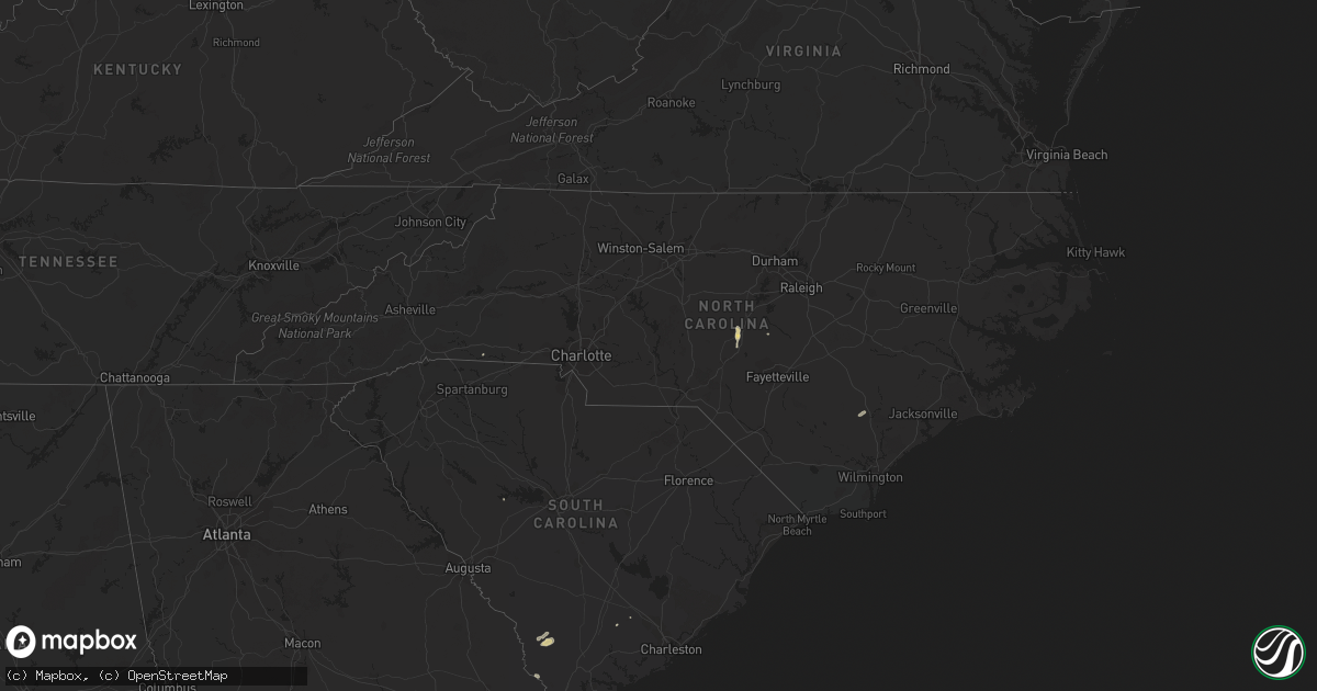
Hail Map in North Carolina on June 12, 2014
Get this storm
June 12 map
$229
one time, instant access
Download today. No call, no setup
Keep the $229
Bought the map and want the full workflow? Apply the entire $229 to a subscription within 7 days. None of it is wasted.
Every map, not just this one
This buys you this map. Subscription and you get every map we run, in the markets you choose from a few cities to whole states to nationwide. Plus real-time alerts the moment a storm fires.
Contact data
Name, contact info, occupancy, even credit band for addresses in the footprint. You go from where it hit to who to call.
Become the source they trust
Unlimited branding weather history reports on demand. You already have the documented answer ready for the property owner, and you are the one who showed up with it.
Property data and RoofTrace estimates
Pull up any address you have got, its value and the exact code rules for that jurisdiction, straight from One Click Code. Then RoofTrace estimates the squares, pitch, and roof value, priced the way you price.
Storm reports in North Carolina
North Carolina
| Date | Description |
|---|---|
| 06/12/20144:42 PM CDT | Few trees down in hays. Large tree blocking oak ridge rd near rock creek |
| 06/12/20144:15 PM CDT | Trees down on a power pole near the intersection of steel bridge and creekwood. |
| 06/12/20144:08 PM CDT | 1 tree down on powerlines near the intersection of chris cole rd and hendley rd. |
| 06/11/20147:45 PM CDT | One tree down near intersection of rag town road and old henrietta road. |
All States Impacted by Hail Map on June 12, 2014
Cities Impacted by Hail Map on June 12, 2014
- Winters, TX
- Roxie, MS
- Menard, TX
- Junction, TX
- London, TX
- Buchanan Dam, TX
- Burnet, TX
- Del Rio, TX
- Jonesville, LA
- Harrisonburg, LA
- Monterey, LA
- Vidalia, LA
- Natchez, MS
- Briggs, TX
- Lampasas, TX
- Purmela, TX
- Evant, TX
- Gatesville, TX
- Copperas Cove, TX
- Kempner, TX
- Ennis, TX
- Ferris, TX
- Palmer, TX
- Uvalde, TX
- Abilene, TX
- Marvell, AR
- Holly Grove, AR
- Cimarron, NM
- Rocksprings, TX
- Cameron, NC
- Carthage, NC
- Sanford, NC
- Thaxton, MS
- Oxford, MS
- Fredonia, TX
- Brady, TX
- Mason, TX
- Cherokee, TX
- Voca, TX
- San Saba, TX
- Pontotoc, MS
- Lometa, TX
- Sonora, TX
- Colorado Springs, CO
- Salem, AR
- Viola, AR
- Sturkie, AR
- Widener, AR
- Heth, AR
- La Pryor, TX
- Pollock, LA
- Barksdale, TX
- Leakey, TX
- Tallulah, LA
- Marianna, AR
- Robinsonville, MS
- Hughes, AR
- McCrory, AR
- Augusta, AR
- Anson, TX
- Okolona, MS
- Conroe, TX
- Porter, TX
- Ocala, FL
- Wagon Mound, NM
- Solano, NM
- Miami, NM
- Trementina, NM
- Conchas Dam, NM
- San Antonio, TX
- Manor, TX
- Austin, TX
- Kingsland, TX
- Marble Falls, TX
- Rochelle, TX
- Santa Anna, TX
- Lohn, TX
- Rockwood, TX
- Luray, SC
- Fairfax, SC
- Brunson, SC
- Mccomb, MS
- Magnolia, MS
- Newellton, LA
- Hardeeville, SC
- Franklin, TX
- Proctor, AR
- Kissimmee, FL
- Hico, TX
- Valley Mills, TX
- China Spring, TX
- Sedalia, CO
- Batesville, TX
- Stamford, TX
- Rule, TX
- Montverde, FL
- Clermont, FL
- Pearsall, TX
- Willow City, TX
- Llano, TX
- Fredericksburg, TX
- Athens, TX
- Clyde, TX
- Basile, LA
- Iota, LA
- Ash Flat, AR
- Glencoe, AR
- Camp, AR
- Broadway, NC
- Ballinger, TX
- Courtland, MS
- Batesville, MS
- Centerville, TX
- Hawley, TX
- Spicewood, TX
- Valley Spring, TX
- Etta, MS
- Amory, MS
- Randolph, MS
- Houlka, MS
- Aberdeen, MS
- Abbeville, MS
- Houston, MS
- Madison, FL
- Quitman, GA
- Pinetta, FL
- Las Vegas, NM
- Wynne, AR
- Sulphur, LA
- Meridian, TX
- Morgan, TX
- McCool, MS
- Oglesby, TX
- Concan, TX
- Utopia, TX
- Rio Frio, TX
- Wills Point, TX
- Terrell, TX
- Quinlan, TX
- Dyess Afb, TX
- Tuscola, TX
- Merkel, TX
- Tye, TX
- Seguin, TX
- Hunt, TX
- Woodville, MS
- Effie, LA
- Marksville, LA
- Tallahassee, FL
- Monticello, FL
- Du Pont, GA
- Goldsboro, TX
- Ovalo, TX
- Lawn, TX
- Fort Shaw, MT
- Cascade, MT
- Simms, MT
- Sun River, MT
- Iredell, TX
- Mountain Home, TX
- Vanderpool, TX
- Parkin, AR
- Pattison, MS
- Hazlehurst, MS
- Knippa, TX
- Fargo, GA
- Hampton, AR
- Tutwiler, MS
- Big Sandy, MT
- Orlando, FL
- Canyon Creek, MT
- Canton, TX
- Coden, AL
- Bayou La Batre, AL
- Clarendon, AR
- Kathleen, FL
- Talpa, TX
- Fort Benton, MT
- Loma, MT
- Saint Augustine, FL
- Fordyce, AR
- Brookhaven, MS
- Broaddus, TX
- Etoile, TX
- Pocahontas, AR
- Dundee, MS
- Clifton, TX
- Raynesford, MT
- Geyser, MT
- Ray City, GA
- Cedar Park, TX
- Leander, TX
- Malakoff, TX
- Trinidad, TX
- Eight Mile, AL
- Crawford, TX
- Springer, NM
- Ackerman, MS
- Weir, MS
- Evening Shade, AR
- Leesville, TX
- Nixon, TX
- Wolf Creek, MT
- Stewart, MS
- Doole, TX
- Voss, TX
- Millersview, TX
- Paint Rock, TX
- Poplar Grove, AR
- Cottageville, SC
- Wallace, NC
- Teachey, NC
- Willard, NC
- Ladonia, TX
- Stockett, MT
- Belt, MT
- Monarch, MT
- Palestine, TX
- Elkhart, TX
- Gonzales, TX
- Wrightsboro, TX
- Round Rock, TX
- Sardis, MS
- Commerce, TX
- New Edinburg, AR
- Goldthwaite, TX
- Medina, TX
- Jennings, LA
- Lake Park, GA
- Jennings, FL
- Bertram, TX
- Coleman, TX
- Batesville, AR
- Locust Grove, AR
- Cost, TX
- Smiley, TX
- Meadville, MS
- Camp Wood, TX
- Kingsland, AR
- New Caney, TX
- Spring, TX
- Elliston, MT
- Avon, MT
- Newport, AR
- Waycross, GA
- Earle, AR
- Bogue Chitto, MS
- Ruth, MS
- Springdale, WA
- Colt, AR
- Charleston, MS
- Vance, MS
- Batesburg, SC
- Cleveland, TX
- Jayess, MS
- Mammoth Spring, AR
- Gloster, MS
- Crosby, MS
- Fernandina Beach, FL
- Imboden, AR
- Hampton, SC
- Estill, SC
- Boyce, LA
- Bluffton, TX
- Tow, TX
- Comfort, TX
- Kerrville, TX
- Windermere, FL
- Sicily Island, LA
- Wisner, LA
- Henderson, AR
- Bexar, AR
- Mountain Home, AR
- Gepp, AR
- Moody, MO
- Elizabeth, AR
- Caulfield, MO
- West Plains, MO
- Roanoke, LA
- Crystal City, TX
- Prairie Hill, TX
- Wilmar, AR
- Summit, MS
- Liberty, MS
- Hamilton, TX
- Jonesboro, TX
- Forest City, NC
- Mooresboro, NC
- Haskell, TX
- Inglis, FL
- Manitou Springs, CO
- Pasadena, TX
- Melvin, TX
- Brownsboro, TX
- Chandler, TX
- Vaughn, MT
- Helena, AR
- Wolfe City, TX
- Hickory Ridge, AR
- Bradford, AR
- Sarah, MS
- Crenshaw, MS
- Sledge, MS
- Tunica, MS
- Garrison, MT
- Waterford, MS
- Cuero, TX
- Marquez, TX
- Evans, LA
- Merryville, LA
- Deridder, LA
- Rison, AR
- White Sulphur Springs, MT
- Great Falls, MT
- Whitney, TX
- Senatobia, MS
- Sabinal, TX
- Apopka, FL
- Port Gibson, MS
- Saint Joseph, LA
- Lorman, MS
- Kingsbury, TX
- San Marcos, TX
- New Braunfels, TX
- Eden, TX
- Beaumont, TX
- Devers, TX
- Brookeland, TX
- Hornbeck, LA
- Anacoco, LA
- Perry, FL
- Pineville, LA
- Dry Prong, LA
- Trout, LA
- Jena, LA
- Big Wells, TX
- Lake Charles, LA
- Cameron, LA
- Starks, LA
- Pleasanton, TX
- Floresville, TX
- Lincoln, MT
- Lyon, MS
- Coahoma, MS
- Orange, TX
- Usaf Academy, CO
- Bronson, TX
- San Augustine, TX
- Greenville, FL
- Pottsville, TX
- Elaine, AR
- Pineland, TX
- Cherry Valley, AR
- Rice, TX
- Falls City, TX
- Banner, MS
- Paris, MS
- Monticello, AR
- Louann, AR
- Wesson, MS
- Lake Wales, FL
- Power, MT
- Helena, MT
- Marysville, MT
- Trinidad, CO
- Utica, MS
- McCall Creek, MS
- Bruceville, TX
- Larue, TX
- Yoakum, TX
- Ridgeville, SC
- Paragould, AR
- Shepherd, TX
- Gouldbusk, TX
- Hext, TX
- Richland Springs, TX
- Killeen, TX
- Union Church, MS
- Punta Gorda, FL
- Crawfordsville, IN
- Ulm, AR
- Carlisle, AR
- Coldwater, MS
- Pearl, MS
- Florence, MS
- Richland, MS
- Valera, TX
- Pontotoc, TX
- Flint, TX
- Carlton, TX
- Clarksdale, MS
- De Valls Bluff, AR
- Normangee, TX
- Lorena, TX
- Hewitt, TX
- Woodway, TX
- Jackson, MS
- Byram, MS
- Novice, TX
- Rusk, TX
- Livingston, AL
- Boligee, AL
- Murchison, TX
- Belleview, FL
- Summerfield, FL
- Monticello, MS
- Cotton Plant, AR
- Savannah, GA
- Port Wentworth, GA
- Divide, CO
- Moore, TX
- Eustace, TX
- Humphrey, AR
- Maxwell, TX
- Garnett, SC
- Splendora, TX
- Fort Harrison, MT
- Cranfills Gap, TX
- Fayette, MS
- Warren, AR
- Kemp, TX
- Baird, TX
- Desha, AR


