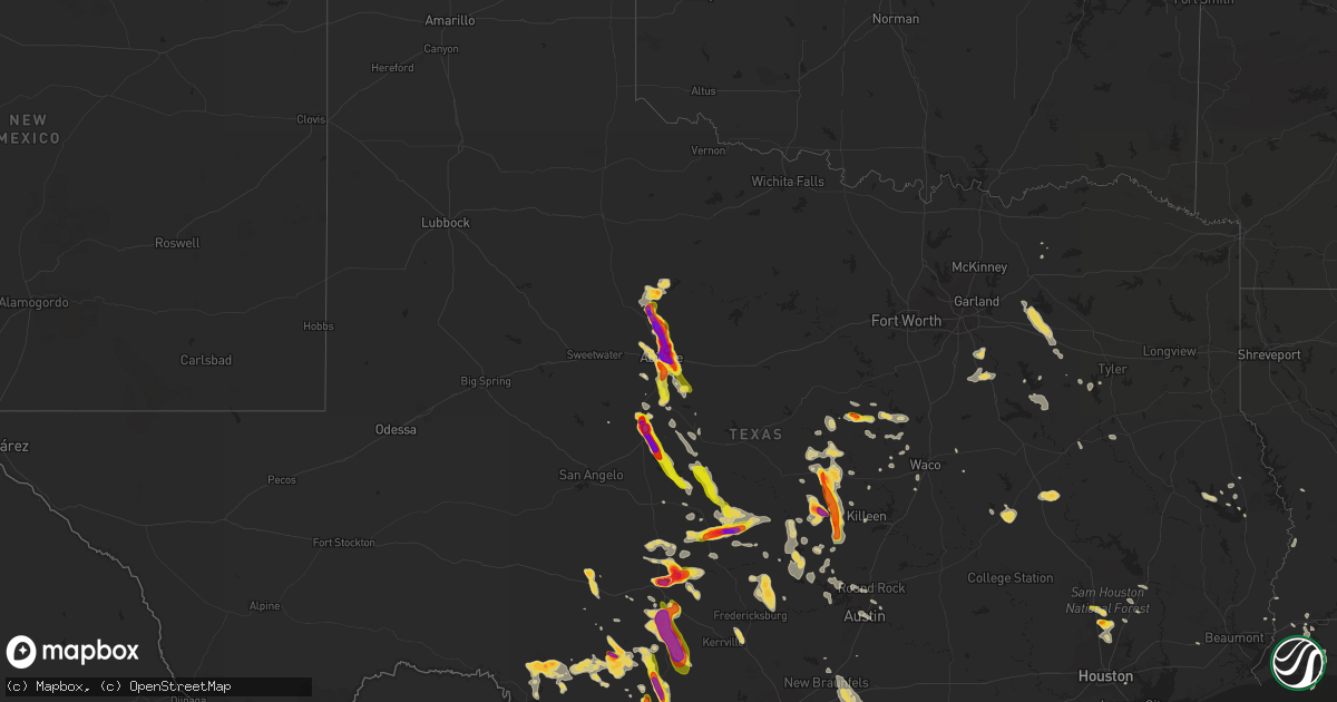
Hail Map on June 12, 2014
Get this storm
June 12 map
$229
one time, instant access
Download today. No call, no setup
Keep the $229
Bought the map and want the full workflow? Apply the entire $229 to a subscription within 7 days. None of it is wasted.
Every map, not just this one
This buys you this map. Subscription and you get every map we run, in the markets you choose from a few cities to whole states to nationwide. Plus real-time alerts the moment a storm fires.
Contact data
Name, contact info, occupancy, even credit band for addresses in the footprint. You go from where it hit to who to call.
Become the source they trust
Unlimited branding weather history reports on demand. You already have the documented answer ready for the property owner, and you are the one who showed up with it.
Property data and RoofTrace estimates
Pull up any address you have got, its value and the exact code rules for that jurisdiction, straight from One Click Code. Then RoofTrace estimates the squares, pitch, and roof value, priced the way you price.
States Impacted by Hail Map on June 12, 2014
Storm reports
South Carolina
| Date | Description |
|---|---|
| 06/12/20145:07 PM CDT | South carolina patrol reports tree down along magnolia street and elm street. |
| 06/12/20145:07 PM CDT | South carolina patrol reports several trees down in the varnville area. |
| 06/12/20144:13 PM CDT | South carolina highway patrol reported a tree down near the intersection of highway 46 and highway 170. |
Mississippi
| Date | Description |
|---|---|
| 06/12/20144:55 AM CDT | A tree was blown down across everett drennan road |
| 06/12/20144:05 AM CDT | Trees downed in jayess |
| 06/12/20144:05 AM CDT | Trees downed across the county |
| 06/12/20144:00 AM CDT | Trees downed on power lines on ford calcote road |
| 06/12/20143:53 AM CDT | Trees downed on lines at swilley road and warren lane |
| 06/12/20143:43 AM CDT | Trees downed on four to five homes in brookhaven |
| 06/12/20143:41 AM CDT | Multiple trees downed in beauregard |
| 06/12/20143:41 AM CDT | Trees downed in wesson |
| 06/12/20143:40 AM CDT | Trees downed in the new sight community |
| 06/12/20143:38 AM CDT | Trees downed across i-55 southbound near exit 48...mt zion road |
| 06/12/20143:35 AM CDT | Tree down on home in brookhaven |
| 06/12/20143:33 AM CDT | Trees and power lines downed along sylvarena road |
| 06/12/20143:25 AM CDT | Tree downed across ms highway 28 near barlow rd |
| 06/12/20143:22 AM CDT | Power lines were downed around okhissa lake |
| 06/12/20143:20 AM CDT | Tree downed across ms highway 28 near ms highway 547 |
| 06/12/20143:20 AM CDT | Tree downed across ms highway 28 near pleasant valley road |
| 06/12/20142:50 AM CDT | Tree downed across ms highway 18 near lomax road |
| 06/11/201410:30 PM CDT | Multiple trees down and one home damaged after tree fell on it along county road 135 north of hwy 32. Nws storm damage team will survey the damage for possible tornado |
| 06/11/201410:16 PM CDT | A local report indicates 1.00 inch wind near RANDOLPH |
| 06/11/201410:04 PM CDT | A local report indicates 1.75 inch wind near THAXTON |
| 06/11/20149:30 PM CDT | Police officer reported large hail doing damage to patrol car. |
Georgia
| Date | Description |
|---|---|
| 06/12/20142:30 PM CDT | City of brunswick fire department reports a powerline downed by thunderstorm wind gusts along newcastle street. Time of damage based on radar data. |
| 06/12/20141:55 PM CDT | Camden county 911 dispatch reports a tree downed by strong thunderstorm wind gusts along georgia highway 252 near white oak. Time of damage based on radar data. |
Idaho
| Date | Description |
|---|---|
| 06/11/20149:42 PM CDT | Recorded at the pocatello regional airport |
| 06/11/20149:20 PM CDT | Recorded by aberdeen weather station operated by inl. Wind recorded at approximately 50 feet above ground. |
Utah
| Date | Description |
|---|---|
| 06/12/20146:20 PM CDT | Large healthy tree snapped. Picture supplied by media. |
| 06/12/20146:15 PM CDT | Large healthy tree downed. Picture supplied by media. |
| 06/12/20146:00 PM CDT | Large healthy tree snapped half way up. Picture supplied by media. |
| 06/12/20145:41 PM CDT | Tooele sensor au720 |
| 06/12/20144:50 PM CDT | 2 semi trucks blown over on interstate 80 at mm16 |
| 06/12/20144:50 PM CDT | I80 at milepost 29 sensor ut33 |
| 06/11/20149:10 PM CDT | I-15 at plymouth |
Colorado
| Date | Description |
|---|---|
| 06/12/20146:08 PM CDT | A local report indicates 1.25 inch wind near 2 NW PETERSON AFB |
| 06/12/20146:07 PM CDT | Via amateur radio. |
| 06/12/20146:05 PM CDT | A local report indicates 1.25 inch wind near 2 NW PETERSON AFB |
| 06/12/20145:53 PM CDT | A local report indicates 1.00 inch wind near 6 NNE COLORADO SPRINGS |
| 06/12/20145:52 PM CDT | A local report indicates 1.00 inch wind near 4 NNE COLORADO SPRINGS |
Texas
| Date | Description |
|---|---|
| 06/12/20146:57 PM CDT | Hail falling at the time of the report. Mostly quarter size hail with a few as big as eggs. |
| 06/12/20146:52 PM CDT | A local report indicates 70 MPH wind near LAWN |
| 06/12/20146:35 PM CDT | 1.00 to 1.50 inch hail in the woodloch area. Received from twitter. |
| 06/12/20146:35 PM CDT | A local report indicates 60 MPH wind near TUSCOLA |
| 06/12/20146:30 PM CDT | Brief touchdown... Roof blown off a home. |
| 06/12/20146:27 PM CDT | A local report indicates 1.50 inch wind near EVANT |
| 06/12/20146:25 PM CDT | A local report indicates 2.00 inch wind near EVANT |
| 06/12/20146:21 PM CDT | A local report indicates 1.00 inch wind near EVANT |
| 06/12/20146:20 PM CDT | A local report indicates 1.75 inch wind near POTOSI |
| 06/12/20146:20 PM CDT | Cocorahs report |
| 06/12/20146:11 PM CDT | A local report indicates 60 MPH wind near 3 ESE ABILENE |
| 06/12/20146:09 PM CDT | A local report indicates 60 MPH wind near 3 ESE ABILENE |
| 06/12/20146:06 PM CDT | A local report indicates 2.50 inch wind near 2 SE ABILENE |
| 06/12/20146:06 PM CDT | Shave report via nssl |
| 06/12/20146:05 PM CDT | A local report indicates 1.25 inch wind near TYE |
| 06/12/20145:57 PM CDT | Baseball size hail near abilene christian university campus |
| 06/12/20145:55 PM CDT | A local report indicates 4.50 inch wind near 2 SW HAMBY |
| 06/12/20145:50 PM CDT | Shave report of baseball hail |
| 06/12/20145:46 PM CDT | 58 mph wind measured at ktxs studio with hail up to the size of baseballs. |
| 06/12/20145:46 PM CDT | 58 mph wind measured at ktxs studio with hail up to the size of baseballs. |
| 06/12/20145:40 PM CDT | Shave report via nssl |
| 06/12/20145:36 PM CDT | Half dollar sized hail hear hawley |
| 06/12/20145:28 PM CDT | A local report indicates 2.75 inch wind near 5 ENE HAWLEY |
| 06/12/20145:18 PM CDT | A local report indicates 2.00 inch wind near 5 N HAWLEY |
| 06/12/20145:00 PM CDT | A local report indicates 1.25 inch wind near 6 E TELEGRAPH |
| 06/12/20144:55 PM CDT | A local report indicates 1.00 inch wind near 7 E TELEGRAPH |
| 06/12/20144:40 PM CDT | A local report indicates 1.00 inch wind near 3 NNE STAMFORD |
| 06/12/20144:35 PM CDT | A local report indicates 1.75 inch wind near STAMFORD |
| 06/11/201411:21 PM CDT | Trees blown into power lines causing loss of power. |
| 06/11/201411:14 PM CDT | Numerous trees blown down and power lines between kyle... Buda and dripping springs. |
| 06/11/201411:04 PM CDT | Power poles and large trees down |
| 06/11/201410:45 PM CDT | 8 inch diameter china berry tree blown down...5 inch diameter elm tree blown down...lots of tree damage in neighborhood...straight line winds from north to south were o |
| 06/11/201410:40 PM CDT | Along state highway 6 |
| 06/11/201410:39 PM CDT | Possible microburst moved potted plants...large shrubs...and 300 lb yard furniture all in different directions. |
| 06/11/201410:30 PM CDT | Multiple large trees snapped and uprooted. A woody fence was blown at least 30 yards away. |
| 06/11/201410:30 PM CDT | Delayed report...large trees uprooted and 4 inch diameter tree limbs snapped. Roof damage to a barn. |
| 06/11/201410:25 PM CDT | Several very large trees blown over. |
| 06/11/201410:23 PM CDT | Part of the hexel warehouse near seguin has major damage. |
| 06/11/201410:20 PM CDT | 5 inch branches tore off some lace bark elm trees |
| 06/11/201410:15 PM CDT | Damage to a 40 year old cedar elm...6 inch diameter oak tree branches tore off...straight line winds observed |
| 06/11/201410:15 PM CDT | A local report indicates 1.75 inch wind near 5 SE IREDELL |
| 06/11/201410:05 PM CDT | Delayed report...roofs torn off two houses...front porch dropped into another yard. Very large trees blown down into houses. House debris found several streets away. |
| 06/11/201410:00 PM CDT | Numerous trees blown down... Rows of fences blown over. |
| 06/11/201410:00 PM CDT | Wind gusts to 70 mph. Several roofs damage and many large trees down. |
| 06/11/20149:54 PM CDT | Very strong winds... Blew the roof of a home. |
| 06/11/20149:54 PM CDT | Very strong winds... Blew the roof of a home. |
| 06/11/20149:45 PM CDT | 20 percent of composition shingles on roof blown off home |
| 06/11/20149:38 PM CDT | Loss of power for most of uvalde... Planes overturned... Lots of half inch size hail and very high winds. |
| 06/11/20149:30 PM CDT | A few tree limbs down. The limbs were 8 feet in length. |
| 06/11/20149:25 PM CDT | Numerous tree limbs down on the east side of town. One tree blocking the road. The tree was 30 feet in length. |
| 06/11/20149:20 PM CDT | 66 mph wind gust. |
| 06/11/20149:20 PM CDT | A local report indicates 1.00 inch wind near 6 ESE MENARD |
| 06/11/20149:15 PM CDT | Four panels of a wood privacy fence blown away...a large arizona ash and a large red oak tree blown down...lots of 6 inch tree branches tore off... |
| 06/11/20149:11 PM CDT | Tree toppled and 6 inch limbs downed |
| 06/11/20149:10 PM CDT | Unconfirmed report of a tornado near joppa. |
| 06/11/20149:10 PM CDT | Numerous trees down and damge to a home. Off of highway 1174 near joppa. |
| 06/11/20149:00 PM CDT | Portion of metal roof peeled back...10 inch cedar elm blown over...up to 10 inch diameter tree branches tore off. Time of occurrence is approximate |
| 06/11/20148:50 PM CDT | Wind gusts estimated between 60 and 70 mph blew the tops of portions of their barns and horse stalls |
| 06/11/20148:45 PM CDT | Roof was reportedly blown off at the rochelle public school. |
| 06/11/20148:42 PM CDT | Trees down in the rochelle area. Winds estimated at 65 mph. |
| 06/11/20148:40 PM CDT | 4 to 6 inch diameter tree limbs down on highway 190 |
| 06/11/20148:40 PM CDT | 4 to 6 inch tree limbs down at county road 300 and fm 765 |
| 06/11/20148:35 PM CDT | 4 inch mesquite limbs down around lohn. |
| 06/11/20148:35 PM CDT | A local report indicates 78 MPH wind near 3 NNE BRADY |
| 06/11/20148:30 PM CDT | A local report indicates 1.00 inch wind near 2 E PEAR VALLEY |
| 06/11/20148:30 PM CDT | Top portion of a weak cedar elm blown over...several 6 inch diameter tree branches tore off trees...straight line winds were observed |
| 06/11/20148:18 PM CDT | Tornado reported on the ground by several storm chasers. |
| 06/11/20148:16 PM CDT | A local report indicates 2.00 inch wind near 6 N LAMPASAS |
| 06/11/20148:14 PM CDT | One oak tree and tree branches were blown down. A mobile irrigation system was damaged |
| 06/11/20148:07 PM CDT | A local report indicates 60 MPH wind near 10 NNE MILLERSVIEW |
| 06/11/20148:07 PM CDT | A local report indicates 1.00 inch wind near 10 NNE MILLERSVIEW |
| 06/11/20148:05 PM CDT | A local report indicates 1.75 inch wind near 4 W KEMPNER |
| 06/11/20148:00 PM CDT | 4 inch diameter tree limbs down |
| 06/11/20148:00 PM CDT | A local report indicates 2.25 inch wind near 2 SE VOCA |
| 06/11/20147:59 PM CDT | A local report indicates 2.50 inch wind near VOCA |
| 06/11/20147:59 PM CDT | Large hail reported. |
| 06/11/20147:57 PM CDT | 1.00 inch hail in the conroe area from twitter. |
| 06/11/20147:55 PM CDT | Wind driven hail busted northwest facing windows. |
| 06/11/20147:53 PM CDT | Large hail just ended at the time of the report. |
| 06/11/20147:53 PM CDT | Several good size trees down with several limbs of 6 inches in diameter down. |
| 06/11/20147:51 PM CDT | A local report indicates 62 MPH wind near SANTA ANNA |
| 06/11/20147:50 PM CDT | A local report indicates 1.75 inch wind near VOCA |
| 06/11/20147:50 PM CDT | A local report indicates 2.75 inch wind near 5 SSW LONDON |
| 06/11/20147:36 PM CDT | A few tree limbs down at the bar z ranch. The tree limbs were 20 feet in length. |
| 06/11/20147:30 PM CDT | Between hamilton and pottsville |
| 06/11/20147:23 PM CDT | A local report indicates 2.75 inch wind near 7 S LONDON |
| 06/11/20147:16 PM CDT | A local report indicates 4.50 inch wind near HATCHEL |
| 06/11/20147:15 PM CDT | A local report indicates 2.75 inch wind near 7 SW LONDON |
| 06/11/20147:12 PM CDT | A local report indicates 1.75 inch wind near 1 N HATCHEL |
| 06/11/20147:10 PM CDT | A local report indicates 4.50 inch wind near 11 SW LONDON |
| 06/11/20147:10 PM CDT | A local report indicates 2.00 inch wind near 4 SE WINTERS |
| 06/11/20147:05 PM CDT | Quarter size hail continues. |
| 06/11/20147:05 PM CDT | A local report indicates 70 MPH wind near 4 NNE CREWS |
| 06/11/20147:03 PM CDT | On fm1690 |
| 06/11/20147:00 PM CDT | One inch size hail along with some tree damage. |
Pennsylvania
| Date | Description |
|---|---|
| 06/12/20144:35 PM CDT | Trees and wires down. One utility pole snapped. |
Arkansas
| Date | Description |
|---|---|
| 06/12/20145:50 PM CDT | Trees were reported down at rye. |
| 06/12/20145:31 PM CDT | A local report indicates 1.00 inch wind near DESHA |
| 06/12/20144:33 PM CDT | Quarter sized hail near marked tree |
| 06/12/20144:33 PM CDT | A local report indicates 71 MPH wind near MARKED TREE |
| 06/12/20144:30 PM CDT | Two high profile vehicles overturned highway 63 |
| 06/12/20144:30 PM CDT | Numerous power poles down northside highway 1. Also trees down and 2 foot deep water in yards near houses. |
| 06/12/20144:26 PM CDT | Trees on cars and a roof peeled back on a house. |
| 06/12/20144:25 PM CDT | Trees were downed on or near highway 79 at the dallas and cleveland county line. |
| 06/12/20143:54 PM CDT | Tree down jones road south of paragould |
| 06/12/20143:54 PM CDT | Power lines down highway 29 |
| 06/12/20143:54 PM CDT | Trees down |
| 06/12/20143:45 PM CDT | Very large tree on car near hwy 49 in paragould 2 niles s of hwy 412. Two large trees down 2 miles sw of hwy 412. Large limbs down city wide. |
| 06/12/20143:45 PM CDT | Wind gusts estimated in excess of 60 mph. |
| 06/12/20143:20 PM CDT | Large tree limbs were reported down across southern jackson and north woodruff county. |
| 06/11/20149:43 PM CDT | A 61 mph gust was measured at the stuttgart airport. |
Montana
| Date | Description |
|---|---|
| 06/12/20143:30 AM CDT | Duration of hail 20 minutes. |
| 06/12/20142:50 AM CDT | Mostly pea-sized hail |
| 06/11/201411:58 PM CDT | Numerous penny-sized hail and one estimated golf ball size hail stone |
New Mexico
| Date | Description |
|---|---|
| 06/11/20147:35 PM CDT | Pea to quarter size hail for 10 minutes. |
Missouri
| Date | Description |
|---|---|
| 06/12/20145:30 PM CDT | Trained spotter measured sixty mph wind gusts and pea-sized hail |
Florida
| Date | Description |
|---|---|
| 06/12/201410:30 AM CDT | The public reported that small tree limbs were blown down. The branches were less than 2 inches in diameter. |
Virginia
| Date | Description |
|---|---|
| 06/12/20148:30 AM CDT | Power line down |
| 06/11/20148:32 PM CDT | Large tree limbs down |
| 06/11/20148:30 PM CDT | Power line down |
North Carolina
| Date | Description |
|---|---|
| 06/12/20144:42 PM CDT | Few trees down in hays. Large tree blocking oak ridge rd near rock creek |
| 06/12/20144:15 PM CDT | Trees down on a power pole near the intersection of steel bridge and creekwood. |
| 06/12/20144:08 PM CDT | 1 tree down on powerlines near the intersection of chris cole rd and hendley rd. |
| 06/11/20147:45 PM CDT | One tree down near intersection of rag town road and old henrietta road. |
Tennessee
| Date | Description |
|---|---|
| 06/12/20145:50 PM CDT | A local report indicates 71 MPH wind near 3 N COVINGTON |
| 06/12/20145:30 PM CDT | Trained spotter measured sixty mph wind gusts and pea-sized hail |
Wyoming
| Date | Description |
|---|---|
| 06/11/20147:35 PM CDT | Evanston asos |
Cities Impacted by Hail Map on June 12, 2014
- Winters, TX
- Roxie, MS
- Menard, TX
- Junction, TX
- London, TX
- Buchanan Dam, TX
- Burnet, TX
- Del Rio, TX
- Jonesville, LA
- Harrisonburg, LA
- Monterey, LA
- Vidalia, LA
- Natchez, MS
- Briggs, TX
- Lampasas, TX
- Purmela, TX
- Evant, TX
- Gatesville, TX
- Copperas Cove, TX
- Kempner, TX
- Ennis, TX
- Ferris, TX
- Palmer, TX
- Uvalde, TX
- Abilene, TX
- Marvell, AR
- Holly Grove, AR
- Cimarron, NM
- Rocksprings, TX
- Cameron, NC
- Carthage, NC
- Sanford, NC
- Thaxton, MS
- Oxford, MS
- Fredonia, TX
- Brady, TX
- Mason, TX
- Cherokee, TX
- Voca, TX
- San Saba, TX
- Pontotoc, MS
- Lometa, TX
- Sonora, TX
- Colorado Springs, CO
- Salem, AR
- Viola, AR
- Sturkie, AR
- Widener, AR
- Heth, AR
- La Pryor, TX
- Pollock, LA
- Barksdale, TX
- Leakey, TX
- Tallulah, LA
- Marianna, AR
- Robinsonville, MS
- Hughes, AR
- McCrory, AR
- Augusta, AR
- Anson, TX
- Okolona, MS
- Conroe, TX
- Porter, TX
- Ocala, FL
- Wagon Mound, NM
- Solano, NM
- Miami, NM
- Trementina, NM
- Conchas Dam, NM
- San Antonio, TX
- Manor, TX
- Austin, TX
- Kingsland, TX
- Marble Falls, TX
- Rochelle, TX
- Santa Anna, TX
- Lohn, TX
- Rockwood, TX
- Luray, SC
- Fairfax, SC
- Brunson, SC
- Mccomb, MS
- Magnolia, MS
- Newellton, LA
- Hardeeville, SC
- Franklin, TX
- Proctor, AR
- Kissimmee, FL
- Hico, TX
- Valley Mills, TX
- China Spring, TX
- Sedalia, CO
- Batesville, TX
- Stamford, TX
- Rule, TX
- Montverde, FL
- Clermont, FL
- Pearsall, TX
- Willow City, TX
- Llano, TX
- Fredericksburg, TX
- Athens, TX
- Clyde, TX
- Basile, LA
- Iota, LA
- Ash Flat, AR
- Glencoe, AR
- Camp, AR
- Broadway, NC
- Ballinger, TX
- Courtland, MS
- Batesville, MS
- Centerville, TX
- Hawley, TX
- Spicewood, TX
- Valley Spring, TX
- Etta, MS
- Amory, MS
- Randolph, MS
- Houlka, MS
- Aberdeen, MS
- Abbeville, MS
- Houston, MS
- Madison, FL
- Quitman, GA
- Pinetta, FL
- Las Vegas, NM
- Wynne, AR
- Sulphur, LA
- Meridian, TX
- Morgan, TX
- McCool, MS
- Oglesby, TX
- Concan, TX
- Utopia, TX
- Rio Frio, TX
- Wills Point, TX
- Terrell, TX
- Quinlan, TX
- Dyess Afb, TX
- Tuscola, TX
- Merkel, TX
- Tye, TX
- Seguin, TX
- Hunt, TX
- Woodville, MS
- Effie, LA
- Marksville, LA
- Tallahassee, FL
- Monticello, FL
- Du Pont, GA
- Goldsboro, TX
- Ovalo, TX
- Lawn, TX
- Fort Shaw, MT
- Cascade, MT
- Simms, MT
- Sun River, MT
- Iredell, TX
- Mountain Home, TX
- Vanderpool, TX
- Parkin, AR
- Pattison, MS
- Hazlehurst, MS
- Knippa, TX
- Fargo, GA
- Hampton, AR
- Tutwiler, MS
- Big Sandy, MT
- Orlando, FL
- Canyon Creek, MT
- Canton, TX
- Coden, AL
- Bayou La Batre, AL
- Clarendon, AR
- Kathleen, FL
- Talpa, TX
- Fort Benton, MT
- Loma, MT
- Saint Augustine, FL
- Fordyce, AR
- Brookhaven, MS
- Broaddus, TX
- Etoile, TX
- Pocahontas, AR
- Dundee, MS
- Clifton, TX
- Raynesford, MT
- Geyser, MT
- Ray City, GA
- Cedar Park, TX
- Leander, TX
- Malakoff, TX
- Trinidad, TX
- Eight Mile, AL
- Crawford, TX
- Springer, NM
- Ackerman, MS
- Weir, MS
- Evening Shade, AR
- Leesville, TX
- Nixon, TX
- Wolf Creek, MT
- Stewart, MS
- Doole, TX
- Voss, TX
- Millersview, TX
- Paint Rock, TX
- Poplar Grove, AR
- Cottageville, SC
- Wallace, NC
- Teachey, NC
- Willard, NC
- Ladonia, TX
- Stockett, MT
- Belt, MT
- Monarch, MT
- Palestine, TX
- Elkhart, TX
- Gonzales, TX
- Wrightsboro, TX
- Round Rock, TX
- Sardis, MS
- Commerce, TX
- New Edinburg, AR
- Goldthwaite, TX
- Medina, TX
- Jennings, LA
- Lake Park, GA
- Jennings, FL
- Bertram, TX
- Coleman, TX
- Batesville, AR
- Locust Grove, AR
- Cost, TX
- Smiley, TX
- Meadville, MS
- Camp Wood, TX
- Kingsland, AR
- New Caney, TX
- Spring, TX
- Elliston, MT
- Avon, MT
- Newport, AR
- Waycross, GA
- Earle, AR
- Bogue Chitto, MS
- Ruth, MS
- Springdale, WA
- Colt, AR
- Charleston, MS
- Vance, MS
- Batesburg, SC
- Cleveland, TX
- Jayess, MS
- Mammoth Spring, AR
- Gloster, MS
- Crosby, MS
- Fernandina Beach, FL
- Imboden, AR
- Hampton, SC
- Estill, SC
- Boyce, LA
- Bluffton, TX
- Tow, TX
- Comfort, TX
- Kerrville, TX
- Windermere, FL
- Sicily Island, LA
- Wisner, LA
- Henderson, AR
- Bexar, AR
- Mountain Home, AR
- Gepp, AR
- Moody, MO
- Elizabeth, AR
- Caulfield, MO
- West Plains, MO
- Roanoke, LA
- Crystal City, TX
- Prairie Hill, TX
- Wilmar, AR
- Summit, MS
- Liberty, MS
- Hamilton, TX
- Jonesboro, TX
- Forest City, NC
- Mooresboro, NC
- Haskell, TX
- Inglis, FL
- Manitou Springs, CO
- Pasadena, TX
- Melvin, TX
- Brownsboro, TX
- Chandler, TX
- Vaughn, MT
- Helena, AR
- Wolfe City, TX
- Hickory Ridge, AR
- Bradford, AR
- Sarah, MS
- Crenshaw, MS
- Sledge, MS
- Tunica, MS
- Garrison, MT
- Waterford, MS
- Cuero, TX
- Marquez, TX
- Evans, LA
- Merryville, LA
- Deridder, LA
- Rison, AR
- White Sulphur Springs, MT
- Great Falls, MT
- Whitney, TX
- Senatobia, MS
- Sabinal, TX
- Apopka, FL
- Port Gibson, MS
- Saint Joseph, LA
- Lorman, MS
- Kingsbury, TX
- San Marcos, TX
- New Braunfels, TX
- Eden, TX
- Beaumont, TX
- Devers, TX
- Brookeland, TX
- Hornbeck, LA
- Anacoco, LA
- Perry, FL
- Pineville, LA
- Dry Prong, LA
- Trout, LA
- Jena, LA
- Big Wells, TX
- Lake Charles, LA
- Cameron, LA
- Starks, LA
- Pleasanton, TX
- Floresville, TX
- Lincoln, MT
- Lyon, MS
- Coahoma, MS
- Orange, TX
- Usaf Academy, CO
- Bronson, TX
- San Augustine, TX
- Greenville, FL
- Pottsville, TX
- Elaine, AR
- Pineland, TX
- Cherry Valley, AR
- Rice, TX
- Falls City, TX
- Banner, MS
- Paris, MS
- Monticello, AR
- Louann, AR
- Wesson, MS
- Lake Wales, FL
- Power, MT
- Helena, MT
- Marysville, MT
- Trinidad, CO
- Utica, MS
- McCall Creek, MS
- Bruceville, TX
- Larue, TX
- Yoakum, TX
- Ridgeville, SC
- Paragould, AR
- Shepherd, TX
- Gouldbusk, TX
- Hext, TX
- Richland Springs, TX
- Killeen, TX
- Union Church, MS
- Punta Gorda, FL
- Crawfordsville, IN
- Ulm, AR
- Carlisle, AR
- Coldwater, MS
- Pearl, MS
- Florence, MS
- Richland, MS
- Valera, TX
- Pontotoc, TX
- Flint, TX
- Carlton, TX
- Clarksdale, MS
- De Valls Bluff, AR
- Normangee, TX
- Lorena, TX
- Hewitt, TX
- Woodway, TX
- Jackson, MS
- Byram, MS
- Novice, TX
- Rusk, TX
- Livingston, AL
- Boligee, AL
- Murchison, TX
- Belleview, FL
- Summerfield, FL
- Monticello, MS
- Cotton Plant, AR
- Savannah, GA
- Port Wentworth, GA
- Divide, CO
- Moore, TX
- Eustace, TX
- Humphrey, AR
- Maxwell, TX
- Garnett, SC
- Splendora, TX
- Fort Harrison, MT
- Cranfills Gap, TX
- Fayette, MS
- Warren, AR
- Kemp, TX
- Baird, TX
- Desha, AR