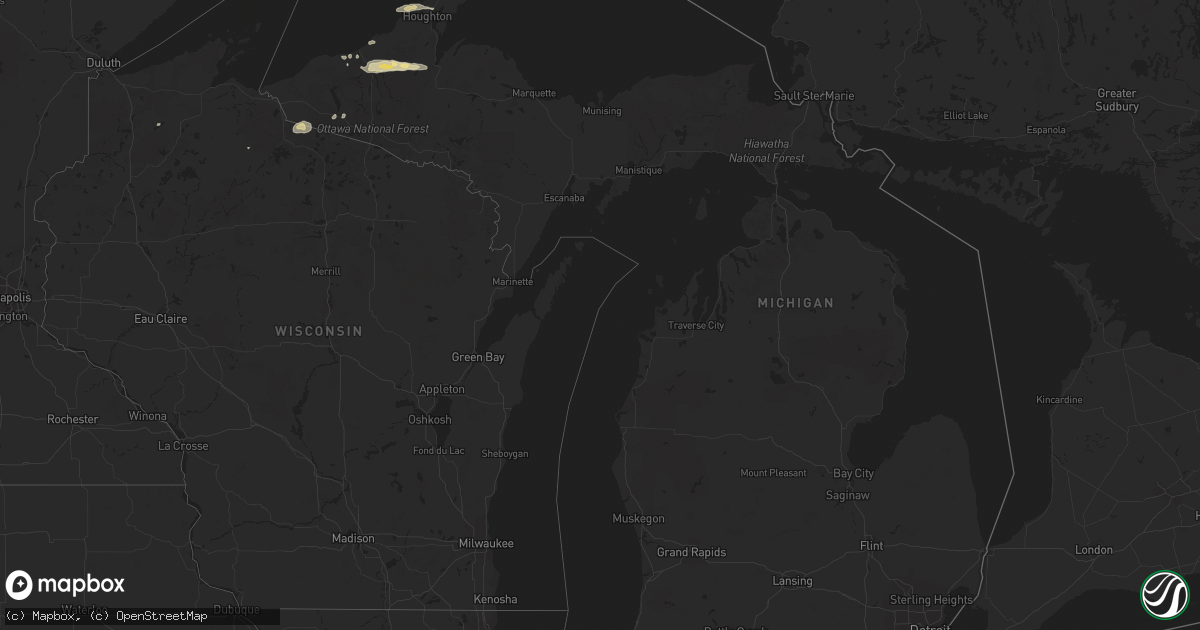
Hail Map in Michigan on June 10, 2017
Get this storm
June 10 map
$229
one time, instant access
Download today. No call, no setup
Keep the $229
Bought the map and want the full workflow? Apply the entire $229 to a subscription within 7 days. None of it is wasted.
Every map, not just this one
This buys you this map. Subscription and you get every map we run, in the markets you choose from a few cities to whole states to nationwide. Plus real-time alerts the moment a storm fires.
Contact data
Name, contact info, occupancy, even credit band for addresses in the footprint. You go from where it hit to who to call.
Become the source they trust
Unlimited branding weather history reports on demand. You already have the documented answer ready for the property owner, and you are the one who showed up with it.
Property data and RoofTrace estimates
Pull up any address you have got, its value and the exact code rules for that jurisdiction, straight from One Click Code. Then RoofTrace estimates the squares, pitch, and roof value, priced the way you price.
Storm reports in Michigan
Michigan
| Date | Description |
|---|---|
| 06/09/20179:15 PM CDT | Delayed report. Small trees blown over and branches broken off trees. |
| 06/09/20179:01 PM CDT | Delayed report from 6/10. Multiple trees down on forest highway 16 in ontonagon county. Time estimated from radar. |
| 06/09/20178:15 PM CDT | Tree down across m-26. Time estimated from radar. |
| 06/09/20178:07 PM CDT | Metal shed was flipped over by thunderstorm winds. Report received via social media. |
| 06/09/20178:07 PM CDT | Powerlines down in calumet. Time estimated from radar. |
| 06/09/20178:03 PM CDT | Trees down on powerlines and across m203. Time estimated from radar. |
All States Impacted by Hail Map on June 10, 2017
Cities Impacted by Hail Map on June 10, 2017
- Aneta, ND
- Atlantic Mine, MI
- Houghton, MI
- Calumet, MI
- Hancock, MI
- Holland, MN
- Pipestone, MN
- Murdo, SD
- Draper, SD
- Marietta, MN
- Revillo, SD
- Milbank, SD
- Gillette, WY
- Wasta, SD
- Lake Wilson, MN
- Edgerton, MN
- Woodstock, MN
- Elkton, SD
- Flandreau, SD
- Egan, SD
- Colman, SD
- Pelkie, MI
- Nisula, MI
- Ontonagon, MI
- Rockland, MI
- Mass City, MI
- Minneota, MN
- Boyd, MN
- Clarkfield, MN
- Sacred Heart, MN
- Maynard, MN
- Dawson, MN
- Lead, SD
- Newcastle, WY
- Nemo, SD
- Deadwood, SD
- Dell Rapids, SD
- Presho, SD
- Lake Benton, MN
- Howard, SD
- Aurora, SD
- Custer, SD
- Edgemont, SD
- Vivian, SD
- Sturgis, SD
- Granite Falls, MN
- Harrold, SD
- Lower Brule, SD
- Kennebec, SD
- Brookings, SD
- White, SD
- Rutland, SD
- Gary, SD
- Madison, MN
- Spearfish, SD
- Sundance, WY
- Beulah, WY
- Alpena, SD
- Wessington Springs, SD
- Woonsocket, SD
- Virgil, SD
- De Smet, SD
- Lake Preston, SD
- Mercer, WI
- Wakefield, MI
- Presque Isle, WI
- Marenisco, MI
- Madison, SD
- Nunda, SD
- Upton, WY
- Howes, SD
- White Owl, SD
- Arlington, SD
- Garden City, SD
- Vienna, SD
- Clark, SD
- Hitchcock, SD
- Saint Onge, SD
- Apopka, FL
- Kadoka, SD
- Bruce, SD
- Okaton, SD
- Osage, WY
- Montevideo, MN
- Odessa, MN
- Bellingham, MN
- Miller, SD
- Saint Lawrence, SD
- Wessington, SD
- Hayti, SD
- Brandt, SD
- Toronto, SD
- Astoria, SD
- Labolt, SD
- New Underwood, SD
- Wolsey, SD
- Huron, SD
- Highmore, SD
- Ree Heights, SD
- Stephan, SD
- Gann Valley, SD
- Chamberlain, SD
- Cavour, SD
- Fort Thompson, SD
- Iroquois, SD
- Fedora, SD
- Ruthton, MN
- Carthage, SD
- Wentworth, SD
- Artesian, SD
- Ramona, SD
- Winfred, SD
- Hill City, SD
- Mcville, ND
- Belvidere, SD
- Clear Lake, SD
- Box Elder, SD
- Taunton, MN
- Clara City, MN
- Union Center, SD
- Enning, SD
- Porter, MN
- Arco, MN
- Balaton, MN
- Russell, MN
- Lynd, MN
- Tyler, MN
- Marshall, MN
- Glidden, WI
- Goodwin, SD
- Strandburg, SD
- Northwood, ND
- Canby, MN
- Solon Springs, WI
- Gordon, WI
- Castlewood, SD
- Watertown, SD
- Rapid City, SD
- Bryant, SD
- Ivanhoe, MN
- Hanley Falls, MN
- Murdock, MN
- Echo, MN
- Wood Lake, MN
- Piedmont, SD
- Wall, SD
- Estelline, SD
- Black Hawk, SD
- Stockholm, SD
- Big Stone City, SD
- Midland, SD
- Willow Lake, SD
- Chester, SD
- Philip, SD
- Volga, SD
- Lake Norden, SD
- Erwin, SD
- Badger, SD
- Frankfort, SD
- Petersburg, ND
- Hendricks, MN
- Carpenter, SD
- Trent, SD
- Letcher, SD
- Chandler, MN
- Yale, SD
- Oldham, SD
- Garretson, SD
- Fort Pierre, SD
- Jasper, MN
- Fort McCoy, FL
- Greenland, MI
- Danvers, MN
- Henry, SD
- Kranzburg, SD
- Casselberry, FL
- Longwood, FL
- Pringle, SD


