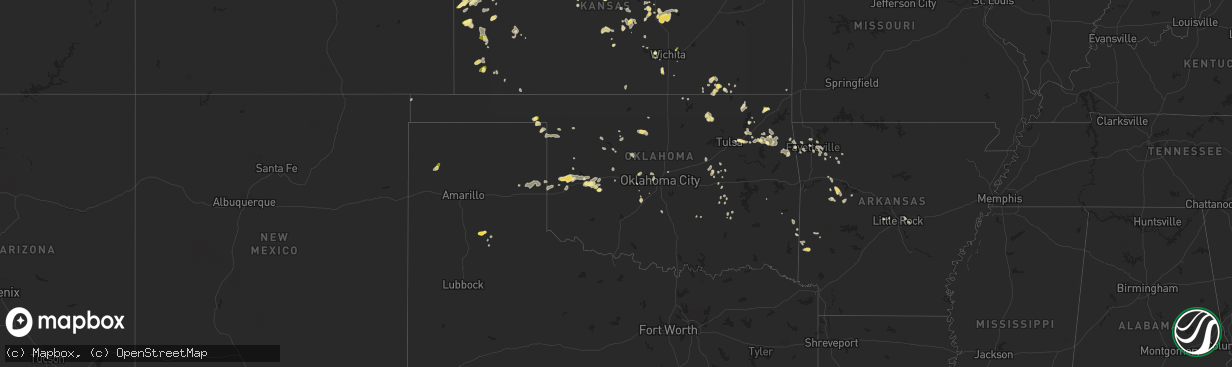
Hail Map in Oklahoma on June 9, 2023
The weather event in Oklahoma on June 9, 2023 includes Hail, Tornado, and Wind maps. 18 states and 474 cities were impacted and suffered possible damage. The total estimated number of properties impacted is 924.
Want more than just the map?
Turn this storm into a full workflow.
- Owner + property data so you know who to knock
- OnDemand branded weather history reports to win the "did we even have hail?" argument
- RoofTrace estimate so reps stop guessing numbers at the door
Bought this map? Upgrade within 7 days and we'll credit the $230. (10-15 min setup call)
Hail
Tornado
Wind
924
Estimated number of impacted properties by a 1.00" hail or larger0
Estimated number of impacted properties by a 1.75" hail or larger0
Estimated number of impacted properties by a 2.50" hail or largerStorm reports in Oklahoma
Oklahoma
| Date | Description |
|---|---|
| 06/09/20236:58 PM CDT | Report from mping: quarter |
| 06/09/20236:45 PM CDT | Power lines down on hwy 82 south of locust grove...tree blown over and took out power line. |
| 06/09/20236:29 PM CDT | Tree damage on hwy 51 between tahlequah and stilwell; location/time estimated by radar. |
| 06/09/20236:12 PM CDT | Tree damage sent in via twitter by storm tracker; location and time estimated by radar. |
| 06/09/20236:34 AM CDT | 2 inch tree branches broken on spring creek drive in the road. |
| 06/09/20232:55 AM CDT | A local report indicates 60 MPH wind near 5 SE Dover |
| 06/09/20232:50 AM CDT | A local report indicates 68 MPH wind near 5 SE Dover |
| 06/09/20232:35 AM CDT | 2-3 inch tree branches broken. Picture on twitter. |
| 06/09/20231:10 AM CDT | Ahead of the storms along the gust front. |
| 06/08/20239:00 PM CDT | Damage to building on port rd north of catoosa; time/location estimated by radar. |
| 06/08/20238:47 PM CDT | Report from mping: tree down over redbud road in catoosa time estimated by radar. |
| 06/08/20237:00 PM CDT | Measured at wynona mesonet. |
All States Impacted by Hail Map on June 9, 2023
Cities Impacted by Hail Map on June 9, 2023
- Hill City, SD
- Newcastle, NE
- Youngstown, FL
- Colby, KS
- Selden, KS
- Ewing, NE
- Chambers, NE
- Bartlett, NE
- Hoxie, KS
- Sopchoppy, FL
- Ericson, NE
- Colwich, KS
- Andale, KS
- Goddard, KS
- Garden Plain, KS
- Bassett, NE
- Long Pine, NE
- Greeley, NE
- Wolbach, NE
- Spalding, NE
- Saint Paul, NE
- Elba, NE
- Burwell, NE
- Oakley, KS
- Wellington, KS
- Scotia, NE
- North Loup, NE
- Primrose, NE
- Cedar Rapids, NE
- Ord, NE
- Rexford, KS
- Gove, KS
- Morland, KS
- Palco, KS
- Hill City, KS
- Plainville, KS
- Natoma, KS
- Arcadia, NE
- Woodston, KS
- Stockton, KS
- Miller, NE
- Mason City, NE
- Silverton, TX
- Benton, KS
- Hazard, NE
- Litchfield, NE
- Winona, KS
- Woodrow, CO
- Limon, CO
- Gaylord, KS
- Cedar, KS
- Kensington, KS
- Sterling, KS
- Hoisington, KS
- Claflin, KS
- Tribune, KS
- Genoa, CO
- Cozad, NE
- Rapid City, SD
- Lyons, KS
- Claremore, OK
- Comstock, NE
- Salina, OK
- Spavinaw, OK
- Bagley, MN
- Bliss, ID
- Levant, KS
- Loup City, NE
- Siloam Springs, AR
- Fayetteville, AR
- Holbrook, NE
- Hendley, NE
- Cambridge, NE
- Beaver City, NE
- Wilsonville, NE
- Norton, KS
- Valentine, NE
- Gothenburg, NE
- Witter, AR
- Broken Bow, NE
- Douglas, WY
- Panama City Beach, FL
- Panama City, FL
- Riverdale, NE
- Amherst, NE
- Kearney, NE
- Summers, AR
- Hyannis, NE
- Lingle, WY
- Lexington, NE
- Overton, NE
- Danville, AR
- Belleville, AR
- Carrabelle, FL
- Lanark Village, FL
- Ozark, AR
- San Jon, NM
- Pleasanton, NE
- Central City, NE
- Archer, NE
- Northwood, ND
- Larimore, ND
- Elm Creek, NE
- Orange Park, FL
- Jacksonville, FL
- Shawnee, WY
- Riverton, NE
- Bloomington, NE
- Smith Center, KS
- Port Barre, LA
- Arnaudville, LA
- Mcpherson, KS
- Calhan, CO
- Marquette, KS
- Kirwin, KS
- O'Brien, FL
- Branford, FL
- Palmer, NE
- Salol, MN
- Twin Falls, ID
- West Fork, AR
- American Falls, ID
- Elwood, NE
- Arapahoe, NE
- Edison, NE
- Hot Springs, SD
- Sargent, NE
- Colcord, OK
- Hettinger, ND
- Brewster, NE
- Biloxi, MS
- Saint Augustine, FL
- Hindsville, AR
- Elkins, AR
- Wesley, AR
- Old Town, FL
- Clayton, KS
- Norcatur, KS
- Jennings, KS
- Mena, AR
- Ansley, NE
- Orleans, NE
- Stamford, NE
- Lenora, KS
- Rudyard, MT
- Springdale, AR
- Chelsea, OK
- Walhalla, ND
- Cavalier, ND
- Neche, ND
- Rose, OK
- Dresden, KS
- Almena, KS
- Bunker Hill, KS
- Clearbrook, MN
- Eddyville, NE
- Paris, AR
- Saucier, MS
- Lindsborg, KS
- Inman, KS
- Torrington, WY
- Taylor, NE
- Clearwater, KS
- Grinnell, KS
- Wewahitchka, FL
- Grainfield, KS
- Anselmo, NE
- Brewster, KS
- Campbell, NE
- Kingston, AR
- Ponca, AR
- Chapman, NE
- Saint Libory, NE
- Combs, AR
- Huntsville, AR
- Hutchinson, KS
- Bruneau, ID
- Hoople, ND
- Bushton, KS
- Geneseo, KS
- Altus, AR
- Newell, SD
- Park, KS
- Bristol, FL
- Kanorado, KS
- Monument, KS
- Irvington, AL
- Middleburg, FL
- Prairie View, KS
- Fort White, FL
- Wood River, NE
- Watts, OK
- Westville, OK
- Gem, KS
- Alton, KS
- Lebanon, NE
- Pettigrew, AR
- Burlington, CO
- Prairie Grove, AR
- Lincoln, AR
- Cairo, NE
- Eastpoint, FL
- Russell, KS
- Aguilar, CO
- Hatton, ND
- Long Island, KS
- Perry, FL
- Trenton, FL
- Moreauville, LA
- East Palatka, FL
- Subiaco, AR
- Scranton, AR
- Wichita, KS
- Quinter, KS
- Magazine, AR
- Blue Mountain, AR
- Havana, AR
- Lake City, FL
- Gainesville, FL
- Middleboro, MA
- Stratton, CO
- Vona, CO
- Seibert, CO
- Sharon Springs, KS
- Weskan, KS
- Leoti, KS
- Karval, CO
- Hugo, CO
- Channing, TX
- Sedan, KS
- Syracuse, KS
- Kit Carson, CO
- Lakin, KS
- Dryden, TX
- Sheffield, TX
- Mertzon, TX
- San Angelo, TX
- Goodfellow Afb, TX
- Ulysses, KS
- Salina, KS
- Tescott, KS
- Brookville, KS
- Ozona, TX
- Wall, TX
- Vancourt, TX
- Eola, TX
- Canton, KS
- Galva, KS
- Laverne, OK
- Saint Francis, KS
- Tuthill, SD
- Hope, ND
- Coal Hill, AR
- Pretty Prairie, KS
- Haven, KS
- Arapahoe, CO
- Flagler, CO
- Clayton, NM
- Heartwell, NE
- Mcclusky, ND
- Belvidere, SD
- Long Valley, SD
- Hays, KS
- Victoria, KS
- Beloit, KS
- Locust Grove, OK
- Chouteau, OK
- Pryor, OK
- Holstein, NE
- Kenesaw, NE
- Glenrock, WY
- Rexburg, ID
- Esbon, KS
- Lebanon, KS
- Norris, SD
- Martin, SD
- Garden City, KS
- Jamestown, KS
- Concordia, KS
- La Crosse, KS
- St John, KS
- Lodgepole, NE
- Ipswich, SD
- Cedar Vale, KS
- Moline, KS
- Thedford, NE
- Catoosa, OK
- Tulsa, OK
- White River, SD
- Tahlequah, OK
- Fort Peck, MT
- Stafford, KS
- Peggs, OK
- Minneapolis, KS
- Minden, NE
- Bladen, NE
- Portis, KS
- Cody, NE
- Wynona, OK
- Kaycee, WY
- Alden, KS
- Brady, NE
- Merriman, NE
- Leonard, ND
- Proctor, OK
- Stilwell, OK
- Eldorado, TX
- Christoval, TX
- Scott City, KS
- Panacea, FL
- Fort Stockton, TX
- Vinita, OK
- Bluejacket, OK
- Harvard, ID
- Abilene, KS
- Solomon, KS
- Umpire, AR
- Grannis, AR
- Gillham, AR
- Smithville, OK
- Kansas, OK
- Moundridge, KS
- Caney, KS
- Glen Elder, KS
- Cheyenne Wells, CO
- Shelton, NE
- Ravenna, NE
- Newton, KS
- Goessel, KS
- Iraan, TX
- Eden, TX
- Hudson, KS
- Wallace, KS
- Menard, TX
- Inola, OK
- Kenton, OK
- Heavener, OK
- Hodgen, OK
- Kinta, OK
- Grand Island, NE
- Alda, NE
- Bennington, KS
- Melbourne, FL
- Grenville, NM
- Marienthal, KS
- Glasco, KS
- Jewell, KS
- Dardanelle, AR
- Independence, KS
- Wister, OK
- Princeton, ID
- Lockney, TX
- Wickes, AR
- Vandervoort, AR
- Cove, AR
- Pawhuska, OK
- Broken Arrow, OK
- Rose Hill, KS
- Okeechobee, FL
- Selby, SD
- Hillsboro, KS
- Lehigh, KS
- Geary, OK
- Brady, TX
- Mason, TX
- Ingalls, KS
- Jones, OK
- Moscow, KS
- Nickerson, KS
- Johnson, KS
- Redfield, SD
- Durham, KS
- Isabella, OK
- Follett, TX
- Seiling, OK
- Waldron, KS
- Marion, KS
- Tampa, KS
- Enid, OK
- Ringwood, OK
- Waukomis, OK
- Fairmont, OK
- Kingfisher, OK
- Plains, KS
- Long Beach, MS
- Ashton, SD
- Lahoma, OK
- Canton, OK
- New Cambria, KS
- Kremlin, OK
- Hunter, OK
- Liberal, KS
- Dripping Springs, TX
- Austin, TX
- Foss, OK
- Clinton, OK
- Bessie, OK
- Corn, OK
- Cordell, OK
- Lamar, OK
- Peru, KS
- Holdenville, OK
- Delaware, OK
- Lenapah, OK
- Johnson City, TX
- Newkirk, OK
- Saint Paul, AR
- El Reno, OK
- Paron, AR
- Little Rock, AR
- Tuttle, OK
- Longton, KS
- Erick, OK
- Sweetwater, OK
- Douglas, OK
- Scott, AR
- Bristow, OK
- Castle, OK
- Okemah, OK
- Okmulgee, OK
- Bethany, OK
- Oklahoma City, OK
- Arnett, OK
- Shattuck, OK
- Gage, OK
- Chester, OK
- Fairview, OK
- Pampa, TX
- Nowata, OK
- Butler, OK
- Llano, TX
- Elk City, OK
- Sayre, OK
- Cheyenne, OK
- Mcalester, OK
- Depew, OK
- Maysville, OK
- Wayne, OK
- Dustin, OK
- Niotaze, KS
- Watonga, OK
- Woodward, OK
- Shamrock, TX
- Wheeler, TX
- Beggs, OK
- Weleetka, OK
- Wetumka, OK
- Driftwood, TX
- Leedey, OK
- Baxter Springs, KS
- Riverton, KS
- Winslow, AR
- North Little Rock, AR
- Chickasha, OK
- Amber, OK
- Oxford, KS
- Ada, OK
- Loyal, OK
- Hulbert, OK
- Fredericksburg, TX
- Yukon, OK
- Okeene, OK
- Hammon, OK
- Buda, TX
- Stuart, OK
- Weatherford, OK
- Spicewood, TX
- Round Mountain, TX
- Willow City, TX
- Hydro, OK
- Burnet, TX
- Fargo, OK
- Union City, OK
- Minco, OK


