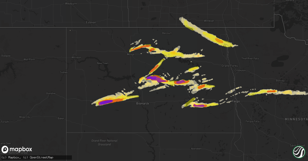
Hail Map in North Dakota on June 9, 2017
Get this storm
June 9 map
$229
one time, instant access
Download today. No call, no setup
Keep the $229
Bought the map and want the full workflow? Apply the entire $229 to a subscription within 7 days. None of it is wasted.
Every map, not just this one
This buys you this map. Subscription and you get every map we run, in the markets you choose from a few cities to whole states to nationwide. Plus real-time alerts the moment a storm fires.
Contact data
Name, contact info, occupancy, even credit band for addresses in the footprint. You go from where it hit to who to call.
Become the source they trust
Unlimited branding weather history reports on demand. You already have the documented answer ready for the property owner, and you are the one who showed up with it.
Property data and RoofTrace estimates
Pull up any address you have got, its value and the exact code rules for that jurisdiction, straight from One Click Code. Then RoofTrace estimates the squares, pitch, and roof value, priced the way you price.
Storm reports in North Dakota
North Dakota
| Date | Description |
|---|---|
| 06/09/20176:53 PM CDT | Small tree limbs ripped along highway 2. |
| 06/09/20176:52 PM CDT | A local report indicates 1.00 inch wind near 1 NW OLGA |
| 06/09/20176:45 PM CDT | A tornado was partially engulfed in downburst winds and hail as it tracked for nearly 20 miles to around 3 miles s of mountain by 715 pm cdt. Large wooden power poles w |
| 06/09/20176:45 PM CDT | 1.17 inches of rain fell within 10 minutes. Largest hail was pea size. |
| 06/09/20176:40 PM CDT | A local report indicates 104 MPH wind near 3 W RUGBY |
| 06/09/20176:37 PM CDT | Peak wind measured at the ndawn station east of town. |
| 06/09/20176:37 PM CDT | A local report indicates 1.25 inch wind near 4 W HURDSFIELD |
| 06/09/20176:37 PM CDT | Dime sized hail as well. |
| 06/09/20176:30 PM CDT | Pea size hail and heavy rain. |
| 06/09/20176:27 PM CDT | A weak tornado tracked to the southeast for around 1.25 miles and lifted by 629 pm cdt. The tornado blew the doors off a seed company elevator and spread door and roof |
| 06/09/20176:27 PM CDT | A local report indicates 85 MPH wind near 3 E TOWNER |
| 06/09/20176:20 PM CDT | Numerous large 4 to 8 inch branches broken down in the wind at farmstead. |
| 06/09/20176:17 PM CDT | A local report indicates 2.00 inch wind near 5 N DENHOFF |
| 06/09/20176:10 PM CDT | A local report indicates 1.00 inch wind near BAKER |
| 06/09/20176:09 PM CDT | A tornado engulfed in downburst winds and hail tracked for nearly two miles ending around 3.5 miles ese of wales by 612 pm cdt. The tornado snapped numerous tree limbs |
| 06/09/20175:46 PM CDT | Peak wind measured by an agricultural weather station at the canadian border. Nearby corn and small grain fields were stripped by wind driven hail. Evergreen and poplar |
| 06/09/20175:25 PM CDT | Posted on facebook with a picture. |
| 06/09/20175:12 PM CDT | Reported at pickerdville. Time estimated by radar. |
| 06/09/20174:55 PM CDT | Half dollar size hail also damage reported to vehicles. |
| 06/09/20174:45 PM CDT | A local report indicates 1.00 inch wind near TURTLE LAKE |
| 06/09/20174:42 PM CDT | Time estimated from radar. |
| 06/09/20177:24 AM CDT | Reported 3 ene baker |
| 06/09/20176:31 AM CDT | Peak winds measured at a personal weather station. |
| 06/09/20175:43 AM CDT | Peak winds measured at the ndawn station near pekin. |
| 06/09/20175:31 AM CDT | A local report indicates 61 MPH wind near 1 W DEVILS LAKE |
| 06/09/20175:28 AM CDT | Peak winds measured at the devils lake rwis station. |
| 06/09/20175:27 AM CDT | Peak winds measured at the ndawn station 8n mchenry. |
| 06/09/20174:50 AM CDT | Measured mesonet thunderstorm wind gust. |
| 06/09/20173:54 AM CDT | A local report indicates 73 MPH wind near 1 NNW WASHBURN |
| 06/09/20173:40 AM CDT | Duration of event was about 10 minutes. |
| 06/09/20173:40 AM CDT | A local report indicates 60 MPH wind near HANNOVER |
| 06/09/20171:48 AM CDT | Dime to quarter size hail reported in center. |
| 06/09/20171:45 AM CDT | Estimates wind gusts 60 to 70 mph. The duration of the tstm wnd gst event was 5 minutes. |
| 06/09/20171:40 AM CDT | Wind gusted to 53 mph. The duration of the hail event was 5 minutes. |
| 06/09/20171:30 AM CDT | Hail sizes estimated to range between one and two inches in diameter. The home suffered paint and window damage. The metal roof on the barn had large dents. Crop damage |
| 06/09/20171:11 AM CDT | Baseball size hail broke car windshields between mile marker 90 and 91 on interstate 94 . |
| 06/09/20171:10 AM CDT | Winds gusting to 70 mph. The duration of the hail event was 5 minutes. |
| 06/09/20171:06 AM CDT | Public report relayed by media. |
| 06/09/20171:03 AM CDT | Quarter to golf ball size hail in hebron. |
| 06/09/201712:45 AM CDT | Resident lost 5 windows due to the hail. |
| 06/09/201712:40 AM CDT | Wind driven hail caused damage to the home... Barns... And vehicles. Multiple windows were shattered on the home causing damage inside. Wind driven rain was forced thro |
| 06/08/201711:10 PM CDT | A local report indicates 1.00 inch wind near 1 WSW GARDNER |
| 06/08/201710:48 PM CDT | Hail from dime to quarter sized for about 5 minutes. |
| 06/08/201710:40 PM CDT | Multiple vehicles off road on i94 which is closed in this region. Exact cause presently unknown. |
| 06/08/201710:35 PM CDT | Quarter to half dollar sized hail fell in very heavy rain. |
| 06/08/201710:15 PM CDT | Multiple vehicles off road on i94 which is closed in this region. Exact cause presently unknown. |
| 06/08/201710:15 PM CDT | A chicken coop was destroyed and two large evergreens were blown down. |
| 06/08/201710:10 PM CDT | A steel grain bin was blown off its foundatiom and tumbled for a quarter of a mile. |
| 06/08/201710:05 PM CDT | A local report indicates 1.50 inch wind near 7 N LITCHVILLE |
| 06/08/201710:00 PM CDT | A local report indicates 1.00 inch wind near 5 WNW HOPE |
| 06/08/20179:55 PM CDT | A local report indicates 1.00 inch wind near 5 WNW HOPE |
| 06/08/20179:40 PM CDT | A local report indicates 1.00 inch wind near 2 ESE HANNAFORD |
| 06/08/20179:39 PM CDT | Blowing dust in outflow. |
| 06/08/20179:35 PM CDT | A local report indicates 1.75 inch wind near HANNAFORD |
| 06/08/20179:34 PM CDT | Hailed from 934 to 949 pm |
| 06/08/20179:32 PM CDT | Report of touchdown southwest of walum viewed by spotters northeast of wimbledon and also by spotters north of dazey. A persistent wallcloud structure with funnel-like |
| 06/08/20179:32 PM CDT | Report of touchdown west of walum viewed by spotters northeast of wimbledon and also spotters north of dazey. |
| 06/08/20179:30 PM CDT | Golfball sized hail the largest... Lots of quarter sized hail. Very little rain... Perhaps a hundredth of an inch. |
| 06/08/20179:24 PM CDT | Report from social media. |
| 06/08/20179:01 PM CDT | Late report from friday evening. |
| 06/08/20178:50 PM CDT | Numerous tree branches down... One large tree uprooted |
| 06/08/20178:40 PM CDT | Dime to quarter sized hail covered the ground. |
| 06/08/20178:40 PM CDT | Lots of quarter to golf ball sized hail. |
| 06/08/20178:40 PM CDT | A local report indicates 1.00 inch wind near 2 ESE HANNAFORD |
| 06/08/20178:38 PM CDT | A local report indicates 1.00 inch wind near JAMESTOWN |
| 06/08/20178:35 PM CDT | A local report indicates 1.75 inch wind near HANNAFORD |
| 06/08/20178:35 PM CDT | A local report indicates 1.50 inch wind near 2 S HAMAR |
| 06/08/20178:35 PM CDT | Picture posted on facebook. |
| 06/08/20178:31 PM CDT | Peak winds measured at the crary ndawn station. |
| 06/08/20178:29 PM CDT | Peak winds measured at the crary ndawn station. |
| 06/08/20178:29 PM CDT | A weak tornado track to east for nearly 3 miles across far southern eddy township ending about 7 sw of hamar by 833 pm cdt. This tornado cross the southern end on lake |
| 06/08/20178:28 PM CDT | Dvl rwis |
| 06/08/20178:27 PM CDT | Touchdown noted by observer near vining oil...looking north. |
| 06/08/20178:10 PM CDT | Picture posted on facebook. Event time was corrected from 8:35 pm to 8:10 pm. |
| 06/08/20178:10 PM CDT | Numerous large poplar... Ash... And cottonwood trees were snapped or blown down in shelter belts and farmsteads across st. Andrews and northern acton townships. Peak wi |
| 06/08/20178:10 PM CDT | A steel grain bin was blown off its foundatiom and tumbled for a quarter of a mile. |
| 06/08/20178:05 PM CDT | A local report indicates 1.75 inch wind near CARRINGTON |
| 06/08/20178:00 PM CDT | Multiple trees have been downed. |
| 06/08/20178:00 PM CDT | Hail storm lasted for about 6 minutes. |
| 06/08/20178:00 PM CDT | Davis measurement. |
| 06/08/20177:52 PM CDT | Extensive tree damage extending from eastern farmington into martin township. Numerous large poplar... Ash... And cottonwoods were snapped in field and farmstead shelte |
| 06/08/20177:50 PM CDT | A local report indicates 1.50 inch wind near 1 S ST. THOMAS |
| 06/08/20177:45 PM CDT | Very strong winds and very heavy rain with dime to nickel sized hail. |
| 06/08/20177:40 PM CDT | Peak winds measured at the st. Thomas ndawn station. |
| 06/08/20177:35 PM CDT | A local report indicates 2.00 inch wind near 1 E LEEDS |
| 06/08/20177:34 PM CDT | A tornado tracked eastward over largely open country for nearly 2 miles to around 4 nnw of minnewaukan by around 737 pm cdt. The ground swirl of this tornado was videoe |
| 06/08/20177:24 PM CDT | Peak winds measured at a personal weather station. Numerous oak... Poplar... And pine trees snapped in shelter belts across eldora and crystal townships. |
| 06/08/20177:24 PM CDT | Reported 3 ene baker |
| 06/08/20177:20 PM CDT | Large pine tree blown down. |
| 06/08/20177:20 PM CDT | Lasted from around 720 pm to 735 pm. |
| 06/08/20177:19 PM CDT | Measured on mobile mesonet equipment. |
| 06/08/20177:19 PM CDT | Measured on mobile mesonet equipment. |
| 06/08/20177:18 PM CDT | Brief touchdown noted west of harlow. |
| 06/08/20177:15 PM CDT | Several roofs blown off buildings. |
| 06/08/20177:15 PM CDT | Extensive damage in milton. Unquantified at this time. |
| 06/08/20177:15 PM CDT | Several buildings down...type and extent of damage unknown at present. |
| 06/08/20177:10 PM CDT | Numerous large tree branches and limbs broken down around across much of thingvalla township. Some trees snapped. Sheet metal roofing and shingles blown off buildings i |
| 06/08/20177:08 PM CDT | A tornado tracked in an east-southeast direction along a roughly 8 mile intermittent track to around 2 wnw of harlow by 720 pm cdt. This tornado and corresponding rear |
| 06/08/20177:02 PM CDT | A local report indicates 1.00 inch wind near CONCRETE |
| 06/08/20177:00 PM CDT | Report from early friday evening of large hail in chaseley... Nd. |
| 06/08/20177:00 PM CDT | Report from a trained spotter that friends of his were travelling through rugby around 7pm cdt... And experienced tornadic like winds... Approximately 80 mph. |
| 06/08/20177:00 PM CDT | Large portions of alma and east alma townships were stripped of small grain and bean crops by extreme downburst winds and wind driven hail. |
All States Impacted by Hail Map on June 9, 2017
Cities Impacted by Hail Map on June 9, 2017
- Lakota, ND
- Brocket, ND
- Crary, ND
- Hebron, ND
- Stanton, ND
- Center, ND
- Beulah, ND
- New Salem, ND
- Hazen, ND
- Glen Ullin, ND
- Taylor, ND
- Gladstone, ND
- Dickinson, ND
- Richardton, ND
- South Heart, ND
- Zap, ND
- Mandan, ND
- Courtenay, ND
- Deering, ND
- Glenburn, ND
- Minot, ND
- Remer, MN
- Walker, MN
- Cass Lake, MN
- Akeley, MN
- Laporte, MN
- Longville, MN
- Warba, MN
- Ada, MN
- Hendrum, MN
- Saint Thomas, ND
- Crystal, ND
- Johnson City, TX
- Harwood, ND
- Grandin, ND
- Perley, MN
- Gardner, ND
- Argusville, ND
- Arthur, ND
- Hunter, ND
- Anamoose, ND
- Wimberley, TX
- Dripping Springs, TX
- Cavalier, ND
- Walhalla, ND
- Milton, ND
- Edinburg, ND
- Langdon, ND
- Mountain, ND
- Hannah, ND
- Stephen, MN
- Osnabrock, ND
- Grafton, ND
- Drayton, ND
- Wales, ND
- Kennedy, MN
- Hoople, ND
- Hensel, ND
- Harvey, ND
- Spiritwood, ND
- Leeds, ND
- Chaseley, ND
- Hurdsfield, ND
- Bowdon, ND
- Grace City, ND
- Wing, ND
- Sykeston, ND
- Washburn, ND
- Glenfield, ND
- Mcclusky, ND
- Kensal, ND
- Goodrich, ND
- Regan, ND
- Denhoff, ND
- Wilton, ND
- Carrington, ND
- Turtle Lake, ND
- Mercer, ND
- Upham, ND
- Newburg, ND
- Baldwin, ND
- Twin Valley, MN
- Luverne, ND
- Cooperstown, ND
- Hannaford, ND
- Wimbledon, ND
- Knox, ND
- Towner, ND
- Rugby, ND
- Esmond, ND
- Penn, ND
- Minnewaukan, ND
- Bantry, ND
- Devils Lake, ND
- Churchs Ferry, ND
- York, ND
- White Earth, MN
- Ogema, MN
- Naytahwaush, MN
- Park Rapids, MN
- Ponsford, MN
- Waubun, MN
- Bagley, MN
- Hope, ND
- Dazey, ND
- Sutton, ND
- Montpelier, ND
- Ypsilanti, ND
- Litchville, ND
- Marion, ND
- Jamestown, ND
- Kathryn, ND
- New Rockford, ND
- Pekin, ND
- Warwick, ND
- Tolna, ND
- Junction, TX
- Binford, ND
- Sheyenne, ND
- Granville, ND
- Hibbing, MN
- Surrey, ND
- Martin, ND
- Drake, ND
- Casselton, ND
- Sanborn, ND
- Mason, TX
- Cleveland, ND
- Driftwood, TX
- Round Mountain, TX
- Lawton, ND
- Nevis, MN
- Mapleton, ND
- Maxbass, ND
- Fessenden, ND
- Cando, ND
- West Fargo, ND
- Georgetown, MN
- San Marcos, TX
- Willow City, ND
- Tuttle, ND
- Robinson, ND
- Cathay, ND
- Finley, ND
- Borup, MN
- Hill City, MN
- Grand Rapids, MN
- Spicewood, TX
- Marble Falls, TX
- Ulen, MN
- Fingal, ND
- Valley City, ND
- Wheatland, ND
- Buffalo, ND
- Lake George, MN
- Federal Dam, MN
- Lake Park, MN
- Butte, ND
- Woodworth, ND
- Mchenry, ND
- Oriska, ND
- Tower City, ND
- Aurora, MN
- Makinen, MN
- Fortuna, ND
- Finland, MN
- Underwood, ND
- Goodland, MN
- Deer River, MN
- Hitterdal, MN
- Hawley, MN
- Aneta, ND
- Buchanan, ND
- Adams, ND
- Jud, ND
- Swan River, MN
- Callaway, MN


