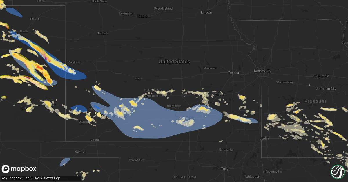
Hail Map in Kansas on June 8, 2024
Get this storm
June 8 map
$229
one time, instant access
Download today. No call, no setup
Keep the $229
Bought the map and want the full workflow? Apply the entire $229 to a subscription within 7 days. None of it is wasted.
Every map, not just this one
This buys you this map. Subscription and you get every map we run, in the markets you choose from a few cities to whole states to nationwide. Plus real-time alerts the moment a storm fires.
Contact data
Name, contact info, occupancy, even credit band for addresses in the footprint. You go from where it hit to who to call.
Become the source they trust
Unlimited branding weather history reports on demand. You already have the documented answer ready for the property owner, and you are the one who showed up with it.
Property data and RoofTrace estimates
Pull up any address you have got, its value and the exact code rules for that jurisdiction, straight from One Click Code. Then RoofTrace estimates the squares, pitch, and roof value, priced the way you price.
Storm reports in Kansas
Kansas
| Date | Description |
|---|---|
| 06/08/20243:24 AM CDT | A local report indicates 62 MPH wind near Chanute |
| 06/08/20243:21 AM CDT | Report from mping: 3-inch tree limbs broken; power poles broken. |
| 06/08/20243:12 AM CDT | Report from mping: trees uprooted or snapped; roof blown off. |
| 06/08/20242:50 AM CDT | Tree limbs down. |
| 06/08/20242:45 AM CDT | Power lines down at greenwich & douglas. |
| 06/08/20242:45 AM CDT | Reported by off-duty mcconnell afb meteorologist. |
| 06/08/20242:39 AM CDT | 12 inch diameter limb/branches broken... Picture on twitter. |
| 06/08/20242:39 AM CDT | Several large trees and tree limbs down. |
| 06/08/20242:38 AM CDT | A local report indicates 66 MPH wind near Wichita Eisenhower Airp |
| 06/08/20242:35 AM CDT | Report from mping: trees uprooted or snapped;. |
| 06/08/20242:30 AM CDT | Large tree limbs down and no power in parts of town. |
| 06/08/20242:25 AM CDT | A local report indicates 67 MPH wind near 6 NNW Viola |
| 06/08/20242:23 AM CDT | A local report indicates 60 MPH wind near Viola |
| 06/08/20242:22 AM CDT | A local report indicates 62 MPH wind near 6 S Clearwater |
| 06/08/20242:03 AM CDT | Report from mping: trees uprooted or snapped; roof blown off. |
| 06/08/20242:02 AM CDT | Rain blowing horizontal. Visibility reduced to about 30 ft. |
| 06/08/20241:20 AM CDT | A local report indicates 60 MPH wind near 2 SE Medicine Lodge |
| 06/08/20241:20 AM CDT | A local report indicates 65 MPH wind near Kinsley |
| 06/08/202412:56 AM CDT | Report from mping: 1-inch tree limbs broken; shingles blown off. |
| 06/08/202412:55 AM CDT | Awos station kptt pratt indust. |
| 06/08/202412:51 AM CDT | Public pictures of a tree uprooted. |
| 06/08/202412:45 AM CDT | A local report indicates 65 MPH wind near Coats |
| 06/08/202412:45 AM CDT | Picture on social media of a tree uprooted. |
| 06/08/202412:38 AM CDT | A local report indicates 60 MPH wind near Pawnee Rock |
| 06/08/202412:24 AM CDT | Report from mping: quarter |
| 06/08/202412:20 AM CDT | Report from mping: 1-inch tree limbs broken. |
| 06/08/202412:10 AM CDT | Sixty to 65 mph wind gust was reported. |
| 06/08/202412:03 AM CDT | Mping report of wind damage trees uprooted/snapped. |
| 06/07/202411:58 PM CDT | Report from mping: 1-inch tree limbs broken; shingles blown off. |
| 06/07/202411:45 PM CDT | Mesonet station dw9907 bloom. |
| 06/07/202411:40 PM CDT | A local report indicates 70 MPH wind near 3 NW Ft. Dodge |
| 06/07/202411:05 PM CDT | A local report indicates 65 MPH wind near Cimarron |
| 06/07/202410:57 PM CDT | Mesonet station ur350 kismws. |
| 06/07/202410:50 PM CDT | Social media pictures of a blown down shed... Damage to metal fencing... And snapping of large tree limbs. |
| 06/07/202410:50 PM CDT | A local report indicates 68 MPH wind near 10 SE Satanta |
| 06/07/202410:40 PM CDT | Corrects previous tstm wnd gst report from 10 nw kalvesta. Corrects previous tstm wnd gst report from 5 sw alamota. |
| 06/07/202410:40 PM CDT | Corrects previous tstm wnd gst report from 5 sw alamota. |
| 06/07/202410:40 PM CDT | A local report indicates 93 MPH wind near 5 SW Alamota |
| 06/07/202410:32 PM CDT | Shingles blown off of roofs. |
| 06/07/202410:32 PM CDT | A local report indicates 72 MPH wind near 4 NW Pierceville |
| 06/07/202410:31 PM CDT | 3 inch diameter branches down. |
| 06/07/202410:22 PM CDT | Report from mping: 1-inch tree limbs broken; shingles blown off. |
| 06/07/202410:18 PM CDT | A local report indicates 80 MPH wind near 3 N Garden City |
| 06/07/202410:15 PM CDT | A local report indicates 2.50 inch wind near 8 NE Hickok |
| 06/07/202410:15 PM CDT | The emergency manager reported 28 high voltage transmission poles blown down. Time was estimated by radar. |
| 06/07/202410:12 PM CDT | Report from mping: 3-inch tree limbs broken; power poles broken. |
| 06/07/20249:57 PM CDT | A local report indicates 3.00 inch wind near 11 S Lakin |
| 06/07/20249:55 PM CDT | A local report indicates 58 MPH wind near 1 E Scott City |
| 06/07/20249:38 PM CDT | A local report indicates 1.75 inch wind near 5 N Scott City |
| 06/07/20249:35 PM CDT | A local report indicates 67 MPH wind near Johnson City |
| 06/07/20249:30 PM CDT | A local report indicates 71 MPH wind near Syracuse |
| 06/07/20248:58 PM CDT | Dispatch reports 65 mph gusts with the storms. |
| 06/07/20248:54 PM CDT | Sixty to 70 mph thunderstorm wind gusts were estimated. |
| 06/07/20248:50 PM CDT | A local report indicates 1.25 inch wind near 12 N Sharon Springs |
| 06/07/20248:10 PM CDT | Public report of 70 mph estimated winds and pea sized hail. |
All States Impacted by Hail Map on June 8, 2024
Cities Impacted by Hail Map on June 8, 2024
- Gardiner, ME
- Jefferson, ME
- Alna, ME
- Newcastle, ME
- Cheyenne, WY
- Burns, WY
- Carpenter, WY
- Hillsdale, WY
- Red Feather Lakes, CO
- Bellvue, CO
- Nobleboro, ME
- Livermore, CO
- Bennett, CO
- Strasburg, CO
- Elizabeth, CO
- Kiowa, CO
- Peyton, CO
- Byers, CO
- Deer Trail, CO
- Calhan, CO
- Nunn, CO
- Grover, CO
- Carr, CO
- Arimo, ID
- Lava Hot Springs, ID
- Yoder, CO
- Rush, CO
- Gill, CO
- Downey, ID
- Greeley, CO
- Eaton, CO
- Fort Sumner, NM
- Briggsdale, CO
- Ramah, CO
- Rifle, CO
- Galeton, CO
- Hereford, CO
- White Deer, TX
- New Raymer, CO
- Kersey, CO
- Keenesburg, CO
- Skellytown, TX
- Woodrow, CO
- Genoa, CO
- Roggen, CO
- Pueblo, CO
- Boone, CO
- Stoneham, CO
- Orchard, CO
- Wiggins, CO
- Weldona, CO
- Fort Morgan, CO
- Arriba, CO
- Limon, CO
- Hugo, CO
- Matheson, CO
- Flagler, CO
- Stratford, TX
- Manzanola, CO
- Brush, CO
- Akron, CO
- Dalhart, TX
- Olney Springs, CO
- Ordway, CO
- Mills, WY
- Casper, WY
- Lindon, CO
- Seibert, CO
- Karval, CO
- Sugar City, CO
- Tulelake, CA
- Agate, CO
- Floyd, NM
- Otis, CO
- Vona, CO
- Rocky Ford, CO
- Anton, CO
- Kit Carson, CO
- Elida, NM
- La Junta, CO
- Sunray, TX
- Stinnett, TX
- Portales, NM
- Humansville, MO
- Melrose, NM
- Cheraw, CO
- Haswell, CO
- Cope, CO
- Yuma, CO
- Elbert, CO
- Flemington, MO
- Bolivar, MO
- Joes, CO
- Clovis, NM
- Dunnegan, MO
- Polk, MO
- Las Animas, CO
- Lebanon, MO
- Stoutland, MO
- Wheatland, MO
- Hermitage, MO
- Pittsburg, MO
- Half Way, MO
- Macdoel, CA
- Eads, CO
- Stratton, CO
- Plato, MO
- Bucyrus, MO
- Huggins, MO
- Preston, MO
- Simla, CO
- Hasty, CO
- Hartley, TX
- Buffalo, MO
- Bethune, CO
- Laquey, MO
- Falcon, MO
- McClave, CO
- Morse, TX
- Elkland, MO
- Licking, MO
- Success, MO
- Roby, MO
- Friona, TX
- Richland, MO
- Burlington, CO
- Wiley, CO
- Lamar, CO
- Kirk, CO
- Houston, MO
- Mountain Grove, MO
- Graff, MO
- Greenfield, MO
- Kanorado, KS
- Yukon, MO
- Fair Grove, MO
- Solo, MO
- Cheyenne Wells, CO
- Hartville, MO
- Fordland, MO
- Rogersville, MO
- Dadeville, MO
- Perryton, TX
- Strafford, MO
- Spearman, TX
- Walnut Grove, MO
- Everton, MO
- Springfield, MO
- Norwood, MO
- Marshfield, MO
- Summersville, MO
- Eunice, MO
- Holly, CO
- Wild Horse, CO
- Goodland, KS
- Sharon Springs, KS
- Weskan, KS
- Arapahoe, CO
- Wallace, KS
- Eminence, MO
- Elk Creek, MO
- Steelville, MO
- Potosi, MO
- Princeton, OR
- Granada, CO
- Dorris, CA
- Tribune, KS
- Cabool, MO
- Winona, KS
- Syracuse, KS
- Diamond, OR
- Coolidge, KS
- Scott City, KS
- Leoti, KS
- Cuba, MO
- Saint James, MO
- Niangua, MO
- Willard, MO
- Seymour, MO
- Ash Grove, MO
- Manter, KS
- Vanzant, MO
- Willow Springs, MO
- Ironton, MO
- Oronogo, MO
- Mindenmines, MO
- Liberal, MO
- Kendall, KS
- Birch Tree, MO
- Florence, CO
- Wetmore, CO
- Drury, MO
- Ava, MO
- Jasper, MO
- Winona, MO
- Cherryville, MO
- Lakin, KS
- Lamar, MO
- Bismarck, MO
- Park Hills, MO
- Fredericktown, MO
- Coal Creek, CO
- Ulysses, KS
- Garden City, KS
- Alton, MO
- Johnson, KS
- Bixby, MO
- Bois D Arc, MO
- Healy, KS
- Dora, MO
- Grinnell, KS
- Oakley, KS
- Marienthal, KS
- Fremont, MO
- Fowler, CO
- Mansfield, MO
- Black, MO
- Lesterville, MO
- Pleasant Hope, MO
- Doniphan, MO
- Centerville, MO
- Penrose, CO
- Brighton, MO
- Pierceville, KS
- Ingalls, KS
- Sublette, KS
- Larned, KS
- Amarillo, TX
- Satanta, KS
- Ellington, MO
- Pomona, MO
- West Plains, MO
- Pottersville, MO
- Couch, MO
- Deerfield, KS
- Holcomb, KS
- Cimarron, KS
- Dighton, KS
- Beeler, KS
- Ness City, KS
- Jetmore, KS
- Hanston, KS
- Long Lane, MO
- Vulcan, MO
- Piedmont, MO
- Ensign, KS
- Wright, KS
- Dodge City, KS
- Mammoth Spring, AR
- Hardy, AR
- Burdett, KS
- Fairdealing, MO
- Harviell, MO
- Lincolnville, KS
- Marion, KS
- Tampa, KS
- Ravenden, AR
- Koshkonong, MO
- Republic, MO
- Phillipsburg, MO
- Burns, OR
- Des Arc, MO
- Patterson, MO
- Greenville, MO
- Hillsboro, KS
- Success, AR
- Maynard, AR
- Poplar Bluff, MO
- Neelyville, MO
- Williamsville, MO
- Williford, AR
- Durham, KS
- Strong City, KS
- Ravenden Springs, AR
- Lyons, KS
- Bushton, KS
- Billings, MO
- Clever, MO
- Kinsley, KS
- Albert, KS
- Otis, KS
- Biggers, AR
- Corning, AR
- Spearville, KS
- Ford, KS
- Offerle, KS
- Nixa, MO
- Copeland, KS
- Peach Orchard, AR
- Ellinwood, KS
- Ash Flat, AR
- Evening Shade, AR
- Black Rock, AR
- Imboden, AR
- Wappapello, MO
- Cherokee Village, AR
- Great Bend, KS
- Paragould, AR
- Chase, KS
- Smithville, AR
- Little River, KS
- Hoisington, KS
- Geneseo, KS
- Montezuma, KS
- Grovespring, MO
- Marmaduke, AR
- Garfield, KS
- Rozel, KS
- Poughkeepsie, AR
- Puxico, MO
- Dudley, MO
- Fisk, MO
- Claflin, KS
- Conway, MO
- Galva, KS
- Lafe, AR
- Beech Grove, AR
- Elmdale, KS
- Emporia, KS
- Minneola, KS
- Fowler, KS
- Ashland, KS
- Bucklin, KS
- Greensburg, KS
- Lewis, KS
- Mullinville, KS
- Powhatan, AR
- Squires, MO
- Ozark, MO
- Wasola, MO
- Stockton, MO
- Mount Vernon, MO
- Monette, AR
- Haviland, KS
- Cardwell, MO
- Noble, MO
- Leachville, AR
- Arbyrd, MO
- Cedar Point, KS
- Brookline, MO
- Sheldon, MO
- Bronaugh, MO
- Rush Center, KS
- Windyville, MO
- Thornfield, MO
- Pawnee Rock, KS
- Aurora, MO
- Waynesville, MO
- Gainesville, MO
- Wilmore, KS
- Coldwater, KS
- Milo, MO
- Burns, KS
- Manila, AR
- Cottonwood Falls, KS
- Ridgely, TN
- Caulfield, MO
- Miller, MO
- Brixey, MO
- Pratt, KS
- Kiowa, KS
- Hardtner, KS
- Medicine Lodge, KS
- Protection, KS
- Sun City, KS
- Coats, KS
- Lake City, KS
- Sawyer, KS
- Iuka, KS
- Byers, KS
- St John, KS
- Macksville, KS
- Belpre, KS
- Stafford, KS
- Hudson, KS
- Turon, KS
- Obion, TN
- Hornbeak, TN
- Nevada, MO
- Etowah, AR
- Clarkridge, AR
- Tecumseh, MO
- Lindsborg, KS
- Gypsum, KS
- Marquette, KS
- Canton, KS
- Marionville, MO
- El Dorado Springs, MO
- Bragg City, MO
- Caruthersville, MO
- Hayti, MO
- Trimble, TN
- Kenton, TN
- Newbern, TN
- Dyersburg, TN
- Rutherford, TN
- Finley, TN
- Trenton, TN
- Lenox, TN
- Friendship, TN
- Halls, TN
- Dyer, TN
- Garnett, KS
- Richmond, KS
- Sturkie, AR
- Salem, AR
- Potwin, KS
- El Dorado, KS
- Gamaliel, AR
- Bakersfield, MO
- Gepp, AR
- Henderson, AR
- Broseley, MO
- Isabel, KS
- Cunningham, KS
- Sylvia, KS
- Waldron, KS
- Anthony, KS
- Zenda, KS
- Sharon, KS
- Nashville, KS
- Hazelton, KS
- Spivey, KS
- Attica, KS
- Williamsburg, KS
- Golden City, MO
- Mcpherson, KS
- Viola, AR
- Elizabeth, AR
- Cassoday, KS
- Florence, KS
- Madison, KS
- Matfield Green, KS
- Burdick, KS
- Westphalia, KS
- Waverly, KS
- Collins, MO
- Osceola, MO
- Centerville, KS
- Olpe, KS
- Lockwood, MO
- Hartford, KS
- Dixon, MO
- Crocker, MO
- Mound City, KS
- Roxbury, KS
- Quincy, MO
- Weaubleau, MO
- Jerico Springs, MO
- Gridley, KS
- Bells, TN
- Jackson, TN
- Arcola, MO
- Duke, MO
- Fort Leonard Wood, MO
- Warsaw, MO
- Welda, KS
- Towanda, KS
- Norwich, KS
- Milan, KS
- Wellington, KS
- Kingman, KS
- Conway Springs, KS
- Danville, KS
- Harper, KS
- Arlington, KS
- Murdock, KS
- Milton, KS
- Mayfield, KS
- Belle Plaine, KS
- Argonia, KS
- Clearwater, KS
- Cheney, KS
- Freeport, KS
- Viola, KS
- Peck, KS
- Newburg, MO
- Edwards, MO
- Goddard, KS
- Garden Plain, KS
- Jerome, MO
- Sterling, KS
- Virgil, KS
- Hamilton, KS
- Morrisville, MO
- Colony, KS
- Iola, KS
- Plevna, KS
- Valley Center, KS
- Maize, KS
- Abbyville, KS
- Andale, KS
- Colwich, KS
- Hutchinson, KS
- Wichita, KS
- Partridge, KS
- Haven, KS
- Mount Hope, KS
- Haysville, KS
- Pretty Prairie, KS
- Lavinia, TN
- Alamo, TN
- Huntingdon, TN
- Humboldt, TN
- Trezevant, TN
- Cedar Grove, TN
- Bradford, TN
- Milan, TN
- Atwood, TN
- Westport, TN
- McKenzie, TN
- Buena Vista, TN
- Greenfield, TN
- Medina, TN
- Yuma, TN
- Gadsden, TN
- Moran, KS
- Rolla, MO
- Tunas, MO
- La Harpe, KS
- Kincaid, KS
- Toronto, KS
- Sugar Tree, TN
- Prescott, KS
- Pleasanton, KS
- Cross Timbers, MO
- Mulvane, KS
- Derby, KS
- Fredonia, KS
- Yates Center, KS
- Buffalo, KS
- Mcconnell Afb, KS
- Linden, TN
- Fall River, KS
- Urbana, MO
- Macks Creek, MO
- Fort Scott, KS
- Hume, MO
- Benton, KS
- Greenwich, KS
- Whitewater, KS
- Sedgwick, KS
- Elbing, KS
- Kechi, KS
- Newton, KS
- Bentley, KS
- Burrton, KS
- Udall, KS
- Burden, KS
- Winfield, KS
- Rock, KS
- Augusta, KS
- Andover, KS
- Douglass, KS
- Atlanta, KS
- Leon, KS
- Rose Hill, KS
- Benedict, KS
- Bronson, KS
- Uniontown, KS
- Redfield, KS
- Clifton, TN
- Bath Springs, TN
- Aldrich, MO
- Chanute, KS
- Humboldt, KS
- Panhandle, TX
- Parsons, TN
- Elsmore, KS
- Savonburg, KS
- Waynesboro, TN
- Erie, KS
- Macomb, MO
- Eureka, KS
- Latham, KS
- Rosalia, KS
- Piedmont, KS
- Beaumont, KS
- Severy, KS
- Cambridge, KS
- Grenola, KS
- Howard, KS
- Galesburg, KS
- Hepler, KS
- Walnut, KS
- Stark, KS
- Girard, KS
- Saint Paul, KS
- Thayer, MO
- Farlington, KS
- Tiptonville, TN
- Peru, KS
- Pawhuska, OK
- South Greenfield, MO
- Tipton, MO
- Bunceton, MO
- Myrtle, MO
- Pocahontas, AR
- Gatewood, MO
- Delaplaine, AR
- Bruner, MO
- Meade, KS
- Plains, KS
- Kismet, KS
- Liberal, KS
- Moscow, KS
- Hugoton, KS
- Englewood, KS


