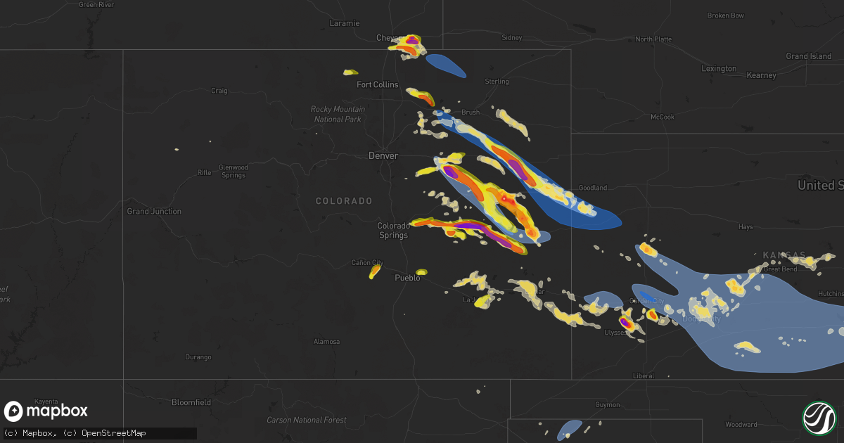
Hail Map on June 8, 2024
Get this storm
June 8 map
$229
one time, instant access
Download today. No call, no setup
Keep the $229
Bought the map and want the full workflow? Apply the entire $229 to a subscription within 7 days. None of it is wasted.
Every map, not just this one
This buys you this map. Subscription and you get every map we run, in the markets you choose from a few cities to whole states to nationwide. Plus real-time alerts the moment a storm fires.
Contact data
Name, contact info, occupancy, even credit band for addresses in the footprint. You go from where it hit to who to call.
Become the source they trust
Unlimited branding weather history reports on demand. You already have the documented answer ready for the property owner, and you are the one who showed up with it.
Property data and RoofTrace estimates
Pull up any address you have got, its value and the exact code rules for that jurisdiction, straight from One Click Code. Then RoofTrace estimates the squares, pitch, and roof value, priced the way you price.
States Impacted by Hail Map on June 8, 2024
Storm reports
Arkansas
| Date | Description |
|---|---|
| 06/08/202412:28 AM CDT | A local report indicates 1.00 inch wind near Leachville |
| 06/07/202411:55 PM CDT | A large tree was knocked near terminal road in piggott. Time approximate based on radar. |
Michigan
| Date | Description |
|---|---|
| 06/08/20245:02 PM CDT | Report from social media of hail up to the size of a quarter in superior... By brimley. Time estimated from radar. |
Colorado
| Date | Description |
|---|---|
| 06/08/20246:54 PM CDT | Kcovona2 reported a 59 mph gust. |
| 06/08/20246:51 PM CDT | Report via ambient weather network. |
| 06/08/20246:45 PM CDT | Public report and photo via social media. Hail size estimated from photo. |
| 06/08/20246:31 PM CDT | Corrects previous hail report from 15 n kit carson. Hail up to 1 inch from spotters live feed. |
| 06/08/20246:27 PM CDT | A local report indicates 59 MPH wind near 4 W Cope |
| 06/08/20246:26 PM CDT | Via live stream. |
| 06/08/20246:15 PM CDT | Picture on x from storm chaser showing snapped power poles near anton. Straight line winds were estimated around 100 mph. |
| 06/08/20246:14 PM CDT | A local report indicates 64 MPH wind near 12 S Otis |
| 06/08/20246:04 PM CDT | Report from mping: trees uprooted or snapped; roof blown off. |
| 06/08/20245:59 PM CDT | A local report indicates 65 MPH wind near 7 SW Elba |
| 06/08/20245:54 PM CDT | Hail fell in addition to the strong winds. Time estimated. |
| 06/08/20245:54 PM CDT | Tree down and blocking highway 34. Spotter reported several downed branches on their property as well. Time estimated. |
| 06/08/20245:54 PM CDT | Storm chaser estimated winds gusted up to 90 mph near platner. |
| 06/08/20245:47 PM CDT | Delayed report. Chaser found hail roughly size of an egg near the intersection of county road 5 and l. |
| 06/08/20245:42 PM CDT | Spotter report of baseball sized hail 3w of hwy 52. |
| 06/08/20245:35 PM CDT | A local report indicates 72 MPH wind near Deer Trail |
| 06/08/20245:34 PM CDT | A local report indicates 65 MPH wind near Woodrow |
| 06/08/20245:29 PM CDT | Also reported larger hail further west towards punkin center... But was unable to provide any additional details at this time. |
| 06/08/20245:27 PM CDT | Report from mping: 1-inch tree limbs broken; shingles blown off. |
| 06/08/20245:26 PM CDT | Public report of hail a bit larger than quarters abt 3.5 ssw of flagler. |
| 06/08/20245:25 PM CDT | Public report and photo via social media. Hail size estimated from photo. |
| 06/08/20245:24 PM CDT | Spotter network report of one power pole snapped and down on east side of highway... Time estimated from radar. |
| 06/08/20245:20 PM CDT | Report from mping: 3-inch tree limbs broken; power poles broken. |
| 06/08/20245:15 PM CDT | Public report and photo via social media. |
| 06/08/20245:00 PM CDT | A local report indicates 2.00 inch wind near 1 ENE Punkin Center |
| 06/08/20244:51 PM CDT | A local report indicates 74 MPH wind near 2 S Fort Morgan |
| 06/08/20244:33 PM CDT | Report via personal weather station. |
| 06/08/20244:33 PM CDT | Mesonet station co039 wiggins bijou creek. |
| 06/08/20244:30 PM CDT | A local report indicates 66 MPH wind near 4 SSW Orchard |
| 06/08/20244:25 PM CDT | Relayed report. Time estimated by radar. Also reported very heavy rain and strong winds... But did not provide an estimate. |
| 06/08/20243:29 PM CDT | A local report indicates 60 MPH wind near 3 SW Hereford |
| 06/08/20243:06 PM CDT | Report from mping: ping pong ball |
| 06/07/20248:38 PM CDT | U40 firstview. |
| 06/07/20248:21 PM CDT | Spotter network report. |
| 06/07/20248:19 PM CDT | Trained spotter reports estimated 100 mph winds ongoing. House is trembling and lawn furniture is moving. Pea sized hail too. |
| 06/07/20248:19 PM CDT | Corrects previous tstm wnd gst report from 12 s peconic after nws survey. Trained spotter reports estimated 100 mph winds ongoing. House is trembling and lawn furniture |
| 06/07/20248:17 PM CDT | Mesonet station co068 040w460 u40-firstview. |
| 06/07/20248:14 PM CDT | Kcocheye8 reports of a gust of 58 mph. |
| 06/07/20248:14 PM CDT | Kcoarapa3 reports 58 mph gust. |
| 06/07/20248:09 PM CDT | Weatherlink station andrews farms. |
| 06/07/20248:07 PM CDT | Trained spotter with anemometer measured an 82 mph gust at wild horse due to outflow. |
| 06/07/20247:59 PM CDT | Mesonet station up695 aroya |
| 06/07/20247:58 PM CDT | Sustained at 47 mph. |
| 06/07/20247:53 PM CDT | Asos station kitr burlington co airport. |
| 06/07/20247:53 PM CDT | Asos station klaa lamar airport. |
| 06/07/20247:48 PM CDT | Asos station kitr burlington co airport. |
| 06/07/20247:45 PM CDT | Weather link station road u. |
| 06/07/20247:43 PM CDT | Asos station kitr burlington co airport. |
| 06/07/20247:35 PM CDT | Reported via kcobethu6. |
| 06/07/20247:29 PM CDT | Mesonet station up711 7.7 nw boyero |
| 06/07/20247:29 PM CDT | Mesonet station up711 7.7 nw boyero . Also |
| 06/07/20247:27 PM CDT | Kcostrat21. |
| 06/07/20247:25 PM CDT | Ambient weather station sevenfarms. |
| 06/07/20247:23 PM CDT | Report from mping: quarter |
| 06/07/20247:13 PM CDT | Wunderground station pws-kcohugo12. |
| 06/07/20247:13 PM CDT | Spotter provided pictures showing several large hail stones approximately two inches in diameter. Photos provided via facebook. |
| 06/07/20247:05 PM CDT | Mesonet station ew0539 hugo. |
| 06/07/20247:02 PM CDT | Wunderground station pws-kcogenoa3. |
| 06/07/20247:00 PM CDT | Public report and photo via social media. Hail size estimated from photo. |
Texas
| Date | Description |
|---|---|
| 06/08/20246:42 PM CDT | A local report indicates 59 MPH wind near 3 SE Dumas |
| 06/08/20246:28 PM CDT | Photos via facebook of downed electric line resulting in additional damage to paneling on a house. Small trees were also blown over. |
| 06/08/20245:13 PM CDT | A local report indicates 64 MPH wind near 4 WNW Stratford |
| 06/07/20247:27 PM CDT | Corrects previous hail report from 9 nnw bovina. |
| 06/07/20247:27 PM CDT | A local report indicates 1.00 inch wind near 9 NNW Bovina |
Missouri
| Date | Description |
|---|---|
| 06/08/20246:58 PM CDT | A local report indicates 1.50 inch wind near Nemo |
| 06/08/20246:56 PM CDT | Hail from quarters to half dollar size. |
| 06/08/20246:56 PM CDT | A local report indicates 1.00 inch wind near 3 S Goodson |
| 06/08/20245:57 AM CDT | Trees down in central and southern springfield. Time estimated via radar. |
| 06/08/20245:57 AM CDT | Large trees... Rocks... And tree debris blocking roadways. Time estimated via radar. |
| 06/08/20245:55 AM CDT | Tree fell down knocking over power lines. Time estimated via radar. |
| 06/08/20245:53 AM CDT | Trees and power lines down in north springfield. Time estimated via radar. |
| 06/08/20245:42 AM CDT | Tree down knocking over power lines. Time estimated via radar. |
| 06/08/20245:33 AM CDT | Multiple large trees down and uprooted in and around ash grove. Time estimated via radar. |
| 06/08/20245:30 AM CDT | Delayed report of a large tree down blocking farm road 5. Time estimated via radar. |
| 06/08/20242:45 AM CDT | Image via social media of golf ball sized hail near rolla. Location and time estimated via radar. |
| 06/08/20242:25 AM CDT | Pictures and video from fire department and citizens near jerome depict widespread wind damage with uprooted and snapped trees and some outbuildings collapsed. |
| 06/08/20241:54 AM CDT | Mping of quarter-sized hail near iconium. Location matched up with radar signatures. Time estimated via radar. |
| 06/07/202411:05 PM CDT | A large tree was reported down on highway cc. |
| 06/07/202410:26 PM CDT | Several large tree limbs and a tree were reported down on highway c. |
| 06/07/20249:56 PM CDT | A local report indicates 1.00 inch wind near Drury |
| 06/07/20248:59 PM CDT | A local report indicates 1.75 inch wind near 1 ESE Cabool |
| 06/07/20248:32 PM CDT | A local report indicates 1.00 inch wind near 1 NW Northview |
| 06/07/20248:32 PM CDT | (sg |
| 06/07/20248:17 PM CDT | A local report indicates 1.00 inch wind near 2 SW Bassville |
| 06/07/20248:15 PM CDT | A local report indicates 1.00 inch wind near 2 SW Bassville |
Tennessee
| Date | Description |
|---|---|
| 06/08/20241:03 AM CDT | A local report indicates 60 MPH wind near Dyersburg |
Kansas
| Date | Description |
|---|---|
| 06/08/20243:24 AM CDT | A local report indicates 62 MPH wind near Chanute |
| 06/08/20243:21 AM CDT | Report from mping: 3-inch tree limbs broken; power poles broken. |
| 06/08/20243:12 AM CDT | Report from mping: trees uprooted or snapped; roof blown off. |
| 06/08/20242:50 AM CDT | Tree limbs down. |
| 06/08/20242:45 AM CDT | Reported by off-duty mcconnell afb meteorologist. |
| 06/08/20242:45 AM CDT | Power lines down at greenwich & douglas. |
| 06/08/20242:39 AM CDT | Several large trees and tree limbs down. |
| 06/08/20242:39 AM CDT | 12 inch diameter limb/branches broken... Picture on twitter. |
| 06/08/20242:38 AM CDT | A local report indicates 66 MPH wind near Wichita Eisenhower Airp |
| 06/08/20242:35 AM CDT | Report from mping: trees uprooted or snapped;. |
| 06/08/20242:30 AM CDT | Large tree limbs down and no power in parts of town. |
| 06/08/20242:25 AM CDT | A local report indicates 67 MPH wind near 6 NNW Viola |
| 06/08/20242:23 AM CDT | A local report indicates 60 MPH wind near Viola |
| 06/08/20242:22 AM CDT | A local report indicates 62 MPH wind near 6 S Clearwater |
| 06/08/20242:03 AM CDT | Report from mping: trees uprooted or snapped; roof blown off. |
| 06/08/20242:02 AM CDT | Rain blowing horizontal. Visibility reduced to about 30 ft. |
| 06/08/20241:20 AM CDT | A local report indicates 65 MPH wind near Kinsley |
| 06/08/20241:20 AM CDT | A local report indicates 60 MPH wind near 2 SE Medicine Lodge |
| 06/08/202412:56 AM CDT | Report from mping: 1-inch tree limbs broken; shingles blown off. |
| 06/08/202412:55 AM CDT | Awos station kptt pratt indust. |
| 06/08/202412:51 AM CDT | Public pictures of a tree uprooted. |
| 06/08/202412:45 AM CDT | Picture on social media of a tree uprooted. |
| 06/08/202412:45 AM CDT | A local report indicates 65 MPH wind near Coats |
| 06/08/202412:38 AM CDT | A local report indicates 60 MPH wind near Pawnee Rock |
| 06/08/202412:24 AM CDT | Report from mping: quarter |
| 06/08/202412:20 AM CDT | Report from mping: 1-inch tree limbs broken. |
| 06/08/202412:10 AM CDT | Sixty to 65 mph wind gust was reported. |
| 06/08/202412:03 AM CDT | Mping report of wind damage trees uprooted/snapped. |
| 06/07/202411:58 PM CDT | Report from mping: 1-inch tree limbs broken; shingles blown off. |
| 06/07/202411:45 PM CDT | Mesonet station dw9907 bloom. |
| 06/07/202411:40 PM CDT | A local report indicates 70 MPH wind near 3 NW Ft. Dodge |
| 06/07/202411:05 PM CDT | A local report indicates 65 MPH wind near Cimarron |
| 06/07/202410:57 PM CDT | Mesonet station ur350 kismws. |
| 06/07/202410:50 PM CDT | Social media pictures of a blown down shed... Damage to metal fencing... And snapping of large tree limbs. |
| 06/07/202410:50 PM CDT | A local report indicates 68 MPH wind near 10 SE Satanta |
| 06/07/202410:40 PM CDT | Corrects previous tstm wnd gst report from 10 nw kalvesta. Corrects previous tstm wnd gst report from 5 sw alamota. |
| 06/07/202410:40 PM CDT | Corrects previous tstm wnd gst report from 5 sw alamota. |
| 06/07/202410:40 PM CDT | A local report indicates 93 MPH wind near 5 SW Alamota |
| 06/07/202410:32 PM CDT | Shingles blown off of roofs. |
| 06/07/202410:32 PM CDT | A local report indicates 72 MPH wind near 4 NW Pierceville |
| 06/07/202410:31 PM CDT | 3 inch diameter branches down. |
| 06/07/202410:22 PM CDT | Report from mping: 1-inch tree limbs broken; shingles blown off. |
| 06/07/202410:18 PM CDT | A local report indicates 80 MPH wind near 3 N Garden City |
| 06/07/202410:15 PM CDT | A local report indicates 2.50 inch wind near 8 NE Hickok |
| 06/07/202410:15 PM CDT | The emergency manager reported 28 high voltage transmission poles blown down. Time was estimated by radar. |
| 06/07/202410:12 PM CDT | Report from mping: 3-inch tree limbs broken; power poles broken. |
| 06/07/20249:57 PM CDT | A local report indicates 3.00 inch wind near 11 S Lakin |
| 06/07/20249:55 PM CDT | A local report indicates 58 MPH wind near 1 E Scott City |
| 06/07/20249:38 PM CDT | A local report indicates 1.75 inch wind near 5 N Scott City |
| 06/07/20249:35 PM CDT | A local report indicates 67 MPH wind near Johnson City |
| 06/07/20249:30 PM CDT | A local report indicates 71 MPH wind near Syracuse |
| 06/07/20248:58 PM CDT | Dispatch reports 65 mph gusts with the storms. |
| 06/07/20248:54 PM CDT | Sixty to 70 mph thunderstorm wind gusts were estimated. |
| 06/07/20248:50 PM CDT | A local report indicates 1.25 inch wind near 12 N Sharon Springs |
| 06/07/20248:10 PM CDT | Public report of 70 mph estimated winds and pea sized hail. |
New Mexico
| Date | Description |
|---|---|
| 06/08/20244:54 PM CDT | Asos station krow roswell air center. |
| 06/08/20244:31 PM CDT | Asos station krow roswell air center. |
| 06/08/20244:30 PM CDT | Corrects previous tstm wnd gst report from 3 w midway. Asos station krow roswell air center. |
Wyoming
| Date | Description |
|---|---|
| 06/08/20242:27 PM CDT | Trained spotter measured 2.0 inch hail east of cheyenne. Exact location was estimated via radar. |
Cities Impacted by Hail Map on June 8, 2024
- Gardiner, ME
- Jefferson, ME
- Alna, ME
- Newcastle, ME
- Cheyenne, WY
- Burns, WY
- Carpenter, WY
- Hillsdale, WY
- Red Feather Lakes, CO
- Bellvue, CO
- Nobleboro, ME
- Livermore, CO
- Bennett, CO
- Strasburg, CO
- Elizabeth, CO
- Kiowa, CO
- Peyton, CO
- Byers, CO
- Deer Trail, CO
- Calhan, CO
- Nunn, CO
- Grover, CO
- Carr, CO
- Arimo, ID
- Lava Hot Springs, ID
- Yoder, CO
- Rush, CO
- Gill, CO
- Downey, ID
- Greeley, CO
- Eaton, CO
- Fort Sumner, NM
- Briggsdale, CO
- Ramah, CO
- Rifle, CO
- Galeton, CO
- Hereford, CO
- White Deer, TX
- New Raymer, CO
- Kersey, CO
- Keenesburg, CO
- Skellytown, TX
- Woodrow, CO
- Genoa, CO
- Roggen, CO
- Pueblo, CO
- Boone, CO
- Stoneham, CO
- Orchard, CO
- Wiggins, CO
- Weldona, CO
- Fort Morgan, CO
- Arriba, CO
- Limon, CO
- Hugo, CO
- Matheson, CO
- Flagler, CO
- Stratford, TX
- Manzanola, CO
- Brush, CO
- Akron, CO
- Dalhart, TX
- Olney Springs, CO
- Ordway, CO
- Mills, WY
- Casper, WY
- Lindon, CO
- Seibert, CO
- Karval, CO
- Sugar City, CO
- Tulelake, CA
- Agate, CO
- Floyd, NM
- Otis, CO
- Vona, CO
- Rocky Ford, CO
- Anton, CO
- Kit Carson, CO
- Elida, NM
- La Junta, CO
- Sunray, TX
- Stinnett, TX
- Portales, NM
- Humansville, MO
- Melrose, NM
- Cheraw, CO
- Haswell, CO
- Cope, CO
- Yuma, CO
- Elbert, CO
- Flemington, MO
- Bolivar, MO
- Joes, CO
- Clovis, NM
- Dunnegan, MO
- Polk, MO
- Las Animas, CO
- Lebanon, MO
- Stoutland, MO
- Wheatland, MO
- Hermitage, MO
- Pittsburg, MO
- Half Way, MO
- Macdoel, CA
- Eads, CO
- Stratton, CO
- Plato, MO
- Bucyrus, MO
- Huggins, MO
- Preston, MO
- Simla, CO
- Hasty, CO
- Hartley, TX
- Buffalo, MO
- Bethune, CO
- Laquey, MO
- Falcon, MO
- McClave, CO
- Morse, TX
- Elkland, MO
- Licking, MO
- Success, MO
- Roby, MO
- Friona, TX
- Richland, MO
- Burlington, CO
- Wiley, CO
- Lamar, CO
- Kirk, CO
- Houston, MO
- Mountain Grove, MO
- Graff, MO
- Greenfield, MO
- Kanorado, KS
- Yukon, MO
- Fair Grove, MO
- Solo, MO
- Cheyenne Wells, CO
- Hartville, MO
- Fordland, MO
- Rogersville, MO
- Dadeville, MO
- Perryton, TX
- Strafford, MO
- Spearman, TX
- Walnut Grove, MO
- Everton, MO
- Springfield, MO
- Norwood, MO
- Marshfield, MO
- Summersville, MO
- Eunice, MO
- Holly, CO
- Wild Horse, CO
- Goodland, KS
- Sharon Springs, KS
- Weskan, KS
- Arapahoe, CO
- Wallace, KS
- Eminence, MO
- Elk Creek, MO
- Steelville, MO
- Potosi, MO
- Princeton, OR
- Granada, CO
- Dorris, CA
- Tribune, KS
- Cabool, MO
- Winona, KS
- Syracuse, KS
- Diamond, OR
- Coolidge, KS
- Scott City, KS
- Leoti, KS
- Cuba, MO
- Saint James, MO
- Niangua, MO
- Willard, MO
- Seymour, MO
- Ash Grove, MO
- Manter, KS
- Vanzant, MO
- Willow Springs, MO
- Ironton, MO
- Oronogo, MO
- Mindenmines, MO
- Liberal, MO
- Kendall, KS
- Birch Tree, MO
- Florence, CO
- Wetmore, CO
- Drury, MO
- Ava, MO
- Jasper, MO
- Winona, MO
- Cherryville, MO
- Lakin, KS
- Lamar, MO
- Bismarck, MO
- Park Hills, MO
- Fredericktown, MO
- Coal Creek, CO
- Ulysses, KS
- Garden City, KS
- Alton, MO
- Johnson, KS
- Bixby, MO
- Bois D Arc, MO
- Healy, KS
- Dora, MO
- Grinnell, KS
- Oakley, KS
- Marienthal, KS
- Fremont, MO
- Fowler, CO
- Mansfield, MO
- Black, MO
- Lesterville, MO
- Pleasant Hope, MO
- Doniphan, MO
- Centerville, MO
- Penrose, CO
- Brighton, MO
- Pierceville, KS
- Ingalls, KS
- Sublette, KS
- Larned, KS
- Amarillo, TX
- Satanta, KS
- Ellington, MO
- Pomona, MO
- West Plains, MO
- Pottersville, MO
- Couch, MO
- Deerfield, KS
- Holcomb, KS
- Cimarron, KS
- Dighton, KS
- Beeler, KS
- Ness City, KS
- Jetmore, KS
- Hanston, KS
- Long Lane, MO
- Vulcan, MO
- Piedmont, MO
- Ensign, KS
- Wright, KS
- Dodge City, KS
- Mammoth Spring, AR
- Hardy, AR
- Burdett, KS
- Fairdealing, MO
- Harviell, MO
- Lincolnville, KS
- Marion, KS
- Tampa, KS
- Ravenden, AR
- Koshkonong, MO
- Republic, MO
- Phillipsburg, MO
- Burns, OR
- Des Arc, MO
- Patterson, MO
- Greenville, MO
- Hillsboro, KS
- Success, AR
- Maynard, AR
- Poplar Bluff, MO
- Neelyville, MO
- Williamsville, MO
- Williford, AR
- Durham, KS
- Strong City, KS
- Ravenden Springs, AR
- Lyons, KS
- Bushton, KS
- Billings, MO
- Clever, MO
- Kinsley, KS
- Albert, KS
- Otis, KS
- Biggers, AR
- Corning, AR
- Spearville, KS
- Ford, KS
- Offerle, KS
- Nixa, MO
- Copeland, KS
- Peach Orchard, AR
- Ellinwood, KS
- Ash Flat, AR
- Evening Shade, AR
- Black Rock, AR
- Imboden, AR
- Wappapello, MO
- Cherokee Village, AR
- Great Bend, KS
- Paragould, AR
- Chase, KS
- Smithville, AR
- Little River, KS
- Hoisington, KS
- Geneseo, KS
- Montezuma, KS
- Grovespring, MO
- Marmaduke, AR
- Garfield, KS
- Rozel, KS
- Poughkeepsie, AR
- Puxico, MO
- Dudley, MO
- Fisk, MO
- Claflin, KS
- Conway, MO
- Galva, KS
- Lafe, AR
- Beech Grove, AR
- Elmdale, KS
- Emporia, KS
- Minneola, KS
- Fowler, KS
- Ashland, KS
- Bucklin, KS
- Greensburg, KS
- Lewis, KS
- Mullinville, KS
- Powhatan, AR
- Squires, MO
- Ozark, MO
- Wasola, MO
- Stockton, MO
- Mount Vernon, MO
- Monette, AR
- Haviland, KS
- Cardwell, MO
- Noble, MO
- Leachville, AR
- Arbyrd, MO
- Cedar Point, KS
- Brookline, MO
- Sheldon, MO
- Bronaugh, MO
- Rush Center, KS
- Windyville, MO
- Thornfield, MO
- Pawnee Rock, KS
- Aurora, MO
- Waynesville, MO
- Gainesville, MO
- Wilmore, KS
- Coldwater, KS
- Milo, MO
- Burns, KS
- Manila, AR
- Cottonwood Falls, KS
- Ridgely, TN
- Caulfield, MO
- Miller, MO
- Brixey, MO
- Pratt, KS
- Kiowa, KS
- Hardtner, KS
- Medicine Lodge, KS
- Protection, KS
- Sun City, KS
- Coats, KS
- Lake City, KS
- Sawyer, KS
- Iuka, KS
- Byers, KS
- St John, KS
- Macksville, KS
- Belpre, KS
- Stafford, KS
- Hudson, KS
- Turon, KS
- Obion, TN
- Hornbeak, TN
- Nevada, MO
- Etowah, AR
- Clarkridge, AR
- Tecumseh, MO
- Lindsborg, KS
- Gypsum, KS
- Marquette, KS
- Canton, KS
- Marionville, MO
- El Dorado Springs, MO
- Bragg City, MO
- Caruthersville, MO
- Hayti, MO
- Trimble, TN
- Kenton, TN
- Newbern, TN
- Dyersburg, TN
- Rutherford, TN
- Finley, TN
- Trenton, TN
- Lenox, TN
- Friendship, TN
- Halls, TN
- Dyer, TN
- Garnett, KS
- Richmond, KS
- Sturkie, AR
- Salem, AR
- Potwin, KS
- El Dorado, KS
- Gamaliel, AR
- Bakersfield, MO
- Gepp, AR
- Henderson, AR
- Broseley, MO
- Isabel, KS
- Cunningham, KS
- Sylvia, KS
- Waldron, KS
- Anthony, KS
- Zenda, KS
- Sharon, KS
- Nashville, KS
- Hazelton, KS
- Spivey, KS
- Attica, KS
- Williamsburg, KS
- Golden City, MO
- Mcpherson, KS
- Viola, AR
- Elizabeth, AR
- Cassoday, KS
- Florence, KS
- Madison, KS
- Matfield Green, KS
- Burdick, KS
- Westphalia, KS
- Waverly, KS
- Collins, MO
- Osceola, MO
- Centerville, KS
- Olpe, KS
- Lockwood, MO
- Hartford, KS
- Dixon, MO
- Crocker, MO
- Mound City, KS
- Roxbury, KS
- Quincy, MO
- Weaubleau, MO
- Jerico Springs, MO
- Gridley, KS
- Bells, TN
- Jackson, TN
- Arcola, MO
- Duke, MO
- Fort Leonard Wood, MO
- Warsaw, MO
- Welda, KS
- Towanda, KS
- Norwich, KS
- Milan, KS
- Wellington, KS
- Kingman, KS
- Conway Springs, KS
- Danville, KS
- Harper, KS
- Arlington, KS
- Murdock, KS
- Milton, KS
- Mayfield, KS
- Belle Plaine, KS
- Argonia, KS
- Clearwater, KS
- Cheney, KS
- Freeport, KS
- Viola, KS
- Peck, KS
- Newburg, MO
- Edwards, MO
- Goddard, KS
- Garden Plain, KS
- Jerome, MO
- Sterling, KS
- Virgil, KS
- Hamilton, KS
- Morrisville, MO
- Colony, KS
- Iola, KS
- Plevna, KS
- Valley Center, KS
- Maize, KS
- Abbyville, KS
- Andale, KS
- Colwich, KS
- Hutchinson, KS
- Wichita, KS
- Partridge, KS
- Haven, KS
- Mount Hope, KS
- Haysville, KS
- Pretty Prairie, KS
- Lavinia, TN
- Alamo, TN
- Huntingdon, TN
- Humboldt, TN
- Trezevant, TN
- Cedar Grove, TN
- Bradford, TN
- Milan, TN
- Atwood, TN
- Westport, TN
- McKenzie, TN
- Buena Vista, TN
- Greenfield, TN
- Medina, TN
- Yuma, TN
- Gadsden, TN
- Moran, KS
- Rolla, MO
- Tunas, MO
- La Harpe, KS
- Kincaid, KS
- Toronto, KS
- Sugar Tree, TN
- Prescott, KS
- Pleasanton, KS
- Cross Timbers, MO
- Mulvane, KS
- Derby, KS
- Fredonia, KS
- Yates Center, KS
- Buffalo, KS
- Mcconnell Afb, KS
- Linden, TN
- Fall River, KS
- Urbana, MO
- Macks Creek, MO
- Fort Scott, KS
- Hume, MO
- Benton, KS
- Greenwich, KS
- Whitewater, KS
- Sedgwick, KS
- Elbing, KS
- Kechi, KS
- Newton, KS
- Bentley, KS
- Burrton, KS
- Udall, KS
- Burden, KS
- Winfield, KS
- Rock, KS
- Augusta, KS
- Andover, KS
- Douglass, KS
- Atlanta, KS
- Leon, KS
- Rose Hill, KS
- Benedict, KS
- Bronson, KS
- Uniontown, KS
- Redfield, KS
- Clifton, TN
- Bath Springs, TN
- Aldrich, MO
- Chanute, KS
- Humboldt, KS
- Panhandle, TX
- Parsons, TN
- Elsmore, KS
- Savonburg, KS
- Waynesboro, TN
- Erie, KS
- Macomb, MO
- Eureka, KS
- Latham, KS
- Rosalia, KS
- Piedmont, KS
- Beaumont, KS
- Severy, KS
- Cambridge, KS
- Grenola, KS
- Howard, KS
- Galesburg, KS
- Hepler, KS
- Walnut, KS
- Stark, KS
- Girard, KS
- Saint Paul, KS
- Thayer, MO
- Farlington, KS
- Tiptonville, TN
- Peru, KS
- Pawhuska, OK
- South Greenfield, MO
- Tipton, MO
- Bunceton, MO
- Myrtle, MO
- Pocahontas, AR
- Gatewood, MO
- Delaplaine, AR
- Bruner, MO
- Meade, KS
- Plains, KS
- Kismet, KS
- Liberal, KS
- Moscow, KS
- Hugoton, KS
- Englewood, KS