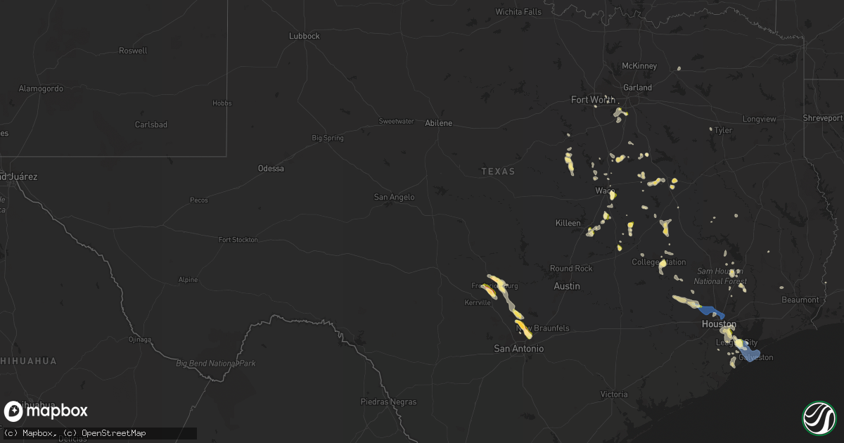
Hail Map in Texas on June 8, 2023
Get this storm
June 8 map
$229
one time, instant access
Download today. No call, no setup
Keep the $229
Bought the map and want the full workflow? Apply the entire $229 to a subscription within 7 days. None of it is wasted.
Every map, not just this one
This buys you this map. Subscription and you get every map we run, in the markets you choose from a few cities to whole states to nationwide. Plus real-time alerts the moment a storm fires.
Contact data
Name, contact info, occupancy, even credit band for addresses in the footprint. You go from where it hit to who to call.
Become the source they trust
Unlimited branding weather history reports on demand. You already have the documented answer ready for the property owner, and you are the one who showed up with it.
Property data and RoofTrace estimates
Pull up any address you have got, its value and the exact code rules for that jurisdiction, straight from One Click Code. Then RoofTrace estimates the squares, pitch, and roof value, priced the way you price.
Storm reports in Texas
Texas
| Date | Description |
|---|---|
| 06/08/20236:45 PM CDT | 1 inch hail reported at fm270 and fm518. |
| 06/08/20236:42 PM CDT | 1 inch hail reported along 40th east street. |
| 06/08/20236:40 PM CDT | Trees down near windsong elementary. |
| 06/08/20236:13 PM CDT | Trained spotter reports quarter sized hail 1 miles s of duncanville at 6:13 pm. |
| 06/08/20236:01 PM CDT | Twitter user shared video of a downed tree along allen parkway. |
| 06/08/20235:46 PM CDT | Social media video of large tree uprooted and fallen over near the intersection of interstate 45 and the north loop near fulton street. Time is estimated based on radar |
| 06/08/20235:43 PM CDT | Trained spotter reported a large tree down in jaycreek drive... Nearly 4 to 6 inches in diameter. |
| 06/08/20235:42 PM CDT | Broadcast media reported a fallen tree on a home. |
| 06/08/20235:39 PM CDT | Twitter user reported trees snapped and blocking lanes along 249 and lakewood crossing dr. |
| 06/08/20235:31 PM CDT | Mping report of quarter sized hail just northeast of cypress. |
| 06/08/20235:21 PM CDT | Social media pictures of downed power lines... Trees... And fences near the intersection of us 290 and barker cypress road. Time is estimated based on radar. |
| 06/08/20234:08 PM CDT | Twitter user reported fallen tree limbs in tarkington. |
| 06/08/20233:50 PM CDT | Report of quarters to ping-pong sized hail near loop 363 and 31st... As well as south and east of that area. Estimated time given in report. |
| 06/08/20233:40 PM CDT | Trained storm spotter reported 1 inch hail near parkland dr. |
| 06/08/20232:35 PM CDT | Hail up to half dollar sized in selma per photos on social media. Location marker is approximate. |
| 06/08/20232:32 PM CDT | Picture of estimated half dollar size hail at toepperwein and nagadoches. |
| 06/08/20232:30 PM CDT | Nws employee reports quarter size hail in universal city. Time estimated from radar. |
| 06/08/20232:24 PM CDT | Pictures of estimated ping pong ball size hail near tpc parkway and the golf course via social media. |
| 06/08/20232:21 PM CDT | Estimated quarter size hail at rolling meadows elementary school. |
| 06/08/20232:02 PM CDT | Golf ball sized hail at 281 and 1863 per nws employee. |
| 06/08/20231:56 PM CDT | Frequent dime size hail increased to quarter size in the past couple of minutes in bulverde. |
| 06/08/20237:05 AM CDT | Nws employee reported sign damage at dunkin donuts and popeyes on boca chica blvd. Time estimated by radar. |
| 06/07/20237:20 PM CDT | Kgls asos measured 61 mph wind gust. |
| 06/07/20237:00 PM CDT | Brigantine cay mesonet site measured 67 mph wind gust. |
All States Impacted by Hail Map on June 8, 2023
Cities Impacted by Hail Map on June 8, 2023
- Rhodesdale, MD
- Vienna, MD
- East New Market, MD
- Petersburg, VA
- Fort Lee, VA
- Prince George, VA
- Disputanta, VA
- Fredericksburg, TX
- Harper, TX
- Bremond, TX
- Calvert, TX
- Waco, TX
- Comfort, TX
- Frankford, DE
- Selbyville, DE
- Riesel, TX
- Bohannon, VA
- Mathews, VA
- Port Haywood, VA
- Foster, VA
- Susan, VA
- Cambridge, MD
- West Point, VA
- Sharptown, MD
- Mardela Springs, MD
- Laurel, DE
- Colonial Heights, VA
- Chesterfield, VA
- Chester, VA
- Dagsboro, DE
- Doss, TX
- Hopewell, VA
- Boerne, TX
- Kendalia, TX
- Spring Branch, TX
- Bulverde, TX
- San Antonio, TX
- Schertz, TX
- Clinton, AR
- Shirley, AR
- Universal City, TX
- Liberal, MO
- Oronogo, MO
- Atkins, AR
- Dardanelle, AR
- Scotland, AR
- Cleveland, AR
- Hattieville, AR
- Gulfport, MS
- Long Beach, MS
- Lott, TX
- Eddy, TX
- College Station, TX
- Cameron, TX
- Milano, TX
- Little River Academy, TX
- Temple, TX
- Rogers, TX
- Saronville, NE
- Harvard, NE
- Clay Center, NE
- Giltner, NE
- Jarratt, VA
- Emporia, VA
- Lagrange, WY
- Hawk Springs, WY
- Napoleon, ND
- Davenport, NE
- Edgar, NE
- Meridian, TX
- Cypress, TX
- Tomball, TX
- Houston, TX
- Lehr, ND
- Colorado Springs, CO
- Wibaux, MT
- Kenmare, ND
- Pasadena, TX
- South Houston, TX
- Bloomingdale, GA
- Kulm, ND
- Fredonia, ND
- Zeeland, ND
- Saint Anthony, ND
- Sterling, ND
- Glendive, MT
- Rolette, ND
- League City, TX
- Kemah, TX
- Dickinson, TX
- Lovelady, TX
- Washburn, ND
- Pine Bluff, AR
- Calder, ID
- Wallace, ID
- Grand Bay, AL
- Italy, TX
- Sundance, WY
- Cohagen, MT
- Irvington, AL
- Covington, LA
- Coleharbor, ND
- Fairfield, TX
- Oakwood, TX
- Bruce, MS
- Randolph, MS
- Gloucester, VA
- Cleveland, TX
- Coldspring, TX
- South Heart, ND
- Livingston, TX
- Kiln, MS
- Cataldo, ID
- Coeur D Alene, ID
- Kosse, TX
- Pass Christian, MS
- Two Dot, MT
- Troy, TX
- Hempstead, TX
- Fairfield Bay, AR
- Sherwood, ND
- Biloxi, MS
- Ruso, ND
- Manville, WY
- West, TX
- Belleville, KS
- Scandia, KS
- Coolidge, TX
- Mexia, TX
- Belfield, ND
- Groesbeck, TX
- Max, ND
- Green Forest, AR
- Alpena, AR
- Teague, TX
- Gheens, LA
- Mathews, LA
- Franklin, TX
- Malad City, ID
- Chilton, TX
- Benedict, ND
- New Caney, TX
- Groveton, TX
- Mertens, TX
- Malone, TX
- Bynum, TX
- Saint Joe, AR
- Harrison, ID
- Pearl River, LA
- Lacombe, LA
- Rison, AR
- Folsom, LA
- Sheridan, WY
- Bottineau, ND
- Mindenmines, MO
- Underwood, ND
- Turtle Lake, ND
- Buffalo, TX
- Richardton, ND
- Beulah, ND
- Shepherd, TX
- Magnolia, MS
- Osyka, MS
- Blue Hill, NE
- Tolley, ND
- Uniontown, KS
- Frost, TX
- Corsicana, TX
- Doniphan, NE
- China Spring, TX
- Ryder, ND
- Douglas, ND
- Garrison, ND
- Holland, TX
- Saucier, MS
- Guide Rock, NE
- Purdon, TX
- Belgrade, MT
- Bergheim, TX
- Stonewall, TX
- Oak, NE
- Harrison, AR
- Kentwood, LA
- Belton, TX
- Dayton, TX
- Hardy, NE
- Crockett, TX
- Reagan, TX
- Lockport, LA
- Centerville, TX
- Abita Springs, LA
- Mandeville, LA
- Grand Island, NE
- Normangee, TX
- Arkadelphia, AR
- Navasota, TX
- Mohall, ND
- Marble Falls, AR
- Jasper, AR
- Pensacola, FL
- Trumbull, NE
- Alda, NE
- Roseglen, ND
- North Zulch, TX
- Marquez, TX
- Kountze, TX
- Ocean City, MD
- Fenwick Island, DE
- Gonzales, LA
- Hillsboro, TX
- Miami, FL
- Hialeah, FL
- La Place, LA
- Cardinal, VA
- Ponchatoula, LA
- Red Cloud, NE
- Theodore, AL
- Mobile, AL
- New Orleans, LA
- Westwego, LA
- Perkinston, MS
- Bryan, TX
- Caldwell, TX
- Fort Pierce, FL
- Aquilla, TX
- Clifton, TX
- Prairie View, TX
- Dutton, VA
- Hallandale, FL
- Hollywood, FL
- Splendora, TX
- Bay Saint Louis, MS
- Raceland, LA
- Iola, TX
- Cut Off, LA
- Larose, LA
- Pointblank, TX
- Vancleave, MS
- Ocean Springs, MS
- Marrero, LA
- Whitney, TX
- Miami Beach, FL
- North Miami Beach, FL
- Opa Locka, FL
- Bacliff, TX
- Duncanville, TX
- Cedar Hill, TX
- Desoto, TX
- Lancaster, TX
- Savannah, GA
- Pooler, GA
- Rugby, ND
- La Marque, TX
- Texas City, TX
- Hitchcock, TX
- Galveston, TX
- Port Bolivar, TX
- Bantry, ND
- Towner, ND
- Granville, ND
- Karlsruhe, ND
- New Iberia, LA
- Saint Martinville, LA
- New Town, ND
- Englewood, CO
- Littleton, CO
- Denver, CO
- Aurora, CO
- Lone Tree, CO
- Watkins, CO
- Devils Lake, ND
- Pitkin, LA
- Stanley, ND
- Dunseith, ND
- Ross, ND
- Terry, MT
- Brockway, MT
- Harvey, ND
- Alta Vista, KS
- Ellabell, GA
- Starks, LA
- Fort Worth, TX
- Downey, ID
- Donnybrook, ND
- Arnegard, ND
- Circle, MT
- Lambert, MT
- Midlothian, TX
- Bismarck, ND
- Cartwright, ND
- Fairview, MT
- Wishek, ND
- Waller, TX
- Elm Mott, TX
- Alliance, NE
- Fallon, MT
- Otter, MT
- Redfield, KS
- Fort Scott, KS
- Denham Springs, LA
- Walker, LA
- Lavina, MT
- Magnolia, TX
- Menoken, ND
- Palermo, ND
- Rainbow, TX
- Cleburne, TX
- Winnett, MT
- Arlington, TX
- Pettibone, ND
- Volborg, MT
- Webster, TX
- Friendswood, TX
- Warren, AR
- Pride, LA
- Greenwell Springs, LA
- Upham, ND
- Eureka, SD
- Whitney, NE
- Oberlin, LA
- Newton, MS
- Buffalo, WY
- Almyra, AR
- De Witt, AR
- Yoder, WY
- Busby, MT
- Custer, MT
- Freeport, TX
- Liverpool, TX
- Santa Fe, TX
- Bighorn, MT
- Deering, ND
- Walnut Springs, TX
- Morgan, TX
- White Castle, LA
- Ashley, ND
- Red Oak, TX
- Newburg, ND
- Maxbass, ND
- Alvin, TX
- Pearland, TX
- Waxahachie, TX
- Crow Agency, MT
- Hockley, TX
- Basile, LA
- Eunice, LA
- Mamou, LA
- Hurdsfield, ND
- Port Allen, LA
- Campbell, TX
- Greenville, TX
- Bowdle, SD
- Roscoe, SD
- Alvarado, TX
- Saint Rose, LA
- Des Allemands, LA
- Prescott, AR
- Grosse Tete, LA
- Rosharon, TX
- Hysham, MT
- Sanders, MT
- Robinson, ND
- Mandan, ND
- Baldwin, ND
- Flasher, ND
- Solen, ND
- Rayne, LA
- Pierre Part, LA
- Napoleonville, LA
- Scottsbluff, NE
- Iredell, TX
- Dallas, TX
- Chandler, TX
- Harrisburg, NE
- Stuttgart, AR
- Garryowen, MT
- Norco, LA
- Hahnville, LA
- Deer Park, TX
- Grand Prairie, TX
- Selby, SD
- Gurdon, AR
- Springfield, LA
- Decker, MT
- Ben Wheeler, TX
- Bailey, CO
- Idaho Springs, CO
- Watford City, ND
- Hardin, MT
- Clearmont, WY
- Hays, MT
- Harlem, MT
- Savage, MT
- Forsyth, MT
- Commerce City, CO
- Banner, WY
- Hosmer, SD
- Mountain View, AR
- Fox, AR
- Theriot, LA
- Jasper, FL
- Wessington, SD
- Saint Lawrence, SD
- Miller, SD
- Crofton, NE
- Bloomfield, NE
- Hartington, NE
- Faulkton, SD
- Seneca, SD
- Mound City, SD
- Chamberlain, SD
- Letcher, SD
- Oacoma, SD
- Strasburg, ND
- Wakpala, SD
- Java, SD
- Tolstoy, SD
- Hoven, SD
- Hitchcock, SD
- Orient, SD
- Mitchell, SD


