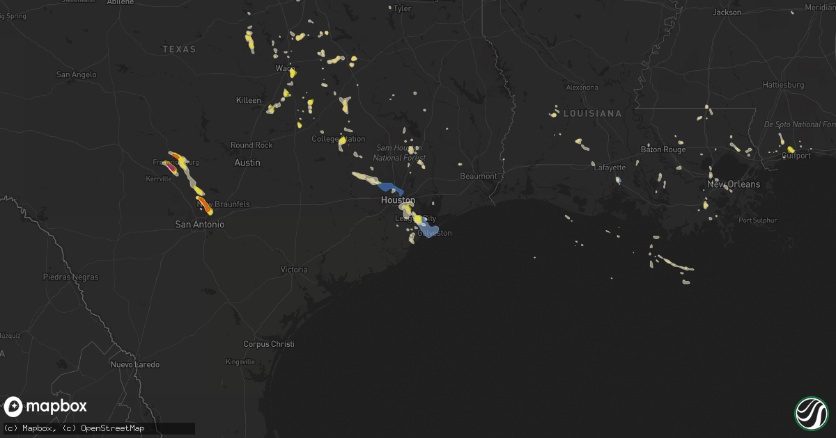
Hail Map on June 8, 2023
Get this storm
June 8 map
$229
one time, instant access
Download today. No call, no setup
Keep the $229
Bought the map and want the full workflow? Apply the entire $229 to a subscription within 7 days. None of it is wasted.
Every map, not just this one
This buys you this map. Subscription and you get every map we run, in the markets you choose from a few cities to whole states to nationwide. Plus real-time alerts the moment a storm fires.
Contact data
Name, contact info, occupancy, even credit band for addresses in the footprint. You go from where it hit to who to call.
Become the source they trust
Unlimited branding weather history reports on demand. You already have the documented answer ready for the property owner, and you are the one who showed up with it.
Property data and RoofTrace estimates
Pull up any address you have got, its value and the exact code rules for that jurisdiction, straight from One Click Code. Then RoofTrace estimates the squares, pitch, and roof value, priced the way you price.
States Impacted by Hail Map on June 8, 2023
Storm reports
North Dakota
| Date | Description |
|---|---|
| 06/08/20236:47 PM CDT | Hail from 1847 to 1853l. |
| 06/08/20236:20 PM CDT | Wind gusts 20 to 30 mph. |
| 06/08/20235:53 PM CDT | Delayed report. Estimated quarter sized hail. Also reported estimated 2 inches of rain. |
| 06/08/20235:47 PM CDT | Heavy rain. Wind gusts 40 to 50 mph. |
| 06/08/20231:47 PM CDT | Mesonet station 323369 4 nnw emmet |
| 06/07/20238:41 PM CDT | Wind gusts 40 to 50 mph. |
Mississippi
| Date | Description |
|---|---|
| 06/08/20232:58 PM CDT | Video of hail at least half dollar in size relayed via social media. |
Nebraska
| Date | Description |
|---|---|
| 06/08/20235:25 PM CDT | Member of the public also called reporting several agricultural pivots blown over. |
| 06/08/20235:19 PM CDT | Meso wl-davenport 0.96sse. |
| 06/08/20233:51 PM CDT | Mesonet/home weather station. |
Virginia
| Date | Description |
|---|---|
| 06/08/20231:13 PM CDT | Hail of at least quarter size from social media video. Video also shows hail covering the ground. Time estimated from radar. |
| 06/08/20231:12 PM CDT | Report of penny to quarter size hail. Time estimated from radar. |
| 06/08/202312:00 PM CDT | A local report indicates 1.00 inch wind near 1 N Cowie Corner |
| 06/08/202311:17 AM CDT | Quarter to half dollar sized hail. Over two inches in depth on the ground. |
| 06/08/202311:15 AM CDT | A local report indicates 1.00 inch wind near 2 SSE Fort Lee |
| 06/08/202310:47 AM CDT | Quarter sized hail and large tree branches down near matoaca elementary school. |
Delaware
| Date | Description |
|---|---|
| 06/08/202312:55 PM CDT | Report of video showing quarter sized hail in bayard... De covering the ground. |
Colorado
| Date | Description |
|---|---|
| 06/08/20235:55 PM CDT | Nickle to quarter sized hail. |
| 06/07/202310:01 PM CDT | Mesonet station co221 aurora i-70/airport blvd. |
Idaho
| Date | Description |
|---|---|
| 06/08/20236:53 PM CDT | Power outages as of 453pm of 1700 customers. |
| 06/08/20236:42 PM CDT | Hwy 97 closed due to multiple trees down. Photo report from social media. |
| 06/08/20236:25 PM CDT | Damaged and dislodged dock and boat from strong wind gusts. Time estimated from radar. |
| 06/08/20236:03 PM CDT | Social media reports of several trees and power lines down in the post falls area. Time estimated from radar. |
| 06/08/20235:59 PM CDT | Power lines down near indian mountain road. Time estimated from radar. |
| 06/08/20235:55 PM CDT | Report from mping: 1-inch tree limbs broken; shingles blown off. |
| 06/08/20235:54 PM CDT | Downed tree limbs and wires near hamaker road. Time estimated from radar. |
| 06/08/20235:53 PM CDT | Corrects previous tstm wnd dmg report from 7 s fernan lake village. Power outages as of 453pm of 1700 customers. |
| 06/08/20235:53 PM CDT | Downed tree has torn avista utility gas line out of the ground near lake cda. Report from social media. |
| 06/08/20235:50 PM CDT | Several reports of tree limbs and power lines down near rathdrum. Time estimated from radar. |
| 06/08/20235:45 PM CDT | Several docks and boats were damaged in the gozzer ranch/arrow point area on lake coeur d alene from thunderstorm wind gusts. Time estimated from radar. |
| 06/08/20235:45 PM CDT | Downed tree limbs and wires near stevens point. Time estimated from radar. |
| 06/08/20235:45 PM CDT | Downed power lines near donavons point. Time estimated from radar. |
| 06/08/20235:42 PM CDT | Corrects previous tstm wnd dmg report from 4 ssw fernan lake village. Hwy 97 closed due to multiple trees down. Photo report from social media. |
| 06/08/20235:41 PM CDT | Downed power lines on eddyville road. Widespread power outages in the area. Time estimated from radar. |
| 06/08/20235:36 PM CDT | Downed power lines near diamond road. Time estimated from radar. |
| 06/08/20235:36 PM CDT | Several reports of power lines and tree limbs down near lane and medimont. Time estimated from radar. |
| 06/08/20235:28 PM CDT | Downed tree through a newly constructed home near farragut state park. Damage to outbuildings reported as well. Severe dock damage reported on scenic bay |
| 06/08/20235:28 PM CDT | Social media report of downed trees and limbs in farragut state park. Power outages reported nearby. Time estimated from radar. |
| 06/08/20235:22 PM CDT | A local report indicates 1.00 inch wind near 4 NNW Rose Lake |
| 06/08/20235:19 PM CDT | Downed power lines near service creek road. Time estimated from radar. |
| 06/08/20234:55 PM CDT | Corrects previous tstm wnd dmg report from 1 nne wardner. Report from mping: 1-inch tree limbs broken; shingles blown off. |
| 06/07/20237:45 PM CDT | Mesonet station lof inl specific manufacturing. |
| 06/07/20237:44 PM CDT | Large tree hit vehicle while traveling. Photo via local news media. |
South Dakota
| Date | Description |
|---|---|
| 06/08/20231:50 AM CDT | Pea size hail. |
Montana
| Date | Description |
|---|---|
| 06/08/20236:30 PM CDT | Hail up to the size of half dollars lasted for 20 minutes |
| 06/08/20236:05 PM CDT | Hail up to the size of quarters. |
| 06/07/20239:20 PM CDT | Mesonet station mtgys geyser |
Louisiana
| Date | Description |
|---|---|
| 06/07/20237:58 PM CDT | Asos station kara new iberia measured a peak wind gust of 60 kt. |
Washington
| Date | Description |
|---|---|
| 06/08/20236:52 PM CDT | Off duty nws employee reports multiple pine trees 4-8 inch diameter down. |
| 06/08/20236:48 PM CDT | Uprooted tree estimated to be 18 inches in diameter. Time estimated from radar. |
| 06/08/20236:47 PM CDT | Corrects previous tstm wnd dmg report from 1 s dishman. Off duty nws employee reports 6 inch tree down. Time estimated based on radar. |
| 06/08/20236:44 PM CDT | Off-duty nws meteorologist reports trees down or snapped near downriver drive. Time estimated from radar. |
| 06/08/20236:39 PM CDT | Social media report of downed tree limbs near mead. Time estimated from radar. |
| 06/08/20236:39 PM CDT | Social media reports of damage to siding and fencing to a property on the north side of spokane. Time estimated from radar. |
| 06/08/20236:39 PM CDT | Downed tree limbs near maple street and interstate 90. Time estimated from radar. |
| 06/08/20236:35 PM CDT | A few public reports of trees and limbs down in spokane valley. Time estimated from radar. |
| 06/08/20236:32 PM CDT | Wind gust 23 with tree limbs broken and heavy rain. |
| 06/08/20236:31 PM CDT | Blown over trash cans... Trees swaying... Road gutter 50 0.000000ull of running water. |
| 06/08/20236:30 PM CDT | Downed power lines and tree limbs sporadically in portions of northern spokane... With several local power outages reported. Time estimated from radar. |
| 06/08/20236:30 PM CDT | Downed tree limbs and power lines east of chattaroy. Time estimated from radar. |
| 06/08/20236:27 PM CDT | Downed tree limbs near mission avenue and pines road. Social media report. Time estimated from radar. |
| 06/08/20236:21 PM CDT | Report from mping: 1-inch tree limbs broken; shingles blown off. |
| 06/08/20236:17 PM CDT | Several reports of power outages and power lines down near newman lake. Time estimated from radar. |
| 06/08/20236:12 PM CDT | Several reports and photos of downed trees and power lines in newman lake and near otis orchards. Time estimated from radar. |
| 06/07/202310:29 PM CDT | Downed trees and power lines on highway 153 south of twisp. Time estimated from radar. |
| 06/07/202310:25 PM CDT | Two-foot diameter tree downed with minor property damage. Time estimated from radar. Location estimated from social media reports. (ot |
| 06/07/202310:25 PM CDT | Two-foot diameter tree downed with minor property damage. Time estimated from radar. Location estimated from social media reports. |
| 06/07/202310:21 PM CDT | Carport roof blown off and downed tree limbs at a residence in oroville. Time estimated from radar. |
| 06/07/202310:04 PM CDT | Downed wires and power outages in the ellisforde area. Time estimated from radar. |
| 06/07/20239:55 PM CDT | Corrects previous tstm wnd gst report from 1 s okanogan for time based on radar data and surrounding wind damage reports. Gust front caused roof to blow off of airplane |
| 06/07/20239:00 PM CDT | Gust front caused roof to blow off of airplane hangar... Damaged an airplane... Took out power... And started a small power line fire. |
| 06/07/20238:37 PM CDT | Downed trees and wires reported southwest of inchelium. Time estimated from radar. |
| 06/07/20238:30 PM CDT | Time estimated from observation. Large tree down measured 7.5 feet diameter. Highest gust recorded was 41 mph in kettle falls at 1830dst. |
| 06/07/20238:21 PM CDT | Tree down on 842 valley westside rd. |
| 06/07/20238:14 PM CDT | Downed trees and wires near pine bluff road. Time estimated from radar. |
| 06/07/20238:10 PM CDT | Downed trees and wires near scott road. Time estimated from radar. |
| 06/07/20238:02 PM CDT | Tree down on alladdin rd due to high wind gust. |
| 06/07/20238:00 PM CDT | Two large trees down along orin rice road. Storm spotter stevens 43. Time estimated from radar. |
| 06/07/20237:56 PM CDT | Trees and wires down near fruitland. Time estimated from radar. |
| 06/07/20237:52 PM CDT | Downed trees and wires near old dominion road. Time estimated from radar. |
| 06/07/20237:45 PM CDT | Outflow gusts from thunderstorms downed power lines south of davenport. Time estimated from radar. |
Texas
| Date | Description |
|---|---|
| 06/08/20236:45 PM CDT | 1 inch hail reported at fm270 and fm518. |
| 06/08/20236:42 PM CDT | 1 inch hail reported along 40th east street. |
| 06/08/20236:40 PM CDT | Trees down near windsong elementary. |
| 06/08/20236:13 PM CDT | Trained spotter reports quarter sized hail 1 miles s of duncanville at 6:13 pm. |
| 06/08/20236:01 PM CDT | Twitter user shared video of a downed tree along allen parkway. |
| 06/08/20235:46 PM CDT | Social media video of large tree uprooted and fallen over near the intersection of interstate 45 and the north loop near fulton street. Time is estimated based on radar |
| 06/08/20235:43 PM CDT | Trained spotter reported a large tree down in jaycreek drive... Nearly 4 to 6 inches in diameter. |
| 06/08/20235:42 PM CDT | Broadcast media reported a fallen tree on a home. |
| 06/08/20235:39 PM CDT | Twitter user reported trees snapped and blocking lanes along 249 and lakewood crossing dr. |
| 06/08/20235:31 PM CDT | Mping report of quarter sized hail just northeast of cypress. |
| 06/08/20235:21 PM CDT | Social media pictures of downed power lines... Trees... And fences near the intersection of us 290 and barker cypress road. Time is estimated based on radar. |
| 06/08/20234:08 PM CDT | Twitter user reported fallen tree limbs in tarkington. |
| 06/08/20233:50 PM CDT | Report of quarters to ping-pong sized hail near loop 363 and 31st... As well as south and east of that area. Estimated time given in report. |
| 06/08/20233:40 PM CDT | Trained storm spotter reported 1 inch hail near parkland dr. |
| 06/08/20232:35 PM CDT | Hail up to half dollar sized in selma per photos on social media. Location marker is approximate. |
| 06/08/20232:32 PM CDT | Picture of estimated half dollar size hail at toepperwein and nagadoches. |
| 06/08/20232:30 PM CDT | Nws employee reports quarter size hail in universal city. Time estimated from radar. |
| 06/08/20232:24 PM CDT | Pictures of estimated ping pong ball size hail near tpc parkway and the golf course via social media. |
| 06/08/20232:21 PM CDT | Estimated quarter size hail at rolling meadows elementary school. |
| 06/08/20232:02 PM CDT | Golf ball sized hail at 281 and 1863 per nws employee. |
| 06/08/20231:56 PM CDT | Frequent dime size hail increased to quarter size in the past couple of minutes in bulverde. |
| 06/08/20237:05 AM CDT | Nws employee reported sign damage at dunkin donuts and popeyes on boca chica blvd. Time estimated by radar. |
| 06/07/20237:20 PM CDT | Kgls asos measured 61 mph wind gust. |
| 06/07/20237:00 PM CDT | Brigantine cay mesonet site measured 67 mph wind gust. |
Georgia
| Date | Description |
|---|---|
| 06/08/20236:55 PM CDT | Tree down on a residence on westlake ave. |
| 06/08/20236:55 PM CDT | Highway sign blown down on i-516 at veterans pkwy. |
| 06/08/20236:55 PM CDT | Tree down on a vehicle on oriole dr. |
| 06/08/20236:55 PM CDT | Highway sign blown down on i-516 at veterans pkwy. |
| 06/08/20236:44 PM CDT | Tree down on quacco rd at laurelwood dr. |
| 06/08/20236:42 PM CDT | Broadcast media relayed a video on social media showing quarter size hail in the enclave neighborhood. |
| 06/08/20236:40 PM CDT | 2 trees down along quacco rd... One fell on a house and one on a vehicle. |
| 06/08/20234:31 PM CDT | Tree and powerlines down across s old perry road near hwy 127. |
| 06/07/20237:07 PM CDT | Broadcast media relayed a report of a large tree down across the roadway near strachan and whitefield ave. Time was estimated via radar data. |
| 06/07/20237:07 PM CDT | Tree down at strachan ave and whitefield ave. |
| 06/07/20237:03 PM CDT | A video on social media relayed by media shows quarter size hail in the southern savannah area. |
| 06/07/20237:00 PM CDT | A wind gust of 53 kt was measured at hunter army airfield. |
Cities Impacted by Hail Map on June 8, 2023
- Rhodesdale, MD
- Vienna, MD
- East New Market, MD
- Petersburg, VA
- Fort Lee, VA
- Prince George, VA
- Disputanta, VA
- Fredericksburg, TX
- Harper, TX
- Bremond, TX
- Calvert, TX
- Waco, TX
- Comfort, TX
- Frankford, DE
- Selbyville, DE
- Riesel, TX
- Bohannon, VA
- Mathews, VA
- Port Haywood, VA
- Foster, VA
- Susan, VA
- Cambridge, MD
- West Point, VA
- Sharptown, MD
- Mardela Springs, MD
- Laurel, DE
- Colonial Heights, VA
- Chesterfield, VA
- Chester, VA
- Dagsboro, DE
- Doss, TX
- Hopewell, VA
- Boerne, TX
- Kendalia, TX
- Spring Branch, TX
- Bulverde, TX
- San Antonio, TX
- Schertz, TX
- Clinton, AR
- Shirley, AR
- Universal City, TX
- Liberal, MO
- Oronogo, MO
- Atkins, AR
- Dardanelle, AR
- Scotland, AR
- Cleveland, AR
- Hattieville, AR
- Gulfport, MS
- Long Beach, MS
- Lott, TX
- Eddy, TX
- College Station, TX
- Cameron, TX
- Milano, TX
- Little River Academy, TX
- Temple, TX
- Rogers, TX
- Saronville, NE
- Harvard, NE
- Clay Center, NE
- Giltner, NE
- Jarratt, VA
- Emporia, VA
- Lagrange, WY
- Hawk Springs, WY
- Napoleon, ND
- Davenport, NE
- Edgar, NE
- Meridian, TX
- Cypress, TX
- Tomball, TX
- Houston, TX
- Lehr, ND
- Colorado Springs, CO
- Wibaux, MT
- Kenmare, ND
- Pasadena, TX
- South Houston, TX
- Bloomingdale, GA
- Kulm, ND
- Fredonia, ND
- Zeeland, ND
- Saint Anthony, ND
- Sterling, ND
- Glendive, MT
- Rolette, ND
- League City, TX
- Kemah, TX
- Dickinson, TX
- Lovelady, TX
- Washburn, ND
- Pine Bluff, AR
- Calder, ID
- Wallace, ID
- Grand Bay, AL
- Italy, TX
- Sundance, WY
- Cohagen, MT
- Irvington, AL
- Covington, LA
- Coleharbor, ND
- Fairfield, TX
- Oakwood, TX
- Bruce, MS
- Randolph, MS
- Gloucester, VA
- Cleveland, TX
- Coldspring, TX
- South Heart, ND
- Livingston, TX
- Kiln, MS
- Cataldo, ID
- Coeur D Alene, ID
- Kosse, TX
- Pass Christian, MS
- Two Dot, MT
- Troy, TX
- Hempstead, TX
- Fairfield Bay, AR
- Sherwood, ND
- Biloxi, MS
- Ruso, ND
- Manville, WY
- West, TX
- Belleville, KS
- Scandia, KS
- Coolidge, TX
- Mexia, TX
- Belfield, ND
- Groesbeck, TX
- Max, ND
- Green Forest, AR
- Alpena, AR
- Teague, TX
- Gheens, LA
- Mathews, LA
- Franklin, TX
- Malad City, ID
- Chilton, TX
- Benedict, ND
- New Caney, TX
- Groveton, TX
- Mertens, TX
- Malone, TX
- Bynum, TX
- Saint Joe, AR
- Harrison, ID
- Pearl River, LA
- Lacombe, LA
- Rison, AR
- Folsom, LA
- Sheridan, WY
- Bottineau, ND
- Mindenmines, MO
- Underwood, ND
- Turtle Lake, ND
- Buffalo, TX
- Richardton, ND
- Beulah, ND
- Shepherd, TX
- Magnolia, MS
- Osyka, MS
- Blue Hill, NE
- Tolley, ND
- Uniontown, KS
- Frost, TX
- Corsicana, TX
- Doniphan, NE
- China Spring, TX
- Ryder, ND
- Douglas, ND
- Garrison, ND
- Holland, TX
- Saucier, MS
- Guide Rock, NE
- Purdon, TX
- Belgrade, MT
- Bergheim, TX
- Stonewall, TX
- Oak, NE
- Harrison, AR
- Kentwood, LA
- Belton, TX
- Dayton, TX
- Hardy, NE
- Crockett, TX
- Reagan, TX
- Lockport, LA
- Centerville, TX
- Abita Springs, LA
- Mandeville, LA
- Grand Island, NE
- Normangee, TX
- Arkadelphia, AR
- Navasota, TX
- Mohall, ND
- Marble Falls, AR
- Jasper, AR
- Pensacola, FL
- Trumbull, NE
- Alda, NE
- Roseglen, ND
- North Zulch, TX
- Marquez, TX
- Kountze, TX
- Ocean City, MD
- Fenwick Island, DE
- Gonzales, LA
- Hillsboro, TX
- Miami, FL
- Hialeah, FL
- La Place, LA
- Cardinal, VA
- Ponchatoula, LA
- Red Cloud, NE
- Theodore, AL
- Mobile, AL
- New Orleans, LA
- Westwego, LA
- Perkinston, MS
- Bryan, TX
- Caldwell, TX
- Fort Pierce, FL
- Aquilla, TX
- Clifton, TX
- Prairie View, TX
- Dutton, VA
- Hallandale, FL
- Hollywood, FL
- Splendora, TX
- Bay Saint Louis, MS
- Raceland, LA
- Iola, TX
- Cut Off, LA
- Larose, LA
- Pointblank, TX
- Vancleave, MS
- Ocean Springs, MS
- Marrero, LA
- Whitney, TX
- Miami Beach, FL
- North Miami Beach, FL
- Opa Locka, FL
- Bacliff, TX
- Duncanville, TX
- Cedar Hill, TX
- Desoto, TX
- Lancaster, TX
- Savannah, GA
- Pooler, GA
- Rugby, ND
- La Marque, TX
- Texas City, TX
- Hitchcock, TX
- Galveston, TX
- Port Bolivar, TX
- Bantry, ND
- Towner, ND
- Granville, ND
- Karlsruhe, ND
- New Iberia, LA
- Saint Martinville, LA
- New Town, ND
- Englewood, CO
- Littleton, CO
- Denver, CO
- Aurora, CO
- Lone Tree, CO
- Watkins, CO
- Devils Lake, ND
- Pitkin, LA
- Stanley, ND
- Dunseith, ND
- Ross, ND
- Terry, MT
- Brockway, MT
- Harvey, ND
- Alta Vista, KS
- Ellabell, GA
- Starks, LA
- Fort Worth, TX
- Downey, ID
- Donnybrook, ND
- Arnegard, ND
- Circle, MT
- Lambert, MT
- Midlothian, TX
- Bismarck, ND
- Cartwright, ND
- Fairview, MT
- Wishek, ND
- Waller, TX
- Elm Mott, TX
- Alliance, NE
- Fallon, MT
- Otter, MT
- Redfield, KS
- Fort Scott, KS
- Denham Springs, LA
- Walker, LA
- Lavina, MT
- Magnolia, TX
- Menoken, ND
- Palermo, ND
- Rainbow, TX
- Cleburne, TX
- Winnett, MT
- Arlington, TX
- Pettibone, ND
- Volborg, MT
- Webster, TX
- Friendswood, TX
- Warren, AR
- Pride, LA
- Greenwell Springs, LA
- Upham, ND
- Eureka, SD
- Whitney, NE
- Oberlin, LA
- Newton, MS
- Buffalo, WY
- Almyra, AR
- De Witt, AR
- Yoder, WY
- Busby, MT
- Custer, MT
- Freeport, TX
- Liverpool, TX
- Santa Fe, TX
- Bighorn, MT
- Deering, ND
- Walnut Springs, TX
- Morgan, TX
- White Castle, LA
- Ashley, ND
- Red Oak, TX
- Newburg, ND
- Maxbass, ND
- Alvin, TX
- Pearland, TX
- Waxahachie, TX
- Crow Agency, MT
- Hockley, TX
- Basile, LA
- Eunice, LA
- Mamou, LA
- Hurdsfield, ND
- Port Allen, LA
- Campbell, TX
- Greenville, TX
- Bowdle, SD
- Roscoe, SD
- Alvarado, TX
- Saint Rose, LA
- Des Allemands, LA
- Prescott, AR
- Grosse Tete, LA
- Rosharon, TX
- Hysham, MT
- Sanders, MT
- Robinson, ND
- Mandan, ND
- Baldwin, ND
- Flasher, ND
- Solen, ND
- Rayne, LA
- Pierre Part, LA
- Napoleonville, LA
- Scottsbluff, NE
- Iredell, TX
- Dallas, TX
- Chandler, TX
- Harrisburg, NE
- Stuttgart, AR
- Garryowen, MT
- Norco, LA
- Hahnville, LA
- Deer Park, TX
- Grand Prairie, TX
- Selby, SD
- Gurdon, AR
- Springfield, LA
- Decker, MT
- Ben Wheeler, TX
- Bailey, CO
- Idaho Springs, CO
- Watford City, ND
- Hardin, MT
- Clearmont, WY
- Hays, MT
- Harlem, MT
- Savage, MT
- Forsyth, MT
- Commerce City, CO
- Banner, WY
- Hosmer, SD
- Mountain View, AR
- Fox, AR
- Theriot, LA
- Jasper, FL
- Wessington, SD
- Saint Lawrence, SD
- Miller, SD
- Crofton, NE
- Bloomfield, NE
- Hartington, NE
- Faulkton, SD
- Seneca, SD
- Mound City, SD
- Chamberlain, SD
- Letcher, SD
- Oacoma, SD
- Strasburg, ND
- Wakpala, SD
- Java, SD
- Tolstoy, SD
- Hoven, SD
- Hitchcock, SD
- Orient, SD
- Mitchell, SD