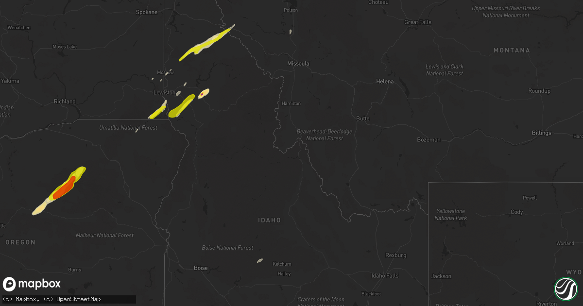
Hail Map in Idaho on June 8, 2016
Get this storm
June 8 map
$229
one time, instant access
Download today. No call, no setup
Keep the $229
Bought the map and want the full workflow? Apply the entire $229 to a subscription within 7 days. None of it is wasted.
Every map, not just this one
This buys you this map. Subscription and you get every map we run, in the markets you choose from a few cities to whole states to nationwide. Plus real-time alerts the moment a storm fires.
Contact data
Name, contact info, occupancy, even credit band for addresses in the footprint. You go from where it hit to who to call.
Become the source they trust
Unlimited branding weather history reports on demand. You already have the documented answer ready for the property owner, and you are the one who showed up with it.
Property data and RoofTrace estimates
Pull up any address you have got, its value and the exact code rules for that jurisdiction, straight from One Click Code. Then RoofTrace estimates the squares, pitch, and roof value, priced the way you price.
Storm reports in Idaho
Idaho
| Date | Description |
|---|---|
| 06/08/20165:48 PM CDT | Quarter sized hail covers the ground. Estimated 45 mph winds. Report from spotters neighbor. |
| 06/08/20165:10 PM CDT | Several 50 foot cottonwood trees blown over onto highway 3 between fernwood and emerald creek. Also dime sized hail. |
| 06/08/20164:50 PM CDT | Wind gust to 25 mph. . |
| 06/08/20164:45 PM CDT | Very large hail near the intersection of us route 12 and idaho hwy 11 in greer around 2:45 pm pdt this afternoon. |
| 06/08/20164:40 PM CDT | Quarter sized hail reported via facebook. |
| 06/08/20164:24 PM CDT | . |
| 06/08/20163:50 PM CDT | Wind gust to 25 mph. . |
| 06/08/20163:45 PM CDT | Very large hail near the intersection of us route 12 and idaho hwy 11 in greer around 2:45 pm pdt this afternoon. |
| 06/08/20163:00 AM CDT | 300ft barn roof collapsed and destroyed at the eastern idaho state fairgrounds |
| 06/08/20163:00 AM CDT | Reports of multiple trees and power lines down causing power outages east of the 700-800e block of basalt. Time estimated from radar. |
| 06/08/20162:59 AM CDT | Trees uprooted and several large branches blown down. Time based on radar. |
All States Impacted by Hail Map on June 8, 2016
Cities Impacted by Hail Map on June 8, 2016
- Haigler, NE
- Lance Creek, WY
- Edgemont, SD
- Peyton, CO
- Long Creek, OR
- Kimberly, OR
- Monument, OR
- Craigmont, ID
- Lewiston, ID
- Winchester, ID
- Limon, CO
- Kilkenny, MN
- Calhan, CO
- Prior Lake, MN
- Shakopee, MN
- Eden Prairie, MN
- Savage, MN
- Anatone, WA
- Clarkston, WA
- Asotin, WA
- Mayer, MN
- Silver Lake, MN
- Winsted, MN
- Delano, MN
- Waverly, MN
- Montrose, MN
- New Germany, MN
- Howard Lake, MN
- Watertown, MN
- Pennock, MN
- Burnsville, MN
- Saint Paul, MN
- Shelby, MT
- Hanley Falls, MN
- Cottonwood, MN
- Armstrong, IA
- Fernwood, ID
- Clarkia, ID
- Wallace, ID
- Saint Maries, ID
- Rushville, NE
- Kalispell, MT
- Chanhassen, MN
- Victoria, MN
- Carver, MN
- Chaska, MN
- Minneapolis, MN
- Cologne, MN
- Waconia, MN
- Jordan, MN
- Colorado Springs, CO
- Le Center, MN
- Genoa, CO
- Austin, MN
- Rose Creek, MN
- Albert Lea, MN
- Hollandale, MN
- Custer, SD
- Moscow, ID
- Coram, MT
- Columbia Falls, MT
- Avery, ID
- Gordon, NE
- Redwood Falls, MN
- Belview, MN
- Kerkhoven, MN
- McDonald, KS
- Saltese, MT
- Harvard, ID
- Le Sueur, MN
- Mitchell, OR
- Pilot Rock, OR
- Lake Lillian, MN
- Roy, NM
- Weippe, ID
- Orofino, ID
- Nezperce, ID
- Corona, SD
- Montgomery, MN
- Eads, CO
- Sheridan Lake, CO
- Greeley, NE
- Raymond, MN
- Murdock, MN
- Fort Sumner, NM
- Bird City, KS
- Hayward, MN
- Glenville, MN
- Lead, SD
- Hungry Horse, MT
- Buffalo, MN
- Mountain Lake, MN
- North Platte, NE
- Brighton, CO
- Fort Lupton, CO
- Santa Rosa, NM
- Yuma, CO
- Wallowa, OR
- Waelder, TX
- Keenesburg, CO
- Wray, CO
- Merriman, NE
- Starbuck, MN
- Benson, MN
- Ortonville, MN
- Sleepy Eye, MN
- Moorcroft, WY
- La Junta, CO
- Bingham Lake, MN
- Willmar, MN
- Faribault, MN
- Larned, KS
- Lenore, ID
- Browning, MT
- Callaway, NE
- Saint Francis, KS
- Lakeville, MN
- Appleton, MN
- Holloway, MN
- Jeffers, MN
- Bard, NM
- San Jon, NM
- Fairfield, ID
- Rosanky, TX
- Echo, MN
- Swea City, IA
- Newcastle, WY
- Hutchinson, MN
- Cokato, MN
- Lester Prairie, MN
- Mound, MN
- Cotulla, TX
- Charlo, MT
- Saint Ignatius, MT
- Brady, NE
- Newkirk, NM
- Culdesac, ID
- Butterfield, MN
- Heppner, OR
- Colton, WA
- Dunnell, MN
- Sherburn, MN
- Big Stone City, SD
- Lapwai, ID
- Farmington, MN
- Encinal, TX
- Springer, NM
- Waterville, MN
- Truman, MN
- Wood Lake, MN
- Clarkfield, MN
- Maple Plain, MN
- Fairmont, MN
- Welcome, MN
- Ord, NE
- Granada, MN
- Young America, MN
- Morgan, MN
- South Haven, MN
- Forest Lakes, AZ
- Hopkins, MN
- Windom, MN
- Annandale, MN
- Clements, MN
- Reubens, ID
- Peck, ID


