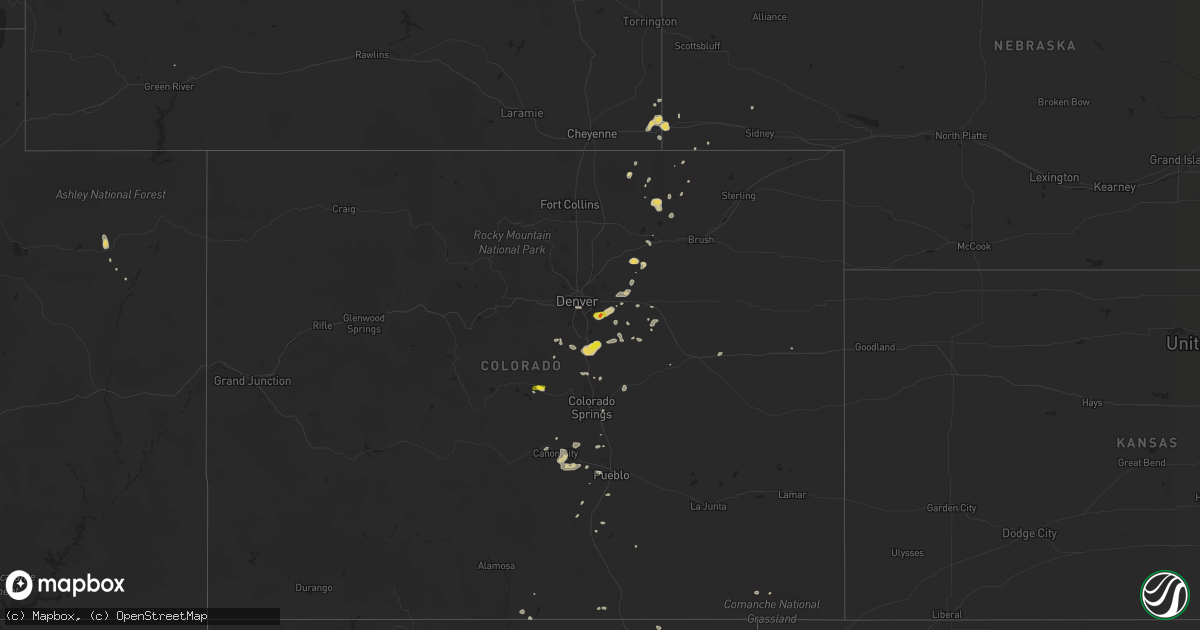
Hail Map on June 8, 2014
Get this storm
June 8 map
$229
one time, instant access
Download today. No call, no setup
Keep the $229
Bought the map and want the full workflow? Apply the entire $229 to a subscription within 7 days. None of it is wasted.
Every map, not just this one
This buys you this map. Subscription and you get every map we run, in the markets you choose from a few cities to whole states to nationwide. Plus real-time alerts the moment a storm fires.
Contact data
Name, contact info, occupancy, even credit band for addresses in the footprint. You go from where it hit to who to call.
Become the source they trust
Unlimited branding weather history reports on demand. You already have the documented answer ready for the property owner, and you are the one who showed up with it.
Property data and RoofTrace estimates
Pull up any address you have got, its value and the exact code rules for that jurisdiction, straight from One Click Code. Then RoofTrace estimates the squares, pitch, and roof value, priced the way you price.
States Impacted by Hail Map on June 8, 2014
Storm reports
Alabama
| Date | Description |
|---|---|
| 06/08/20146:00 PM CDT | Tree down on hickory grove road at county road 81 south. |
| 06/08/20145:42 PM CDT | Tree down on antioch church road. |
| 06/08/20145:42 PM CDT | Tree down on state line road at saint mary church road. |
| 06/08/20145:30 PM CDT | Trees down bethesda road. |
| 06/08/20145:27 PM CDT | At black bear farms |
| 06/08/20145:25 PM CDT | Public reported awning of fast stop gas station blown down |
| 06/08/20145:24 PM CDT | Trees down on county road 28. |
| 06/08/20145:24 PM CDT | Powerlines down on cotton box road. |
| 06/08/20145:24 PM CDT | Trees down on mozell road. |
| 06/08/20145:21 PM CDT | Tree down on power lines on miller merrett road. |
| 06/08/20145:14 PM CDT | Tree down at fortner street and south bay springs road. |
| 06/08/20145:12 PM CDT | Trees down on county road 9. |
| 06/08/20145:00 PM CDT | Public estimated winds between 60 and 70 mph in wicksburg |
| 06/08/20144:53 PM CDT | Tree down on lee boy road and holland road. |
| 06/08/20144:45 PM CDT | At least golf ball hail reported in summerfield. A swath of hail appears likely from summerfield to valley grande and just east of al hwy 22. |
| 06/08/20144:45 PM CDT | Trees reported down in sylacauga with a few trees on some homes. |
| 06/08/20144:42 PM CDT | Tree down on powerline in back yard of residence in level plains. |
| 06/08/20144:31 PM CDT | A local report indicates 1.75 inch wind near VALLEY GRANDE |
| 06/08/20144:10 PM CDT | Trees and power lines down |
| 06/08/20141:54 PM CDT | A local report indicates 1.75 inch wind near ALICEVILLE |
| 06/08/20143:17 AM CDT | Several softwood trees snapped and uprooted. A 12 foot by 12 foot porch uplifted and tossed 30 feet. |
| 06/07/20147:55 PM CDT | Several trees blown down near camp hill at highway 50. |
| 06/07/20147:36 PM CDT | Several trees were blown down in and around valley. |
| 06/07/20147:33 PM CDT | Public reported golf ball size hail 2 north of brewton... Al. |
North Dakota
| Date | Description |
|---|---|
| 06/07/201411:55 PM CDT | A local report indicates 1.00 inch wind near 10 E PERTH |
Florida
| Date | Description |
|---|---|
| 06/08/20146:54 PM CDT | Tree down on post plant road. |
| 06/08/20146:49 PM CDT | Tree down on c and e farm road. |
| 06/08/20146:20 PM CDT | The emergency management had numerous reports of trees down in obrien on both sides of u.s. Highway 129. The time given was based on radar. |
| 06/08/20146:00 PM CDT | Osceola fire rescue reported power lines down at intersection of wiggins rd. And jones road... And also on runmmel road. Time estimated from radar. |
| 06/08/20145:44 PM CDT | Tree down at sr 2 and hwy 71 in malone. |
| 06/08/20145:15 PM CDT | 911 dispatch reports a large tree downed over an apartment complex building. Time of damage based on radar data. |
| 06/08/20145:15 PM CDT | Wcjb-tv relayed a report of a tree falling onto a house near southwest archer road as strong wind gusts from thunderstorms moved through the area. |
| 06/08/20145:05 PM CDT | 911 dispatch reports a tree downed by strong wind gusts along us-441 near paynes prairie as thunderstorms moved through the region. Time of damage based on radar data. |
| 06/08/20145:05 PM CDT | 911 dispatch reports multiple large trees of 15-20 inches in diameter downed by strong wind gusts as thunderstorms moved through the region. Time of damage based on rad |
| 06/08/20145:02 PM CDT | A tree fell on apartment complex on the 4400 block of sw archer road. Some residents had to vacate their apartment due to damage. |
| 06/08/20145:02 PM CDT | A tree fell on apartment complex on the 4100 block of sw archer road. Some residents had to vacate their apartment due to damage. |
| 06/08/20144:45 PM CDT | 911 dispatch reports powerlines downed by strong wind gusts as thunderstorms moved through the region. Time of damage based on radar data. |
| 06/08/20144:45 PM CDT | Trees down |
| 06/08/20144:15 PM CDT | Tree down near the intersection of mahan drive and veterans memorial road |
| 06/08/20144:10 PM CDT | Juniper springs campground personnel reported a few trees down and blocking some camp sites. |
| 06/08/20144:00 PM CDT | Multiple trees and power lines felled in the shadeville road area. |
| 06/08/20143:55 PM CDT | Multiple trees down on baum road. |
| 06/08/20143:50 PM CDT | Tree down on crump and opal roads. |
| 06/08/20143:50 PM CDT | Ocala star banner reported trees and power lines down in salt springs. Time of damage is based on radar data. |
| 06/08/20143:47 PM CDT | Tree down on sage run lane. |
| 06/08/20143:40 PM CDT | Multiple trees down on miccosukee rd. |
| 06/08/20143:36 PM CDT | Multiple trees down on fred george road at mission and old bainbridge roads. |
| 06/08/20143:30 PM CDT | Tree down on grey fox run |
| 06/08/20143:30 PM CDT | Large tree branch blown onto west carolina street |
| 06/08/20143:30 PM CDT | Steeple of st peter primitive baptist church on oak ridge road blown over |
| 06/08/20143:30 PM CDT | Multiple trees down in the bob miller road area |
| 06/08/20143:26 PM CDT | Multiple trees down on fred george road at mission and old bainbridge roads. |
| 06/08/20143:25 PM CDT | Trees and powerlines down on grubbs road and wide road. |
| 06/08/20143:25 PM CDT | Multiple trees down on natural bridge road. |
| 06/08/20143:20 PM CDT | 911 dispatch reports numerous trees and powerlines downed and numerous reports of small hail from palatka to satsuma. |
| 06/08/20143:15 PM CDT | Trees fell on powerlines and a car near theressa. A outdoor shed also blown over. Time of event based on radar imagery. |
| 06/08/20143:15 PM CDT | Putnam county dispatch reports numerous trees and powerlines downed along state road 19 in the vicinity of silver lake drive. Time of damage based on radar data |
| 06/08/20143:10 PM CDT | Powerlines were reported down near brownley and weldon street in starke. |
| 06/08/20142:50 PM CDT | Several trees fell throughout quincy. One tree caught on fire as it struck a power line. |
| 06/08/20141:30 PM CDT | Public report of quarter sized hail via social media. Time of event based on radar data. |
| 06/08/201412:30 PM CDT | 3 trees down near corner of lem turner blvd and hodges street. One tree fell on house. |
| 06/08/201412:15 PM CDT | Wjxt relayed a report of a large tree downed by thunderstorm wind gusts on a home near callahan. Time of damage based on radar data. |
| 06/08/201411:40 AM CDT | Up to quarter size hail reported via social media |
| 06/07/20147:15 PM CDT | A building suffered moderate damage at 10 nw 250th street and a gas station canopy toppled over. |
Colorado
| Date | Description |
|---|---|
| 06/08/20146:45 PM CDT | A local report indicates 66 MPH wind near GRAND JUNCTION |
| 06/08/20146:35 PM CDT | Three trees down at 3rd and grand in downtown grand junction. Diamter estimated 12 inches. Powerlines down from tree fall. |
| 06/08/20146:28 PM CDT | Dead tree limbs down estimated 4 inch in diameter |
| 06/08/20146:22 PM CDT | Tree limbs down estimated 6 inch diameter |
| 06/08/20144:38 PM CDT | A local report indicates 1.00 inch wind near 5 S TRINIDAD |
| 06/08/20144:07 PM CDT | A local report indicates 59 MPH wind near 3 ESE HOEHNE |
| 06/08/20143:30 PM CDT | Multiple cars had windows blown out |
| 06/08/20143:25 PM CDT | A local report indicates 61 MPH wind near 4 NE BLENDE |
| 06/08/20143:01 PM CDT | A local report indicates 58 MPH wind near 2 S ALAMOSA |
| 06/08/20142:45 PM CDT | A local report indicates 1.00 inch wind near PENROSE |
| 06/08/20142:43 PM CDT | A local report indicates 69 MPH wind near MONARCH PASS |
| 06/08/20142:43 PM CDT | Tornado touched down briefly in open field. |
| 06/08/20142:32 PM CDT | A local report indicates a tornado near 12 ESE PROSPECT VALLEY |
| 06/08/20142:24 PM CDT | A local report indicates 1.25 inch wind near CASTLE ROCK |
| 06/08/20142:17 PM CDT | A local report indicates a tornado near 4 SSE ROGGEN |
| 06/08/20142:12 PM CDT | A local report indicates a tornado near 5 ENE PALMER LAKE |
| 06/08/20141:58 PM CDT | *** 1 inj *** damage to construction trailer and golf carts. |
| 06/08/20141:54 PM CDT | No reports of damage. |
| 06/08/20141:43 PM CDT | A local report indicates 1.00 inch wind near AURORA |
| 06/08/20141:40 PM CDT | A local report indicates 1.00 inch wind near CENTENNIAL |
| 06/08/20141:32 PM CDT | Tornado on the ground for several minutes. Some damage near lake george at rv park. 6 rvs were damaged along with damage to cabins and uprooted trees. |
| 06/08/20141:19 PM CDT | A local report indicates 66 MPH wind near MONARCH PASS |
| 06/08/201412:15 PM CDT | Approximate 5 minute touchdown in open country with damage to roof of a structure. No injuries reported. |
Maryland
| Date | Description |
|---|---|
| 06/08/20146:16 PM CDT | Large trees down on old adams rd. |
| 06/08/20146:10 PM CDT | Large tree fell down facing north |
| 06/08/20146:10 PM CDT | Large healthy tree snapped facing east |
| 06/08/20146:01 PM CDT | 7 large trees down including one that fell on a trailor |
| 06/08/20144:49 PM CDT | Trees down near big run road...dry run road and savage river road to the north of big run state park |
Wyoming
| Date | Description |
|---|---|
| 06/08/20142:12 PM CDT | Numerous photos. |
| 06/08/20142:04 PM CDT | Trailer blown over. Trees uprooted. Time estimated by radar. |
| 06/08/20141:58 PM CDT | Nws damage survey and photographic evidence confirms ef0 tornado touched down around 1258 pm mdt along county road 154 northeast of carpenter. The tornado lifted around |
New York
| Date | Description |
|---|---|
| 06/08/20145:48 PM CDT | Report of power lines down at 9444 trenkle rd near cuba lake |
Georgia
| Date | Description |
|---|---|
| 06/08/20146:49 PM CDT | Trees down on state road 262. |
| 06/08/20146:29 PM CDT | Tree down on seminole shores drive. |
| 06/08/20145:16 PM CDT | Multiple trees down on branchville road. |
| 06/08/20143:20 PM CDT | Tree down on pataula heights lane |
| 06/08/20143:13 PM CDT | Several trees were blown down onto state highway 39 in western stewart county. |
| 06/08/20143:10 PM CDT | Tree down on hatcher road |
Virginia
| Date | Description |
|---|---|
| 06/08/20146:57 PM CDT | Trees down. Barn collapsed and shed destroyed on farm on nelson road. |
| 06/08/20146:55 PM CDT | Large tree down on holliday st near the hotel strasburg. |
| 06/08/20146:54 PM CDT | A local report indicates 62 MPH wind near 1 WSW STRASBURG |
| 06/08/20146:27 PM CDT | Trees down at country gardens |
| 06/07/20147:30 PM CDT | Trees down near fellows dr and howellsville rd. |
| 06/07/20147:21 PM CDT | Multiple large trees down near the intersection of fairground rd and milldale rd. |
Pennsylvania
| Date | Description |
|---|---|
| 06/08/20144:15 PM CDT | Trees down on listie road |
| 06/08/20143:18 PM CDT | A local report indicates 1.00 inch wind near 1 NNE SNYDERTOWN |
| 06/08/20143:12 PM CDT | A local report indicates 1.00 inch wind near CONNELLSVILLE |
| 06/08/20143:10 PM CDT | 2 trees down on east crawford ave and wills road |
Arkansas
| Date | Description |
|---|---|
| 06/08/20143:20 PM CDT | Hail reported at faircrest just south of el dorado |
| 06/08/20143:15 PM CDT | A local report indicates 1.00 inch wind near MORO BAY |
| 06/08/20143:12 PM CDT | South jackson street near hwy 167 |
| 06/08/20143:12 PM CDT | Near pigeon hill |
| 06/08/20143:00 PM CDT | Power line down on hwy 82 near marysville |
| 06/08/20142:56 PM CDT | 2 trees down in mt. Holly... Power line down on hwy 82 |
| 06/07/20149:20 PM CDT | Two trees reported down. |
| 06/07/20149:20 PM CDT | A local report indicates 63 MPH wind near 4 NE BENTON |
| 06/07/20149:20 PM CDT | Numerous trees reported down in the city of benton including one on a vehicle. |
Tennessee
| Date | Description |
|---|---|
| 06/08/20146:30 AM CDT | Tree fell on house |
Texas
| Date | Description |
|---|---|
| 06/08/20146:10 AM CDT | Wind damage at 3 or 4 homes and 2 businesses. Fences blown down and minor roof damage. Time is approximate. Location is near the city limits border between rockwall and |
| 06/08/20145:15 AM CDT | Wind gust was measured. Tree damage near boy scout camp. Also a brief period of half inch hail. |
| 06/08/20145:08 AM CDT | Numerous trees and large tree limbs downed by thunderstorm winds. Time is approximate. |
| 06/08/20145:05 AM CDT | Large trees down across southeast side of gainesville and near woodbine. Time is approximate. |
| 06/08/20142:50 AM CDT | A couple tree branches broken |
| 06/08/20142:40 AM CDT | West texas mesonet report |
| 06/08/20142:15 AM CDT | A local report indicates 1.00 inch wind near 10 W FLOYDADA |
| 06/07/201411:59 PM CDT | A local report indicates 1.00 inch wind near 5 ENE HAWLEY |
| 06/07/201410:35 PM CDT | Pecos asos reported 51 knot gust |
| 06/07/201410:31 PM CDT | A local report indicates 1.75 inch wind near 4 W PECOS |
| 06/07/201410:21 PM CDT | At business 20 and 2119 in pecos. Accompanied by strong winds and heavy rain. Slight flooding... But location is a low spot. |
| 06/07/20149:40 PM CDT | A local report indicates 65 MPH wind near 6 NNW AMARILLO |
| 06/07/20149:37 PM CDT | A local report indicates 63 MPH wind near 3 SSE AMARILLO |
| 06/07/20149:35 PM CDT | A local report indicates 66 MPH wind near 9 NNE AMARILLO |
| 06/07/20149:23 PM CDT | A local report indicates 60 MPH wind near BUSHLAND |
| 06/07/20149:20 PM CDT | Traffic barrel blown over at the canadian river bridge. |
| 06/07/20149:12 PM CDT | Several trees blown down. Estimated 60 mph. Very heavy rain also. |
| 06/07/20148:30 PM CDT | Several trees were blown down by thunderstorm winds. Area observations and spotter reports indicate gusts in the 50 mph range. Time estimated by radar. |
| 06/07/20148:19 PM CDT | Richmond road |
Mississippi
| Date | Description |
|---|---|
| 06/08/20146:55 PM CDT | A local report indicates 1.75 inch wind near 3 WSW ELLIOTT |
| 06/08/20146:28 PM CDT | Along highway 35 between holcomb and carrollton |
| 06/08/20146:15 PM CDT | Several trees down west of houston. |
| 06/08/20146:02 PM CDT | Very large hail at least 21/2 inches around the town of pyland. |
| 06/08/20146:00 PM CDT | Reported along bluff lake rd northeast of louisville |
| 06/08/20145:17 PM CDT | Quarter to half dollar size hail along monte vista rd |
| 06/08/20143:30 AM CDT | Trees down on hwy 30. |
| 06/08/20142:45 AM CDT | 60 mph winds along with nickel size hail reported. |
| 06/08/20142:00 AM CDT | Trees down across southern portions of the county including a tree downed on a mobile home trapping a three year old. |
| 06/08/20141:55 AM CDT | Couple of trees down across the county. |
| 06/08/20141:30 AM CDT | Trees down along hwy 488. |
| 06/08/20141:17 AM CDT | A few trees down along hwy 13. |
| 06/08/20141:15 AM CDT | Yard structure twisted and moved a few feet |
| 06/08/20141:10 AM CDT | Tree down across thornhill rd. |
| 06/08/201412:45 AM CDT | Large tree and powerlines down along main street. Couple of other smaller trees down and number of limbs. |
| 06/08/201412:25 AM CDT | A tree was blown down on a house |
| 06/08/201412:25 AM CDT | Trees downed along ms highway 16 |
| 06/07/201411:00 PM CDT | Power lines downed |
| 06/07/20147:05 PM CDT | Oval shaped hail on branscome rd |
| 06/07/20147:05 PM CDT | Tree downed across both lanes of us highway 51 north of duck hill |
| 06/07/20147:02 PM CDT | A local report indicates 2.00 inch wind near SSE ELLIOTT |
| 06/07/20147:01 PM CDT | A local report indicates 1.00 inch wind near ELLIOTT |
Louisiana
| Date | Description |
|---|---|
| 06/08/20146:40 PM CDT | 7 miles east of bernice on la2 |
| 06/08/20146:35 PM CDT | Tree down brought down power lines on scotts hideway road off hwy 2 |
| 06/08/20145:45 PM CDT | A local report indicates 1.00 inch wind near 5 N SHONGALOO |
| 06/08/20142:15 PM CDT | Princeton... La |
| 06/07/20149:05 PM CDT | Tree blown down on hwy 582. |
| 06/07/20147:45 PM CDT | Quarter to golfball sized hail reported along hangout road |
| 06/07/20147:31 PM CDT | A local report indicates 1.75 inch wind near STERLINGTON |
South Carolina
| Date | Description |
|---|---|
| 06/08/20145:20 PM CDT | Tree branch on power lines on brentwood dr. |
| 06/08/20145:11 PM CDT | Tree down on power lines near cooley springs |
| 06/08/20145:05 PM CDT | One inch hail reported right on the nc/sc border sw of green creek. |
| 06/08/20145:02 PM CDT | Tree down on old melvin hill rd. |
| 06/08/20144:37 PM CDT | Public reported several large branches down along with numerous small branches. Dime size hail was also observed along bird island road on lake wateree. Tstm wnd dmg du |
| 06/08/20144:14 PM CDT | Reported trees down on a powerline along garden spot lane near hwy. 97. Tstm wnd dmg duration 2 minutes |
| 06/08/20143:06 PM CDT | Highway patrol reported a tree down at the intersection of state route 200 and edward circle. Tstm wnd dmg duration 2 minutes |
New Mexico
| Date | Description |
|---|---|
| 06/08/20146:53 PM CDT | A local report indicates 1.00 inch wind near LAKE ARTHUR |
| 06/08/20146:50 PM CDT | A local report indicates 1.75 inch wind near 3 NW LAKE ARTHUR |
| 06/08/20146:48 PM CDT | A local report indicates 1.00 inch wind near 7 W LAKE ARTHUR |
| 06/08/20146:43 PM CDT | A local report indicates 1.00 inch wind near LAKE ARTHUR |
| 06/08/20146:39 PM CDT | A local report indicates 1.00 inch wind near RATON |
| 06/08/20146:30 PM CDT | On u.s. Highway 285. |
| 06/08/20146:05 PM CDT | A local report indicates 1.75 inch wind near 10 WSW DEXTER |
| 06/08/20145:55 PM CDT | A local report indicates a tornado near 5 S MAXWELL |
| 06/08/20145:45 PM CDT | A local report indicates a tornado near 5 N SPRINGER |
| 06/08/20145:32 PM CDT | A local report indicates 1.00 inch wind near 3 NNE RATON CREWS AIRPO |
| 06/08/20145:08 PM CDT | A local report indicates a tornado near 11 SW WAGON MOUND |
| 06/08/20144:45 PM CDT | A local report indicates 3.00 inch wind near 7 NNE SHOEMAKER |
| 06/08/20144:45 PM CDT | Small tornado crossed i-25. |
| 06/08/20144:25 PM CDT | Richardson canyon area. 2 homes destroyed... 5 damaged |
| 06/08/20144:25 PM CDT | Richardson canyon area. 2 homes destroyed... 5 damaged |
| 06/08/20142:55 PM CDT | A local report indicates 1.25 inch wind near RAINSVILLE |
| 06/07/201411:58 PM CDT | A local report indicates 1.00 inch wind near TUCUMCARI |
| 06/07/20148:58 PM CDT | A local report indicates 1.00 inch wind near 2 S SAN JON |
| 06/07/20148:55 PM CDT | Tennis ball hail covering the yard |
| 06/07/20148:45 PM CDT | Golf ball size hail and saw 2 funnel clouds |
| 06/07/20148:45 PM CDT | A local report indicates 1.50 inch wind near 8 ENE WHITES CITY |
| 06/07/20148:45 PM CDT | Golf ball size hail and saw 2 funnel clouds |
| 06/07/20148:43 PM CDT | 1 inch hail in mostly 3/4 inch size hail |
| 06/07/20148:40 PM CDT | Hail had busted out kitchen window |
| 06/07/20148:30 PM CDT | A local report indicates 2.50 inch wind near 6 SSW CARLSBAD |
| 06/07/20148:29 PM CDT | A local report indicates 2.50 inch wind near 2 SSW CARLSBAD |
| 06/07/20148:26 PM CDT | A local report indicates 1.25 inch wind near 5 SSW CARLSBAD |
| 06/07/20148:25 PM CDT | A local report indicates 2.50 inch wind near 7 S CARLSBAD |
| 06/07/20148:18 PM CDT | Golfball size hail covering the ground. |
| 06/07/20148:14 PM CDT | A local report indicates 1.00 inch wind near TUCUMCARI |
| 06/07/20148:05 PM CDT | Brief touchdown |
| 06/07/20147:40 PM CDT | A local report indicates 4.00 inch wind near 10 S ARTESIA |
| 06/07/20147:31 PM CDT | Golf ball to hen egg size hail at brevins and 285 in atoka. |
| 06/07/20147:26 PM CDT | A local report indicates 1.25 inch wind near 5 SSW CARLSBAD |
| 06/07/20147:25 PM CDT | Hail measuring 1/2 inch up to 2 1/2 inches. |
| 06/07/20147:15 PM CDT | On south 13th. |
West Virginia
| Date | Description |
|---|---|
| 06/08/20146:23 PM CDT | Trees down near the intersection of river road and pious ridge road |
| 06/08/20146:20 PM CDT | Trees down along sir johns run road |
| 06/08/20145:24 PM CDT | Several trees down in the blue bend area along anthony road about two miles west of the intersection of wv92 and anthony road. |
| 06/08/20145:12 PM CDT | Numerous trees snapped and uprooted. Nws storm survey determined the damage was caused by a wet microburst with estimated winds between 80 and 90 mph. |
| 06/08/20145:12 PM CDT | Many trees down...some trees down on campers |
| 06/08/20145:10 PM CDT | *** 1 inj *** multiple trees down in campers. At least 2 campers completely destroyed. |
| 06/08/20145:10 PM CDT | Roof blown off of house and power lines down in creitz village subdivision |
| 06/08/20144:45 PM CDT | Local emergency management survey indicated a couple hundred trees down in the blue bend area along anthony road about two miles west of the intersection of wv92 and an |
| 06/08/20143:53 PM CDT | A local report indicates 1.00 inch wind near 5 SSE ROWLESBURG |
| 06/08/20143:53 PM CDT | 8 to 10 trees down around the home |
| 06/08/20143:00 PM CDT | Numerous large trees reported downed by thunderstorm winds.0400 pm |
| 06/08/20142:35 PM CDT | A local report indicates 1.00 inch wind near 6 SE LOST CREEK |
| 06/08/20142:35 PM CDT | A local report indicates 1.00 inch wind near 6 ESE LOST CREEK |
| 06/08/20142:30 PM CDT | A local report indicates 1.00 inch wind near 2 SSE STONEWOOD |
| 06/08/20142:30 PM CDT | A local report indicates 1.00 inch wind near LOST CREEK |
| 06/07/20148:06 PM CDT | Trees down 800 blk of featherbed rd |
| 06/07/20147:42 PM CDT | Tree down in 13600 blk apple harvest dr |
| 06/07/20147:41 PM CDT | Ef-1 tornado confirmed by nws storm survey. Peak winds 90 mph. Path length 1.0 mile. Max path width 100 yards. Damage mainly to trees...one residence had porch roof lif |
North Carolina
| Date | Description |
|---|---|
| 06/08/20146:51 PM CDT | At least a few limbs of around 2 inches diameter fell during a strong wind gust produced by the storm. No hail at her location near propst. |
Cities Impacted by Hail Map on June 8, 2014
- Amarillo, TX
- Matador, TX
- Masterson, TX
- Wagon Mound, NM
- El Dorado, AR
- Junction City, AR
- Smackover, AR
- Brownfield, TX
- Grenada, MS
- Roaring Springs, TX
- Paducah, TX
- Kenansville, FL
- San Angelo, TX
- Carlsbad, NM
- Trementina, NM
- Abernathy, TX
- Blakely, GA
- Bluffton, GA
- Clayton, NM
- Madison, FL
- Greenville, FL
- Seagraves, TX
- Garita, NM
- Marathon, TX
- Boise City, OK
- Pecos, TX
- Mentone, TX
- Causey, NM
- Castleberry, AL
- Lenox, AL
- Repton, AL
- Range, AL
- High Springs, FL
- Valley View, TX
- Petersburg, WV
- Maurertown, VA
- Moorefield, WV
- Woodstock, VA
- Edinburg, VA
- Lost City, WV
- Mathias, WV
- Wardensville, WV
- Mora, NM
- Rainsville, NM
- Capitan, NM
- Roswell, NM
- Hagerman, NM
- Lake Arthur, NM
- Dexter, NM
- Alexander City, AL
- Kellyton, AL
- Selma, AL
- Texarkana, AR
- Nash, TX
- Texarkana, TX
- Franktown, CO
- Castle Rock, CO
- Pine Bluffs, WY
- Bard, NM
- Hereford, TX
- San Jon, NM
- Adrian, TX
- Brewton, AL
- Artesia, NM
- Solano, NM
- Evergreen, AL
- Fort Stockton, TX
- Bastrop, LA
- Nocona, TX
- Holly Springs, MS
- Red Banks, MS
- Labelle, FL
- Baker, FL
- Greenwood, MS
- Jersey, AR
- Strong, AR
- Sarepta, LA
- Shongaloo, LA
- Houston, MS
- Calhoun City, MS
- Mantee, MS
- Vardaman, MS
- Houlka, MS
- Woodland, MS
- Eupora, MS
- Walthall, MS
- Inverness, MS
- Fort Davis, TX
- Texico, NM
- Bushnell, NE
- Las Vegas, NM
- Hermitage, AR
- House, NM
- Melrose, NM
- Floyd, NM
- Briggsdale, CO
- Morton, MS
- Pelahatchie, MS
- Brandon, MS
- Flowood, MS
- Ocate, NM
- Starkville, MS
- Elizabeth, CO
- Walters, OK
- Brooksville, MS
- Savannah, GA
- Latrobe, PA
- Forest Home, AL
- Arcadia, FL
- Starke, FL
- Lake Butler, FL
- Conchas Dam, NM
- Quincy, FL
- Jay, FL
- Milton, FL
- Wing, AL
- Camden, AL
- Pine Apple, AL
- Montgomery, AL
- Lafayette, AL
- Colquitt, GA
- Downsville, LA
- Farmerville, LA
- Clayton, AL
- Midway, AL
- Ochopee, FL
- Cuervo, NM
- Newkirk, NM
- Highland Home, AL
- Grady, AL
- Lapine, AL
- Luverne, AL
- Waldo, AR
- Mathews, AL
- Hayneville, AL
- Tyler, AL
- Lowndesboro, AL
- Aurora, CO
- Nesbit, MS
- Lewisville, AR
- Vredenburgh, AL
- Beatrice, AL
- Franklin, AL
- Peterman, AL
- Sterlington, LA
- Marion, LA
- Brent, AL
- Bennett, CO
- Canyon, TX
- Westville, FL
- Hartford, AL
- Samson, AL
- Coffee Springs, AL
- Kinston, AL
- Enterprise, AL
- Black, AL
- Slocomb, AL
- Bonifay, FL
- Geneva, AL
- Chancellor, AL
- Fort Benning, GA
- Aliceville, AL
- Hooks, TX
- Homer, LA
- Bernice, LA
- Dubach, LA
- Farwell, TX
- Carrollton, AL
- Tucumcari, NM
- Merkel, TX
- Daleville, AL
- Newton, AL
- Plain Dealing, LA
- Ashdown, AR
- Georgetown, FL
- Vernon, FL
- Lake City, FL
- Crescent City, FL
- Fort McCoy, FL
- Dunbar, PA
- Vanderbilt, PA
- Lemont Furnace, PA
- Connellsville, PA
- Alpine, TX
- Valmora, NM
- Big Creek, MS
- Duck Hill, MS
- Holcomb, MS
- McCarley, MS
- Carrollton, MS
- Como, MS
- Rogers, NM
- Portales, NM
- Fosters, AL
- Buhl, AL
- Tuscaloosa, AL
- Ralph, AL
- Marion, AL
- Snyder, TX
- McCool, MS
- Weir, MS
- West Milford, WV
- Lost Creek, WV
- Clarksburg, WV
- Bartow, FL
- Sedalia, CO
- Elba, AL
- New Brockton, AL
- Goree, TX
- Seymour, TX
- Milan, GA
- Bellefontaine, MS
- Newberry, FL
- Alachua, FL
- Troy, AL
- Goshen, AL
- Lake George, CO
- Bristol, FL
- Fort Meade, FL
- Altha, FL
- Watkins, CO
- Stewart, MS
- Kilmichael, MS
- Hamilton, GA
- Fortson, GA
- Cataula, GA
- Valley, AL
- Lanett, AL
- Cusseta, AL
- West Point, GA
- Eufaula, AL
- Lamar, MS
- Lakeland, GA
- Pierson, FL
- Branford, FL
- Homerville, GA
- Hernando, MS
- Gunter, TX
- Howe, TX
- Gainesville, TX
- Collinsville, TX
- Ringgold, TX
- Ridgeway, SC
- Camden, SC
- Liberty Hill, SC
- Columbus, MS
- Ethelsville, AL
- Lumpkin, GA
- Leonard, TX
- Hawthorne, FL
- Micanopy, FL
- Gainesville, FL
- Calhan, CO
- Peyton, CO
- Georgetown, GA
- Morris, GA
- Fort Gaines, GA
- Tinnie, NM
- Mer Rouge, LA
- Oak Grove, LA
- Meadow, TX
- Minden, LA
- Haughton, LA
- Princeton, LA
- Laurel Hill, FL
- Crestview, FL
- Punta Gorda, FL
- Odonnell, TX
- Verona, PA
- Florissant, CO
- Gore Springs, MS
- Blue Ridge, TX
- Henrietta, TX
- Bellevue, TX
- Bunnell, FL
- Orange Park, FL
- Jacksonville, FL
- Lake Providence, LA
- Pioneer, LA
- Hawley, TX
- Orchard, CO
- Dothan, AL
- Defuniak Springs, FL
- Fountain, CO
- Happy, TX
- Aledo, TX
- Cresson, TX
- Weatherford, TX
- Winona, MS
- Floydada, TX
- Commerce, TX
- Klondike, TX
- Seminole, TX
- Loop, TX
- Kaufman, TX
- Venus, FL
- Mayo, FL
- Encino, NM
- Havana, FL
- Tallahassee, FL
- Picacho, NM
- Shreveport, LA
- Bossier City, LA
- Sapello, NM
- Watrous, NM
- Tuskegee, AL
- Union Springs, AL
- Hardaway, AL
- Gordon, NE
- Friona, TX
- Loving, NM
- Byhalia, MS
- Goldsboro, TX
- Ovalo, TX
- Lawn, TX
- Duchesne, UT
- Roosevelt, UT
- Pearson, GA
- Duncanville, AL
- Lawtey, FL
- Dalhart, TX
- Fort White, FL
- Macon, MS
- Melissa, TX
- Vega, TX
- Bonham, TX
- Ravenna, TX
- Savoy, TX
- Roggen, CO
- Lancaster, SC
- Sardis, MS
- Vicksburg, MS
- Novice, TX
- Coleman, TX
- Monument, CO
- Mcalister, NM
- Andalusia, AL
- Florala, AL
- Sylacauga, AL
- Childersburg, AL
- Barksdale Afb, LA
- West Blocton, AL
- Centreville, AL
- Strasburg, CO
- Lexington, MS
- Durant, MS
- Midway, FL
- Willacoochee, GA
- Douglas, GA
- Dadeville, AL
- Choudrant, LA
- Eglin Afb, FL
- Raton, NM
- O'Brien, FL
- Larkspur, CO
- Hosford, FL
- Lineville, AL
- Wedowee, AL
- Naylor, GA
- Nashville, GA
- Oviedo, FL
- Rockvale, CO
- Coal Creek, CO
- Florence, CO
- Canon City, CO
- Penrose, CO
- Isola, MS
- Eden, TX
- Cruger, MS
- Tchula, MS
- Youngstown, FL
- Panama City, FL
- Chipley, FL
- Midlothian, TX
- Cedar Hill, TX
- Letohatchee, AL
- Fort Deposit, AL
- Magnolia, AR
- Jack, AL
- Grandfield, OK
- Alberta, AL
- North Carrollton, MS
- Coldwater, MS
- Grady, NM
- Palatka, FL
- Saint Jo, TX
- Muenster, TX
- Clyde, TX
- Wetmore, CO
- Canton, MS
- Newton, GA
- Coffeeville, MS
- Grover, CO
- Keenesburg, CO
- Safford, AL
- Orrville, AL
- Ropesville, TX
- Skellytown, TX
- Panhandle, TX
- Box Springs, GA
- Upatoi, GA
- Smock, PA
- Perryopolis, PA
- Grindstone, PA
- Santa Rosa, NM
- Satsuma, FL
- Orlando, FL
- Fountain, FL
- Crowell, TX
- Lugoff, SC
- Winter Springs, FL
- Fitzpatrick, AL
- West Leisenring, PA
- Mount Braddock, PA
- Waltersburg, PA
- Uniontown, PA
- New Raymer, CO
- Eldorado, TX
- Altheimer, AR
- Webb, AL
- Cowarts, AL
- Denver, CO
- Farmersville, TX
- Kiowa, CO
- Marion Junction, AL
- Catherine, AL
- Frostproof, FL
- Winter Haven, FL
- Felt, OK
- Williston, FL
- Morriston, FL
- Ashford, AL
- Eutaw, AL
- Knoxville, AL
- Sarah, MS
- Daisytown, PA
- Coal Center, PA
- Opp, AL
- Lockney, TX
- Burneyville, OK
- Leon, OK
- Ackerman, MS
- Weldona, CO
- Portland, AR
- Parkdale, AR
- Abbeville, GA
- Genoa, CO
- Talpa, TX
- Immokalee, FL
- Bovina, TX
- Buckner, AR
- Ponce De Leon, FL
- Tahoka, TX
- Minter, AL
- Sardis, AL
- Abilene, TX
- Perry, FL
- Colorado Springs, CO
- Weston, CO
- Dickens, TX
- Palmer Lake, CO
- Deer Trail, CO
- Borger, TX
- Tuscola, TX
- Winters, TX
- Cottondale, AL
- Brookston, TX
- Sumner, TX
- Wildorado, TX
- Salem, WV
- Heath Springs, SC
- Randolph, AL
- Maplesville, AL
- Lawley, AL
- Emerson, AR
- Dimmitt, TX
- Grand Ridge, FL
- Marianna, FL
- Mosquero, NM
- Great Falls, SC
- Blackstock, SC
- Georgiana, AL
- Jane Lew, WV
- Gordo, AL
- San Cristobal, NM
- Stephens, AR
- Conroe, TX
- Midland, GA
- Saint Cloud, FL
- Kissimmee, FL
- Coila, MS
- Debary, FL
- Fleming Island, FL
- Dalton, NE
- Garvin, OK
- De Queen, AR
- Texline, TX
- Crawfordville, FL
- Warren, AR
- East Palatka, FL
- Arroyo Hondo, NM
- El Prado, NM
- Hollywood, FL
- Miami, FL
- Shuqualak, MS
- Bisbee, ND
- Monticello, FL
- Stamps, AR
- Flomot, TX
- Afton, TX
- Jacksons Gap, AL
- Glenwood, AL
- Buffalo Creek, CO
- Conifer, CO
- Goodwater, AL
- Louisville, MS
- Freeport, FL
- Pueblo, CO
- Cottonwood, AL
- Baird, TX
- Clewiston, FL
- Axson, GA
- Columbus, NC
- Campobello, SC
- Landrum, SC
- Middleburg, FL
- Senatobia, MS
- Vaughan, MS
- Bentonia, MS
- England, AR
- Olive Branch, MS
- Minter City, MS
- Philipp, MS
- Schlater, MS
- Wolfforth, TX
- Broken Bow, OK
- Arlington, GA
- Albin, WY
- Olla, LA
- Okeechobee, FL
- New Boston, TX
- Fort Davis, AL
- Benton, MS
- Fitzgerald, GA
- Morgan, GA
- Summerfield, LA
- Rocklake, ND
- Stockton, GA
- Silverton, TX
- Era, TX
- Reddick, FL
- Roanoke, AL
- Wadley, AL
- Mckinney, TX
- Godley, TX
- Shannon, MS
- Pontotoc, MS
- McRae Helena, GA
- Sturgis, MS
- Burkburnett, TX
- Stuttgart, AR
- Lake Mary, FL
- Sanford, FL
- Grayson, LA
- Tioga, TX
- Brantley, AL
- Banks, AR
- Corona, NM
- Bowie, TX
- Clinton, MS
- Jackson, MS
- Tougaloo, MS
- Ridgeland, MS
- Paris, TX
- Eola, TX
- Vancourt, TX
- Maud, TX
- Gainestown, AL
- Jackson, AL
- Waterford, MS
- Byers, CO
- Tulia, TX
- Celeste, TX
- Iuka, MS
- Leary, GA
- Belzoni, MS
- Paint Rock, TX
- Millersview, TX
- Pine Mountain, GA
- Hialeah, FL
- Cotton Valley, LA
- Mathiston, MS
- Whiteface, TX
- Archer, FL
- Fort Lauderdale, FL
- Green Cove Springs, FL
- Mount Clare, WV
- Bridgeport, WV