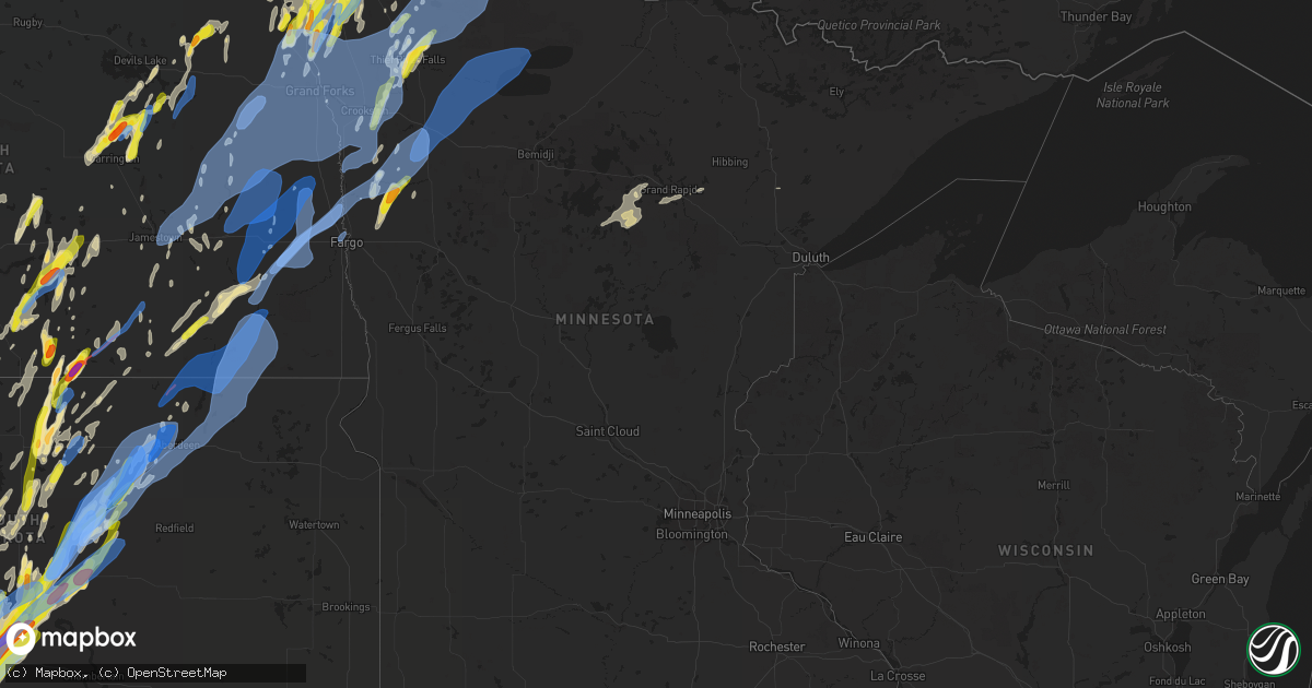
Hail Map in Minnesota on June 7, 2020
Get this storm
June 7 map
$229
one time, instant access
Download today. No call, no setup
Keep the $229
Bought the map and want the full workflow? Apply the entire $229 to a subscription within 7 days. None of it is wasted.
Every map, not just this one
This buys you this map. Subscription and you get every map we run, in the markets you choose from a few cities to whole states to nationwide. Plus real-time alerts the moment a storm fires.
Contact data
Name, contact info, occupancy, even credit band for addresses in the footprint. You go from where it hit to who to call.
Become the source they trust
Unlimited branding weather history reports on demand. You already have the documented answer ready for the property owner, and you are the one who showed up with it.
Property data and RoofTrace estimates
Pull up any address you have got, its value and the exact code rules for that jurisdiction, straight from One Click Code. Then RoofTrace estimates the squares, pitch, and roof value, priced the way you price.
Storm reports in Minnesota
Minnesota
| Date | Description |
|---|---|
| 06/07/20206:55 PM CDT | Hail noted across highway near the border. |
| 06/07/20206:35 PM CDT | A local report indicates 1.00 inch wind near 1 W CARIBOU |
| 06/07/20206:30 PM CDT | Dime to quarter sized hail fell for at least 5 minutes... Through 635 pm cdt. |
| 06/07/20205:52 PM CDT | Report of quarter sized hail via social media. |
| 06/07/20205:52 PM CDT | Report of quarter sized hail via social media. |
| 06/07/20205:35 PM CDT | Report and photo posted via social media. |
| 06/07/20205:25 PM CDT | A local report indicates 1.00 inch wind near 1 NW HALMA |
| 06/07/20205:20 PM CDT | A local report indicates 1.50 inch wind near 5 NNW STEPHEN |
| 06/07/20204:35 PM CDT | A local report indicates 1.00 inch wind near 6 W STRATHCONA |
| 06/07/20204:25 PM CDT | A local report indicates 1.00 inch wind near 7 SE HOLT |
| 06/07/20204:05 PM CDT | A local report indicates 1.75 inch wind near 6 ENE THIEF RIVER FALLS |
| 06/07/20203:50 PM CDT | A local report indicates 1.25 inch wind near 4 ESE THIEF RIVER FALLS |
| 06/07/20203:10 PM CDT | Report and photo posted via social media. Time estimated based on radar. |
| 06/07/20206:55 AM CDT | At 1154 PM CDT, a severe thunderstorm was located near Durbin, or 18 miles southwest of Fargo, moving northeast at 70 mph. HAZARD...60 mph wind gusts and penny size hail. SOURCE...Radar indicated. IMPACT...Expect damage to roofs, siding, and trees. Locations impacted include... Fargo, Moorhead, West Fargo, Dilworth, Horace, Casselton and Glyndon.This includes the following highways... Interstate 29 between mile markers 53 and 99. Interstate 94 in North Dakota between mile markers 320 and 352. Interstate 94 in Minnesota between mile markers 1 and 8. |
| 06/07/20206:15 AM CDT | At 1114 PM CDT, severe thunderstorms were located along a line extending from near Goodridge to near Fosston to 6 miles southwest of Tulaby Lake, moving northeast at 45 mph. HAZARD...60 mph wind gusts. SOURCE...Radar indicated. IMPACT...Expect damage to roofs, siding, and trees. Severe thunderstorms will be near... Weme and Naytahwaush around 1125 PM CDT. Clearbrook and Gonvick around 1130 PM CDT. Long Lost Lake and Bad Medicine Lake around 1135 PM CDT. Leonard around 1140 PM CDT. Zerkel around 1145 PM CDT.Other locations impacted by these severe thunderstorms include CampThunderbird East, Camp Thunderbird West and Many Point Scout Camp. |
| 06/07/20205:45 AM CDT | At 1045 PM CDT, severe thunderstorms were located along a line extending from near Badger to near Gatzke to 7 miles southeast of Espelie, moving northeast at 55 mph. HAZARD...60 mph wind gusts. SOURCE...Radar indicated. IMPACT...Expect damage to roofs, siding, and trees. Severe thunderstorms will be near... Fox and Skime around 1055 PM CDT. Jelle, Carmel and Ross around 1100 PM CDT. Roseau, Thorhult and Fourtown around 1105 PM CDT. Salol around 1110 PM CDT. Norris Camp around 1115 PM CDT. |
| 06/07/20205:14 AM CDT | At 1012 PM CDT, severe thunderstorms were located along a line extending from Wylie to near Fertile to near Ulen, moving east at 40 mph. HAZARD...60 mph wind gusts and penny size hail. Wind gusts of 58 mph were reported in Crookston and wind gusts of 64 mph were reported in Fargo. SOURCE...Radar indicated. IMPACT...Expect damage to roofs, siding, and trees. Severe thunderstorms will be near... Rindal, Ranum and Red Lake Falls around 1020 PM CDT. St. Hilaire around 1025 PM CDT. Winger, Hazel and Bejou around 1030 PM CDT. Plummer around 1035 PM CDT. Ogema and Callaway around 1045 PM CDT.Other locations impacted by these severe thunderstorms include ThiefRiver Falls Airport and Many Point Scout Camp.This includes Interstate 94 in Minnesota between mile markers 11 and24. |
| 06/07/20204:23 AM CDT | At 923 PM CDT, severe thunderstorms were located along a line extending from near Reynolds to Mapleton, moving east at 60 mph. HAZARD...70 mph wind gusts. SOURCE...Radar indicated. IMPACT...Expect considerable tree damage. Damage is likely to mobile homes, roofs, and outbuildings. Severe thunderstorms will be near... West Fargo around 925 PM CDT. Reile's Acres, Harwood and Prairie Rose around 930 PM CDT. Moorhead, Fargo and Oakport around 935 PM CDT. Dilworth and Kragnes around 940 PM CDT. Averill, Glyndon and Harold around 945 PM CDT.Other locations impacted by these severe thunderstorms include ThiefRiver Falls Airport, Casselton Airport, American Crystal Sugar,Moorhead Airport and West Argusville.This includes the following highways... Interstate 29 between mile markers 49 and 124. Interstate 94 in North Dakota between mile markers 331 and 352. Interstate 94 in Minnesota between mile markers 1 and 27. |
| 06/07/20203:57 AM CDT | At 857 PM CDT, a severe thunderstorm was located over Lucca, or 20 miles southeast of Valley City, moving northeast at 60 mph. HAZARD...60 mph wind gusts and quarter size hail. SOURCE...Radar indicated. IMPACT...Hail damage to vehicles is expected. Expect wind damage to roofs, siding, and trees. This severe thunderstorm will be near... Alice around 905 PM CDT. Embden around 910 PM CDT. Buffalo around 915 PM CDT. Wheatland and Absaraka around 920 PM CDT. Casselton around 925 PM CDT.Other locations impacted by this severe thunderstorm includeCasselton Airport and West Argusville.This includes the following highways... Interstate 29 between mile markers 73 and 102. Interstate 94 in North Dakota between mile markers 308 and 338. |
| 06/07/20203:49 AM CDT | At 849 PM CDT, a severe thunderstorm was located 7 miles north of Oriska, or 13 miles northeast of Valley City, moving northeast at 65 mph. HAZARD...70 mph wind gusts and quarter size hail. SOURCE...Radar indicated. IMPACT...Hail damage to vehicles is expected. Expect considerable tree damage. Wind damage is also likely to mobile homes, roofs, and outbuildings. This severe thunderstorm will be near... Page around 900 PM CDT. Colgate around 905 PM CDT. Galesburg around 910 PM CDT. Clifford around 915 PM CDT. Blanchard around 920 PM CDT.Other locations impacted by this severe thunderstorm include AmericanCrystal Sugar.This includes the following highways... Interstate 29 between mile markers 88 and 129. Interstate 94 in North Dakota between mile markers 301 and 314. |
| 06/07/20202:42 AM CDT | At 742 PM CDT, a severe thunderstorm was located over Halma, or 39 miles northeast of Grafton, moving northeast at 45 mph. HAZARD...60 mph wind gusts and half dollar size hail. SOURCE...Radar indicated. IMPACT...Hail damage to vehicles is expected. Expect wind damage to roofs, siding, and trees. Locations impacted include... Karlstad, Lake Bronson, Halma, Lake Bronson State Park and Caribou. |
| 06/07/20201:59 AM CDT | At 659 PM CDT, a severe thunderstorm was located near March, or 25 miles north of Grand Forks, moving northeast at 45 mph. HAZARD...60 mph wind gusts and quarter size hail. SOURCE...Radar indicated. IMPACT...Hail damage to vehicles is expected. Expect wind damage to roofs, siding, and trees. Locations impacted include... Karlstad, Stephen, Argyle, Strandquist, Halma, Florian and March. |
| 06/07/20201:55 AM CDT | At 654 PM CDT, a severe thunderstorm was located 7 miles northeast of Orleans, or 47 miles northeast of Grafton, moving north at 35 mph. HAZARD...60 mph wind gusts and quarter size hail. SOURCE...Radar indicated. IMPACT...Hail damage to vehicles is expected. Expect wind damage to roofs, siding, and trees. This severe thunderstorm will remain over mainly rural areas of north central Kittson County. |
| 06/07/202012:50 AM CDT | Several large tree branches and limbs broken down. |
| 06/07/202012:40 AM CDT | At 539 PM CDT, a severe thunderstorm was located 7 miles southwest of Caribou, or 35 miles west of Roseau, moving north at 30 mph. HAZARD...60 mph wind gusts and half dollar size hail. SOURCE...Radar indicated. IMPACT...Hail damage to vehicles is expected. Expect wind damage to roofs, siding, and trees. This severe thunderstorm will be near... Caribou around 555 PM CDT. |
| 06/07/202012:33 AM CDT | At 532 PM CDT, a severe thunderstorm was located near Ulen, or 25 miles northeast of Fargo, moving northeast at 50 mph. HAZARD...60 mph wind gusts and quarter size hail. SOURCE...Radar indicated. IMPACT...Hail damage to vehicles is expected. Expect wind damage to roofs, siding, and trees. This severe thunderstorm will be near... Ulen around 535 PM CDT. Syre around 540 PM CDT. Twin Valley around 550 PM CDT. Gary and Faith around 555 PM CDT. Waukon around 600 PM CDT. |
| 06/07/202012:30 AM CDT | Large tree branches broken down... Power lines blown down. Report posted via social media. |
| 06/07/202012:29 AM CDT | Peak wind measured at an ndawn station. |
| 06/07/202012:20 AM CDT | Peak wind measured at an ndawn station. |
| 06/07/202012:19 AM CDT | Peak wind measured at an ndawn station. |
| 06/06/202011:53 PM CDT | At 452 PM CDT, a severe thunderstorm was located over Englund, or 31 miles northwest of Thief River Falls, moving north at 45 mph. HAZARD...60 mph wind gusts and half dollar size hail. SOURCE...Radar indicated. IMPACT...Hail damage to vehicles is expected. Expect wind damage to roofs, siding, and trees. Locations impacted include... Karlstad, Lake Bronson, Strandquist, Halma, Florian, Lake Bronson State Park and Englund. |
| 06/06/202011:37 PM CDT | A few poplar trees snapped in a grove. |
| 06/06/202011:35 PM CDT | A few 10 to 12 inch diameter poplar trees were snapped and some large 4-6 inch oak branches were broken down in a grove. |
| 06/06/202011:26 PM CDT | At 426 PM CDT, a severe thunderstorm was located near Middle River, or 19 miles north of Thief River Falls, moving north at 40 mph. HAZARD...60 mph wind gusts and quarter size hail. SOURCE...Radar indicated. IMPACT...Hail damage to vehicles is expected. Expect wind damage to roofs, siding, and trees. Locations impacted include... Greenbush, Badger, Middle River, Strathcona, Leo and Haug. |
| 06/06/202011:23 PM CDT | At 423 PM CDT, a severe thunderstorm was located 9 miles southwest of Gatzke, or 18 miles northeast of Thief River Falls, moving northeast at 40 mph. HAZARD...Golf ball size hail and 60 mph wind gusts. SOURCE...Radar indicated. IMPACT...People and animals outdoors will be injured. Expect hail damage to roofs, siding, windows, and vehicles. Expect wind damage to roofs, siding, and trees. Locations impacted include... Wannaska, Gatzke, Hayes Lake State Park, Pencer, Casperson, Skime and Torfin. |
| 06/06/202011:14 PM CDT | Peak wind measured at a personal weather station. |
| 06/06/202010:50 PM CDT | An 8 to 10 inch diameter tree was snapped. Numerous other large branches broken down. |
| 06/06/202010:45 PM CDT | Large tree branches blown down. Widespread power outages. Report posted via social media. |
| 06/06/202010:40 PM CDT | Large branches broken down in farmyard. Report posted via social media. |
| 06/06/202010:40 PM CDT | At 339 PM CDT, a severe thunderstorm was located over Thief River Falls, moving north at 50 mph. HAZARD...60 mph wind gusts and quarter size hail. SOURCE...Radar indicated. IMPACT...Hail damage to vehicles is expected. Expect wind damage to roofs, siding, and trees. Locations impacted include... Thief River Falls, Newfolden, Middle River, St. Hilaire, Viking, Holt and Strathcona. |
| 06/06/202010:35 PM CDT | A few large 4 to 6 inch diameter tree branches broken down in farmyard. |
| 06/06/202010:30 PM CDT | A few large tree branches blown down near the island lake boat dock. |
| 06/06/202010:22 PM CDT | Roofing torn off a trailer home. Nukerous large tree branches broken down. Report and photo posted via social media. |
| 06/06/202010:20 PM CDT | Large branches broken down... Power lines down... Sections of fencing blown down between north moorhead and dilworth. |
| 06/06/202010:18 PM CDT | Peak wind measured at the thief river falls airport /ktvf/. |
| 06/06/202010:02 PM CDT | At 302 PM CDT, a severe thunderstorm was located near Harold, or 29 miles southwest of Thief River Falls, moving northeast at 55 mph. HAZARD...60 mph wind gusts and half dollar size hail. SOURCE...Radar indicated. IMPACT...Hail damage to vehicles is expected. Expect wind damage to roofs, siding, and trees. This severe thunderstorm will be near... Gentilly around 305 PM CDT. Perault, Marcoux and Huot around 310 PM CDT. Red Lake Falls around 315 PM CDT. Wylie and Terrebonne around 320 PM CDT. St. Hilaire and Plummer around 325 PM CDT.Other locations impacted by this severe thunderstorm include ThiefRiver Falls Airport. |
| 06/06/202010:02 PM CDT | Peak winds measured at the crookston airport /kckn/. |
| 06/06/20209:45 PM CDT | Tree blown over in yard. Report and photo posted via social media. |
| 06/06/20209:03 PM CDT | At 202 AM CDT, severe thunderstorms were located along a line extending from near Rice to near Zimmerman, moving northeast at 25 mph. HAZARD...Half dollar size hail. SOURCE...Radar indicated. IMPACT...Damage to vehicles is expected. Locations impacted include... Cambridge, Elk River, Zimmerman, Princeton, Milaca, Foley, Foreston, Bock, Orrock, Santiago, Spencer Brook and Glendorado.This includes U.S. Highway 169 between mile markers 166 and 200. |
| 06/06/20209:00 PM CDT | At 159 AM CDT, severe thunderstorms were located along a line extending from near Randall to near Rice, moving northeast at 25 mph. HAZARD...Half dollar size hail. SOURCE...Radar indicated. IMPACT...Damage to vehicles is expected. Locations impacted include... Little Falls, Pierz, Royalton, Randall, Lastrup, Camp Ripley, Rice, Morrill, Buckman, Little Rock, Harding and Genola.This includes U.S. Highway 10 in Minnesota between mile markers 132and 157. |
| 06/06/20208:46 PM CDT | At 146 AM CDT, a severe thunderstorm was located near Northwood, or 31 miles west of Grand Forks, moving northeast at 45 mph. HAZARD...Ping pong ball size hail and 60 mph wind gusts. SOURCE...Radar indicated. IMPACT...People and animals outdoors will be injured. Expect hail damage to roofs, siding, windows, and vehicles. Expect wind damage to roofs, siding, and trees. Locations impacted include... Grand Forks AFB, Larimore, Emerado, Manvel, Gilby, Arvilla and Mekinock.This includes Interstate 29 between mile markers 150 and 160. |
| 06/06/20208:32 PM CDT | At 132 AM CDT, a severe thunderstorm was located near Holdingford, or 13 miles northwest of St. Cloud, moving northeast at 25 mph. HAZARD...Half dollar size hail. SOURCE...Radar indicated. IMPACT...Damage to vehicles is expected. Locations impacted include... Royalton, Holdingford, Bowlus, Rice, Little Rock, St Wendel, Opole and St. Stephen.This includes U.S. Highway 10 in Minnesota between mile markers 149and 168. |
| 06/06/20208:22 PM CDT | Hail up to half dollar sized on roadway after storm passage. |
| 06/06/20207:44 PM CDT | A local report indicates 1.25 inch wind near 1 NNW HALMA |
| 06/06/20207:17 PM CDT | Dime to quarter sized hail reported along highway 75. |
| 06/06/20207:00 PM CDT | Nickel to half dollar sized hail. |
All States Impacted by Hail Map on June 7, 2020
Cities Impacted by Hail Map on June 7, 2020
- Westport, SD
- Eureka, SD
- New Leipzig, ND
- New Salem, ND
- Mott, ND
- Elgin, ND
- Glen Ullin, ND
- Almont, ND
- Deer River, MN
- Midland, SD
- Vivian, SD
- Philip, SD
- Pierre, SD
- Buffalo, ND
- Leola, SD
- Cody, NE
- Hayes, SD
- Holabird, SD
- Mound City, SD
- Java, SD
- Selby, SD
- Gilby, ND
- Manvel, ND
- Minto, ND
- Luverne, ND
- Okaton, SD
- Fort Pierre, SD
- Kadoka, SD
- Quinn, SD
- Kyle, SD
- Scenic, SD
- Wall, SD
- Ashley, ND
- Zeeland, ND
- Wishek, ND
- Prairie City, SD
- Wakpala, SD
- Pine Ridge, SD
- Stephen, MN
- Kennedy, MN
- Drayton, ND
- Driscoll, ND
- Highmore, SD
- Bathgate, ND
- Hamilton, ND
- White River, SD
- Eagle Butte, SD
- Spiritwood, ND
- Sanborn, ND
- Draper, SD
- Edgeley, ND
- Lake Bronson, MN
- Merriman, NE
- Forest River, ND
- Blunt, SD
- Dawson, ND
- Napoleon, ND
- Tappen, ND
- Sheyenne, ND
- New Rockford, ND
- Wilton, ND
- Wing, ND
- Center, ND
- Regan, ND
- Mandan, ND
- Bismarck, ND
- Baldwin, ND
- Presho, SD
- Saint Michael, ND
- Gettysburg, SD
- Belvidere, SD
- Murdo, SD
- Roscoe, SD
- Ulen, MN
- Twin Valley, MN
- Borup, MN
- Strandquist, MN
- Argyle, MN
- Pollock, SD
- Strasburg, ND
- Hettinger, ND
- Strathcona, MN
- Thief River Falls, MN
- Parmelee, SD
- Billings, MT
- Agar, SD
- Finley, ND
- Fullerton, ND
- Newfolden, MN
- Valley City, ND
- Tolstoy, SD
- Hoven, SD
- Faulkton, SD
- Grace City, ND
- Cathay, ND
- Sykeston, ND
- Carrington, ND
- Halma, MN
- Karlstad, MN
- Donaldson, MN
- Tuthill, SD
- Willard, UT
- Wood, SD
- Seneca, SD
- Orient, SD
- Lancaster, MN
- Norris, SD
- Lawton, ND
- Felton, MN
- Glyndon, MN
- Ada, MN
- Bovey, MN
- Warwick, ND
- Fort Ransom, ND
- Verona, ND
- Linton, ND
- Kintyre, ND
- Middle River, MN
- Brocket, ND
- Bowdle, SD
- Mcclusky, ND
- Kensal, ND
- Pembina, ND
- Glasston, ND
- Saint Thomas, ND
- Hallock, MN
- Badger, MN
- Neche, ND
- Oslo, MN
- Alvarado, MN
- Hensel, ND
- Crystal, ND
- Grafton, ND
- Devils Lake, ND
- Sheridan, WY
- Buchanan, ND
- Litchville, ND
- Tuttle, ND
- Lankin, ND
- Lakota, ND
- Adams, ND
- Tolna, ND
- Lehr, ND
- Ayr, ND
- Regent, ND
- Hosmer, SD
- Long Lake, SD
- Fingal, ND
- Harrold, SD
- Fredonia, ND
- Kulm, ND
- Braddock, ND
- Steele, ND
- Medina, ND
- Lamoure, ND
- Long Valley, SD
- Otter, MT
- Mission, SD
- Saint Francis, SD
- Onaka, SD
- Ogden, UT
- Remer, MN
- Crawford, NE
- Enderlin, ND
- Ellendale, ND
- Lisbon, ND
- Nome, ND
- Kathryn, ND
- Streeter, ND
- Herreid, SD
- Hague, ND
- Lower Brule, SD
- Fertile, MN
- Crookston, MN
- Onida, SD
- Lebanon, SD
- Tremonton, UT
- Sharon, ND
- Ipswich, SD
- Aberdeen, SD
- Cresbard, SD
- Forbes, ND
- Martin, SD
- Greenbush, MN
- Hannaford, ND
- Longville, MN
- Goodridge, MN
- Frederick, SD
- Columbia, SD
- Grand Forks, ND
- East Grand Forks, MN
- Saint Hilaire, MN
- Viking, MN
- Red Lake Falls, MN
- Thompson, ND
- Grand Rapids, MN
- Cohasset, MN
- Jamestown, ND
- Berlin, ND
- Humboldt, MN
- Saint Vincent, MN
- Woodworth, ND
- Mekinock, ND
- Crary, ND
- Robinson, ND
- Pingree, ND
- Rogers, ND
- Kennebec, SD
- Rosebud, SD
- Warren, MN
- Hoople, ND
- Fordville, ND
- Dahlen, ND
- Petersburg, ND
- Mansfield, SD
- Beltrami, MN
- Gary, MN
- Akaska, SD
- Cooperstown, ND
- Decker, MT
- Montpelier, ND
- Ree Heights, SD
- Crookston, NE
- Miller, SD
- Highwood, MT
- Ypsilanti, ND
- Barnard, SD
- Galesburg, ND
- Wales, ND
- Northville, SD
- Warroad, MN
- Glenfield, ND
- Cotton, MN
- Jud, ND
- Lake Butler, FL
- Fort White, FL
- Branford, FL
- Lake City, FL
- Ekalaka, MT
- Kilgore, NE
- Stirum, ND
- Cogswell, ND
- Hecla, SD
- Oakes, ND
- Gwinner, ND
- Milnor, ND
- Forman, ND
- Britton, SD
- Havana, ND
- Groton, SD
- Houghton, SD
- Langford, SD
- Rutland, ND
- Bath, SD
- Amherst, SD
- Claremont, SD
- Warner, SD
- Arthur, ND
- Davenport, ND
- Leonard, ND
- Mapleton, ND
- Hunter, ND
- Hillsboro, ND
- Casselton, ND
- Amenia, ND
- Wheatland, ND
- Fargo, ND
- Moorhead, MN
- Carson, ND
- Euclid, MN
- Wannaska, MN
- Hatton, ND
- Larimore, ND
- Wimbledon, ND
- Reynolds, ND
- Nielsville, MN
- Shelly, MN
- Climax, MN
- Dazey, ND
- Roseau, MN
- Fisher, MN
- Aneta, ND
- Caledonia, ND
- Northwood, ND
- Gatzke, MN
- Buxton, ND
- Mayville, ND
- Halstad, MN
- Grygla, MN
- Emerado, ND
- Hope, ND
- Clifford, ND
- Portland, ND
- Arvilla, ND
- Mentor, MN
- Cummings, ND
- Grand Forks Afb, ND
- Pekin, ND
- Page, ND
- Oriska, ND
- Pillsbury, ND
- Tower City, ND
- Erie, ND
- Grandin, ND
- Absaraka, ND
- Winger, MN
- Perley, MN
- Argusville, ND
- Erskine, MN
- Harwood, ND
- Hendrum, MN
- Georgetown, MN
- Bejou, MN
- Fosston, MN
- Gully, MN
- Trail, MN
- Gonvick, MN
- Plummer, MN
- Clearbrook, MN
- Oklee, MN
- Mcintosh, MN
- Box Elder, SD
- Rapid City, SD


