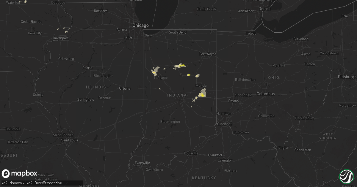
Hail Map in Indiana on June 7, 2018
Get this storm
June 7 map
$229
one time, instant access
Download today. No call, no setup
Keep the $229
Bought the map and want the full workflow? Apply the entire $229 to a subscription within 7 days. None of it is wasted.
Every map, not just this one
This buys you this map. Subscription and you get every map we run, in the markets you choose from a few cities to whole states to nationwide. Plus real-time alerts the moment a storm fires.
Contact data
Name, contact info, occupancy, even credit band for addresses in the footprint. You go from where it hit to who to call.
Become the source they trust
Unlimited branding weather history reports on demand. You already have the documented answer ready for the property owner, and you are the one who showed up with it.
Property data and RoofTrace estimates
Pull up any address you have got, its value and the exact code rules for that jurisdiction, straight from One Click Code. Then RoofTrace estimates the squares, pitch, and roof value, priced the way you price.
Storm reports in Indiana
Indiana
| Date | Description |
|---|---|
| 06/07/20186:30 PM CDT | A couple smaller trees down and a small outbuilding destroyed on cr 350 n. Found this morning so time estimated. |
| 06/07/20185:33 PM CDT | A local report indicates 1.00 inch wind near PERU |
| 06/07/20182:25 AM CDT | At 725 PM EDT, a severe thunderstorm was located over West Lafayette, or near Lafayette, moving east at 15 mph. HAZARD...60 mph wind gusts and penny size hail. SOURCE...Radar indicated. IMPACT...Expect damage to roofs, siding, and trees. Locations impacted include... Lafayette, West Lafayette, Shadeland, Dayton, Battle Ground, Clarks Hill and Purdue University.This includes Interstate 65 between mile markers 162 and 180. |
| 06/07/20182:12 AM CDT | At 712 PM EDT, a severe thunderstorm was located near Mexico, or near Peru, moving east at 15 mph. HAZARD...Quarter size hail. SOURCE...Trained weather spotters report penny sized hail west of Peru. IMPACT...Damage to vehicles is expected. Locations impacted include... Peru, Mexico, Wells, Denver, Chili and Nead. |
| 06/07/20181:44 AM CDT | At 644 PM EDT, a severe thunderstorm was located over Logansport, moving east at 10 mph. HAZARD...Quarter size hail. SOURCE...Radar indicated. IMPACT...Damage to vehicles is expected. Locations impacted include... Logansport, Walton, Onward, Hoover, New Waverly, Adamsboro and Anoka. |
| 06/07/20181:42 AM CDT | At 640 PM EDT, a severe thunderstorm was located over Peru, moving east at 10 mph. HAZARD...Quarter size hail. SOURCE...Emergency Management reported from Peru at 633 PM EDT IMPACT...Damage to vehicles is expected. Locations impacted include... Wabash, Erie, Richvalley, Somerset and Peoria. |
| 06/06/20188:00 PM CDT | Reports of quarter size hail via twitter. Time estimated from radar. |
| 06/06/20187:23 PM CDT | A tree down with lightning strike reported. Time estimated via radar. |
All States Impacted by Hail Map on June 7, 2018
Cities Impacted by Hail Map on June 7, 2018
- Merriman, NE
- Gordon, NE
- Capulin, NM
- Des Moines, NM
- Hayes, SD
- Gainesville, TX
- Fort Pierre, SD
- Colorado City, TX
- Loraine, TX
- Merkel, TX
- Tuscola, TX
- Wingate, TX
- Blackwell, TX
- Trent, TX
- Nolan, TX
- Sweetwater, TX
- Dix, NE
- Harrisburg, NE
- Folsom, NM
- Silverton, TX
- Booneville, AR
- Deadwood, SD
- Lead, SD
- Thompson, IA
- Forest City, IA
- Buffalo Center, IA
- Galata, MT
- Dickens, TX
- Belle Fourche, SD
- Perry, OK
- Hartley, TX
- Tecumseh, OK
- Shawnee, OK
- Denton, TX
- Richey, MT
- Lusk, WY
- Hardin, MT
- Terry, MT
- Ryegate, MT
- Lavina, MT
- Shawmut, MT
- Grass Range, MT
- Roundup, MT
- Judith Gap, MT
- Estero, FL
- Fort Myers, FL
- Ismay, MT
- Redstone, MT
- Flaxville, MT
- Blanchard, OK
- Alex, OK
- Lodge Grass, MT
- Bassett, NE
- Whitman, NE
- Hyannis, NE
- Forsyth, MT
- Burwell, NE
- Lambert, MT
- Poplar, MT
- Bloomfield, MT
- Froid, MT
- Brockton, MT
- Circle, MT
- West Lafayette, IN
- Umpire, AR
- Birney, MT
- Oshkosh, NE
- Crowell, TX
- Loring, MT
- Rochester, TX
- Rule, TX
- Knox City, TX
- Old Glory, TX
- O'Brien, TX
- Paducah, TX
- Seymour, TX
- Bighorn, MT
- Independence, IA
- Matador, TX
- Norman, OK
- Newalla, OK
- Irving, TX
- Dallas, TX
- Mill Creek, OK
- Ardmore, OK
- Mannsville, OK
- Whitetail, MT
- Whitewood, SD
- Busby, MT
- Vale, SD
- Hermleigh, TX
- Snyder, TX
- Roscoe, TX
- Maryneal, TX
- Hulett, WY
- Ideal, SD
- Hamill, SD
- Otterbein, IN
- Oxford, IN
- Fowler, IN
- Oklahoma City, OK
- Newcastle, OK
- Lindsay, OK
- Amber, OK
- Chickasha, OK
- Woden, IA
- Gas City, IN
- Upland, IN
- Tell, TX
- Childress, TX
- Otter, MT
- Oviedo, FL
- Hawley, TX
- Abilene, TX
- Pueblo, CO
- Billings, MT
- Clarksville, TX
- Vero Beach, FL
- Anna, TX
- Jay Em, WY
- Aspermont, TX
- Wilmont, MN
- Stamford, TX
- Scobey, MT
- Garryowen, MT
- Amelia, NE
- Edmond, OK
- Swayzee, IN
- Greentown, IN
- Lindsay, MT
- Bridger, MT
- Fort Smith, MT
- Verden, OK
- Anadarko, OK
- Clyde, TX
- Rosston, TX
- Sanger, TX
- Saint Jo, TX
- Era, TX
- Muenster, TX
- Rushville, NE
- Wagner, SD
- Bridgeport, NE
- Carbon, TX
- Gorman, TX
- Wall, SD
- Luther, OK
- Wellston, OK
- Johnstown, NE
- Muncie, IN
- Munday, TX
- Roberts, MT
- Red Lodge, MT
- Nisland, SD
- Newell, SD
- Sturgis, SD
- Yukon, OK
- Mcloud, OK
- Antelope, MT
- Cement, OK
- Cyril, OK
- Anson, TX
- Lueders, TX
- Avoca, TX
- Albany, TX
- Northwood, IA
- Turkey, TX
- Plentywood, MT
- Reserve, MT
- Lame Deer, MT
- Gillham, AR
- Hartville, WY
- Glendo, WY
- Rosebud, MT
- Gurley, NE
- Hendrix, OK
- Bonham, TX
- Savoy, TX
- Whitewright, TX
- Ravenna, TX
- Colbert, OK
- Ector, TX
- Calera, OK
- Osteen, FL
- Lake Dallas, TX
- Buffalo, WY
- Big Sandy, MT
- Lewellen, NE
- Southlake, TX
- Grapevine, TX
- Lockney, TX
- Aubrey, TX
- Pilot Point, TX
- Faith, SD
- Dupree, SD
- Lismore, MN
- Quail, TX
- Foster, OK
- Peru, IN
- Logansport, IN
- New Waverly, IN
- Walton, IN
- Paris, TX
- Roxton, TX
- Haskell, TX
- Justin, TX
- Ponder, TX
- Argyle, TX
- Ainsworth, NE
- Clancy, MT
- Girard, TX
- Big Timber, MT
- Henry, IL
- Quitaque, TX
- Clarendon, TX
- Lakeview, TX
- Sylvester, TX
- Channing, TX
- Jayton, TX
- Rotan, TX
- Crow Agency, MT
- Carney, OK
- Goree, TX
- Lewistown, MT
- Hilger, MT
- Stillwater, OK
- Point, TX
- Winner, SD
- Valley View, TX
- Carrollton, TX
- Kinsey, MT
- Lake Mills, IA
- Hanlontown, IA
- Kensett, IA
- Meeker, OK
- Boyes, MT
- Gering, NE
- Newport, NE
- Long Pine, NE
- Tryon, OK
- Tye, TX
- Dyess Afb, TX
- Wolf Point, MT
- Strasburg, CO
- Byers, CO
- Red Oak, OK
- Grannis, AR
- Wickes, AR
- Cisco, TX
- Orlando, OK
- Lucien, OK
- Leonard, TX
- Quanah, TX
- New Castle, IN
- Livingston, MT
- Erie, IL
- Crescent, OK
- Marshall, OK
- Cordova, IL
- Camp Crook, SD
- Milesville, SD
- Spur, TX
- Midland, SD
- Lake Andes, SD
- Grenville, NM
- Celeste, TX
- Harrison, NE
- Devol, OK
- Black Hawk, SD
- Coyle, OK
- Okarche, OK
- Wolcott, IN
- Reynolds, IN
- Remington, IN
- Brookston, IN
- Chalmers, IN
- Texarkana, TX
- Montague, TX
- Nocona, TX
- Straughn, IN
- Knightstown, IN
- Mooreland, IN
- Hagerstown, IN
- Middletown, IN
- Selma, IN
- Springport, IN
- Losantville, IN
- Dalhart, TX
- Fletcher, OK
- Edgemont, SD
- Ninnekah, OK
- Shelby, MT
- Hammond, MT
- Charlottesville, IN
- Shirley, IN
- Wilkinson, IN
- Mulhall, OK
- Durant, OK
- Geneva, FL
- Christmas, FL
- Nemo, SD
- Dierks, AR
- Westby, MT
- Harrah, OK
- Shelbyville, IN
- Covington, OK
- Fallon, MT
- Miles City, MT
- Bradley, OK
- Crawfordsville, IN
- Princeton, IL
- Marion, IN
- Jonesboro, IN
- Fairmount, IN
- Hartford City, IN
- Lisco, NE
- Custer, MT
- Meadow, SD
- Bison, SD
- Calamus, IA
- Grand Mound, IA
- Tulia, TX
- Sebastian, FL
- Fort Lauderdale, FL
- Hollywood, FL
- Roaring Springs, TX
- Hereford, TX
- Sulphur Springs, TX
- Brashear, TX
- Cumby, TX
- Kaycee, WY
- Greenfield, IN
- Ada, OK
- Konawa, OK
- Forest Grove, MT
- Ekalaka, MT
- Broadwater, NE
- Little Elm, TX
- Wabash, IN
- Hugo, CO
- Hettinger, ND
- New England, ND
- Regent, ND
- Camanche, IA
- Albany, IL
- Richland, MT
- Gladstone, NM
- Arthur, NE
- Homestead, MT
- Sunburst, MT
- Enid, OK
- Kremlin, OK
- Princeton, IA
- Le Claire, IA
- Vida, MT
- Fellsmere, FL
- Van Tassell, WY
- Dickinson, ND
- New Underwood, SD
- Owanka, SD
- Wasta, SD
- Howes, SD
- Madill, OK
- Fairfax, SD
- Pickstown, SD
- Torrington, WY
- Hillsdale, IL
- Bagwell, TX
- Detroit, TX
- Hereford, OR
- Annona, TX
- Blossom, TX
- Yeoman, IN
- Monticello, IN
- Delphi, IN
- Sulphur, OK
- Lone Oak, TX
- Chadron, NE
- Rush Springs, OK
- Fulda, MN
- Broken Bow, OK
- Krum, TX
- Prague, OK
- Bartlesville, OK
- Pawhuska, OK
- Waterloo, IA
- Dunkerton, IA
- Jesup, IA
- Wayside, TX
- Jackson, MN
- Lakefield, MN
- Hazleton, IA
- Hooks, TX
- Chambers, NE
- Ewing, NE
- Philip, SD
- De Witt, IA
- Streator, IL
- Commerce, TX
- Decker, MT
- Joice, IA
- Sheffield, IL
- Afton, TX
- Mcadoo, TX
- Princeton, TX
- Mckinney, TX
- Oilmont, MT
- Grandfield, OK
- Choctaw, OK
- Galveston, IN
- Onward, IN
- Valliant, OK
- Clayton, NM
- El Reno, OK
- Presho, SD
- Spencer, OK
- Piedmont, OK
- Jones, OK
- Bethany, OK
- Capitol, MT
- Kokomo, IN
- Belfry, MT
- Anchor, IL
- Hamlin, TX
- Clearmont, WY
- Vega, TX
- Douglas, OK
- Nye, MT
- Nash, TX
- Tussy, OK
- Ratliff City, OK
- Weinert, TX
- Lindsay, TX
- Winston, MT
- Biddle, MT
- Prairie City, SD
- Maud, OK
- Manly, IA
- Mason City, IA
- Kress, TX
- Crawford, NE
- Cherry Creek, SD
- Happy, TX
- Fromberg, MT
- Carthage, IN
- Bixby, OK
- Haskell, OK
- Bridgeport, OR
- Brule, NE
- Chandler, OK
- Alva, WY
- Greenville, TX
- Hedley, TX
- Elmore City, OK
- Union, IA
- De Queen, AR
- Wyola, MT
- Medicine Lake, MT
- Fairview, MT
- Culbertson, MT
- Douglas, WY
- Shawnee, WY


