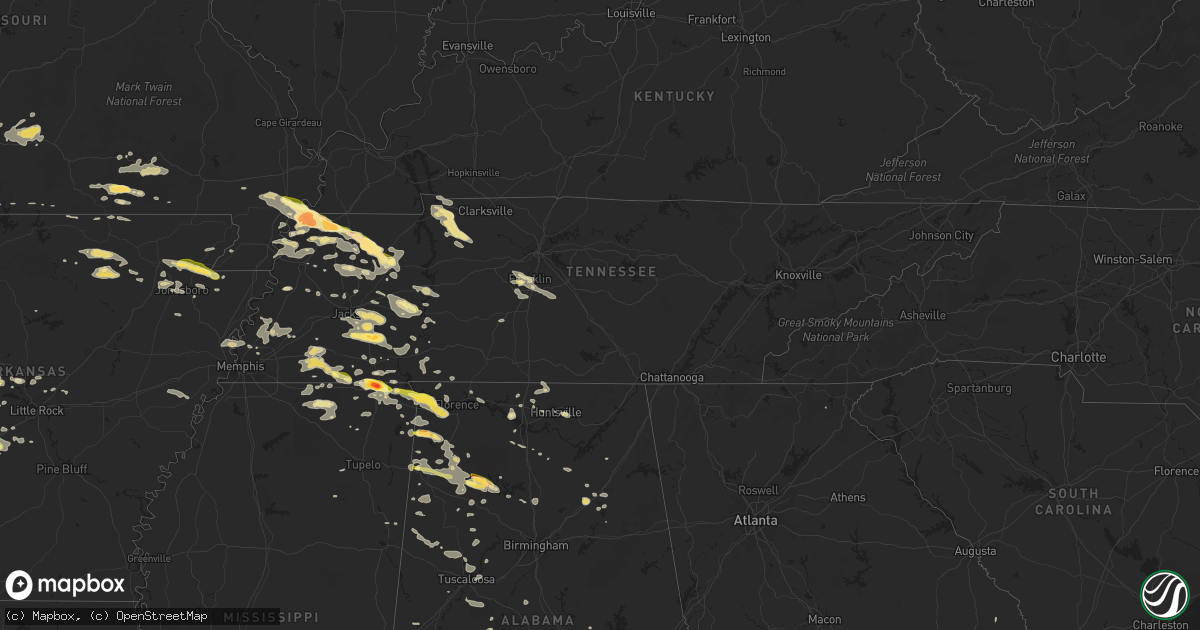
Hail Map in Tennessee on June 7, 2014
Get this storm
June 7 map
$229
one time, instant access
Download today. No call, no setup
Keep the $229
Bought the map and want the full workflow? Apply the entire $229 to a subscription within 7 days. None of it is wasted.
Every map, not just this one
This buys you this map. Subscription and you get every map we run, in the markets you choose from a few cities to whole states to nationwide. Plus real-time alerts the moment a storm fires.
Contact data
Name, contact info, occupancy, even credit band for addresses in the footprint. You go from where it hit to who to call.
Become the source they trust
Unlimited branding weather history reports on demand. You already have the documented answer ready for the property owner, and you are the one who showed up with it.
Property data and RoofTrace estimates
Pull up any address you have got, its value and the exact code rules for that jurisdiction, straight from One Click Code. Then RoofTrace estimates the squares, pitch, and roof value, priced the way you price.
Storm reports in Tennessee
Tennessee
| Date | Description |
|---|---|
| 06/07/20146:58 PM CDT | Trees down near shelby county line. |
| 06/07/20146:55 PM CDT | Large trees reportedly blown down near eagleville |
| 06/07/20146:42 PM CDT | Trees and powerlines down. |
| 06/07/20146:40 PM CDT | Several trees down. |
| 06/07/20146:38 PM CDT | Few trees and limbs down |
| 06/07/20146:30 PM CDT | A few trees down across county. |
| 06/07/20146:30 PM CDT | Large tree limbs down. Big trees down on d st...n missouri st...butlet st...and rains springs rd. Power outage. |
| 06/07/20146:30 PM CDT | Trees snapped uprooted with estimated winds of 70 mph. |
| 06/07/20146:25 PM CDT | Emergency manager reports at least a dozen trees down across the county with over 5000 residents without power. Some downed power lines were live or hot. |
| 06/07/20146:20 PM CDT | Concentrated tree damage...limbs and trees in a small area near 421 scarborough lane. Possible tornado touchdown. Public reported loud train noise. A neighbor had picku |
| 06/07/20146:16 PM CDT | 60 to 70 mph wind reported. |
| 06/07/20146:00 PM CDT | 6200 block of highway 188- 2 sheds destroyed and part of another shop.a few trees down. |
| 06/07/20145:40 PM CDT | Trees and powerlines down across the county...although gleason was the hardest hit. |
| 06/07/20145:26 PM CDT | A local report indicates 1.00 inch wind near PARSONS |
| 06/07/20145:20 PM CDT | Multiple trees down in southern and eastern houston county. |
| 06/07/20145:20 PM CDT | Large hail...golf ball sized. |
| 06/07/20145:10 PM CDT | Numerous trees down. |
| 06/07/20144:55 PM CDT | Estimated wind gust 65 mph blew a semi truck off road. |
| 06/07/20144:50 PM CDT | Large tree fell on house. |
| 06/07/20144:49 PM CDT | A local report indicates 1.50 inch wind near HENDERSON |
| 06/07/20144:47 PM CDT | Deer processing plant and browns meat market extensive damage. Possible tornado damage. |
| 06/07/20144:05 PM CDT | Hail started as quarter sized then rapidly increased to golfball size. |
| 06/07/20143:51 PM CDT | A local report indicates 2.75 inch wind near N SAMBURG |
| 06/07/20143:50 PM CDT | 10 houses damaged. 15 roads blocked by fallen trees. Several trees down on houses and barns. Possible tornado tracked from just north of samburg and across possumtrot.. |
| 06/07/20143:50 PM CDT | Numerous trees and power lines down. |
| 06/07/20143:35 PM CDT | Tornado on ground near clayton moving towards union city |
| 06/06/20149:00 PM CDT | Trees and power lines reported down across the county |
| 06/06/20148:55 PM CDT | Trees down reported in mount pleasant near main street. Not blocking any roadways. |
| 06/06/20148:30 PM CDT | Several trees down blocking highway 100 just east of highway 22 west of scotts hill. |
| 06/06/20148:22 PM CDT | A tree was reported down in lawrenceburg. |
| 06/06/20148:15 PM CDT | A few trees were blown down near holly creek. |
| 06/06/20148:15 PM CDT | Trees down at stewarts ferry pike and logue road near gladeville. |
| 06/06/20148:15 PM CDT | Numerous trees and power lines were blown down in spring hill in maury county...including on beechcroft road and kedron road. A tree fell on a car on main street. 11 po |
| 06/06/20148:10 PM CDT | Several trees down in huntingdon area. |
| 06/06/20148:05 PM CDT | A tree was reported down on rucker christiana road blocking the roadway. |
| 06/06/20147:40 PM CDT | A few trees were down across southern perry county. |
| 06/06/20147:12 PM CDT | Roof damage to homes and businesses. |
| 06/06/20147:00 PM CDT | Numerous trees down along highway 88. Some power lines down. |
| 06/06/20147:00 PM CDT | Numerous trees and power lines down all around parsons. |
| 06/06/20147:00 PM CDT | Trees and power lines down. |
All States Impacted by Hail Map on June 7, 2014
Cities Impacted by Hail Map on June 7, 2014
- Plainview, TX
- Hale Center, TX
- Lawton, OK
- Fremont, MO
- Van Buren, MO
- Anton Chico, NM
- Lamont, FL
- Noble, OK
- Norman, OK
- Roswell, NM
- Haleyville, AL
- Bear Creek, AL
- Malvern, AR
- Muleshoe, TX
- Corona, NM
- Pecos, NM
- Ribera, NM
- Glorieta, NM
- Adona, AR
- Perry, AR
- Tucumcari, NM
- Portales, NM
- Sudan, TX
- Coleman, OK
- Beech Bluff, TN
- Jackson, TN
- Luray, TN
- Huron, TN
- Toney, AL
- Sugar Tree, TN
- Coalgate, OK
- Atoka, OK
- Barstow, TX
- Pecos, TX
- Balmorhea, TX
- Mountain Grove, MO
- Hartville, MO
- Mansfield, MO
- Graff, MO
- Norwood, MO
- Hedley, TX
- Lelia Lake, TX
- Clarendon, TX
- Pembroke, GA
- Brooklet, GA
- Casper, WY
- Shoshoni, WY
- Mena, AR
- Lovington, NM
- San Jose, NM
- Santa Fe, NM
- Tererro, NM
- Clayton, OK
- Seminole, TX
- Franklin, TN
- Plains, TX
- Hatfield, AR
- Conway, AR
- Mayflower, AR
- Whiteville, TN
- Somerville, TN
- Ripley, TN
- Brighton, TN
- Defuniak Springs, FL
- Levelland, TX
- Sundown, TX
- Capitan, NM
- Crestview, FL
- Wilson, OK
- Ringling, OK
- Ryan, OK
- Clayton, NM
- Roy, NM
- Dimmitt, TX
- Hart, TX
- Alamo, TN
- Friona, TX
- Baker, FL
- Tatum, NM
- Greenwood, AR
- Huntington, AR
- Booneville, AR
- Quinton, OK
- Kinta, OK
- Sulphur, OK
- Bethel Springs, TN
- Finger, TN
- Medon, TN
- Lexington, TN
- Pinson, TN
- Denmark, TN
- Henderson, TN
- Adamsville, TN
- Enville, TN
- Morris Chapel, TN
- Quail, TX
- Nocona, TX
- Childress, TX
- Greenfield, TN
- Lexington, OK
- Wanette, OK
- Hanna, OK
- Lockney, TX
- Quitaque, TX
- Mannsville, OK
- Mill Creek, OK
- Ardmore, OK
- Cuervo, NM
- Conchas Dam, NM
- Ramer, TN
- Corinth, MS
- Sedalia, CO
- Brent, AL
- Holdenville, OK
- Wewoka, OK
- Seminole, OK
- Marion, AL
- Springer, NM
- Electra, TX
- Marshfield, MO
- Seymour, MO
- Birch Tree, MO
- Winona, MO
- Rule, TX
- Ravenden, AR
- Mammoth Spring, AR
- Davidson, OK
- New Concord, KY
- Caruthersville, MO
- Ridgely, TN
- Dyersburg, TN
- Hayti, MO
- Newbern, TN
- Obion, TN
- Sasakwa, OK
- Olustee, OK
- Gould, OK
- Mosquero, NM
- Eagle Nest, NM
- Gadsden, AL
- Rainbow City, AL
- Ashville, AL
- Kim, CO
- Fletcher, OK
- Marlow, OK
- Ola, AR
- Casa, AR
- Danville, AR
- Dardanelle, AR
- Morrilton, AR
- Grand Junction, TN
- Williston, TN
- Walnut, MS
- Moscow, TN
- Pocahontas, TN
- Saulsbury, TN
- Hickory Valley, TN
- Middleton, TN
- Bolivar, TN
- Trementina, NM
- Las Animas, CO
- Konawa, OK
- Hereford, TX
- Cuba, AL
- Lauderdale, MS
- Wetumka, OK
- Maud, OK
- Elgin, OK
- Las Vegas, NM
- Sapello, NM
- Perry, FL
- Mayo, FL
- Ratliff City, OK
- Tussy, OK
- Hennepin, OK
- Thompsons Station, TN
- Columbia, TN
- Spring Hill, TN
- Brownfield, TX
- Tahoka, TX
- Meadow, TX
- Farwell, TX
- Double Springs, AL
- Arley, AL
- Temple, OK
- Randlett, OK
- Wellington, TX
- Salem, SC
- Duncan, OK
- Matador, TX
- Odonnell, TX
- Lamesa, TX
- Arlington, CO
- Karval, CO
- Huntsville, AL
- Apache, OK
- Steele, AL
- Newkirk, NM
- Colquitt, GA
- Quanah, TX
- Eldorado, OK
- Kenton, TN
- Rutherford, TN
- Dyer, TN
- Bono, AR
- Lake City, AR
- Paragould, AR
- Newalla, OK
- Mcloud, OK
- Hot Springs Village, AR
- Lonsdale, AR
- Elmore City, OK
- Cullman, AL
- Baileyton, AL
- Fort Davis, TX
- Selmer, TN
- Post, TX
- Slaton, TX
- Lenorah, TX
- Ackerly, TX
- Clovis, NM
- Knott, TX
- Greenville, FL
- Tiptonville, TN
- Hickman, KY
- Union City, TN
- Troy, TN
- Hornbeak, TN
- New Madrid, MO
- Stigler, OK
- Eufaula, OK
- Atwood, TN
- Chillicothe, TX
- Duke, OK
- Vernon, TX
- Odell, TX
- Denver City, TX
- Walnut Ridge, AR
- Cash, AR
- Ashland, MS
- Ripley, MS
- Evening Shade, AR
- Ash Flat, AR
- Brownsboro, AL
- Owens Cross Roads, AL
- Gurley, AL
- Jemez Springs, NM
- Mcalester, OK
- Russellville, AL
- Red Bay, AL
- Burneyville, OK
- Ropesville, TX
- Michie, TN
- Burnsville, MS
- Newton, GA
- Decatur, AL
- Millington, TN
- Gleason, TN
- Rives, TN
- Springer, OK
- Beaverton, AL
- Carter, OK
- Sayre, OK
- Parsons, TN
- Darden, TN
- Texico, NM
- Glen, MS
- Milton, FL
- Jay, FL
- Killen, AL
- Uriah, AL
- Atmore, AL
- Michigan City, MS
- Atwood, OK
- Calvin, OK
- Allen, OK
- Milburn, OK
- Hayden, AL
- Warrior, AL
- Cherokee, AL
- Dennis, MS
- Tishomingo, MS
- Magazine, AR
- Hollis, OK
- Loveland, OK
- Chattanooga, OK
- Jasper, AL
- Bremen, AL
- Crane Hill, AL
- Bainbridge, GA
- Climax, GA
- Alpine, TX
- Nauvoo, AL
- Dover, AR
- Anton, TX
- Hardy, AR
- Poughkeepsie, AR
- Smithville, AR
- Franklin, AR
- Violet Hill, AR
- Horseshoe Bend, AR
- Decorah, IA
- Hanceville, AL
- Lubbock, TX
- Canal Point, FL
- Wolfforth, TX
- Martin, TN
- Hartselle, AL
- Danville, AL
- Brilliant, AL
- Lynn, AL
- Spruce Pine, AL
- Vina, AL
- Hamilton, AL
- Phil Campbell, AL
- Hackleburg, AL
- Newington, GA
- Springfield, GA
- Guyton, GA
- Clyo, GA
- Alton, MO
- Raton, NM
- Mountain View, OK
- Ralph, AL
- Houston, AR
- Bigelow, AR
- Perryville, AR
- Dexter, MO
- Dresden, TN
- Henry, TN
- Sharon, TN
- Lilbourn, MO
- McKenzie, TN
- Huntingdon, TN
- Memphis, TN
- Santa Rosa, NM
- Altus, OK
- Kress, TX
- Detroit, AL
- Stuart, OK
- Buena Vista, NM
- Mora, NM
- Ocate, NM
- Cleveland, NM
- Pauls Valley, OK
- Iuka, MS
- Tanner, AL
- Athens, AL
- Dodson, TX
- Melrose, NM
- Mcalister, NM
- Grady, NM
- Ohatchee, AL
- Tuscumbia, AL
- Lonoke, AR
- Cabot, AR
- Haskell, TX
- Stamford, TX
- Amistad, NM
- Black, AL
- Fort White, FL
- O'Brien, FL
- Branford, FL
- Linden, TN
- Nazareth, TX
- Mason, TN
- Plainview, AR
- Macomb, MO
- Gail, TX
- Waldron, AR
- Harvey, AR
- Parks, AR
- Gravelly, AR
- Estancia, NM
- Berry, AL
- La Grange, TN
- Amherst, TX
- Earth, TX
- Fieldton, TX
- Littlefield, TX
- Fort Sumner, NM
- Bay, AR
- Northport, AL
- Brookwood, AL
- Wilson, TX
- Wink, TX
- Pyote, TX
- Monahans, TX
- Wetumpka, AL
- Bradford, TN
- Bovina, TX
- Westcliffe, CO
- Hodgen, OK
- Heavener, OK
- Couch, MO
- Panhandle, TX
- Black River Falls, WI
- Sparta, WI
- Smithville, OK
- Erin, TN
- Dover, TN
- Tennessee Ridge, TN
- Indian Mound, TN
- Vanleer, TN
- Cumberland City, TN
- Turrell, AR
- Morton, TX
- West Salem, WI
- Seymour, TX
- Branson, CO
- Rush Springs, OK
- Frederick, OK
- Lorenzo, TX
- Memphis, TX
- Jonesboro, AR
- Elida, NM
- Monette, AR
- Leachville, AR
- Beech Grove, AR
- Cave City, AR
- Garita, NM
- Elmer, OK
- Savannah, TN
- Abernathy, TX
- Shallowater, TX
- Hobbs, NM
- Smyer, TX
- Andrews, TX
- Tokio, TX
- Seagraves, TX
- Hagerman, NM
- Tecumseh, OK
- Foster, OK
- Paducah, TX
- Floydada, TX
- Roaring Springs, TX
- Traskwood, AR
- Eustis, FL
- Florence, AL
- Rogersville, MO
- Petrolia, TX
- Weiner, AR
- Harrisburg, AR
- Cove, AR
- Vandervoort, AR
- Tallahassee, FL
- Melbourne, AR
- Cottondale, AL
- Tuscaloosa, AL
- Ada, OK
- Briggsville, AR
- Walters, OK
- Glennville, GA
- Batesville, AR
- Strawberry, AR
- Sidney, AR
- Sulphur Rock, AR
- Stratford, OK
- Paoli, OK
- Petersburg, TX
- Claxton, GA
- Moundville, AL
- Shiloh, TN
- Guys, TN
- Idalou, TX
- Millport, AL
- Epes, AL
- Monticello, FL
- Tremont, MS
- Belmont, MS
- Antlers, OK
- Fort Sill, OK
- Trenton, TN
- Watson, OK
- Almo, KY
- Murray, KY
- Stewart, TN
- Davis, OK
- Holladay, TN
- Lobelville, TN
- Rogersville, AL
- Ponce De Leon, FL
- Meigs, GA
- Lindsay, OK
- Ordway, CO
- Mclean, TX
- Los Alamos, NM
- Warrens, WI
- Tomah, WI
- Black Oak, AR
- Russellville, AR
- Falkner, MS
- Blue Mountain, MS
- Blanchard, OK
- Altoona, AL
- Tishomingo, OK
- Kenefic, OK
- Crowell, TX
- McEwen, TN
- Hattieville, AR
- Lamy, NM
- Milan, TN
- Ozark, AR
- Vilonia, AR
- Elkmont, AL
- Gainesville, MO
- Isabella, MO
- Marianna, AR
- Forrest City, AR
- Haynes, AR
- Brickeys, AR
- Lysite, WY
- Bruceton, TN
- Hollow Rock, TN
- Spring Grove, MN
- Mabel, MN
- Henrietta, TX
- Mayfield, KY
- Lutts, TN
- Hernandez, NM
- Hot Springs National Park, AR
- Roff, OK
- Hamilton, MS
- Gallant, AL
- Welch, TX
- York, AL
- Myrtle, MS
- Holly Springs, MS
- Hickory Flat, MS
- Decaturville, TN
- Wildersville, TN
- Scotts Hill, TN
- Jacksonville, AR
- Little Rock Air Force Base, AR
- Hasty, CO
- Red Oak, OK
- Titus, AL
- Madill, OK
- Atoka, TN
- Rover, AR
- Bath Springs, TN
- Paron, AR
- Little Rock, AR
- Falkville, AL
- Valmora, NM
- Sulligent, AL
- Vernon, AL
- Shirley, AR
- Macomb, OK
- Throckmorton, TX
- Portageville, MO
- Olivehill, TN
- Townley, AL
- Carbon Hill, AL
- Terral, OK
- Watrous, NM
- Waynesboro, TN
- Clifton, TN
- Havana, AR
- Mansfield, AR
- Fort Smith, AR
- Charleston, AR
- Attalla, AL
- Tipton, OK
- Gadsden, TN
- Humboldt, TN
- Ocala, FL
- Counce, TN
- Heidelberg, MS
- Laurel, MS
- Keota, OK
- Cuba, NM
- Farmington, KY
- Kirksey, KY
- Doniphan, MO
- Grandin, MO
- Paris, AR
- Rienzi, MS
- Pontotoc, MS
- Caledonia, MN
- Roosevelt, OK
- Blue Mountain, AR
- Lone Wolf, OK
- Ardmore, TN
- Ardmore, AL
- Hazel Green, AL
- Taft, TN
- Mount Pleasant, TN
- Medina, TN
- West Plains, MO
- McClave, CO
- Washington, OK
- Halls, TN
- Benton, AR
- Camilla, GA
- White Rock, NM
- Opp, AL
- Iron City, TN
- Tulia, TX
- Lakeview, TX
- Sylvania, GA
- Randolph, AL
- Brierfield, AL
- Summerfield, TX
- Hardenville, MO
- Tecumseh, MO
- Reagan, TN
- Booneville, MS
- Equality, AL
- Bryant, AR
- Trezevant, TN
- Alicia, AR
- Byers, TX
- Bardwell, KY
- Arlington, KY
- Stanton, TN
- Drummonds, TN
- Arlington, TN
- Burlison, TN
- Covington, TN
- Munford, TN
- Kennedy, AL
- Theodosia, MO
- Hartford, AR
- Golden, MS
- Dougherty, OK
- Poyen, AR
- Westport, TN
- Varnville, SC
- Cresco, IA
- Saint Jo, TX
- Harvest, AL
- Addison, AL
- Norman, AR
- Knox City, TX
- Hornsby, TN
- Cedar Grove, TN
- Hartsfield, GA
- Prattville, AL
- Eldridge, AL
- Bankston, AL
- Senath, MO
- Autaugaville, AL
- Buena Vista, TN
- Mansfield, TN
- Marston, MO
- Parma, MO
- Lavinia, TN
- Catron, MO
- Leon, OK
- Healdton, OK
- Honoraville, AL
- Luverne, AL
- Munday, TX
- Viola, AR
- Salem, AR
- Sturkie, AR
- Eagleville, TN
- College Grove, TN
- Rockvale, TN
- Bumpus Mills, TN
- Big Rock, TN
- Wichita Falls, TX
- Broadview, NM
- Atkins, AR
- Boles, AR
- Mountain Pine, AR
- Bauxite, AR
- Reform, AL
- Fayette, AL
- Samson, AL
- Dumas, MS
- Melrose, WI
- Lamar, MS
- Marietta, OK
- Koshkonong, MO
- Thayer, MO
- Guin, AL
- Caulfield, MO
- Marmaduke, AR
- Espanola, NM
- Sheridan, AR
- Lynn, AR
- Sherwood, AR
- West Union, SC
- Walhalla, SC
- Fancy Farm, KY
- Stantonville, TN
- Shawnee, OK
- Urbana, MO
- Elrod, AL
- Brewton, AL
- Westminster, SC
- Houston, MS
- Waterloo, AL
- Horton, AL
- Blountsville, AL
- Guntersville, AL
- Clarkesville, GA
- Eva, AL
- Tiplersville, MS
- Riverton, WY
- Pavillion, WY
- Long Lane, MO
- Buffalo, MO
- Windyville, MO
- Justiceburg, TX
- Crossville, AL
- Madison, AL
- Houston, AL
- Silverton, TX
- Overbrook, OK
- Mcdonald, NM


