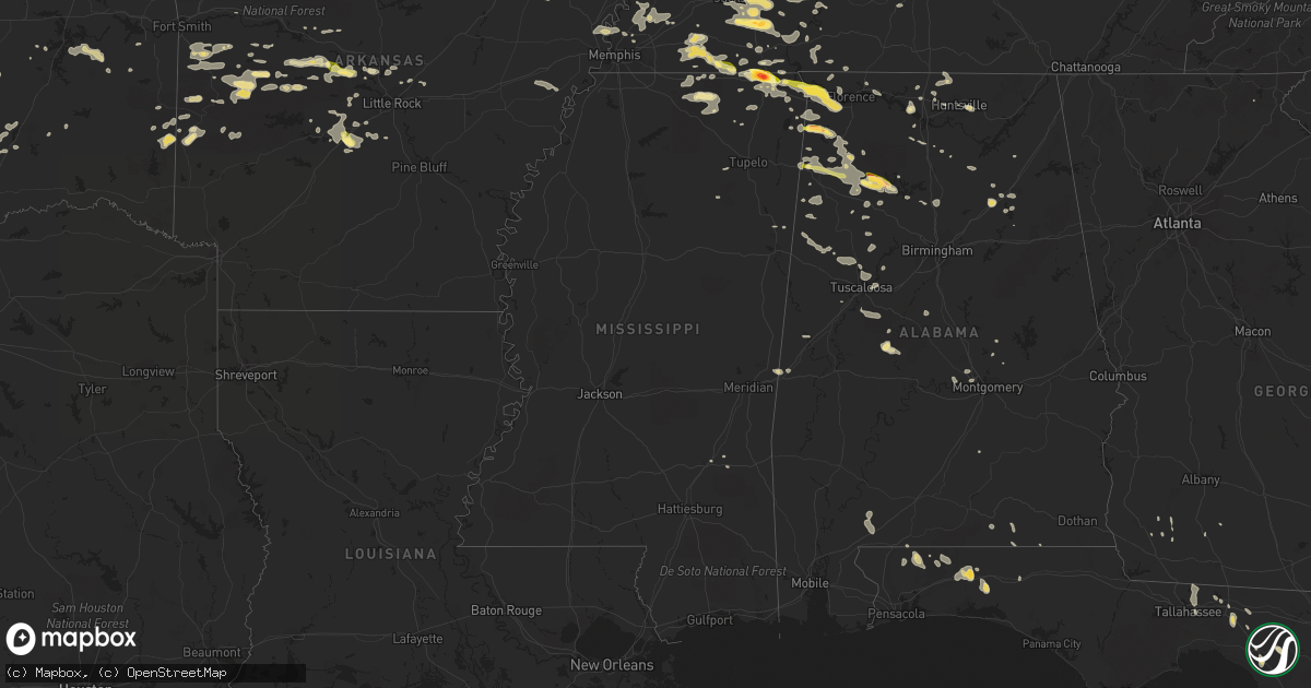
Hail Map in Mississippi on June 7, 2014
Get this storm
June 7 map
$229
one time, instant access
Download today. No call, no setup
Keep the $229
Bought the map and want the full workflow? Apply the entire $229 to a subscription within 7 days. None of it is wasted.
Every map, not just this one
This buys you this map. Subscription and you get every map we run, in the markets you choose from a few cities to whole states to nationwide. Plus real-time alerts the moment a storm fires.
Contact data
Name, contact info, occupancy, even credit band for addresses in the footprint. You go from where it hit to who to call.
Become the source they trust
Unlimited branding weather history reports on demand. You already have the documented answer ready for the property owner, and you are the one who showed up with it.
Property data and RoofTrace estimates
Pull up any address you have got, its value and the exact code rules for that jurisdiction, straight from One Click Code. Then RoofTrace estimates the squares, pitch, and roof value, priced the way you price.
Storm reports in Mississippi
Mississippi
| Date | Description |
|---|---|
| 06/07/20145:46 PM CDT | Very large hail 21/2 inches in corinth |
| 06/07/20145:38 PM CDT | Hail was falling near tennessee/mississippi border. |
| 06/06/20149:35 PM CDT | Two houses with major damage including a roof off...two additional houses with minor damage. Trees down. |
| 06/06/20149:00 PM CDT | In lafayette county a few trees have been blown down and a few power outages reported. |
| 06/06/20148:30 PM CDT | Some trees and large limbs down between southaven and walls. |
| 06/06/20148:30 PM CDT | Estimated 60 mph winds kicked dirt up and knocked a child over in a ball field. |
| 06/06/20147:54 PM CDT | A local report indicates 1.75 inch wind near CORINTH |
| 06/06/20147:05 PM CDT | Trees and power lines down in town. |
All States Impacted by Hail Map on June 7, 2014
Cities Impacted by Hail Map on June 7, 2014
- Plainview, TX
- Hale Center, TX
- Lawton, OK
- Fremont, MO
- Van Buren, MO
- Anton Chico, NM
- Lamont, FL
- Noble, OK
- Norman, OK
- Roswell, NM
- Haleyville, AL
- Bear Creek, AL
- Malvern, AR
- Muleshoe, TX
- Corona, NM
- Pecos, NM
- Ribera, NM
- Glorieta, NM
- Adona, AR
- Perry, AR
- Tucumcari, NM
- Portales, NM
- Sudan, TX
- Coleman, OK
- Beech Bluff, TN
- Jackson, TN
- Luray, TN
- Huron, TN
- Toney, AL
- Sugar Tree, TN
- Coalgate, OK
- Atoka, OK
- Barstow, TX
- Pecos, TX
- Balmorhea, TX
- Mountain Grove, MO
- Hartville, MO
- Mansfield, MO
- Graff, MO
- Norwood, MO
- Hedley, TX
- Lelia Lake, TX
- Clarendon, TX
- Pembroke, GA
- Brooklet, GA
- Casper, WY
- Shoshoni, WY
- Mena, AR
- Lovington, NM
- San Jose, NM
- Santa Fe, NM
- Tererro, NM
- Clayton, OK
- Seminole, TX
- Franklin, TN
- Plains, TX
- Hatfield, AR
- Conway, AR
- Mayflower, AR
- Whiteville, TN
- Somerville, TN
- Ripley, TN
- Brighton, TN
- Defuniak Springs, FL
- Levelland, TX
- Sundown, TX
- Capitan, NM
- Crestview, FL
- Wilson, OK
- Ringling, OK
- Ryan, OK
- Clayton, NM
- Roy, NM
- Dimmitt, TX
- Hart, TX
- Alamo, TN
- Friona, TX
- Baker, FL
- Tatum, NM
- Greenwood, AR
- Huntington, AR
- Booneville, AR
- Quinton, OK
- Kinta, OK
- Sulphur, OK
- Bethel Springs, TN
- Finger, TN
- Medon, TN
- Lexington, TN
- Pinson, TN
- Denmark, TN
- Henderson, TN
- Adamsville, TN
- Enville, TN
- Morris Chapel, TN
- Quail, TX
- Nocona, TX
- Childress, TX
- Greenfield, TN
- Lexington, OK
- Wanette, OK
- Hanna, OK
- Lockney, TX
- Quitaque, TX
- Mannsville, OK
- Mill Creek, OK
- Ardmore, OK
- Cuervo, NM
- Conchas Dam, NM
- Ramer, TN
- Corinth, MS
- Sedalia, CO
- Brent, AL
- Holdenville, OK
- Wewoka, OK
- Seminole, OK
- Marion, AL
- Springer, NM
- Electra, TX
- Marshfield, MO
- Seymour, MO
- Birch Tree, MO
- Winona, MO
- Rule, TX
- Ravenden, AR
- Mammoth Spring, AR
- Davidson, OK
- New Concord, KY
- Caruthersville, MO
- Ridgely, TN
- Dyersburg, TN
- Hayti, MO
- Newbern, TN
- Obion, TN
- Sasakwa, OK
- Olustee, OK
- Gould, OK
- Mosquero, NM
- Eagle Nest, NM
- Gadsden, AL
- Rainbow City, AL
- Ashville, AL
- Kim, CO
- Fletcher, OK
- Marlow, OK
- Ola, AR
- Casa, AR
- Danville, AR
- Dardanelle, AR
- Morrilton, AR
- Grand Junction, TN
- Williston, TN
- Walnut, MS
- Moscow, TN
- Pocahontas, TN
- Saulsbury, TN
- Hickory Valley, TN
- Middleton, TN
- Bolivar, TN
- Trementina, NM
- Las Animas, CO
- Konawa, OK
- Hereford, TX
- Cuba, AL
- Lauderdale, MS
- Wetumka, OK
- Maud, OK
- Elgin, OK
- Las Vegas, NM
- Sapello, NM
- Perry, FL
- Mayo, FL
- Ratliff City, OK
- Tussy, OK
- Hennepin, OK
- Thompsons Station, TN
- Columbia, TN
- Spring Hill, TN
- Brownfield, TX
- Tahoka, TX
- Meadow, TX
- Farwell, TX
- Double Springs, AL
- Arley, AL
- Temple, OK
- Randlett, OK
- Wellington, TX
- Salem, SC
- Duncan, OK
- Matador, TX
- Odonnell, TX
- Lamesa, TX
- Arlington, CO
- Karval, CO
- Huntsville, AL
- Apache, OK
- Steele, AL
- Newkirk, NM
- Colquitt, GA
- Quanah, TX
- Eldorado, OK
- Kenton, TN
- Rutherford, TN
- Dyer, TN
- Bono, AR
- Lake City, AR
- Paragould, AR
- Newalla, OK
- Mcloud, OK
- Hot Springs Village, AR
- Lonsdale, AR
- Elmore City, OK
- Cullman, AL
- Baileyton, AL
- Fort Davis, TX
- Selmer, TN
- Post, TX
- Slaton, TX
- Lenorah, TX
- Ackerly, TX
- Clovis, NM
- Knott, TX
- Greenville, FL
- Tiptonville, TN
- Hickman, KY
- Union City, TN
- Troy, TN
- Hornbeak, TN
- New Madrid, MO
- Stigler, OK
- Eufaula, OK
- Atwood, TN
- Chillicothe, TX
- Duke, OK
- Vernon, TX
- Odell, TX
- Denver City, TX
- Walnut Ridge, AR
- Cash, AR
- Ashland, MS
- Ripley, MS
- Evening Shade, AR
- Ash Flat, AR
- Brownsboro, AL
- Owens Cross Roads, AL
- Gurley, AL
- Jemez Springs, NM
- Mcalester, OK
- Russellville, AL
- Red Bay, AL
- Burneyville, OK
- Ropesville, TX
- Michie, TN
- Burnsville, MS
- Newton, GA
- Decatur, AL
- Millington, TN
- Gleason, TN
- Rives, TN
- Springer, OK
- Beaverton, AL
- Carter, OK
- Sayre, OK
- Parsons, TN
- Darden, TN
- Texico, NM
- Glen, MS
- Milton, FL
- Jay, FL
- Killen, AL
- Uriah, AL
- Atmore, AL
- Michigan City, MS
- Atwood, OK
- Calvin, OK
- Allen, OK
- Milburn, OK
- Hayden, AL
- Warrior, AL
- Cherokee, AL
- Dennis, MS
- Tishomingo, MS
- Magazine, AR
- Hollis, OK
- Loveland, OK
- Chattanooga, OK
- Jasper, AL
- Bremen, AL
- Crane Hill, AL
- Bainbridge, GA
- Climax, GA
- Alpine, TX
- Nauvoo, AL
- Dover, AR
- Anton, TX
- Hardy, AR
- Poughkeepsie, AR
- Smithville, AR
- Franklin, AR
- Violet Hill, AR
- Horseshoe Bend, AR
- Decorah, IA
- Hanceville, AL
- Lubbock, TX
- Canal Point, FL
- Wolfforth, TX
- Martin, TN
- Hartselle, AL
- Danville, AL
- Brilliant, AL
- Lynn, AL
- Spruce Pine, AL
- Vina, AL
- Hamilton, AL
- Phil Campbell, AL
- Hackleburg, AL
- Newington, GA
- Springfield, GA
- Guyton, GA
- Clyo, GA
- Alton, MO
- Raton, NM
- Mountain View, OK
- Ralph, AL
- Houston, AR
- Bigelow, AR
- Perryville, AR
- Dexter, MO
- Dresden, TN
- Henry, TN
- Sharon, TN
- Lilbourn, MO
- McKenzie, TN
- Huntingdon, TN
- Memphis, TN
- Santa Rosa, NM
- Altus, OK
- Kress, TX
- Detroit, AL
- Stuart, OK
- Buena Vista, NM
- Mora, NM
- Ocate, NM
- Cleveland, NM
- Pauls Valley, OK
- Iuka, MS
- Tanner, AL
- Athens, AL
- Dodson, TX
- Melrose, NM
- Mcalister, NM
- Grady, NM
- Ohatchee, AL
- Tuscumbia, AL
- Lonoke, AR
- Cabot, AR
- Haskell, TX
- Stamford, TX
- Amistad, NM
- Black, AL
- Fort White, FL
- O'Brien, FL
- Branford, FL
- Linden, TN
- Nazareth, TX
- Mason, TN
- Plainview, AR
- Macomb, MO
- Gail, TX
- Waldron, AR
- Harvey, AR
- Parks, AR
- Gravelly, AR
- Estancia, NM
- Berry, AL
- La Grange, TN
- Amherst, TX
- Earth, TX
- Fieldton, TX
- Littlefield, TX
- Fort Sumner, NM
- Bay, AR
- Northport, AL
- Brookwood, AL
- Wilson, TX
- Wink, TX
- Pyote, TX
- Monahans, TX
- Wetumpka, AL
- Bradford, TN
- Bovina, TX
- Westcliffe, CO
- Hodgen, OK
- Heavener, OK
- Couch, MO
- Panhandle, TX
- Black River Falls, WI
- Sparta, WI
- Smithville, OK
- Erin, TN
- Dover, TN
- Tennessee Ridge, TN
- Indian Mound, TN
- Vanleer, TN
- Cumberland City, TN
- Turrell, AR
- Morton, TX
- West Salem, WI
- Seymour, TX
- Branson, CO
- Rush Springs, OK
- Frederick, OK
- Lorenzo, TX
- Memphis, TX
- Jonesboro, AR
- Elida, NM
- Monette, AR
- Leachville, AR
- Beech Grove, AR
- Cave City, AR
- Garita, NM
- Elmer, OK
- Savannah, TN
- Abernathy, TX
- Shallowater, TX
- Hobbs, NM
- Smyer, TX
- Andrews, TX
- Tokio, TX
- Seagraves, TX
- Hagerman, NM
- Tecumseh, OK
- Foster, OK
- Paducah, TX
- Floydada, TX
- Roaring Springs, TX
- Traskwood, AR
- Eustis, FL
- Florence, AL
- Rogersville, MO
- Petrolia, TX
- Weiner, AR
- Harrisburg, AR
- Cove, AR
- Vandervoort, AR
- Tallahassee, FL
- Melbourne, AR
- Cottondale, AL
- Tuscaloosa, AL
- Ada, OK
- Briggsville, AR
- Walters, OK
- Glennville, GA
- Batesville, AR
- Strawberry, AR
- Sidney, AR
- Sulphur Rock, AR
- Stratford, OK
- Paoli, OK
- Petersburg, TX
- Claxton, GA
- Moundville, AL
- Shiloh, TN
- Guys, TN
- Idalou, TX
- Millport, AL
- Epes, AL
- Monticello, FL
- Tremont, MS
- Belmont, MS
- Antlers, OK
- Fort Sill, OK
- Trenton, TN
- Watson, OK
- Almo, KY
- Murray, KY
- Stewart, TN
- Davis, OK
- Holladay, TN
- Lobelville, TN
- Rogersville, AL
- Ponce De Leon, FL
- Meigs, GA
- Lindsay, OK
- Ordway, CO
- Mclean, TX
- Los Alamos, NM
- Warrens, WI
- Tomah, WI
- Black Oak, AR
- Russellville, AR
- Falkner, MS
- Blue Mountain, MS
- Blanchard, OK
- Altoona, AL
- Tishomingo, OK
- Kenefic, OK
- Crowell, TX
- McEwen, TN
- Hattieville, AR
- Lamy, NM
- Milan, TN
- Ozark, AR
- Vilonia, AR
- Elkmont, AL
- Gainesville, MO
- Isabella, MO
- Marianna, AR
- Forrest City, AR
- Haynes, AR
- Brickeys, AR
- Lysite, WY
- Bruceton, TN
- Hollow Rock, TN
- Spring Grove, MN
- Mabel, MN
- Henrietta, TX
- Mayfield, KY
- Lutts, TN
- Hernandez, NM
- Hot Springs National Park, AR
- Roff, OK
- Hamilton, MS
- Gallant, AL
- Welch, TX
- York, AL
- Myrtle, MS
- Holly Springs, MS
- Hickory Flat, MS
- Decaturville, TN
- Wildersville, TN
- Scotts Hill, TN
- Jacksonville, AR
- Little Rock Air Force Base, AR
- Hasty, CO
- Red Oak, OK
- Titus, AL
- Madill, OK
- Atoka, TN
- Rover, AR
- Bath Springs, TN
- Paron, AR
- Little Rock, AR
- Falkville, AL
- Valmora, NM
- Sulligent, AL
- Vernon, AL
- Shirley, AR
- Macomb, OK
- Throckmorton, TX
- Portageville, MO
- Olivehill, TN
- Townley, AL
- Carbon Hill, AL
- Terral, OK
- Watrous, NM
- Waynesboro, TN
- Clifton, TN
- Havana, AR
- Mansfield, AR
- Fort Smith, AR
- Charleston, AR
- Attalla, AL
- Tipton, OK
- Gadsden, TN
- Humboldt, TN
- Ocala, FL
- Counce, TN
- Heidelberg, MS
- Laurel, MS
- Keota, OK
- Cuba, NM
- Farmington, KY
- Kirksey, KY
- Doniphan, MO
- Grandin, MO
- Paris, AR
- Rienzi, MS
- Pontotoc, MS
- Caledonia, MN
- Roosevelt, OK
- Blue Mountain, AR
- Lone Wolf, OK
- Ardmore, TN
- Ardmore, AL
- Hazel Green, AL
- Taft, TN
- Mount Pleasant, TN
- Medina, TN
- West Plains, MO
- McClave, CO
- Washington, OK
- Halls, TN
- Benton, AR
- Camilla, GA
- White Rock, NM
- Opp, AL
- Iron City, TN
- Tulia, TX
- Lakeview, TX
- Sylvania, GA
- Randolph, AL
- Brierfield, AL
- Summerfield, TX
- Hardenville, MO
- Tecumseh, MO
- Reagan, TN
- Booneville, MS
- Equality, AL
- Bryant, AR
- Trezevant, TN
- Alicia, AR
- Byers, TX
- Bardwell, KY
- Arlington, KY
- Stanton, TN
- Drummonds, TN
- Arlington, TN
- Burlison, TN
- Covington, TN
- Munford, TN
- Kennedy, AL
- Theodosia, MO
- Hartford, AR
- Golden, MS
- Dougherty, OK
- Poyen, AR
- Westport, TN
- Varnville, SC
- Cresco, IA
- Saint Jo, TX
- Harvest, AL
- Addison, AL
- Norman, AR
- Knox City, TX
- Hornsby, TN
- Cedar Grove, TN
- Hartsfield, GA
- Prattville, AL
- Eldridge, AL
- Bankston, AL
- Senath, MO
- Autaugaville, AL
- Buena Vista, TN
- Mansfield, TN
- Marston, MO
- Parma, MO
- Lavinia, TN
- Catron, MO
- Leon, OK
- Healdton, OK
- Honoraville, AL
- Luverne, AL
- Munday, TX
- Viola, AR
- Salem, AR
- Sturkie, AR
- Eagleville, TN
- College Grove, TN
- Rockvale, TN
- Bumpus Mills, TN
- Big Rock, TN
- Wichita Falls, TX
- Broadview, NM
- Atkins, AR
- Boles, AR
- Mountain Pine, AR
- Bauxite, AR
- Reform, AL
- Fayette, AL
- Samson, AL
- Dumas, MS
- Melrose, WI
- Lamar, MS
- Marietta, OK
- Koshkonong, MO
- Thayer, MO
- Guin, AL
- Caulfield, MO
- Marmaduke, AR
- Espanola, NM
- Sheridan, AR
- Lynn, AR
- Sherwood, AR
- West Union, SC
- Walhalla, SC
- Fancy Farm, KY
- Stantonville, TN
- Shawnee, OK
- Urbana, MO
- Elrod, AL
- Brewton, AL
- Westminster, SC
- Houston, MS
- Waterloo, AL
- Horton, AL
- Blountsville, AL
- Guntersville, AL
- Clarkesville, GA
- Eva, AL
- Tiplersville, MS
- Riverton, WY
- Pavillion, WY
- Long Lane, MO
- Buffalo, MO
- Windyville, MO
- Justiceburg, TX
- Crossville, AL
- Madison, AL
- Houston, AL
- Silverton, TX
- Overbrook, OK
- Mcdonald, NM


