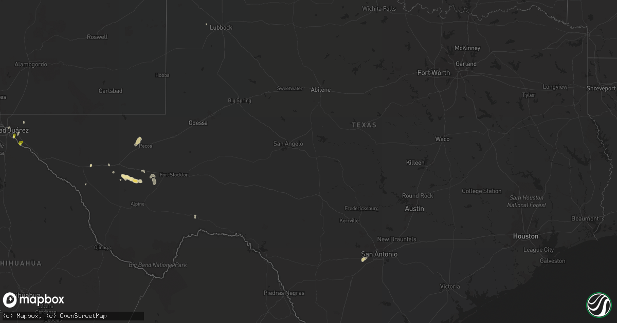
Hail Map in Texas on June 4, 2019
Get this storm
June 4 map
$229
one time, instant access
Download today. No call, no setup
Keep the $229
Bought the map and want the full workflow? Apply the entire $229 to a subscription within 7 days. None of it is wasted.
Every map, not just this one
This buys you this map. Subscription and you get every map we run, in the markets you choose from a few cities to whole states to nationwide. Plus real-time alerts the moment a storm fires.
Contact data
Name, contact info, occupancy, even credit band for addresses in the footprint. You go from where it hit to who to call.
Become the source they trust
Unlimited branding weather history reports on demand. You already have the documented answer ready for the property owner, and you are the one who showed up with it.
Property data and RoofTrace estimates
Pull up any address you have got, its value and the exact code rules for that jurisdiction, straight from One Click Code. Then RoofTrace estimates the squares, pitch, and roof value, priced the way you price.
Storm reports in Texas
Texas
| Date | Description |
|---|---|
| 06/04/20194:25 PM CDT | A local report indicates 63 MPH wind near KELP |
| 06/04/20194:24 PM CDT | A local report indicates 1.00 inch wind near FABENS |
| 06/04/20194:16 PM CDT | A local report indicates 1.00 inch wind near SOCORRO |
| 06/04/20192:00 PM CDT | Thunderstorms with high winds severely damaged three aircraft and two hangars at the castroville municipal airport. Minor damage also occurred at the terminal. Damage w |
| 06/04/20197:13 AM CDT | At 1212 AM CDT, severe thunderstorms were located along a line extending from 4 miles east of Summerfield to 3 miles southwest of Easter to 7 miles northwest of Earth, moving northeast at 30 mph. HAZARD...Ping pong ball size hail. SOURCE...Radar indicated. IMPACT...People and animals outdoors will be injured. Expect damage to roofs, siding, windows, and vehicles. Locations impacted include... Dimmitt, Hart, Easter and Nazareth. |
| 06/04/20194:41 AM CDT | At 941 PM CDT, a severe thunderstorm was located near Rhea, or 16 miles west of Friona, moving north at 20 mph. HAZARD...60 mph wind gusts and half dollar size hail. SOURCE...Radar indicated. IMPACT...Hail damage to vehicles is expected. Expect wind damage to roofs, siding, and trees. Locations impacted include... Rhea. |
| 06/04/20194:00 AM CDT | At 900 PM MDT, a severe thunderstorm was located near Bellview, or 23 miles north of Clovis, and is nearly stationary. HAZARD...60 mph wind gusts and half dollar size hail. SOURCE...Radar indicated. IMPACT...Hail damage to vehicles is expected. Expect wind damage to roofs, siding, and trees. Locations impacted include... Broadview and Bellview. |
| 06/04/20193:51 AM CDT | At 851 PM CDT, a severe thunderstorm was located 10 miles northwest of Pecos, moving northeast at 30 mph. HAZARD...60 mph wind gusts and quarter size hail. SOURCE...Radar indicated. IMPACT...Hail damage to vehicles is expected. Expect wind damage to roofs, siding, and trees. Locations impacted include... Mentone. |
| 06/04/20193:31 AM CDT | At 830 PM MDT, a severe thunderstorm was located near Bellview, or 23 miles west of Friona, moving northeast at 15 mph. HAZARD...60 mph wind gusts and quarter size hail. SOURCE...Radar indicated. IMPACT...Hail damage to vehicles is expected. Expect wind damage to roofs, siding, and trees. Locations impacted include... Bellview. |
| 06/04/20191:40 AM CDT | At 640 PM CDT, a severe thunderstorm was located 8 miles south of Balmorhea State Park, or 17 miles northeast of Fort Davis, moving east at 20 mph. HAZARD...60 mph wind gusts and half dollar size hail. SOURCE...Radar indicated. IMPACT...Hail damage to vehicles is expected. Expect wind damage to roofs, siding, and trees. Locations impacted include... Star Mountain. |
| 06/04/201912:59 AM CDT | At 559 PM CDT, a severe thunderstorm was located 10 miles west of Balmorhea State Park, or 20 miles southeast of Kent, moving northeast at 5 mph. HAZARD...60 mph wind gusts and quarter size hail. SOURCE...Radar indicated. IMPACT...Hail damage to vehicles is expected. Expect wind damage to roofs, siding, and trees. Locations impacted include... Balmorhea, Balmorhea State Park, Buffalo Trail Scout Camp and Toyahvale.This includes Interstate 10 between mile markers 197 and 206. |
| 06/03/201911:10 PM CDT | A local report indicates 58 MPH wind near 2 WNW HEREFORD |
| 06/03/201910:44 PM CDT | At 344 PM MDT, a severe thunderstorm was located over Hueco Tanks, moving north at 35 mph. HAZARD...60 mph wind gusts and quarter size hail. SOURCE...Trained weather spotters reported hail sized up to an inch. IMPACT...Hail damage to vehicles is expected. Expect wind damage to roofs, siding, and trees. Locations impacted include... Loma Linda, Desert Haven, Hueco Tanks, McGregor Range Base, Homestead Meadows, Butterfield, Hueco Mountain Estates, Montana Vista and The Otero Mesa. |
| 06/03/201910:39 PM CDT | At 337 PM MDT, a severe thunderstorm was located in Northeast El Paso, moving north at 35 mph. HAZARD...60 mph wind gusts and quarter size hail. SOURCE...One inch hail and 63 mph wind gusts reported. IMPACT...Hail damage to vehicles is expected. Expect wind damage to roofs, siding, and trees. Locations impacted include... Northeast El Paso, Chaparral, Orogrande, McGregor Range Base, Fort Bliss Northeast, Biggs Field and The Otero Mesa. |
| 06/03/201910:25 PM CDT | At 324 PM MDT, severe thunderstorms were located near Santa Teresa, moving north at 25 mph. HAZARD...70 mph wind gusts and quarter size hail. SOURCE...Radar indicated. IMPACT...Hail damage to vehicles is expected. Expect considerable tree damage. Wind damage is also likely to mobile homes, roofs, and outbuildings. Locations impacted include... West El Paso, Santa Teresa, Anthony, Vado, Sunland Park, Afton, Canutillo, Berino, Westway, Vinton, Mesquite, Chamberino, San Miguel, La Union, La Mesa, Union Pacific Intermodal Terminal, Afton Generating Plant, Mount Riley, Aden Crater and Kilbourne Hole. |
| 06/03/201910:11 PM CDT | At 310 PM MDT, a severe thunderstorm was located just south of Central El Paso, moving north at 25 mph. HAZARD...60 mph wind gusts and quarter size hail. SOURCE...Radar indicated. IMPACT...Hail damage to vehicles is expected. Expect wind damage to roofs, siding, and trees. Locations impacted include... West El Paso, Central El Paso, East El Paso, Northeast El Paso, Far East El Paso, Mission Valley, Clint, Chaparral, Anthony, Sunland Park, San Elizario, Canutillo, Westway, Fort Bliss, Vinton, Socorro, Sparks, Biggs Field, Fort Bliss Northeast and Franklin Mountains State Park. |
| 06/03/20199:57 PM CDT | At 257 PM MDT, a severe thunderstorm was located 4 miles southwest of Tornillo, moving north at 25 mph. HAZARD...60 mph wind gusts and half dollar size hail. SOURCE...Radar indicated. IMPACT...Hail damage to vehicles is expected. Expect wind damage to roofs, siding, and trees. Locations impacted include... Far East El Paso, Tornillo, Clint, Horizon City, Loma Linda, Fabens, Desert Haven, Hueco Tanks, San Elizario, Indian Cliffs Ranch, Socorro, Sparks, Homestead Meadows, Butterfield, Hueco Mountain Estates, Agua Dulce, Dairyland, Lake Way Estates, Montana Vista and Hueco Mountain Wind Ranch. |
All States Impacted by Hail Map on June 4, 2019
Cities Impacted by Hail Map on June 4, 2019
- Frederick, SD
- Bath, SD
- Aberdeen, SD
- Westport, SD
- Ellendale, MN
- Lakefield, MN
- Dumont, IA
- Bristow, IA
- Hardesty, OK
- Lonsdale, MN
- Hemingford, NE
- Fouke, AR
- El Paso, TX
- Littlefork, MN
- Statesboro, GA
- Metter, GA
- Big Falls, MN
- Castroville, TX
- La Coste, TX
- Lewellen, NE
- Arthur, NE
- Atwater, MN
- Kandiyohi, MN
- Silver Lake, MN
- Plato, MN
- Litchfield, MN
- Grove City, MN
- Young America, MN
- New Germany, MN
- Cosmos, MN
- Hutchinson, MN
- Glencoe, MN
- Lester Prairie, MN
- Norwood Young America, MN
- Milford, IA
- Spirit Lake, IA
- Fairfax, SC
- Allendale, SC
- Onida, SD
- Highmore, SD
- Menahga, MN
- La Luz, NM
- Belgrade, MN
- Saint Clair, MN
- Janesville, MN
- Good Thunder, MN
- Mapleton, MN
- Pemberton, MN
- Eagle Lake, MN
- Mankato, MN
- Farwell, MN
- Danube, MN
- Olivia, MN
- Bird Island, MN
- Blomkest, MN
- Lake Lillian, MN
- Renville, MN
- Arco, MN
- Minneota, MN
- Ree Heights, SD
- New Ulm, MN
- Gibbon, MN
- Winthrop, MN
- Lafayette, MN
- Red Wing, MN
- Arlington, MN
- Cromwell, MN
- Kit Carson, CO
- Haswell, CO
- Grey Eagle, MN
- Brumley, MO
- Barrett, MN
- Sylvania, GA
- Eldridge, IA
- Long Grove, IA
- Donahue, IA
- Dexter, MN
- Cloquet, MN
- Sawyer, MN
- Webster, MN
- New Prague, MN
- Jordan, MN
- Le Sueur, MN
- Shakopee, MN
- Lakeville, MN
- Belle Plaine, MN
- Elko New Market, MN
- Cologne, MN
- Carver, MN
- Prior Lake, MN
- Farmington, MN
- Le Center, MN
- Sheffield, IA
- Pelsor, AR
- Dover, AR
- Green Isle, MN
- Salem, MO
- Ludowici, GA
- Beaufort, SC
- Seabrook, SC
- Gary, SD
- Marietta, MN
- Madison, MN
- Clear Lake, SD
- Fort Stockton, TX
- Walnut, IL
- Tampico, IL
- West Concord, MN
- Brooten, MN
- White Oak, GA
- Woodbine, GA
- Sebeka, MN
- Staples, MN
- Hayward, WI
- Springbrook, WI
- Sauk Centre, MN
- Redwood Falls, MN
- Holland, IA
- Grundy Center, IA
- Broadview, NM
- Bovina, TX
- Texico, NM
- Clovis, NM
- Friona, TX
- Saint Helena Island, SC
- Allison, IA
- Fort Davis, TX
- Brownton, MN
- Glenwood, MN
- Long Lake, SD
- Zearing, IA
- Lingle, WY
- Fair Grove, MO
- Orr, MN
- Kabetogama, MN
- International Falls, MN
- Nunn, CO
- Carr, CO
- Lovington, NM
- Moore Haven, FL
- Palmdale, FL
- Fairfax, MN
- Long Pine, NE
- Bassett, NE
- Rochert, MN
- Detroit Lakes, MN
- Rogers, MN
- Hamel, MN
- Maple Grove, MN
- Kenyon, MN
- Reliance, SD
- Lynch, NE
- Wagner, SD
- Fairfax, SD
- Lake Andes, SD
- Sutherland, NE
- North Platte, NE
- Wallace, NE
- Paxton, NE
- Dickens, NE
- Wellfleet, NE
- Elsie, NE
- Puposky, MN
- Marshalltown, IA
- Van Horn, TX
- Karval, CO
- State Center, IA
- Carlton, MN
- Barnum, MN
- Lowry, MN
- Starbuck, MN
- Morris, MN
- Cyrus, MN
- Pottersville, MO
- Caulfield, MO
- West Plains, MO
- New London, MN
- Arkdale, WI
- Fort Laramie, WY
- Owensville, MO
- Lamoure, ND
- Fullerton, ND
- Oakes, ND
- Arnolds Park, IA
- Lorida, FL
- Utica, IL
- Ottawa, IL
- Jesup, GA
- Odum, GA
- Hope, NM
- Mayhill, NM
- Cotton, MN
- Grand Meadow, MN
- Portal, GA
- Waterville, IA
- Harpers Ferry, IA
- Monona, IA
- Eastman, WI
- Nogal, NM
- Ramah, CO
- Cokato, MN
- Dodge Center, MN
- Kasson, MN
- Mantorville, MN
- Byron, MN
- Hampton, IA
- Forgan, OK
- Laverne, OK
- Beaver, OK
- Gate, OK
- Stewart, MN
- Bee Branch, AR
- Rochester, MN
- Stewartville, MN
- Clewiston, FL
- Kingstree, SC
- Felton, MN
- Calhan, CO
- Paris, AR
- Le Claire, IA
- Davenport, IA
- Maynard, MN
- Eldon, MO
- Sunrise Beach, MO
- Kaiser, MO
- Tuscumbia, MO
- Osage Beach, MO
- Lake Ozark, MO
- Blooming Prairie, MN
- Gaylord, MN
- Sleepy Eye, MN
- Cedar Rapids, NE
- Hortense, GA
- Clara City, MN
- Emerson, NE
- Wakefield, NE
- Levelland, TX
- Buffalo, MN
- Monticello, MN
- Harrison, NE
- Lake Crystal, MN
- McCallsburg, IA
- La Junta, CO
- Stratford, TX
- Hereford, TX
- Palatka, FL
- Richland, MO
- Floodwood, MN
- Summit, SD
- Twin Brooks, SD
- South Shore, SD
- Hayfield, MN
- Rush, CO
- Ortley, SD
- Cloudcroft, NM
- Bemidji, MN
- Cass Lake, MN
- Central City, NE
- Hanley Falls, MN
- Montevideo, MN
- Milan, MN
- Granite Falls, MN
- Raymond, MN
- Boyd, MN
- Wood Lake, MN
- Clarkfield, MN
- Watson, MN
- Cottonwood, MN
- Welch, MN
- Goodhue, MN
- Holabird, SD
- Kathryn, ND
- Morgan, MN
- Las Cruces, NM
- Miller, SD
- Harrold, SD
- Kim, CO
- Hugo, MN
- Saint Paul, MN
- Steelville, MO
- Belgrade, MO
- Potosi, MO
- Prophetstown, IL
- Springview, NE
- Stephen, MN
- Browerville, MN
- Hamill, SD
- Gregory, SD
- Elmore, MN
- Erie, IL
- Geneseo, IL
- Motley, MN
- Owatonna, MN
- Oronoco, MN
- Claremont, MN
- Pine Island, MN
- Buffalo Lake, MN
- Linn Creek, MO
- Midland, SD
- Higden, AR
- Clinton, AR
- Choctaw, AR
- Fairfield Bay, AR
- Shirley, AR
- Freeport, MN
- Melrose, MN
- Waynesville, GA
- Waverly, GA
- Bridgeport, NE
- Terril, IA
- Milbank, SD
- Bode, IA
- Soperton, GA
- Tarrytown, GA
- Waubay, SD
- Dickens, IA
- Albion, IA
- Garfield, GA
- Millen, GA
- Laporte, MN
- Mitchell, NE
- Valentine, NE
- Pierre, SD
- Brookston, MN
- Ogallala, NE
- Harmon, IL
- New Bedford, IL
- Deer Grove, IL
- Holland, MN
- Pipestone, MN
- Hernando, MS
- Coldwater, MS
- Okoboji, IA
- Dalhart, TX
- Wheatland, WY
- Lisbon, ND
- Estherville, IA
- Spencer, IA
- Booker, TX
- Ipswich, SD
- Oshkosh, WI
- Mason City, IA
- Rockwell, IA
- New Liberty, IA
- Bettendorf, IA
- Port Byron, IL
- Dixon, IA
- Stockton, IA
- Princeton, IA
- Cordova, IL
- Dawson, MN
- Wabasso, MN
- Canby, MN
- Taunton, MN
- Belview, MN
- Marshall, MN
- Echo, MN
- Vesta, MN
- Brunswick, NE
- Fullerton, NE
- Balko, OK
- Thurston, NE
- Allen, NE
- Wayne, NE
- Georgetown, MN
- Moorhead, MN
- Northome, MN
- Zumbro Falls, MN
- Lake City, MN
- Mazeppa, MN
- Gibbon, NE
- Ravenna, NE
- Osakis, MN
- Prescott, WI
- Amboy, MN
- Vernon Center, MN
- Moody, MO
- Salem, AR
- Viola, AR
- Gepp, AR
- Sturkie, AR
- Bakersfield, MO
- Salters, SC
- Lane, SC
- Squaw Lake, MN
- Max, MN
- Boss, MO
- Bunker, MO
- Sebring, FL
- Spring Valley, MN
- Wykoff, MN
- Preston, MN
- Embarrass, MN
- Round O, SC
- Stockholm, SD
- Brule, NE
- Greene, IA
- Spicer, MN
- Winter, WI
- Tularosa, NM
- Alborn, MN
- Chapman, NE
- Waseca, MN
- La Salle, IL
- Tower, MN
- Las Animas, CO
- Pennock, MN
- Willmar, MN
- Kerkhoven, MN
- Sunburg, MN
- Winthrop, IA
- Iberia, MO
- Boswell, OK
- Cottageville, SC
- Jacksonboro, SC
- Ridgeville, SC
- Green Pond, SC
- Stoutland, MO
- Montreal, MO
- Austin, MN
- Hoople, ND
- Waverly, IA
- Marsland, NE
- Aurora, MO
- Verona, MO
- Moriarty, NM
- Eads, CO
- Revillo, SD
- Strandburg, SD
- Labolt, SD
- Odessa, MN
- Bellingham, MN
- Campbell, MN
- Faulkton, SD
- Seneca, SD
- Bixby, MO
- Norcross, MN
- Jackson, MN
- Radcliffe, IA
- Hugo, CO
- Sauk Rapids, MN
- Sartell, MN
- Mcdonald, NM
- Webster, SD
- Hager City, WI
- Henderson, MN
- Omro, WI
- Winneconne, WI
- Ionia, IA
- Charles City, IA
- Carlsbad, NM
- Shannon, IL
- Tama, IA
- Oshkosh, NE
- Saint Michael, MN
- Pecos, TX
- Balmorhea, TX
- Evansville, MN
- Alexandria, MN
- Hastings, MN
- Cabool, MO
- Willow Springs, MO
- Makinen, MN
- Park Rapids, MN
- Pueblo, CO
- Rye, CO
- Courtland, MN
- Sisseton, SD
- Garner, IA
- Stillwater, MN
- Olive Branch, MS
- Butternut, WI
- Wauzeka, WI
- Altura, MN
- Saint Charles, MN
- Kanawha, IA
- Goodell, IA
- Miltona, MN
- Garfield, MN
- Browns Valley, MN
- Beardsley, MN
- Ortonville, MN
- Corona, SD
- Conrad, IA
- Liscomb, IA
- Belgrade, NE
- Deer River, MN
- Chelsea, IA
- Elberon, IA
- Vining, IA
- Toledo, IA
- Meadowlands, MN
- Saginaw, MN
- Darwin, MN
- Winsted, MN
- Paynesville, MN
- Benson, MN
- Hamburg, MN
- Murdock, MN
- Garden City, KS
- Cubero, NM
- Paguate, NM
- Ashby, MN
- Brandon, MN
- Dalton, MN
- Battle Lake, MN
- River Falls, WI
- Hudson, WI
- Roberts, WI
- Fountain, MN
- Chatfield, MN
- Ava, MO
- Peru, IL
- Mendota, IL
- Troy Grove, IL
- Bard, NM
- San Jon, NM
- Audubon, MN
- Callaway, MN
- Perham, MN
- Ehrhardt, SC
- Islandton, SC
- Warner, SD
- Mansfield, SD
- Bourbonnais, IL
- Colo, IA
- Hanska, MN
- Eustis, NE
- New Hampton, IA
- Valley City, ND
- Winona, MN
- Glenville, MN
- Union, IA
- Grafton, ND
- Calamus, IA
- Elk Creek, MO
- Yukon, MO
- Ayr, ND
- Page, ND
- Albertville, MN
- Elk River, MN
- Lake Park, IA
- Princeton, IL
- Hoffman, MN
- Herman, MN
- Kensington, MN
- Stockholm, WI
- Newington, GA
- Randolph, MN
- Cannon Falls, MN
- Northfield, MN
- Clear Lake, IA
- Ventura, IA
- Concord, NE
- Knoxville, AR
- Frazee, MN
- Vergas, MN
- Prinsburg, MN
- Jonesboro, AR
- Russell, MN
- Glennville, GA
- Eyota, MN
- Osceola, NE
- Leola, AR
- Carthage, AR
- Varnville, SC
- Treynor, IA
- Hampton, MN
- San Elizario, TX
- Graettinger, IA
- Mosquero, NM
- Forbes, ND
- Dorchester, SC
- Circle Pines, MN
- Luana, IA
- Atascosa, TX
- San Antonio, TX
- Natalia, TX
- Devine, TX
- Jal, NM
- Garden City, MN
- Drayton, ND
- Maple Lake, MN
- Arapahoe, CO
- Tornillo, TX
- Fabens, TX
- Babbitt, MN
- Walker, MN
- Akeley, MN
- Clear Lake, MN
- Saint Cloud, MN
- Albert Lea, MN
- Lisco, NE
- Aldrich, MN
- Manly, IA
- Sargeant, MN
- Lanark, IL
- Rhodes, IA
- Melbourne, IA
- Garden City, IA
- Hubbard, IA
- Emmetsburg, IA
- Ayrshire, IA
- Ruthven, IA
- Viburnum, MO
- Cades, SC
- Lower Brule, SD
- Farnam, NE
- Alliance, NE
- Kingsland, GA
- Goodwin, SD
- Elbow Lake, MN
- Hopkinton, IA
- Ashby, NE
- Merriman, NE
- La Moille, IL
- Lemoyne, NE
- Marvin, SD
- Almond, WI
- Lamar, AR
- Grady, NM
- Palisade, MN
- Waconia, MN
- Zumbrota, MN
- Lynd, MN
- Ellsworth, WI
- Bay City, WI
- Saint James, MN
- Ryan, IA
- Manchester, IA
- Avondale, CO
- Saint Anthony, IA
- Clemons, IA
- Fort Stewart, GA
- Foley, MN
- Wanamingo, MN
- Naytahwaush, MN
- Waltham, MN
- Lake George, MN
- Northwood, IA
- Kensett, IA
- Morton, MN
- Tenstrike, MN
- Hines, MN
- Valentine, TX
- Hillsdale, IL
- Shelton, NE
- Sedan, NM
- Texline, TX
- De Valls Bluff, AR
- Hazen, AR
- Mescalero, NM
- Orangeburg, SC
- Bagley, MN
- Mahnomen, MN
- Hay Springs, NE
- Polo, IL
- Mount Morris, IL
- Ulman, MO
- Pine River, WI
- Fremont, WI
- Cavalier, ND
- Crocker, MO
- Dryden, TX
- Alamogordo, NM
- Argusville, ND
- Hollywood, SC
- Adams Run, SC
- Albany, MN
- Loman, MN
- Bangor, WI
- Dodge City, KS
- Hayward, MN
- Klemme, IA
- Crane Lake, MN
- Saint Libory, NE
- Clarks, NE
- Rueter, MO
- Cedarcreek, MO
- Bradleyville, MO
- Kissee Mills, MO
- Mountainair, NM
- Woodstock, MN
- Nashua, IA
- Mountain Grove, MO
- Clint, TX
- Ohio, IL
- Sacred Heart, MN
- Ivanhoe, MN
- Poplar Bluff, MO
- Sardis, GA
- Redby, MN
- Worthington, MN
- Nevis, MN
- West Union, MN
- Long Prairie, MN
- Shelby, NE
- Malden, IL
- Balaton, MN
- Clarks Grove, MN
- Stromsburg, NE
- Elkton, MN
- Hanover, IL
- Burnsville, MN
- Savage, MN
- Alva, FL
- Keystone, NE
- Sabula, IA
- Genoa, NE
- Ault, CO
- Waupaca, WI
- Fenton, IA
- Lone Rock, IA
- Cylinder, IA
- Ringsted, IA
- Talmoon, MN
- Carlos, MN
- Leola, SD
- Racine, MN
- Brownsdale, MN
- Shevlin, MN
- Adrian, TX
- Pleasanton, NE
- Camdenton, MO
- Olar, SC
- Minneapolis, MN
- Swea City, IA
- Mount Vernon, MO
- Marionville, MO
- Medford, MN
- Linn, MO
- Loose Creek, MO
- Hollandale, MN
- Scott City, KS
- Masterson, TX
- Nashua, MN
- Dougherty, IA
- Kelliher, MN
- Lebanon, MO
- Manhattan, IL
- Claxton, GA
- Williamsville, MO
- Wappapello, MO
- Nome, ND
- Rising City, NE
- Bristol, SD
- Cohasset, MN
- Carpenter, IA
- Saint Ansgar, IA
- Loup City, NE
- Ashley, ND
- Oriska, ND
- Wilmington, IL
- Frontenac, MN
- Appleton, MN
- Avon Park, FL
- Chaska, MN
- Eden Valley, MN
- Tyler, MN
- Rosemount, MN
- Curlew, IA
- Dassel, MN
- Nicollet, MN
- Dover, IL
- Marseilles, IL
- Arlington, IL
- Wyanet, IL
- Wedron, IL
- Serena, IL
- Hooppole, IL
- Sheridan, IL
- Cherry, IL
- Sheffield, IL
- Earlville, IL
- Manlius, IL
- Annawan, IL
- Spring Valley, IL
- Twin City, GA
- Bristow, NE
- Springfield, MO
- Leslie, MO
- Villa Ridge, MO
- Bland, MO
- Beaufort, MO
- Union, MO
- Rosebud, MO
- Washington, MO
- Gerald, MO
- Mineral Point, MO
- Cadet, MO
- Bonne Terre, MO
- Hector, MN
- Mayer, MN
- New Auburn, MN
- Caledonia, MN
- Dundas, MN
- Dennison, MN
- Lanesboro, MN
- Faribault, MN
- Montgomery, MN
- Vermillion, MN
- Utica, MN
- Dover, MN
- Rushford, MN
- Kilkenny, MN
- Kellogg, MN
- Stoddard, WI
- Rollingstone, MN
- Hokah, MN
- Mabel, MN
- De Soto, WI
- La Crescent, MN
- Nerstrand, MN
- Minnesota City, MN
- Eitzen, MN
- Elgin, MN
- Dakota, MN
- Plainview, MN
- Wabasha, MN
- Houston, MN
- Spring Grove, MN
- Genoa, WI
- Millville, MN
- Brownsville, MN
- Peterson, MN
- Lewiston, MN
- Saint Peter, MN


