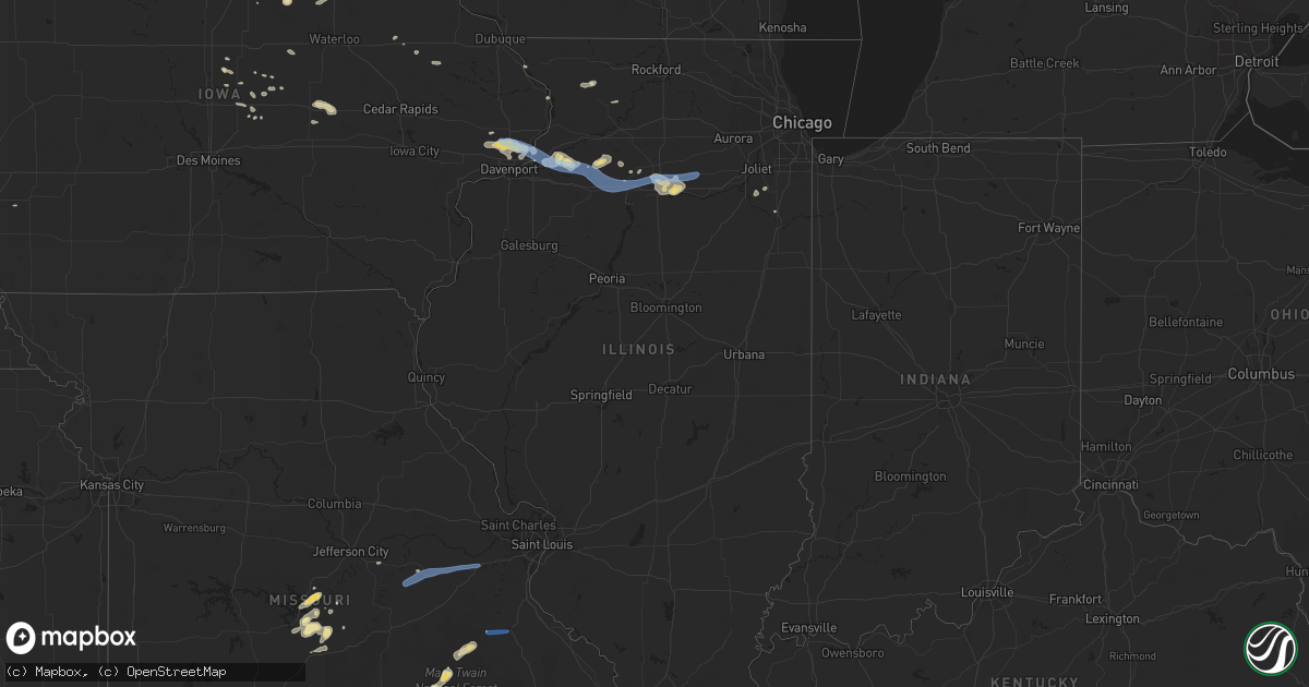
Hail Map in Illinois on June 4, 2019
Get this storm
June 4 map
$229
one time, instant access
Download today. No call, no setup
Keep the $229
Bought the map and want the full workflow? Apply the entire $229 to a subscription within 7 days. None of it is wasted.
Every map, not just this one
This buys you this map. Subscription and you get every map we run, in the markets you choose from a few cities to whole states to nationwide. Plus real-time alerts the moment a storm fires.
Contact data
Name, contact info, occupancy, even credit band for addresses in the footprint. You go from where it hit to who to call.
Become the source they trust
Unlimited branding weather history reports on demand. You already have the documented answer ready for the property owner, and you are the one who showed up with it.
Property data and RoofTrace estimates
Pull up any address you have got, its value and the exact code rules for that jurisdiction, straight from One Click Code. Then RoofTrace estimates the squares, pitch, and roof value, priced the way you price.
Storm reports in Illinois
Illinois
| Date | Description |
|---|---|
| 06/04/201911:38 AM CDT | Tree down blocking highway 26. |
| 06/04/201911:08 AM CDT | Viewer reports powerlines down along highway 78. |
| 06/04/20196:24 AM CDT | At 1122 PM CDT, severe thunderstorms were located along a line extending from Tampico to 7 miles southwest of Walnut to Sheffield, moving east at 40 mph. HAZARD...70 mph wind gusts. SOURCE...Radar indicated. IMPACT...Expect considerable tree damage. Damage is likely to mobile homes, roofs, and outbuildings. Locations impacted include... Princeton, Hennepin, Spring Valley, DePue, Granville, Walnut, Ladd, Wyanet, Sheffield, Tiskilwa, Tampico, La Moille, Dalzell, Buda, Bureau Junction, Deer Grove, Mark, Ohio, Cherry and Neponset.This includes the following highways... Interstate 80 in Illinois between mile markers 37 and 72. Interstate 180 between mile markers 1 and 13. |
| 06/04/20196:18 AM CDT | At 1117 PM CDT, a severe thunderstorm was located over Walnut, or 11 miles southwest of Walton, moving east at 20 mph. HAZARD...60 mph wind gusts and penny size hail. SOURCE...Radar indicated. IMPACT...Expect damage to roofs, siding, and trees. This severe thunderstorm will remain over mainly rural areas of southwestern Lee County. |
| 06/04/201912:20 AM CDT | Roof blown off of troy grove township building... Vermillion street. Also power lines down. |
| 06/04/201912:11 AM CDT | Delayed report. Roof damage to a home and powerlines down across a roadway in the area where the damage occurred. Report from illinois valley 911 dispatch relayed by br |
| 06/03/201911:52 PM CDT | Tree down on powerlines causing them to arc. |
| 06/03/201911:38 PM CDT | Corrects previous tstm wnd dmg report from 3 n princeton. Tree down blocking highway 26. |
| 06/03/201911:26 PM CDT | Large tree down blocking highway 40. |
| 06/03/201911:08 PM CDT | Widespread tree damage with many uprooted trees in approx 5 mi radius around town. Agriculture system 1 mi west of town damaged. Delayed report. |
| 06/03/201911:08 PM CDT | Corrects previous tstm wnd dmg report from hooppole. Viewer reports powerlines down along highway 78. |
| 06/03/201911:06 PM CDT | Lots of tree damage near hwy 92 and e 220th st. Several cottonwood trees damaged. |
| 06/03/201910:58 PM CDT | Several large trees down. |
| 06/03/201910:34 PM CDT | 18-24 inch diameter tree down onto another tree. |
| 06/03/201910:32 PM CDT | Large tree uprooted. Time estimated by radar. |
| 06/03/201910:26 PM CDT | Tree down across railroad tracks. |
All States Impacted by Hail Map on June 4, 2019
Cities Impacted by Hail Map on June 4, 2019
- Frederick, SD
- Bath, SD
- Aberdeen, SD
- Westport, SD
- Ellendale, MN
- Lakefield, MN
- Dumont, IA
- Bristow, IA
- Hardesty, OK
- Lonsdale, MN
- Hemingford, NE
- Fouke, AR
- El Paso, TX
- Littlefork, MN
- Statesboro, GA
- Metter, GA
- Big Falls, MN
- Castroville, TX
- La Coste, TX
- Lewellen, NE
- Arthur, NE
- Atwater, MN
- Kandiyohi, MN
- Silver Lake, MN
- Plato, MN
- Litchfield, MN
- Grove City, MN
- Young America, MN
- New Germany, MN
- Cosmos, MN
- Hutchinson, MN
- Glencoe, MN
- Lester Prairie, MN
- Norwood Young America, MN
- Milford, IA
- Spirit Lake, IA
- Fairfax, SC
- Allendale, SC
- Onida, SD
- Highmore, SD
- Menahga, MN
- La Luz, NM
- Belgrade, MN
- Saint Clair, MN
- Janesville, MN
- Good Thunder, MN
- Mapleton, MN
- Pemberton, MN
- Eagle Lake, MN
- Mankato, MN
- Farwell, MN
- Danube, MN
- Olivia, MN
- Bird Island, MN
- Blomkest, MN
- Lake Lillian, MN
- Renville, MN
- Arco, MN
- Minneota, MN
- Ree Heights, SD
- New Ulm, MN
- Gibbon, MN
- Winthrop, MN
- Lafayette, MN
- Red Wing, MN
- Arlington, MN
- Cromwell, MN
- Kit Carson, CO
- Haswell, CO
- Grey Eagle, MN
- Brumley, MO
- Barrett, MN
- Sylvania, GA
- Eldridge, IA
- Long Grove, IA
- Donahue, IA
- Dexter, MN
- Cloquet, MN
- Sawyer, MN
- Webster, MN
- New Prague, MN
- Jordan, MN
- Le Sueur, MN
- Shakopee, MN
- Lakeville, MN
- Belle Plaine, MN
- Elko New Market, MN
- Cologne, MN
- Carver, MN
- Prior Lake, MN
- Farmington, MN
- Le Center, MN
- Sheffield, IA
- Pelsor, AR
- Dover, AR
- Green Isle, MN
- Salem, MO
- Ludowici, GA
- Beaufort, SC
- Seabrook, SC
- Gary, SD
- Marietta, MN
- Madison, MN
- Clear Lake, SD
- Fort Stockton, TX
- Walnut, IL
- Tampico, IL
- West Concord, MN
- Brooten, MN
- White Oak, GA
- Woodbine, GA
- Sebeka, MN
- Staples, MN
- Hayward, WI
- Springbrook, WI
- Sauk Centre, MN
- Redwood Falls, MN
- Holland, IA
- Grundy Center, IA
- Broadview, NM
- Bovina, TX
- Texico, NM
- Clovis, NM
- Friona, TX
- Saint Helena Island, SC
- Allison, IA
- Fort Davis, TX
- Brownton, MN
- Glenwood, MN
- Long Lake, SD
- Zearing, IA
- Lingle, WY
- Fair Grove, MO
- Orr, MN
- Kabetogama, MN
- International Falls, MN
- Nunn, CO
- Carr, CO
- Lovington, NM
- Moore Haven, FL
- Palmdale, FL
- Fairfax, MN
- Long Pine, NE
- Bassett, NE
- Rochert, MN
- Detroit Lakes, MN
- Rogers, MN
- Hamel, MN
- Maple Grove, MN
- Kenyon, MN
- Reliance, SD
- Lynch, NE
- Wagner, SD
- Fairfax, SD
- Lake Andes, SD
- Sutherland, NE
- North Platte, NE
- Wallace, NE
- Paxton, NE
- Dickens, NE
- Wellfleet, NE
- Elsie, NE
- Puposky, MN
- Marshalltown, IA
- Van Horn, TX
- Karval, CO
- State Center, IA
- Carlton, MN
- Barnum, MN
- Lowry, MN
- Starbuck, MN
- Morris, MN
- Cyrus, MN
- Pottersville, MO
- Caulfield, MO
- West Plains, MO
- New London, MN
- Arkdale, WI
- Fort Laramie, WY
- Owensville, MO
- Lamoure, ND
- Fullerton, ND
- Oakes, ND
- Arnolds Park, IA
- Lorida, FL
- Utica, IL
- Ottawa, IL
- Jesup, GA
- Odum, GA
- Hope, NM
- Mayhill, NM
- Cotton, MN
- Grand Meadow, MN
- Portal, GA
- Waterville, IA
- Harpers Ferry, IA
- Monona, IA
- Eastman, WI
- Nogal, NM
- Ramah, CO
- Cokato, MN
- Dodge Center, MN
- Kasson, MN
- Mantorville, MN
- Byron, MN
- Hampton, IA
- Forgan, OK
- Laverne, OK
- Beaver, OK
- Gate, OK
- Stewart, MN
- Bee Branch, AR
- Rochester, MN
- Stewartville, MN
- Clewiston, FL
- Kingstree, SC
- Felton, MN
- Calhan, CO
- Paris, AR
- Le Claire, IA
- Davenport, IA
- Maynard, MN
- Eldon, MO
- Sunrise Beach, MO
- Kaiser, MO
- Tuscumbia, MO
- Osage Beach, MO
- Lake Ozark, MO
- Blooming Prairie, MN
- Gaylord, MN
- Sleepy Eye, MN
- Cedar Rapids, NE
- Hortense, GA
- Clara City, MN
- Emerson, NE
- Wakefield, NE
- Levelland, TX
- Buffalo, MN
- Monticello, MN
- Harrison, NE
- Lake Crystal, MN
- McCallsburg, IA
- La Junta, CO
- Stratford, TX
- Hereford, TX
- Palatka, FL
- Richland, MO
- Floodwood, MN
- Summit, SD
- Twin Brooks, SD
- South Shore, SD
- Hayfield, MN
- Rush, CO
- Ortley, SD
- Cloudcroft, NM
- Bemidji, MN
- Cass Lake, MN
- Central City, NE
- Hanley Falls, MN
- Montevideo, MN
- Milan, MN
- Granite Falls, MN
- Raymond, MN
- Boyd, MN
- Wood Lake, MN
- Clarkfield, MN
- Watson, MN
- Cottonwood, MN
- Welch, MN
- Goodhue, MN
- Holabird, SD
- Kathryn, ND
- Morgan, MN
- Las Cruces, NM
- Miller, SD
- Harrold, SD
- Kim, CO
- Hugo, MN
- Saint Paul, MN
- Steelville, MO
- Belgrade, MO
- Potosi, MO
- Prophetstown, IL
- Springview, NE
- Stephen, MN
- Browerville, MN
- Hamill, SD
- Gregory, SD
- Elmore, MN
- Erie, IL
- Geneseo, IL
- Motley, MN
- Owatonna, MN
- Oronoco, MN
- Claremont, MN
- Pine Island, MN
- Buffalo Lake, MN
- Linn Creek, MO
- Midland, SD
- Higden, AR
- Clinton, AR
- Choctaw, AR
- Fairfield Bay, AR
- Shirley, AR
- Freeport, MN
- Melrose, MN
- Waynesville, GA
- Waverly, GA
- Bridgeport, NE
- Terril, IA
- Milbank, SD
- Bode, IA
- Soperton, GA
- Tarrytown, GA
- Waubay, SD
- Dickens, IA
- Albion, IA
- Garfield, GA
- Millen, GA
- Laporte, MN
- Mitchell, NE
- Valentine, NE
- Pierre, SD
- Brookston, MN
- Ogallala, NE
- Harmon, IL
- New Bedford, IL
- Deer Grove, IL
- Holland, MN
- Pipestone, MN
- Hernando, MS
- Coldwater, MS
- Okoboji, IA
- Dalhart, TX
- Wheatland, WY
- Lisbon, ND
- Estherville, IA
- Spencer, IA
- Booker, TX
- Ipswich, SD
- Oshkosh, WI
- Mason City, IA
- Rockwell, IA
- New Liberty, IA
- Bettendorf, IA
- Port Byron, IL
- Dixon, IA
- Stockton, IA
- Princeton, IA
- Cordova, IL
- Dawson, MN
- Wabasso, MN
- Canby, MN
- Taunton, MN
- Belview, MN
- Marshall, MN
- Echo, MN
- Vesta, MN
- Brunswick, NE
- Fullerton, NE
- Balko, OK
- Thurston, NE
- Allen, NE
- Wayne, NE
- Georgetown, MN
- Moorhead, MN
- Northome, MN
- Zumbro Falls, MN
- Lake City, MN
- Mazeppa, MN
- Gibbon, NE
- Ravenna, NE
- Osakis, MN
- Prescott, WI
- Amboy, MN
- Vernon Center, MN
- Moody, MO
- Salem, AR
- Viola, AR
- Gepp, AR
- Sturkie, AR
- Bakersfield, MO
- Salters, SC
- Lane, SC
- Squaw Lake, MN
- Max, MN
- Boss, MO
- Bunker, MO
- Sebring, FL
- Spring Valley, MN
- Wykoff, MN
- Preston, MN
- Embarrass, MN
- Round O, SC
- Stockholm, SD
- Brule, NE
- Greene, IA
- Spicer, MN
- Winter, WI
- Tularosa, NM
- Alborn, MN
- Chapman, NE
- Waseca, MN
- La Salle, IL
- Tower, MN
- Las Animas, CO
- Pennock, MN
- Willmar, MN
- Kerkhoven, MN
- Sunburg, MN
- Winthrop, IA
- Iberia, MO
- Boswell, OK
- Cottageville, SC
- Jacksonboro, SC
- Ridgeville, SC
- Green Pond, SC
- Stoutland, MO
- Montreal, MO
- Austin, MN
- Hoople, ND
- Waverly, IA
- Marsland, NE
- Aurora, MO
- Verona, MO
- Moriarty, NM
- Eads, CO
- Revillo, SD
- Strandburg, SD
- Labolt, SD
- Odessa, MN
- Bellingham, MN
- Campbell, MN
- Faulkton, SD
- Seneca, SD
- Bixby, MO
- Norcross, MN
- Jackson, MN
- Radcliffe, IA
- Hugo, CO
- Sauk Rapids, MN
- Sartell, MN
- Mcdonald, NM
- Webster, SD
- Hager City, WI
- Henderson, MN
- Omro, WI
- Winneconne, WI
- Ionia, IA
- Charles City, IA
- Carlsbad, NM
- Shannon, IL
- Tama, IA
- Oshkosh, NE
- Saint Michael, MN
- Pecos, TX
- Balmorhea, TX
- Evansville, MN
- Alexandria, MN
- Hastings, MN
- Cabool, MO
- Willow Springs, MO
- Makinen, MN
- Park Rapids, MN
- Pueblo, CO
- Rye, CO
- Courtland, MN
- Sisseton, SD
- Garner, IA
- Stillwater, MN
- Olive Branch, MS
- Butternut, WI
- Wauzeka, WI
- Altura, MN
- Saint Charles, MN
- Kanawha, IA
- Goodell, IA
- Miltona, MN
- Garfield, MN
- Browns Valley, MN
- Beardsley, MN
- Ortonville, MN
- Corona, SD
- Conrad, IA
- Liscomb, IA
- Belgrade, NE
- Deer River, MN
- Chelsea, IA
- Elberon, IA
- Vining, IA
- Toledo, IA
- Meadowlands, MN
- Saginaw, MN
- Darwin, MN
- Winsted, MN
- Paynesville, MN
- Benson, MN
- Hamburg, MN
- Murdock, MN
- Garden City, KS
- Cubero, NM
- Paguate, NM
- Ashby, MN
- Brandon, MN
- Dalton, MN
- Battle Lake, MN
- River Falls, WI
- Hudson, WI
- Roberts, WI
- Fountain, MN
- Chatfield, MN
- Ava, MO
- Peru, IL
- Mendota, IL
- Troy Grove, IL
- Bard, NM
- San Jon, NM
- Audubon, MN
- Callaway, MN
- Perham, MN
- Ehrhardt, SC
- Islandton, SC
- Warner, SD
- Mansfield, SD
- Bourbonnais, IL
- Colo, IA
- Hanska, MN
- Eustis, NE
- New Hampton, IA
- Valley City, ND
- Winona, MN
- Glenville, MN
- Union, IA
- Grafton, ND
- Calamus, IA
- Elk Creek, MO
- Yukon, MO
- Ayr, ND
- Page, ND
- Albertville, MN
- Elk River, MN
- Lake Park, IA
- Princeton, IL
- Hoffman, MN
- Herman, MN
- Kensington, MN
- Stockholm, WI
- Newington, GA
- Randolph, MN
- Cannon Falls, MN
- Northfield, MN
- Clear Lake, IA
- Ventura, IA
- Concord, NE
- Knoxville, AR
- Frazee, MN
- Vergas, MN
- Prinsburg, MN
- Jonesboro, AR
- Russell, MN
- Glennville, GA
- Eyota, MN
- Osceola, NE
- Leola, AR
- Carthage, AR
- Varnville, SC
- Treynor, IA
- Hampton, MN
- San Elizario, TX
- Graettinger, IA
- Mosquero, NM
- Forbes, ND
- Dorchester, SC
- Circle Pines, MN
- Luana, IA
- Atascosa, TX
- San Antonio, TX
- Natalia, TX
- Devine, TX
- Jal, NM
- Garden City, MN
- Drayton, ND
- Maple Lake, MN
- Arapahoe, CO
- Tornillo, TX
- Fabens, TX
- Babbitt, MN
- Walker, MN
- Akeley, MN
- Clear Lake, MN
- Saint Cloud, MN
- Albert Lea, MN
- Lisco, NE
- Aldrich, MN
- Manly, IA
- Sargeant, MN
- Lanark, IL
- Rhodes, IA
- Melbourne, IA
- Garden City, IA
- Hubbard, IA
- Emmetsburg, IA
- Ayrshire, IA
- Ruthven, IA
- Viburnum, MO
- Cades, SC
- Lower Brule, SD
- Farnam, NE
- Alliance, NE
- Kingsland, GA
- Goodwin, SD
- Elbow Lake, MN
- Hopkinton, IA
- Ashby, NE
- Merriman, NE
- La Moille, IL
- Lemoyne, NE
- Marvin, SD
- Almond, WI
- Lamar, AR
- Grady, NM
- Palisade, MN
- Waconia, MN
- Zumbrota, MN
- Lynd, MN
- Ellsworth, WI
- Bay City, WI
- Saint James, MN
- Ryan, IA
- Manchester, IA
- Avondale, CO
- Saint Anthony, IA
- Clemons, IA
- Fort Stewart, GA
- Foley, MN
- Wanamingo, MN
- Naytahwaush, MN
- Waltham, MN
- Lake George, MN
- Northwood, IA
- Kensett, IA
- Morton, MN
- Tenstrike, MN
- Hines, MN
- Valentine, TX
- Hillsdale, IL
- Shelton, NE
- Sedan, NM
- Texline, TX
- De Valls Bluff, AR
- Hazen, AR
- Mescalero, NM
- Orangeburg, SC
- Bagley, MN
- Mahnomen, MN
- Hay Springs, NE
- Polo, IL
- Mount Morris, IL
- Ulman, MO
- Pine River, WI
- Fremont, WI
- Cavalier, ND
- Crocker, MO
- Dryden, TX
- Alamogordo, NM
- Argusville, ND
- Hollywood, SC
- Adams Run, SC
- Albany, MN
- Loman, MN
- Bangor, WI
- Dodge City, KS
- Hayward, MN
- Klemme, IA
- Crane Lake, MN
- Saint Libory, NE
- Clarks, NE
- Rueter, MO
- Cedarcreek, MO
- Bradleyville, MO
- Kissee Mills, MO
- Mountainair, NM
- Woodstock, MN
- Nashua, IA
- Mountain Grove, MO
- Clint, TX
- Ohio, IL
- Sacred Heart, MN
- Ivanhoe, MN
- Poplar Bluff, MO
- Sardis, GA
- Redby, MN
- Worthington, MN
- Nevis, MN
- West Union, MN
- Long Prairie, MN
- Shelby, NE
- Malden, IL
- Balaton, MN
- Clarks Grove, MN
- Stromsburg, NE
- Elkton, MN
- Hanover, IL
- Burnsville, MN
- Savage, MN
- Alva, FL
- Keystone, NE
- Sabula, IA
- Genoa, NE
- Ault, CO
- Waupaca, WI
- Fenton, IA
- Lone Rock, IA
- Cylinder, IA
- Ringsted, IA
- Talmoon, MN
- Carlos, MN
- Leola, SD
- Racine, MN
- Brownsdale, MN
- Shevlin, MN
- Adrian, TX
- Pleasanton, NE
- Camdenton, MO
- Olar, SC
- Minneapolis, MN
- Swea City, IA
- Mount Vernon, MO
- Marionville, MO
- Medford, MN
- Linn, MO
- Loose Creek, MO
- Hollandale, MN
- Scott City, KS
- Masterson, TX
- Nashua, MN
- Dougherty, IA
- Kelliher, MN
- Lebanon, MO
- Manhattan, IL
- Claxton, GA
- Williamsville, MO
- Wappapello, MO
- Nome, ND
- Rising City, NE
- Bristol, SD
- Cohasset, MN
- Carpenter, IA
- Saint Ansgar, IA
- Loup City, NE
- Ashley, ND
- Oriska, ND
- Wilmington, IL
- Frontenac, MN
- Appleton, MN
- Avon Park, FL
- Chaska, MN
- Eden Valley, MN
- Tyler, MN
- Rosemount, MN
- Curlew, IA
- Dassel, MN
- Nicollet, MN
- Dover, IL
- Marseilles, IL
- Arlington, IL
- Wyanet, IL
- Wedron, IL
- Serena, IL
- Hooppole, IL
- Sheridan, IL
- Cherry, IL
- Sheffield, IL
- Earlville, IL
- Manlius, IL
- Annawan, IL
- Spring Valley, IL
- Twin City, GA
- Bristow, NE
- Springfield, MO
- Leslie, MO
- Villa Ridge, MO
- Bland, MO
- Beaufort, MO
- Union, MO
- Rosebud, MO
- Washington, MO
- Gerald, MO
- Mineral Point, MO
- Cadet, MO
- Bonne Terre, MO
- Hector, MN
- Mayer, MN
- New Auburn, MN
- Caledonia, MN
- Dundas, MN
- Dennison, MN
- Lanesboro, MN
- Faribault, MN
- Montgomery, MN
- Vermillion, MN
- Utica, MN
- Dover, MN
- Rushford, MN
- Kilkenny, MN
- Kellogg, MN
- Stoddard, WI
- Rollingstone, MN
- Hokah, MN
- Mabel, MN
- De Soto, WI
- La Crescent, MN
- Nerstrand, MN
- Minnesota City, MN
- Eitzen, MN
- Elgin, MN
- Dakota, MN
- Plainview, MN
- Wabasha, MN
- Houston, MN
- Spring Grove, MN
- Genoa, WI
- Millville, MN
- Brownsville, MN
- Peterson, MN
- Lewiston, MN
- Saint Peter, MN


