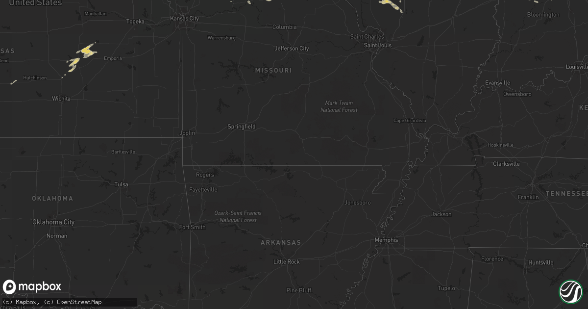
Hail Map in Iowa on June 4, 2011
Get this storm
June 4 map
$229
one time, instant access
Download today. No call, no setup
Keep the $229
Bought the map and want the full workflow? Apply the entire $229 to a subscription within 7 days. None of it is wasted.
Every map, not just this one
This buys you this map. Subscription and you get every map we run, in the markets you choose from a few cities to whole states to nationwide. Plus real-time alerts the moment a storm fires.
Contact data
Name, contact info, occupancy, even credit band for addresses in the footprint. You go from where it hit to who to call.
Become the source they trust
Unlimited branding weather history reports on demand. You already have the documented answer ready for the property owner, and you are the one who showed up with it.
Property data and RoofTrace estimates
Pull up any address you have got, its value and the exact code rules for that jurisdiction, straight from One Click Code. Then RoofTrace estimates the squares, pitch, and roof value, priced the way you price.
Storm reports in Iowa
Iowa
| Date | Description |
|---|---|
| 06/04/20115:40 PM CDT | Nickel to quarter size. Winds 30 to 40 mph. |
| 06/04/20113:44 PM CDT | From iowa state patrol. |
| 06/04/20113:35 PM CDT | Quarter sized hail and 45 mph. Hail covering ground. |
| 06/04/20116:28 AM CDT | On the west side of west burlington near the intersection of gear and agency avenue. |
| 06/04/20116:15 AM CDT | Relayed from poweshiek county dispatch |
| 06/04/20116:15 AM CDT | Relayed from wfo dvn |
| 06/04/20114:45 AM CDT | A local report indicates 2.00 inch wind near BEACON |
| 06/04/20114:45 AM CDT | Relayed from who tv |
| 06/04/20114:44 AM CDT | A local report indicates 1.75 inch wind near BEACON |
| 06/04/20114:41 AM CDT | A local report indicates 1.00 inch wind near BEACON |
All States Impacted by Hail Map on June 4, 2011
Cities Impacted by Hail Map on June 4, 2011
- Oskaloosa, IA
- New Sharon, IA
- Murrysville, PA
- Export, PA
- Irwin, PA
- Monroeville, PA
- Trafford, PA
- West Terre Haute, IN
- Washington, LA
- Ville Platte, LA
- Liberty Center, IN
- Markle, IN
- Bluffton, IN
- Chillicothe, OH
- Keithville, LA
- Oswego, IL
- Plainfield, IL
- Hedrick, IA
- Ollie, IA
- Batavia, IA
- Packwood, IA
- Fairfield, IA
- Grenville, NM
- Maroa, IL
- South English, IA
- Titusville, PA
- Guys Mills, PA
- Kalona, IA
- Linn, WV
- Salisbury, MO
- Middletown, IL
- Athens, IL
- Elkhart, IL
- Greenview, IL
- Kentland, IN
- Sheldon, IL
- Glenwood, IL
- Saint John, IN
- Crown Point, IN
- Lansing, IL
- Grant Park, IL
- Thornton, IL
- Beecher, IL
- Dyer, IN
- Lowell, IN
- Hebron, IN
- Crete, IL
- Chicago Heights, IL
- Cedar Lake, IN
- Van Buren, IN
- Warren, IN
- Brook, IN
- Rensselaer, IN
- Watseka, IL
- Morocco, IN
- Donovan, IL
- Earl Park, IN
- New Philadelphia, OH
- Dover, OH
- Cantril, IA
- Milton, IA
- Keosauqua, IA
- Iowa, LA
- Richwood, WV
- Craigsville, WV
- Basco, IL
- Carthage, IL
- Mills, NM
- Brighton, IA
- Harleton, TX
- Marshall, TX
- Jefferson, TX
- Monroeville, OH
- Willard, OH
- North Fairfield, OH
- Fairmount, IL
- Westville, IL
- Catlin, IL
- Danville, IL
- Indianola, IL
- Massillon, OH
- Louisville, OH
- Canton, OH
- North Canton, OH
- East Canton, OH
- East Sparta, OH
- Montrose, IA
- Wapello, IA
- Letts, IA
- Columbus Junction, IA
- Grandview, IA
- Muscatine, IA
- New Boston, IL
- Joy, IL
- McDonald, PA
- Cooperstown, PA
- Franklin, PA
- Perry, FL
- Greenville, FL
- Huntington, IN
- Andrews, IN
- Plain City, OH
- Cloudcroft, NM
- Big Sandy, TX
- Gilmer, TX
- Franklin, OH
- Newton, GA
- Leary, GA
- Talco, TX
- Sulphur Bluff, TX
- Mount Vernon, TX
- Opelousas, LA
- Montpelier, IN
- Pennville, IN
- Keystone, IN
- Eglin Afb, FL
- Waterford, PA
- Edinboro, PA
- Cambridge Springs, PA
- McKean, PA
- Minford, OH
- Amlin, OH
- Oak Hill, OH
- West Jefferson, OH
- Beaver, OH
- Grove City, OH
- Clarksburg, OH
- Thurman, OH
- Galloway, OH
- Groveport, OH
- Frankfort, OH
- Amanda, OH
- Harrisburg, OH
- Kingston, OH
- New Holland, OH
- Wilkesville, OH
- Lockbourne, OH
- Hilliard, OH
- Coalton, OH
- Greenfield, OH
- Pataskala, OH
- Pedro, OH
- Lucasville, OH
- Stoutsville, OH
- Circleville, OH
- Tarlton, OH
- McArthur, OH
- Lancaster, OH
- Dublin, OH
- Wheelersburg, OH
- Carroll, OH
- Williamsport, OH
- Hamden, OH
- Ashville, OH
- Commercial Point, OH
- London, OH
- Bidwell, OH
- Jackson, OH
- Portsmouth, OH
- Powell, OH
- Canal Winchester, OH
- Logan, OH
- South Vienna, OH
- South Bloomingville, OH
- Pickerington, OH
- South Webster, OH
- Orient, OH
- Franklin Furnace, OH
- Washington Court House, OH
- Laurelville, OH
- Waverly, OH
- Rockbridge, OH
- Ray, OH
- Reynoldsburg, OH
- Vinton, OH
- New Plymouth, OH
- Creola, OH
- Millersport, OH
- Piketon, OH
- Columbus, OH
- Baltimore, OH
- Mount Sterling, OH
- Wellston, OH
- Blacklick, OH
- Mount Pleasant, TX
- Colchester, IL
- Ambia, IN
- Wellington, IL
- Oxford, IN
- Boswell, IN
- Milford, IL
- Hoopeston, IL
- Fowler, IN
- Mount Pleasant, IA
- Ronceverte, WV
- Sinks Grove, WV
- Karnack, TX
- Golden, IL
- Littleton, IL
- Augusta, IL
- Plymouth, IL
- Huntsville, IL
- Camden, IL
- Rushville, IL
- La Prairie, IL
- Bowen, IL
- Goodfield, IL
- Carlock, IL
- Deer Creek, IL
- Secor, IL
- Congerville, IL
- Oakwood, IL
- Georgetown, IL
- Sidell, IL
- Ridge Farm, IL
- Tilton, IL
- Strong City, KS
- McDermott, OH
- Lagro, IN
- Lewisburg, WV
- Caldwell, WV
- White Sulphur Springs, WV
- Frankford, WV
- Maxwelton, WV
- Murrayville, IL
- West Milton, OH
- Laura, OH
- Englewood, OH
- Coatsburg, IL
- Mendon, IL
- Logansport, LA
- Grand Cane, LA
- Orland Park, IL
- Park Forest, IL
- Olympia Fields, IL
- Monee, IL
- University Park, IL
- Richton Park, IL
- Crestwood, IL
- Elwood, IL
- Midlothian, IL
- Flossmoor, IL
- Frankfort, IL
- New Lenox, IL
- Mokena, IL
- Country Club Hills, IL
- Oak Forest, IL
- Hazel Crest, IL
- Manhattan, IL
- Markham, IL
- Homewood, IL
- Matteson, IL
- Tinley Park, IL
- Pineland, TX
- Huntington, WV
- Ceredo, WV
- South Point, OH
- Kenova, WV
- Harpster, OH
- Demotte, IN
- Scottown, OH
- Chesapeake, OH
- Willow Wood, OH
- Cimarron, NM
- Wattsburg, PA
- Fairview, PA
- Erie, PA
- Union City, PA
- Gnadenhutten, OH
- Uhrichsville, OH
- Port Washington, OH
- Baltic, OH
- Millersburg, OH
- Fresno, OH
- Coshocton, OH
- Erbacon, WV
- Crawley, WV
- Dallas City, IL
- La Harpe, IL
- Wayland, IA
- Carrollton, MO
- Kenney, IL
- Chestnut, IL
- Mount Victory, OH
- Kenton, OH
- Marion, OH
- Richwood, OH
- Radnor, OH
- La Rue, OH
- New Bloomington, OH
- Tarrs, PA
- Ruffs Dale, PA
- Mount Pleasant, PA
- Darragh, PA
- Arona, PA
- New Stanton, PA
- Youngwood, PA
- Greensburg, PA
- Hunker, PA
- Waterford, OH
- Ironton, OH
- Morral, OH
- Cloverdale, IN
- Martinsville, IN
- Paragon, IN
- Quincy, IN
- Saint Francisville, LA
- Boyers, PA
- Kennerdell, PA
- Parker, PA
- Harrisville, PA
- Emlenton, PA
- Clintonville, PA
- Swayzee, IN
- Greentown, IN
- Timpson, TX
- Long Branch, TX
- Kaplan, LA
- Defuniak Springs, FL
- Newark, OH
- Heath, OH
- Nashport, OH
- Cincinnati, IA
- Centerville, IA
- Exline, IA
- Romeoville, IL
- Clinton, IN
- South Shore, KY
- West Portsmouth, OH
- South Portsmouth, KY
- Ladora, IA
- Williamsburg, IA
- Clayton, NM
- Tipton, IN
- Arlington, GA
- Damascus, GA
- Harper, IA
- Colquitt, GA
- Upper Sandusky, OH
- Nevada, OH
- Sycamore, OH
- Hillsboro, KS
- Marion, KS
- Lower Salem, OH
- Lewisville, OH
- Caldwell, OH
- Graysville, OH
- Springer, NM
- Baton Rouge, LA
- Dresden, OH
- Conesville, OH
- Winamac, IN
- North Judson, IN
- Medaryville, IN
- Shalimar, FL
- Salem, IA
- Mount Union, IA
- New London, IA
- Lockridge, IA
- Stockport, IA
- Beach City, OH
- Zoar, OH
- Dennison, OH
- Brewster, OH
- Canal Fulton, OH
- North Lawrence, OH
- Midvale, OH
- Marshallville, OH
- Bolivar, OH
- Dalton, OH
- Orrville, OH
- Navarre, OH
- Mineral City, OH
- Ethel, LA
- Batchelor, LA
- Jackson, LA
- New Roads, LA
- Ventress, LA
- Wilson, LA
- Morganza, LA
- Livonia, LA
- Fordoche, LA
- Kokomo, IN
- Glenmont, OH
- Killbuck, OH
- Brinkhaven, OH
- Alvin, IL
- Pittsburg, TX
- Lake Creek, TX
- Deport, TX
- Saltillo, TX
- Winfield, TX
- Washington, IA
- Roodhouse, IL
- Williamsport, IN
- Elwood, IN
- Saint Patrick, MO
- Kahoka, MO
- Burlington, IN
- Russiaville, IN
- Camden, IN
- Bringhurst, IN
- Cutler, IN
- Flora, IN
- Londonderry, OH
- Richmond Dale, OH
- Adelphi, OH
- Barry, IL
- Saltsburg, PA
- Auburn, IL
- Quincy, IL
- Paloma, IL
- Fowler, IL
- Solano, NM
- Yukon, PA
- Smithton, PA
- West Newton, PA
- Wyano, PA
- Dell City, TX
- Michigantown, IN
- Frankfort, IN
- Kirklin, IN
- Forest, IN
- Donnellson, IA
- Malta, OH
- Wever, IA
- Warsaw, OH
- Litchfield, IL
- Quaker City, OH
- Roy, NM
- Elton, LA
- Kinder, LA
- Basile, LA
- Jennings, LA
- Eunice, LA
- Magnetic Springs, OH
- Marysville, OH
- Prospect, OH
- Ostrander, OH
- Windfall, IN
- Fair Oaks, IN
- Wheatfield, IN
- Noblesville, IN
- Cicero, IN
- Arcadia, IN
- Webbville, KY
- Grayson, KY
- Denham Springs, LA
- Strasburg, OH
- Talcott, WV
- Wayside, WV
- Wolfcreek, WV
- Pence Springs, WV
- Union, WV
- New Kensington, PA
- Bloomfield, IA
- Fredericksburg, OH
- Peru, IN
- Greenup, KY
- Gary, TX
- Chandlersville, OH
- Blue Rock, OH
- Poneto, IN
- Tenaha, TX
- Farmington, IA
- Bonaparte, IA
- Burlington, IA
- Capitan, NM
- Nogal, NM
- Alderson, WV
- Asbury, WV
- Smoot, WV
- Carlinville, IL
- Revere, MO
- Wayland, MO
- Dola, OH
- Alger, OH
- Harrod, OH
- Columbus Grove, OH
- McGuffey, OH
- Lima, OH
- Cairo, OH
- Belle Center, OH
- Lafayette, OH
- Forest, OH
- Bluffton, OH
- Ada, OH
- Mayhill, NM
- Arbela, MO
- Brookville, OH
- Hartford City, IN
- Marion, IN
- La Fontaine, IN
- Port Barre, LA
- Sharpsville, IN
- Clifton Hill, MO
- Keytesville, MO
- Riverside, IA
- Holmesville, OH
- Hillsboro, IA
- West Point, IA
- Mount Sterling, IL
- Timewell, IL
- Alexandria, IN
- Frankton, IN
- Palmyra, IL
- Hettick, IL
- Greenfield, IL
- Girard, IL
- Nilwood, IL
- Fremont, IA
- Cedar, IA
- Pella, IA
- University Park, IA
- Beacon, IA
- Leighton, IA
- Durango, IA
- Peosta, IA
- Epworth, IA
- Waterloo, OH
- Crown City, OH
- Atlanta, IN
- Rainelle, WV
- Burdick, KS
- Lincolnville, KS
- Wilsey, KS
- Versailles, IL
- Sutton, WV
- Flatwoods, WV
- Vandalia, OH
- Dayton, OH
- Cumberland, OH
- Mansfield, LA
- Lafayette, IN
- Doylestown, OH
- Wadsworth, OH
- Clinton, OH
- Barberton, OH
- Akron, OH
- Broaddus, TX
- Kim, CO
- Palos Park, IL
- Baylis, IL
- Chambersburg, IL
- Plaquemine, LA
- Union City, OH
- Ansonia, OH
- Greenville, OH
- Athens, OH
- Batavia, IL
- West Chicago, IL
- Warrenville, IL
- Geneva, IL
- Hope, NM
- Weed, NM
- Pinon, NM
- Winchester, IL
- Pearl, IL
- Pittsfield, IL
- Milton, IL
- Wyaconda, MO
- Mosquero, NM
- Tennessee, IL
- Caryville, FL
- Burnsville, WV
- Tipp City, OH
- Glouster, OH
- Greencastle, IN
- Brazil, IN
- Wellman, IA
- Keota, IA
- Astoria, IL
- Martinton, IL
- Rosedale, IN
- Many, LA
- Rockville, IN
- Ponce De Leon, FL
- Freeport, FL
- Kouts, IN
- San Pierre, IN
- Sullivan, OH
- Danville, OH
- Poland, IN
- Spencer, IN
- Chalmers, IN
- Brooklyn, IA
- Malcom, IA
- Victor, IA
- Grinnell, IA
- Joaquin, TX
- Maringouin, LA
- Saint Martinville, LA
- Shiloh, OH
- Ashland, OH
- Putnamville, IN
- Reelsville, IN
- Browning, IL
- Senecaville, OH
- Kewanna, IN
- Salesville, OH
- Friendly, WV
- Belle Valley, OH
- Middlebourne, WV
- Barnesville, OH
- Dexter City, OH
- Woodsfield, OH
- New Matamoras, OH
- Sistersville, WV
- Summerfield, OH
- Saint Louisville, OH
- Frazeysburg, OH
- Zanesville, OH
- Adamsville, OH
- Dry Creek, LA
- Buckley, IL
- West Lebanon, IN
- Covington, IN
- Branson, CO
- Bath, IL
- Kilbourne, IL
- Somerset, PA
- Rockwood, PA
- Latrobe, PA
- Hostetter, PA
- Franklin, IL
- Waverly, IL
- Bainbridge, IN
- Pittsboro, IN
- Ladoga, IN
- Danville, IN
- North Salem, IN
- Indianapolis, IN
- Avon, IN
- Roachdale, IN
- Lizton, IN
- Brownsburg, IN
- New Ross, IN
- Francesville, IN
- Sedan, NM
- What Cheer, IA
- Upperglade, WV
- Heaters, WV
- Exchange, WV
- Cowen, WV
- Forrest, IL
- Fairbury, IL
- South Salem, OH
- Mount Nebo, WV
- Quinwood, WV
- Leivasy, WV
- Wabash, IN
- Camp Point, IL
- Plainville, IL
- Payson, IL
- Liberty, IL
- Brookeland, TX
- Aledo, IL
- New Market, IN
- Crawfordsville, IN
- New Holland, IL
- Gladewater, TX
- Mount Pulaski, IL
- Patriot, OH
- Proctorville, OH
- Mcconnelsville, OH
- Stockport, OH
- Garrison, KY
- Carmel, IN
- Moulton, IA
- Williamsburg, WV
- West Chester, IA
- La Grange, IL
- Melrose Park, IL
- Lyons, IL
- Harvey, IL
- Berwyn, IL
- Blue Island, IL
- River Forest, IL
- Bellwood, IL
- Dolton, IL
- Oak Lawn, IL
- Posen, IL
- Summit Argo, IL
- Chicago, IL
- Brookfield, IL
- Robbins, IL
- Forest Park, IL
- Riverside, IL
- Riverdale, IL
- South Holland, IL
- Evergreen Park, IL
- Burbank, IL
- Alsip, IL
- Maywood, IL
- Broadview, IL
- Hometown, IL
- Hines, IL
- Hosford, FL
- Ebro, FL
- Vernon, FL
- Troy, WV
- New Milton, WV
- Loda, IL
- Paxton, IL
- Roanoke, IN
- Arnaudville, LA
- Baconton, GA
- Camilla, GA
- Sierra Blanca, TX
- Copen, WV
- Sand Fork, WV
- Wilmington, IL
- Connellsville, PA
- Herminie, PA
- Stahlstown, PA
- Donegal, PA
- White, PA
- Rillton, PA
- Scottdale, PA
- Adamsburg, PA
- Madison, PA
- Acme, PA
- Normalville, PA
- Concord, IL
- Clayton, IL
- Chapin, IL
- Luray, MO
- Loraine, IL
- West Burlington, IA
- Meredosia, IL
- Clinton, IL
- Warsaw, IL
- Mediapolis, IA
- Niota, IL
- Havana, IL
- Hull, IL
- Sutter, IL
- Yarmouth, IA
- Saint Paul, IA
- Mason City, IL
- Hamilton, IL
- Lomax, IL
- Blandinsville, IL
- Gladstone, IL
- Arenzville, IL
- Macomb, IL
- Argenta, IL
- Lincoln, IL
- Petersburg, IL
- Alexandria, MO
- Jacksonville, IL
- West Point, IL
- Beason, IL
- Oreana, IL
- Danville, IA
- Fort Madison, IA
- Alexander, IL
- Easton, IL
- Pulaski, IA
- Oquawka, IL
- Ursa, IL
- Latham, IL
- Gorin, MO
- Industry, IL
- Memphis, MO
- Argyle, IA
- Keokuk, IA
- Mount Sterling, IA
- Canton, MO
- Frederick, IL
- Sperry, IA
- Oakford, IL
- Beardstown, IL
- Denmark, IA
- Taylor, MO
- Birmingham, IA
- Oakville, IA
- Olive Hill, KY
- Sandy Hook, KY
- Sigourney, IA
- Belpre, OH
- Somerdale, OH
- De Witt, MO
- Nacogdoches, TX
- Wapakoneta, OH
- Uniopolis, OH
- Walhonding, OH
- Yorkville, IL
- Joliet, IL
- Kankakee, IL
- Carey, OH
- McCutchenville, OH
- Paris, IL
- Wilmot, OH
- Sugarcreek, OH
- Apple Creek, OH
- Dundee, OH
- Rossville, IN
- Goldsmith, IN
- Gosport, IN
- Leesburg, TX
- Fillmore, IN
- Clayton, IN
- Amo, IN
- Stilesville, IN
- Coatesville, IN
- Galveston, IN
- Grissom Arb, IN
- Walton, IN
- Morning Sun, IA
- Winchester, IN
- Douds, IA
- Shreve, OH
- Kingman, IN
- Hartwick, IA
- North English, IA
- Guernsey, IA
- Peabody, KS
- Van Horn, TX
- Bryant, IN
- Lone Star, TX
- Daingerfield, TX
- Rossville, IL
- Creston, OH
- West Salem, OH
- Burbank, OH
- Jakin, GA
- Gordon, AL
- Champion, PA
- Cochranton, PA
- Remington, IN
- Carthage, TX
- Keatchie, LA
- Big Rock, IL
- Renick, WV
- Charmco, WV
- Grosse Tete, LA
- Holliday, MO
- Paris, MO
- Port Allen, LA
- Carbon, IN
- Bridgeton, IN
- Townville, PA
- Centerville, PA
- Oil City, PA
- Utica, PA
- West Lafayette, OH
- Wood Dale, IL
- Itasca, IL
- North East, PA
- Garrett, PA
- Berlin, PA
- Palmetto, LA
- Newton, KS
- Homer Glen, IL
- Lockport, IL
- Tioga, WV
- Little Birch, WV
- Coxs Mills, WV
- Nallen, WV
- Gassaway, WV
- Orlando, WV
- Alum Bridge, WV
- Canvas, WV
- Rupert, WV
- Fenwick, WV
- Camden On Gauley, WV
- Webster Springs, WV
- Glenville, WV
- Calvin, WV
- Napier, WV
- Nettie, WV
- Summersville, WV
- Kellogg, IA
- Delphi, IN
- Chrisman, IL
- Cayuga, IN
- Dana, IN
- Hillsdale, IN
- Stone Creek, OH
- Cerro Gordo, IL
- Gonzales, LA
- Prairieville, LA
- Saint Gabriel, LA
- Geismar, LA
- Bunker Hill, IN
- Amboy, IN
- Converse, IN
- Fairmount, IN
- Miami, IN
- Lost Springs, KS
- Elmdale, KS
- Schererville, IN
- Steger, IL
- Peotone, IL
- Chicago Ridge, IL
- Crawfordville, FL
- Encino, NM
- Mechanicsburg, OH
- Irwin, OH
- Walton, KS
- Waveland, IN
- Piedmont, OH
- Metcalf, IL
- Fithian, IL
- Homer, IL
- Florien, LA
- Westlake, LA
- Zachary, LA
- Reynolds, IN
- Wolcott, IN
- Grassy Meadows, WV
- Catlettsburg, KY
- Lavalette, WV
- Hume, IL
- Tippecanoe, OH
- Omaha, TX
- Minerva, OH
- Alliance, OH
- Homeworth, OH
- Paris, OH
- Freeport, OH
- Converse, LA
- Shelbyville, TX
- Warrensburg, IL
- Madison, MO
- Griggsville, IL
- New Salem, IL
- Rose Hill, IA
- Delta, IA
- Bourbonnais, IL
- Sylvia, KS
- Perrysville, IN
- Lakeville, OH
- Big Prairie, OH
- Lore City, OH
- Byesville, OH
- Pleasant City, OH
- Sarahsville, OH
- New Concord, OH
- Cambridge, OH
- Kipling, OH
- Kimbolton, OH
- Old Washington, OH
- Norwich, OH
- Newcomerstown, OH
- Plainfield, OH
- Goodland, IN
- Jamestown, IN
- Swiss, WV
- Phillipsburg, OH
- Clayton, OH
- Melvin, IL
- San Augustine, TX
- Wooster, OH
- Battle Ground, IN
- West Lafayette, IN
- Brookston, IN
- Venedocia, OH
- Tuscarawas, OH
- Sterling, OH
- Council Grove, KS
- Sheridan, IN
- Manteno, IL
- Carrizozo, NM
- Iroquois, IL
- Lillie, LA
- Maysville, WV
- Gilman, IA
- Marshall, IN
- Millfield, OH
- Cutler, OH
- Richland, IA
- Shelbina, MO
- Stoutsville, MO
- Ainsworth, IA
- Ocate, NM
- Mckeesport, PA
- Plainfield, IN
- Veedersburg, IN
- Chireno, TX
- Waggoner, IL
- Destin, FL
- Seville, OH
- Westfield Center, OH
- Lodi, OH
- Ellenboro, WV
- Cairo, WV
- Saint Marys, WV
- Bronson, TX
- Blissfield, OH
- Little Hocking, OH
- Washington, WV
- Parkersburg, WV
- Vincent, OH
- Mooresville, IN
- Claysville, PA
- Secondcreekx, WV
- Trinway, OH
- Mount Perry, OH
- Sardis, OH
- Whipple, OH
- Roseville, OH
- Crooksville, OH
- Philo, OH
- Smithville, OH
- Sherrodsville, OH
- Magnolia, OH
- Marietta, OH
- Rittman, OH
- White Cottage, OH
- Sandyville, OH
- Pennsboro, WV
- Jerusalem, OH
- Macksburg, OH
- Hopewell, OH
- Flushing, OH
- Utica, OH
- Duncan Falls, OH
- Pullman, WV
- West Union, WV
- Polk, OH
- Greenwich, OH
- Chandlerville, IL
- Munster, IN
- Cicero, IL
- Stone Park, IL
- Shelby, IN
- Toronto, OH
- Avinger, TX
- Hughes Springs, TX
- Saegertown, PA
- Sopchoppy, FL
- Nova, OH
- Jeromesville, OH
- Trinchera, CO
- Mount Enterprise, TX
- Bismarck, IL
- Attica, IN
- Cropsey, IL
- Sibley, IL
- Strawn, IL
- Parnell, IA
- Nauvoo, IL
- Hillsboro, IN
- Elburn, IL
- Hinckley, IL
- Sugar Grove, IL
- Pride, LA
- Upland, IN
- Carol Stream, IL
- Glendale Heights, IL
- Cairo, GA
- Arcanum, OH
- Jeannette, PA
- Salisbury, PA
- Meyersdale, PA
- Young America, IN
- Logansport, IN
- New Waverly, IN
- Kempton, IN
- Onward, IN
- Wellington, OH
- Homerville, OH
- Spencer, OH
- New London, OH
- Lewisburg, OH
- Bolingbrook, IL
- Onarga, IL
- Crescent City, IL
- Star City, IN
- Bridgeview, IL
- Momence, IL
- Plano, IL
- Hammond, IN
- Oak Park, IL
- Lemont, IL
- La Crosse, IN
- Monon, IN
- Woodridge, IL
- Calumet City, IL
- Merrillville, IN
- Palos Hills, IL
- Gilman, IL
- Hickory Hills, IL
- Highland, IN
- Mount Ayr, IN
- Worth, IL
- Franklin Park, IL
- Elmwood Park, IL
- River Grove, IL
- Palos Heights, IL
- Crest Hill, IL
- Plevna, KS
- Addis, LA
- White Castle, LA
- Rosedale, LA
- Sunshine, LA
- Krotz Springs, LA
- Bradford, OH
- Winfield, IA
- Crawfordsville, IA
- Zionsville, IN
- Milan, MO
- Hartville, OH
- Ottumwa, IA
- Martinsburg, IA
- Mount Vernon, OH
- New Canton, IL
- Donalsonville, GA
- Westpoint, IN
- Waynesfield, OH
- Monticello, IN
- Union City, IN
- Uniontown, OH
- Corry, PA
- La Belle, MO
- Harborcreek, PA
- Pansey, AL
- Pearson, GA
- Avonmore, PA
- Apollo, PA
- Dixie, WV


