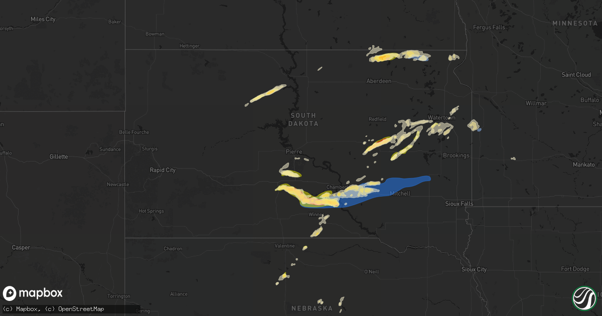
Hail Map in South Dakota on June 3, 2026
Get this storm
June 3 map
$229
one time, instant access
Download today. No call, no setup
Keep the $229
Bought the map and want the full workflow? Apply the entire $229 to a subscription within 7 days. None of it is wasted.
Every map, not just this one
This buys you this map. Subscription and you get every map we run, in the markets you choose from a few cities to whole states to nationwide. Plus real-time alerts the moment a storm fires.
Contact data
Name, contact info, occupancy, even credit band for addresses in the footprint. You go from where it hit to who to call.
Become the source they trust
Unlimited branding weather history reports on demand. You already have the documented answer ready for the property owner, and you are the one who showed up with it.
Property data and RoofTrace estimates
Pull up any address you have got, its value and the exact code rules for that jurisdiction, straight from One Click Code. Then RoofTrace estimates the squares, pitch, and roof value, priced the way you price.
Storm reports in South Dakota
South Dakota
| Date | Description |
|---|---|
| 06/03/20266:40 PM CDT | Video of strong winds and tree damage from storm via facebook. Time estimated from radar. |
| 06/03/20266:40 PM CDT | A local report indicates 1.25 inch wind near 7 NE Broadland |
| 06/03/20266:34 PM CDT | A local report indicates 1.00 inch wind near 4 NE Broadland |
| 06/03/20266:26 PM CDT | A local report indicates 1.50 inch wind near 8 SW Presho |
| 06/03/20266:25 PM CDT | Delayed report. 2 outbuildings lots... Football field score board lost... A pergola structure blew into a home and punched a hole in the wall. A few trees down as well. |
| 06/03/20266:20 PM CDT | Personal weather station. A small building at a football field also destroyed. |
| 06/03/20266:20 PM CDT | Wind damage was reported across frederick from both the emergency manager and the public. Several trees were snapped... And a radio tower was reportedly blown over. The |
| 06/03/20265:40 PM CDT | Pea to ping pong ball sized hail. Time estimated by radar. |
| 06/03/20261:26 PM CDT | Report from mping: quarter |
| 06/03/202612:54 PM CDT | A local report indicates 1.00 inch wind near 3 NE Green Grass |
| 06/02/202610:14 PM CDT | Personal weather station. |
| 06/02/202610:14 PM CDT | Personal weather station. |
| 06/02/20269:20 PM CDT | Mesonet station vnms2 mount vernon |
| 06/02/20268:59 PM CDT | Mesonet station 214 sd rwis plankinton. |
| 06/02/20268:55 PM CDT | Mesonet station wtes2 white lake |
| 06/02/20268:50 PM CDT | A local report indicates 1.00 inch wind near Willow Lake |
| 06/02/20268:35 PM CDT | Mesonet station acms2 academy 3nnw |
| 06/02/20268:30 PM CDT | Hail a bit larger than quarters along with heavy rain. Exact location estimated by radar. |
| 06/02/20268:10 PM CDT | Time estimated by radar. |
| 06/02/20267:52 PM CDT | Winds rocking a pickup filled with equipment... Very heavy downpours also reported. |
| 06/02/20267:42 PM CDT | A local report indicates 69 MPH wind near 4 SW Hillhead |
| 06/02/20267:40 PM CDT | A local report indicates 70 MPH wind near 2 W Hamill |
| 06/02/20267:30 PM CDT | Mesonet station btms2 britton 7e |
| 06/02/20267:29 PM CDT | Time estimated based on radar. Photo submitted via social media. |
| 06/02/20267:20 PM CDT | Tornado on the ground from at least 720 pm to 725 pm cdt per multiple reports and videos from storm chasers. |
| 06/02/20267:18 PM CDT | A local report indicates 1.00 inch wind near 2 N Thomas |
| 06/02/20267:15 PM CDT | Awos station kbtn 1 nne britton. |
| 06/02/20267:15 PM CDT | Time estimated. Chaser was still on edge of hail core. |
| 06/02/20267:10 PM CDT | Near 104th st and 423rd ave... Trees and power lines down. City of britton without power still as of 915pm cdt. Irrigation pivot flipped over. |
| 06/02/20267:10 PM CDT | Along 266th st on the edge of the hail core. |
| 06/02/20267:02 PM CDT | Multiple storm chaser reports of a tornado. Photo and location submitted via social media. |
All States Impacted by Hail Map on June 3, 2026
Cities Impacted by Hail Map on June 3, 2026
- Eagle Butte, SD
- Timber Lake, SD
- Alma, NE
- Oxford, NE
- Orleans, NE
- Whitehorse, SD
- Heartwell, NE
- Holdrege, NE
- Minden, NE
- Beaver, OK
- Atlanta, NE
- Kenesaw, NE
- Juniata, NE
- Turpin, OK
- Balko, OK
- Trail City, SD
- Elwood, NE
- Overton, NE
- Smithfield, NE
- Ashton, NE
- Riverton, NE
- Campbell, NE
- Cairo, NE
- Roseland, NE
- Bladen, NE
- Sumner, NE
- Forgan, OK
- Republican City, NE
- Boelus, NE
- Dannebrog, NE
- Hays, KS
- Bertrand, NE
- Ulysses, KS
- Hugoton, KS
- Perryton, TX
- Childress, TX
- Hastings, NE
- Hildreth, NE
- Bloomington, NE
- Ayr, NE
- Wilcox, NE
- Florissant, CO
- Booker, TX
- Mescalero, NM
- Doniphan, NE
- Trumbull, NE
- Guffey, CO
- Osborne, KS
- Datil, NM
- Kiowa, CO
- Elizabeth, CO
- Westcliffe, CO
- Lakin, KS
- Elfrida, AZ
- Cloudcroft, NM
- Valley City, ND
- Java, SD
- Portland, ND
- Portis, KS
- Castle Rock, CO
- Brighton, CO
- Greeley, CO
- Larimore, ND
- Oriska, ND
- Eureka, SD
- Franktown, CO
- Fort Lupton, CO
- Burwell, NE
- Hill City, KS
- Ellis, KS
- Mayhill, NM
- Eaton, CO
- Gill, CO
- Arapahoe, NE
- Holbrook, NE
- Englewood, KS
- Smith Center, KS
- Gaylord, KS
- Lebanon, KS
- Galeton, CO
- Sweetwater, TX
- Corona, NM
- Willard, NM
- Palco, KS
- Bogue, KS
- Murdo, SD
- Edison, NE
- Cordell, OK
- Rocky, OK
- Saint David, AZ
- Draper, SD
- Buffalo, OK
- Rosston, OK
- Sentinel, OK
- Ashland, KS
- Lebanon, NE
- Briggsdale, CO
- Brewster, NE
- Wessington, SD
- York, NE
- Cambridge, NE
- Wilsonville, NE
- Butler, OK
- Leedey, OK
- Wiggins, CO
- Vici, OK
- Alton, KS
- Natoma, KS
- Las Vegas, NM
- Ribera, NM
- McCool Junction, NE
- Roggen, CO
- Vivian, SD
- Wolsey, SD
- Weldona, CO
- Forbes, ND
- Hammon, OK
- Raton, NM
- Weed, NM
- Logan, KS
- Brownell, KS
- Cawker City, KS
- Safford, AZ
- McCracken, KS
- Sharon, OK
- Maxwell, NM
- Fort Morgan, CO
- New Raymer, CO
- Wood, SD
- Presho, SD
- Frederick, SD
- Morenci, AZ
- Phillipsburg, KS
- Ellendale, ND
- Huron, SD
- Hitchcock, SD
- Hecla, SD
- Ideal, SD
- Winner, SD
- Beaver City, NE
- La Loma, NM
- Anton Chico, NM
- Waldo, KS
- Barnard, SD
- Bushnell, NE
- Pine Bluffs, WY
- Downs, KS
- Crowell, TX
- Witten, SD
- Houghton, SD
- Paradise, KS
- Hayti, SD
- Bryant, SD
- Pukwana, SD
- Lordsburg, NM
- Grand Forks, ND
- Fort Pierre, SD
- Carpenter, SD
- Mekinock, ND
- Manvel, ND
- Doland, SD
- White Lake, SD
- Saint Lawrence, SD
- Britton, SD
- Hazel, SD
- Emerado, ND
- Yale, SD
- Chamberlain, SD
- East Grand Forks, MN
- Tulare, SD
- Hamill, SD
- Reliance, SD
- Gregory, SD
- Watertown, SD
- Selden, KS
- Lake Norden, SD
- Goodwin, SD
- Penokee, KS
- Kimball, SD
- Platte, SD
- Lake City, SD
- Castlewood, SD
- Strandburg, SD
- Willow Lake, SD
- Veblen, SD
- Vienna, SD
- Stockholm, SD
- Colome, SD
- Burke, SD
- Clark, SD
- Wessington Springs, SD
- Alpena, SD
- Grenville, NM
- Rosholt, SD
- New Effington, SD
- Sisseton, SD
- Iroquois, SD
- Cavour, SD
- Wood Lake, NE
- Dallas, SD
- Vado, NM
- Clear Lake, SD
- Mesquite, NM
- Virgil, SD
- Henry, SD
- Plankinton, SD
- Mesilla Park, NM
- Las Cruces, NM
- Raymond, SD
- Thedford, NE
- Woonsocket, SD
- Letcher, SD
- Springview, NE
- Boise City, OK
- Kenton, OK
- La Mesa, NM
- Conchas Dam, NM
- Gary, SD
- Stinnett, TX
- Logan, NM
- Canby, MN
- Marietta, MN
- Dill City, OK
- Canute, OK
- Mount Vernon, SD
- Mitchell, SD
- Artesian, SD
- Fulton, SD
- Fedora, SD
- Howard, SD
- Canova, SD
- Alexandria, SD
- Spencer, SD
- Estelline, SD
- Spearman, TX
- Erick, OK
- Winfred, SD
- Sayre, OK
- Morse, TX
- Elk City, OK
- Mcalister, NM
- Wood Lake, MN
- Grady, NM
- Texhoma, OK
- Tracy, MN
- Walnut Grove, MN
- Portales, NM


