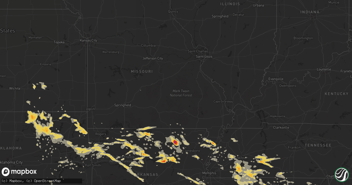
Hail Map on June 3, 2012
Get this storm
June 3 map
$229
one time, instant access
Download today. No call, no setup
Keep the $229
Bought the map and want the full workflow? Apply the entire $229 to a subscription within 7 days. None of it is wasted.
Every map, not just this one
This buys you this map. Subscription and you get every map we run, in the markets you choose from a few cities to whole states to nationwide. Plus real-time alerts the moment a storm fires.
Contact data
Name, contact info, occupancy, even credit band for addresses in the footprint. You go from where it hit to who to call.
Become the source they trust
Unlimited branding weather history reports on demand. You already have the documented answer ready for the property owner, and you are the one who showed up with it.
Property data and RoofTrace estimates
Pull up any address you have got, its value and the exact code rules for that jurisdiction, straight from One Click Code. Then RoofTrace estimates the squares, pitch, and roof value, priced the way you price.
States Impacted by Hail Map on June 3, 2012
Storm reports
Iowa
| Date | Description |
|---|---|
| 06/02/201210:15 PM CDT | Frequent gusts to 60 kts from 1015 to 1029 pm. Pea size hail also observed. Possible downburst. |
| 06/02/20129:24 PM CDT | Mostly pea to dime size hail with a few quarter size stones |
Tennessee
| Date | Description |
|---|---|
| 06/03/20126:50 PM CDT | Wind gust 55 to 60 mph on hwy 142 just south of selmer. |
| 06/03/20126:50 PM CDT | Penny to quarter sized hail on highway 45 just south of selmer |
| 06/03/20122:39 AM CDT | Quarter size hail covering the ground. |
| 06/03/201212:09 AM CDT | Multiple trees/powerlines down at intersection of route 224 and hwy 57 and on tulu and michie road. |
| 06/02/201211:10 PM CDT | Quarter size hail near shiloh. Time estimated from radar. |
| 06/02/201211:10 PM CDT | Several trees down near eastview...mitchie...and stantonville. |
| 06/02/201211:10 PM CDT | Several trees down and a house with some minor damage to the siding near olivet. |
| 06/02/201211:10 PM CDT | Roof blown off home at 1220 post office rd. |
| 06/02/201210:40 PM CDT | A few trees down throughout the county. Time estimated from radar. |
| 06/02/201210:40 PM CDT | Hail up to the size of golf balls reported in bolivar. Time estimated from radar. |
| 06/02/201210:40 PM CDT | 60 mph wind gusts in bolivar. |
| 06/02/201210:20 PM CDT | Tree limbs and power lines down - scattered about the county. |
| 06/02/201210:16 PM CDT | Tree limbs and power lines down across the county...slightly more concentrated over southwestern fayette county. |
| 06/02/201210:15 PM CDT | A few powerlines and trees down in western madison county. |
| 06/02/201210:02 PM CDT | Large tree down near eads with others down across fayette county. Time estimated. |
| 06/02/20129:57 PM CDT | Tree down on house in arlington. Time estimated. |
| 06/02/20129:56 PM CDT | Power lines down on rabbit trail road near leoma...possibly caused by falling tree. |
| 06/02/20129:48 PM CDT | A few powerlines and trees down in western madison county. |
| 06/02/20129:43 PM CDT | 6 trees down near mason. Time is estimated from radar. |
| 06/02/20129:30 PM CDT | 15 to 18 trees down across roads in lauderdale county. Time is estimated from radar. |
| 06/02/20128:55 PM CDT | Golf ball sized hail near michie. |
| 06/02/20128:47 PM CDT | A local report indicates 1.00 inch wind near LINDEN |
| 06/02/20128:47 PM CDT | On u.s. 412 just east of linden a few trees were reported down. |
| 06/02/20128:30 PM CDT | A few trees were downed on centerville highway. |
| 06/02/20128:17 PM CDT | Hail reported on us highway 64 between waynesboro and the giles county line. |
| 06/02/20127:44 PM CDT | Golf ball sized hail in bath springs. |
| 06/02/20127:30 PM CDT | A few trees down on bible hill road. Time estimated by radar. |
| 06/02/20127:20 PM CDT | Reported in white oak community |
New York
| Date | Description |
|---|---|
| 06/03/20125:09 PM CDT | Tree and wires down on union blvd in the bay shore and islip area |
| 06/03/20125:09 PM CDT | Lipa reports wires down due to tree damage to the wires |
| 06/03/20124:55 PM CDT | Large branch and wires down on arnold lane. |
Arkansas
| Date | Description |
|---|---|
| 06/03/20126:56 PM CDT | Trees were blown down. |
| 06/03/20126:55 PM CDT | A local report indicates 2.50 inch wind near HICKORY FLAT |
| 06/03/20126:45 PM CDT | Trees were down in the greers ferry lake area. A tree limb fell on to a power line. Trees were blown down in the devils fork recreation area. |
| 06/03/20126:44 PM CDT | Winds est. At 60 mph. Trees and structure damage reported. Also pea size hail. |
| 06/03/20126:35 PM CDT | A wind gust of 53 mph was measured at the clinton airport. |
| 06/03/20126:33 PM CDT | A local report indicates 1.00 inch wind near OARK |
| 06/03/20126:30 PM CDT | Hail reported on the franklin johnson county line |
| 06/03/20126:20 PM CDT | A local report indicates 1.75 inch wind near 3 ENE DENNARD |
| 06/03/20126:20 PM CDT | Trees were downed in clinton. |
| 06/03/20126:20 PM CDT | A local report indicates 1.50 inch wind near DENNARD |
| 06/03/20126:20 PM CDT | Correction to the report of golf ball size hail 3ene of dennard. Spotter was 3ene of botkinburg. |
| 06/03/20126:15 PM CDT | A local report indicates 1.00 inch wind near 4 N CASS |
| 06/03/20125:39 PM CDT | Hail lasted for about 3 minutes. |
| 06/03/20125:26 PM CDT | A local report indicates 1.75 inch wind near OLYPHANT |
| 06/03/20125:22 PM CDT | Trees reported down. |
| 06/03/20125:22 PM CDT | A 59 mph gust was measured at vendor. |
| 06/03/20125:12 PM CDT | Several large trees down across highway 23 |
| 06/03/20124:40 PM CDT | Several trees and large limbs down near the white river bridge on highway 16 between fayetteville and elkins. Time estimated by radar. |
| 06/03/20124:35 PM CDT | 3 inch diameter live tree limb broken near baldwin on the east side of fayetteville on highway 16. Time estimated by radar. |
| 06/03/20124:34 PM CDT | A local report indicates 1.00 inch wind near 5 NNE COMPTON |
| 06/03/20124:20 PM CDT | 1.5 foot diamter tree uprooted on mcgee st in west fork at about 420 pm. Power is out in parts of west fork also. Relayed by knwa. |
| 06/03/20123:36 AM CDT | Tree limbs down |
| 06/03/20122:50 AM CDT | Powerlines down |
| 06/03/201212:43 AM CDT | A local report indicates 1.75 inch wind near MOUNTAIN HOME |
| 06/03/201212:40 AM CDT | A local report indicates 1.25 inch wind near MOUNTAIN HOME |
| 06/03/201212:40 AM CDT | Trees down on state highway 23 |
| 06/02/20129:10 PM CDT | Tree down on winter creek road near hwy 89 west of mayflower |
| 06/02/20128:55 PM CDT | A local report indicates 1.00 inch wind near BIGELOW |
| 06/02/20128:30 PM CDT | Grain cart over turned in the middle of cr 160 and cr155. |
| 06/02/20128:23 PM CDT | Possible tornado near bay. |
| 06/02/20128:06 PM CDT | Trees down across cr 766 at us 141. |
| 06/02/20128:01 PM CDT | Possible tornado near egypt. |
| 06/02/20128:00 PM CDT | Possible tornado near gosnell. |
| 06/02/20127:54 PM CDT | Multiple tree limbs are down with some damage to a roof. |
| 06/02/20127:47 PM CDT | A local report indicates 61 MPH wind near 3 SE OIL TROUGH |
| 06/02/20127:37 PM CDT | A local report indicates 1.00 inch wind near RUSSELLVILLE |
| 06/02/20127:24 PM CDT | Trees were blown down. |
| 06/02/20127:20 PM CDT | Numerous trees and power lines were blown down...some trees fell on houses. Also there were some fires started by lightning. |
| 06/02/20127:15 PM CDT | Hail just slightly larger than half dollar size reported in smithville. |
| 06/02/20127:12 PM CDT | 4 1/2 inch sized hail reported in smithville. |
| 06/02/20127:00 PM CDT | Power line down at highway 166 and 62. |
Rhode Island
| Date | Description |
|---|---|
| 06/03/20124:05 PM CDT | Ham radio |
Texas
| Date | Description |
|---|---|
| 06/02/20128:20 PM CDT | A local report indicates 63 MPH wind near 2 NW CHILDRESS |
| 06/02/20127:25 PM CDT | A local report indicates 1.75 inch wind near 5 NNW ALANREED |
Missouri
| Date | Description |
|---|---|
| 06/02/20128:23 PM CDT | Mostly golfball size hail with a few slightly larger stones. |
| 06/02/20128:19 PM CDT | Golfball sized hail at intersection of hwy 61 and hwy m. |
| 06/02/20128:04 PM CDT | Quarter sized hail south of hornersville 1/4 mile south of route y in dunklin county. |
Alabama
| Date | Description |
|---|---|
| 06/03/20125:49 PM CDT | Tree down along hwy 22 between kellyton and alexander city |
| 06/03/20124:48 PM CDT | Trees down at the corner of 4th ave and 3rd st ne on the north side of childersburg |
| 06/03/20124:30 PM CDT | A local report indicates 1.00 inch wind near 4 SW CHELSEA |
| 06/03/20124:15 PM CDT | A local report indicates 1.00 inch wind near IRONDALE |
| 06/03/20124:15 PM CDT | Mountian brook fd has received reports of trees and power lines down across the city. |
| 06/03/20124:15 PM CDT | Tree down. |
| 06/03/20124:10 PM CDT | At st vincents hospital. |
| 06/03/20124:10 PM CDT | At wiat studios. |
| 06/03/20124:00 PM CDT | Trees down along state farm hwy in homewood. |
| 06/03/20124:00 PM CDT | Tree down on structure on elsley. |
| 06/03/20123:46 PM CDT | Four trees down. |
| 06/03/20123:44 PM CDT | Trees and power lines down along 1200 block of sipsey road. |
| 06/03/20123:17 PM CDT | Tree and power lines down on se 33rd street in jasper. |
| 06/03/20123:12 PM CDT | Trees down on hwy 69 near dutton hill road. |
| 06/03/20123:05 PM CDT | Tree down in saragossa along langston road. |
| 06/03/20122:50 PM CDT | Tree down along hwy 13 in eldridge. |
| 06/03/20122:30 PM CDT | Large tree limbs down southwest of hackleburg. A medium sized tree was down across county road 167 near hwy 43 north. Also power lines down on county road 176. |
| 06/03/20126:30 AM CDT | Tree down and blocking county road 21 at momon road. |
| 06/03/20125:40 AM CDT | Tree down across st hwy 44 between brilliant and guin. |
| 06/03/20125:40 AM CDT | Tree down across st hwy 44 between brilliant and guin. |
| 06/03/201212:44 AM CDT | Thunderstorm winds blew a tree down that took out some powerlines along north senaca springs drive in trinity. Utility crews working to repair lines. |
| 06/03/201212:40 AM CDT | Tree reported down along sparkman street south of hartselle. Time estimated based on radar. |
| 06/03/201212:22 AM CDT | Thunderstorm winds knocked trees down around the towns of town creek...hatton and courtland. Powerlines down near fishermans resort...just south of the tennessee river. |
| 06/03/201212:20 AM CDT | Quarter size hail was reported. |
| 06/03/201212:15 AM CDT | Several trees down. Power outages likely due to trees falling on powerlines around russellville. Time estimated from radar. |
| 06/03/201212:14 AM CDT | A tree was downed onto a home by thunderstorm winds. |
| 06/03/201212:05 AM CDT | Several power lines were downed by thunderstorm winds. |
| 06/03/201212:05 AM CDT | Several power lines were downed by thunderstorm winds. |
| 06/02/201211:45 PM CDT | A few trees downed and a shutter blown off of a home by thunderstorm winds. |
| 06/02/201210:40 PM CDT | A tree was downed onto a house and a car by thunderstorm winds. |
Pennsylvania
| Date | Description |
|---|---|
| 06/03/20126:50 PM CDT | Roof blown off residence |
| 06/03/20126:35 PM CDT | Trees and wires down on westerly parkway |
| 06/03/20126:18 PM CDT | Trees down in northern part of brockway |
| 06/03/20125:50 PM CDT | Trees and wires down |
| 06/03/20125:30 PM CDT | Trees down in northern part of brockway |
| 06/03/20125:19 PM CDT | Trees down blocking westbound lane of route 770 |
| 06/03/20125:15 PM CDT | Roofs blown off two houses |
| 06/03/20125:10 PM CDT | Power lines and tree limbs across road |
| 06/03/20125:10 PM CDT | Trees and limbs down in millstone township |
| 06/03/20125:07 PM CDT | Trees down in the city of lebanon |
| 06/03/20125:05 PM CDT | Large trees down |
| 06/03/20123:20 PM CDT | A local report indicates 1.00 inch wind near 1 W SAINT PETERSBURG |
| 06/03/20122:47 PM CDT | Reported to media facebook page. Photo shows hail covering ground. |
| 06/03/201212:59 PM CDT | A local report indicates 1.00 inch wind near NEW CASTLE |
| 06/02/20127:00 PM CDT | Emergency manager reported trees and wires down countywide |
Minnesota
| Date | Description |
|---|---|
| 06/02/20127:20 PM CDT | This tornado tracked to the east-southeast for about 3 miles to around 2 wsw of alvarado by 729 pm cdt. The tornado snapped several trees and limbs while scattering bra |
North Dakota
| Date | Description |
|---|---|
| 06/03/20126:16 PM CDT | This tornado continued from northeastern walsh county into marshall county. It tracked intermittently for about 3 more miles to about 10 wnw of stephen by 625 pm cdt. S |
| 06/03/20126:07 PM CDT | Emergency management report of tornado touchdown along i29 near drayton. |
| 06/03/20126:07 PM CDT | Emergency management reported a brief tornado touchdown along i29 near the south drayton exit. The tornado then tracked intermittently to the southeast for about 3 mile |
| 06/03/20126:07 PM CDT | Emergency management report of a brief tornado touchdown along i29 near drayton. |
| 06/02/20127:16 PM CDT | Public report with pictures made via facebook to local media and then with youtube video post. Time estimated from radar. The tornado appears to have started as ground |
| 06/02/20127:02 PM CDT | A persistent funnel was viewed from exit 168 on interstate 29. Intermittent tornado touchdowns occurred along about a 3 mile path to near 5 e of warsaw by 709 pm cdt. S |
Nevada
| Date | Description |
|---|---|
| 06/02/201210:38 PM CDT | Dry microburst at desatoya mountain raws...6200 ft amsl |
Oklahoma
| Date | Description |
|---|---|
| 06/03/20126:30 PM CDT | A local report indicates 1.75 inch wind near 1 NE SLAPOUT |
| 06/03/20123:27 AM CDT | Large tree limbs down |
| 06/03/20123:05 AM CDT | Tree limbs down across county roads. |
| 06/03/20123:04 AM CDT | Tree down on barn |
| 06/03/20123:00 AM CDT | A local report indicates 62 MPH wind near 2 S WYNONA |
| 06/03/20122:30 AM CDT | Roof blown off house |
| 06/03/20122:10 AM CDT | A local report indicates 58 MPH wind near 4 W HECTORVILLE |
| 06/03/20122:00 AM CDT | Damage to fireworks stands near 101st and memorial. Numerous reports of downed tree limbs across the city. |
| 06/03/20122:00 AM CDT | A local report indicates 60 MPH wind near COWETA |
| 06/03/20121:55 AM CDT | A local report indicates 65 MPH wind near BROKEN ARROW |
| 06/03/20121:45 AM CDT | 2 foot diameter tree downed. Relayed by kjrh meteorologist. Time estimated by radar. |
| 06/03/20121:45 AM CDT | Tree blown over onto house on 101st street between memorial and sheridan in south tulsa. |
| 06/03/20121:40 AM CDT | A local report indicates 65 MPH wind near 4 W COLCORD |
| 06/03/20121:20 AM CDT | Tree blown onto a house. Numerous reports of power outages. |
| 06/03/201212:05 AM CDT | Big tree down on house |
| 06/02/201211:13 PM CDT | The hail was reported near county roads e1140 and n2510. |
| 06/02/201210:15 PM CDT | A local report indicates 67 MPH wind near 5 SW BUTLER |
| 06/02/201210:10 PM CDT | A local report indicates 73 MPH wind near 5 SW BUTLER |
| 06/02/20127:13 PM CDT | A local report indicates 1.00 inch wind near GATE |
| 06/02/20127:05 PM CDT | A local report indicates 1.00 inch wind near GATE |
Maryland
| Date | Description |
|---|---|
| 06/03/20126:52 PM CDT | Tree knocked down onto power lines near intersection of regwood rd and catalpa rd. |
| 06/03/20126:40 PM CDT | Tree knocked down and blocking driveway at 16450 hutchins mill rd |
| 06/03/20126:37 PM CDT | Tree down near intersection of sherwood rd and warren rd |
| 06/03/20126:30 PM CDT | Tree knocked down near intersection of crondall ln and garrison forest rd |
| 06/03/20126:20 PM CDT | A 40 to 50 foot tree about 18 inches in diameter was knocked down. |
Georgia
| Date | Description |
|---|---|
| 06/03/20121:15 AM CDT | The public estimated one inch hail lasting for a short time six miles east of dawsonville. |
| 06/03/20121:15 AM CDT | The public estimated one inch hail lasting for a short time six miles east of dawsonville. |
| 06/03/20121:00 AM CDT | Emergency manager reported one tree down in the summerville area. |
| 06/03/201212:50 AM CDT | Two trees along with limbs and branches were reported down along wilderness parkway in big canoe. |
Mississippi
| Date | Description |
|---|---|
| 06/03/20126:38 AM CDT | Multiple trees down and some topped. |
| 06/03/20125:13 AM CDT | Multiple trees down and some topped. |
| 06/03/20124:30 AM CDT | Multiple trees down along hwy45 north of baldwyn. |
| 06/03/20124:25 AM CDT | A local report indicates 70 MPH wind near BOONEVILLE |
| 06/02/201211:45 PM CDT | Numerous trees down in north crossroads area with a report of one trapped due to a tree on a home. |
| 06/02/201211:40 PM CDT | Numerous trees down and power lines down across alcorn county. |
| 06/02/201211:25 PM CDT | Quarter sized hail in falkner. |
Cities Impacted by Hail Map on June 3, 2012
- Pocahontas, TN
- Center Ridge, AR
- Hattieville, AR
- Cleveland, AR
- Mountain Home, AR
- Oakland, AR
- Gainesville, MO
- Clarkridge, AR
- Childress, TX
- Bradford, AR
- Oil Trough, AR
- Thida, AR
- Mclean, TX
- Pampa, TX
- Laverne, OK
- Stuart, OK
- Mcalester, OK
- Oxford, MS
- Minto, ND
- London, AR
- Lamar, AR
- Dover, AR
- Russellville, AR
- Trumann, AR
- Marked Tree, AR
- Shelby, AL
- Sylacauga, AL
- Barnsdall, OK
- Ochelata, OK
- Eufaula, OK
- Iuka, MS
- Cherokee, AL
- Hughes, AR
- Bartlesville, OK
- Dewey, OK
- Clinton, AR
- Scotland, AR
- Blytheville, AR
- Burns, WY
- Pine Bluffs, WY
- Wagoner, OK
- Hulbert, OK
- Chouteau, OK
- Locust Grove, OK
- Clarksville, AR
- Hartman, AR
- Ozark, AR
- Moline, KS
- Grenola, KS
- Shiloh, TN
- Counce, TN
- Burt, IA
- Canehill, AR
- Lincoln, AR
- Prairie Grove, AR
- Broadwater, NE
- Bridgeport, NE
- Dalton, NE
- Jerusalem, AR
- Fairfield, AL
- Birmingham, AL
- Kennett, MO
- Hornersville, MO
- Senath, MO
- Pelham, AL
- Tuscumbia, AL
- Elizabeth, AR
- Jasper, GA
- Reydon, OK
- Rector, AR
- Corinth, MS
- Canadian, TX
- Linden, TN
- Smithville, AR
- Poughkeepsie, AR
- Strawberry, AR
- Black Rock, AR
- Mason, TN
- Bigelow, AR
- Walnut, MS
- Falkner, MS
- Ripley, MS
- Saulsbury, TN
- Middleton, TN
- Grand Junction, TN
- Rienzi, MS
- Tiplersville, MS
- Glen, MS
- Booneville, MS
- Columbiana, AL
- Weogufka, AL
- Mount Judea, AR
- Western Grove, AR
- Vendor, AR
- Hasty, AR
- Jasper, AR
- Hominy, OK
- Skiatook, OK
- Michie, TN
- Ramer, TN
- Guys, TN
- Selmer, TN
- Tishomingo, MS
- Tulsa, OK
- Owasso, OK
- Catoosa, OK
- Claremore, OK
- Webbers Falls, OK
- Porum, OK
- Savannah, TN
- Hagarville, AR
- Ravenden, AR
- Williford, AR
- Evening Shade, AR
- Powhatan, AR
- Lynn, AR
- Gates, TN
- Halls, TN
- Ripley, TN
- Burnsville, MS
- Gate, OK
- Batesville, MS
- Taylor, MS
- Water Valley, MS
- Madison, AL
- Chester, AR
- Mountainburg, AR
- Tahlequah, OK
- Quitaque, TX
- Clarendon, TX
- Talala, OK
- Coldwater, MS
- Severy, KS
- Eureka, KS
- Fairfield Bay, AR
- Dennard, AR
- Pelsor, AR
- Parthenon, AR
- Hindsville, AR
- Harrison, AR
- Hector, AR
- Wesley, AR
- Edgemont, AR
- Alpena, AR
- Higden, AR
- Marble Falls, AR
- Marshall, AR
- Leslie, AR
- Kingston, AR
- Green Forest, AR
- Witts Springs, AR
- Huntsville, AR
- Elkins, AR
- Compton, AR
- Saint Joe, AR
- Tilly, AR
- Shirley, AR
- Berryville, AR
- Deer, AR
- Lester, AL
- Brilliant, AL
- Haleyville, AL
- Kenton, TN
- Trimble, TN
- Hickory Valley, TN
- Elk City, OK
- Butler, OK
- Calico Rock, AR
- Carpenter, WY
- Marmaduke, AR
- Steele, MO
- Gobler, MO
- Boyers, PA
- Eau Claire, PA
- Parker, PA
- Hilliards, PA
- Atkins, AR
- Welch, OK
- Delaware, OK
- Vinita, OK
- Lenapah, OK
- Sulligent, AL
- Greenwood Springs, MS
- Sweetwater, OK
- Alton, MO
- Hamilton, AL
- Tremont, MS
- Dennis, MS
- Hammon, OK
- Fairfax, OK
- Wynona, OK
- Collinsville, OK
- Sperry, OK
- Broken Arrow, OK
- Brickeys, AR
- Pleasant Plains, AR
- Rosie, AR
- Newport, AR
- Afton, OK
- New Site, MS
- Marietta, MS
- Eucha, OK
- Lynn, AL
- Pocahontas, AR
- Ravenden Springs, AR
- Sand Springs, OK
- Alabaster, AL
- Chelsea, AL
- Hornsby, TN
- Bethel Springs, TN
- Adamsville, TN
- Stantonville, TN
- Mercer, TN
- Henderson, TN
- Toone, TN
- Bolivar, TN
- Medon, TN
- Park Hill, OK
- Stilwell, OK
- Bunch, OK
- Welling, OK
- Evansville, AR
- Leon, KS
- Rosalia, KS
- Russellville, AL
- Leighton, AL
- Monette, AR
- Cardwell, MO
- Leachville, AR
- Arbyrd, MO
- Combs, AR
- Fayetteville, AR
- Bixby, OK
- Crump, TN
- Olivehill, TN
- Saltillo, MS
- Mooreville, MS
- Mantachie, MS
- Baldwyn, MS
- Nettleton, MS
- Fulton, MS
- Guntown, MS
- Amory, MS
- Plantersville, MS
- Tupelo, MS
- Detroit, AL
- Smithville, MS
- Sterrett, AL
- Vincent, AL
- Lu Verne, IA
- Goldfield, IA
- Corwith, IA
- Renwick, IA
- Waynesboro, TN
- Bluejacket, OK
- La Fayette, GA
- Scotts Hill, TN
- Hohenwald, TN
- Decaturville, TN
- Darden, TN
- Lexington, TN
- Parsons, TN
- Clifton, TN
- Bath Springs, TN
- Loretto, TN
- Leoma, TN
- Colony, OK
- Lookeba, OK
- Corn, OK
- Hydro, OK
- Farmington, AR
- Onia, AR
- Timbo, AR
- Newkirk, OK
- Shidler, OK
- Burbank, OK
- Kaw City, OK
- Clinton, OK
- Cheyenne, OK
- Jay, OK
- Brighton, TN
- McCrory, AR
- Floral, AR
- Everton, AR
- Cherryvale, KS
- Mound Valley, KS
- Mountain View, AR
- Drasco, AR
- Wilburn, AR
- Heber Springs, AR
- Pangburn, AR
- Batesville, AR
- Locust Grove, AR
- Concord, AR
- Judsonia, AR
- Tumbling Shoals, AR
- Marcella, AR
- Brownsville, TN
- Cleveland, OK
- Duncombe, IA
- Webster City, IA
- Stratford, IA
- Fort Dodge, IA
- Lehigh, IA
- Gassville, AR
- Midway, AR
- Melbourne, AR
- Bessemer, AL
- Reagan, TN
- Enville, TN
- Dyer, TN
- Newbern, TN
- Mounds, OK
- Beggs, OK
- Senatobia, MS
- Morrilton, AR
- Adona, AR
- Pottsville, AR
- Dardanelle, AR
- Sedan, KS
- Westville, OK
- Morrow, AR
- Rudy, AR
- Maple City, KS
- Cookson, OK
- Pawhuska, OK
- Knoxville, AR
- Sallisaw, OK
- Perry, AR
- West Fork, AR
- Inola, OK
- Ramona, OK
- Winslow, AR
- Mayflower, AR
- Houston, AR
- Mulberry, AR
- Mannford, OK
- Ponca City, OK
- Prue, OK
- Fort Gibson, OK
- Proctor, OK
- Oark, AR
- Terlton, OK
- Osage, OK
- Jennings, OK
- Roland, AR
- Copan, OK
- Spavinaw, OK
- Strang, OK
- Grove, OK
- Colcord, OK
- Drayton, ND
- Lakeview, TX
- Moulton, AL
- Warner, OK
- Burlison, TN
- Guion, AR
- Mount Pleasant, AR
- Talking Rock, GA
- Gainesville, GA
- Colt, AR
- Cotton Plant, AR
- Palestine, AR
- Brockwell, AR
- Arlington, TN
- Pulaski, TN
- Okemah, OK
- Saffell, AR
- Graysville, AL
- Adamsville, AL
- Foss, OK
- Custer City, OK
- Como, MS
- Sardis, MS
- Red Lodge, MT
- Huron, TN
- Jacks Creek, TN
- Cedar Vale, KS
- Dawsonville, GA
- Cumming, GA
- Marble Hill, GA
- Rose Bud, AR
- Jasper, AL
- Carbon Hill, AL
- Guin, AL
- Winfield, AL
- Eldridge, AL
- Nauvoo, AL
- Oak Grove, AR
- Omaha, AR
- Lockney, TX
- Cave City, AR
- Sulphur Rock, AR
- Belmont, MS
- Somerville, TN
- Whiteville, TN
- Salina, OK
- Rose, OK
- Hernando, MS
- Robinsonville, MS
- Marianna, AR
- Forrest City, AR
- Ranger, GA
- Memphis, TX
- Chickamauga, GA
- Hoxie, AR
- Walnut Ridge, AR
- El Dorado, KS
- Hillsdale, WY
- Keota, OK
- Sardis, TN
- Blue Springs, MS
- Bristow, OK
- Drumright, OK
- Hardy, AR
- Sidney, NE
- Checotah, OK
- Wood River Junction, RI
- Carolina, RI
- Wyoming, RI
- Sidney, AR
- Udall, MO
- Yellville, AR
- Bakersfield, MO
- Peel, AR
- Caulfield, MO
- Pontiac, MO
- Town Creek, AL
- Hillsboro, AL
- Courtland, AL
- Kanawha, IA
- Caledonia, MS
- Gattman, MS
- Alvarado, MN
- Oslo, MN
- Swifton, AR
- Ash Flat, AR
- Alicia, AR
- Tuckerman, AR
- Cord, AR
- Portia, AR
- Imboden, AR
- Finley, TN
- Florence, AL
- Norfork, AR
- Lafe, AR
- Ozone, AR
- Oologah, OK
- Blanco, OK
- Hartshorne, OK
- Bokoshe, OK
- Mccurtain, OK
- Ridgedale, MO
- Pineville, AR
- Gardendale, AL
- Bull Shoals, AR
- Flippin, AR
- Cotter, AR
- Lakeview, AR
- Morris Chapel, TN
- Milledgeville, TN
- Athens, AL
- Elkmont, AL
- Pinson, AL
- Hanna, OK
- Pisgah, AL
- Stigler, OK
- Bozeman, MT
- Aberdeen, MS
- Hamilton, MS
- Vernon, AL
- Thayer, MO
- Foxburg, PA
- Emlenton, PA
- Lead Hill, AR
- Summit, AR
- Cheyenne, WY
- Cavalier, ND
- Natural Dam, AR
- Uniontown, AR
- Anderson, AL
- Lexington, AL
- Rogersville, AL
- Algona, IA
- Bells, TN
- Spruce Pine, AL
- Geary, OK
- Crook, CO
- Lepanto, AR
- Amagon, AR
- Wilsonville, AL
- Harpersville, AL
- Leeds, AL
- Goodwater, AL
- Childersburg, AL
- Pleasant Grove, AL
- Munford, TN
- Henning, TN
- Covington, TN
- Killen, AL
- Mount Hope, AL
- Waterloo, AL
- Golden, MS
- Oktaha, OK
- Harrisburg, AR
- Muskogee, OK
- Council Hill, OK
- Bono, AR
- Beaverton, AL
- Franklin, AR
- Lawrenceburg, TN
- Five Points, TN
- Westpoint, TN
- Saint Joseph, TN
- Iron City, TN
- Minor Hill, TN
- Turkey, TX
- Pontotoc, MS
- Houlka, MS
- Argyle, MN
- Fort Payne, AL
- Collinsville, AL
- Ada, OK
- Big Flat, AR
- Harriet, AR
- Portales, NM
- Hollywood, AL
- Sage, AR
- Collinwood, TN
- Cypress Inn, TN
- Thaxton, MS
- Berry, AL
- Michigan City, MS
- Ashland, MS
- Hollytree, AL
- New Market, AL
- Princeton, AL
- Gurley, AL
- Sapulpa, OK
- Watts, OK
- Summers, AR
- Rutherford, TN
- Winfield, KS
- Muldrow, OK
- Alpine, TX
- Lone Rock, IA
- Bancroft, IA
- Burden, KS
- Abbeville, MS
- Centerville, TN
- Washburn, MO
- Exeter, MO
- Rocky Comfort, MO
- Couch, MO
- Durham, OK
- Denmark, TN
- Finger, TN
- Lutts, TN
- Pinson, TN
- Jackson, TN
- Hartselle, AL
- Danville, AL
- Kiowa, OK
- Magness, AR
- Newark, AR
- Scottsboro, AL
- Jonesboro, AR
- Cropwell, AL
- Arab, AL
- Quanah, TX
- Ball Ground, GA
- Hedley, TX
- Courtland, MS
- Pleasant Grove, AR
- Coffeyville, KS
- Valley Springs, AR
- Hackleburg, AL
- Paragould, AR
- S Coffeyville, OK
- Vina, AL
- Columbus, MS
- Eagle Rock, MO
- West Kingston, RI
- Beech Bluff, TN
- Briscoe, TX
- Cedarville, AR
- Luxora, AR
- Liberty, KS
- Okmulgee, OK
- Warm Springs, AR
- Gatewood, MO
- Oakland, TN
- Fifty Six, AR
- Parrish, AL
- Townley, AL
- Oakman, AL
- Bankston, AL
- Crossville, AL
- Sheffield, AL
- Muscle Shoals, AL
- Fairmount, GA
- Anderson, MO