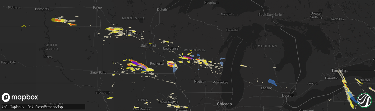
Hail Map in Wisconsin on June 2, 2020
The weather event in Wisconsin on June 2, 2020 includes Hail and Wind maps. 14 states and 696 cities were impacted and suffered possible damage. The total estimated number of properties impacted is 17,920.
Want more than just the map?
Turn this storm into a full workflow.
- Owner + property data so you know who to knock
- OnDemand branded weather history reports to win the "did we even have hail?" argument
- RoofTrace estimate so reps stop guessing numbers at the door
Bought this map? Upgrade within 7 days and we'll credit the $230. (10-15 min setup call)
Hail
Wind
17,920
Estimated number of impacted properties by a 1.00" hail or larger6,320
Estimated number of impacted properties by a 1.75" hail or larger6,627
Estimated number of impacted properties by a 2.50" hail or largerStorm reports in Wisconsin
Wisconsin
| Date | Description |
|---|---|
| 06/02/20206:55 PM CDT | Relayed by wsaw. |
| 06/02/20206:54 PM CDT | . |
| 06/02/20206:50 PM CDT | A local report indicates 61 MPH wind near WISCONSIN RAPIDS |
| 06/02/20206:50 PM CDT | Several trees and large branches blown down. |
| 06/02/20206:50 PM CDT | Large tree down and other branches. |
| 06/02/20206:49 PM CDT | 6 inch diameter tree branch snapped at main and north avenue. Report via social media. |
| 06/02/20206:46 PM CDT | Damage to trees... Roofs... And siding. |
| 06/02/20206:46 PM CDT | Canopy blown off top of grandstand at county fairgrounds. Lots of tree damage in area as well. |
| 06/02/20206:45 PM CDT | 2 large pine trees blown down. |
| 06/02/20206:41 PM CDT | A local report indicates 1.00 inch wind near 2 SSE HOLMEN |
| 06/02/20206:40 PM CDT | Numerous trees and power lines reported down across the county from earlier storm. Time estimated from radar. |
| 06/02/20206:40 PM CDT | Relayed via social media. |
| 06/02/20206:36 PM CDT | One large limb down on corner of losey blvd and main st. Time estimated from radar. |
| 06/02/20206:35 PM CDT | 5 large trees blown down. |
| 06/02/20206:35 PM CDT | Two large limbs down on bliss road... Partially blocking downhill lane. Time estimated from radar. |
| 06/02/20206:35 PM CDT | Report relayed via social media. |
| 06/02/20206:33 PM CDT | A local report indicates 59 MPH wind near ONALASKA |
| 06/02/20206:32 PM CDT | Powerlines blown down on county rd z. |
| 06/02/20206:30 PM CDT | Relayed via social media photo with ruler. |
| 06/02/20206:27 PM CDT | Corrected from non-tstm wnd gst to tstm wind gust. Asos station klse la crosse regional airport. |
| 06/02/20206:25 PM CDT | Via social media photo. Estimated around 2.5 inches. Time estimated from radar. |
| 06/02/20206:25 PM CDT | Est. 65 mph wind gusts with squall that lasted 10 min. Large branches and trees down. |
| 06/02/20206:20 PM CDT | A local report indicates 1.00 inch wind near 1 WSW WEST SALEM |
| 06/02/20206:20 PM CDT | Relayed via social media. Photo of quarter to half dollar sized hail stones. |
| 06/02/20206:15 PM CDT | A local report indicates 1.00 inch wind near BABCOCK |
| 06/02/20206:15 PM CDT | Several trees blown down. |
| 06/02/20206:15 PM CDT | Large tree branch down. Relayed via social media. |
| 06/02/20206:15 PM CDT | A local report indicates 1.25 inch wind near HOLMEN |
| 06/02/20206:14 PM CDT | One large tree uprooted and another large limb down at drugans. Time estimated from radar. |
| 06/02/20206:11 PM CDT | Several trees blown down. |
| 06/02/20206:10 PM CDT | A local report indicates 1.75 inch wind near 2 SW DODGE |
| 06/02/20206:08 PM CDT | Via social media photo. Estimated around 2.5 inches... But could be slightly larger. Time estimated from radar. |
| 06/02/20206:05 PM CDT | Several large trees blown down. |
| 06/02/20206:05 PM CDT | Several large branches and trees blown down. |
| 06/02/20206:05 PM CDT | A local report indicates 1.25 inch wind near TREMPEALEAU |
| 06/02/20205:59 PM CDT | Seevral large trees were blown down. |
| 06/02/20205:50 PM CDT | Relayed via social media photo. |
| 06/02/20205:50 PM CDT | Trees down. |
| 06/02/20205:50 PM CDT | . |
| 06/02/20205:35 PM CDT | Corrected time on report. |
| 06/02/20205:28 PM CDT | A local report indicates 1.75 inch wind near 3 WSW PRAY |
| 06/02/20204:45 PM CDT | Mostly dime to nickel sized hail. |
| 06/02/20204:26 AM CDT | At 926 PM CDT, severe thunderstorms were located along a line extending from near Cleveland to near Cedar Grove, moving east at 45 mph. HAZARD...60 mph wind gusts and penny size hail. SOURCE...Radar indicated. IMPACT...Expect damage to roofs, siding, and trees. Locations impacted include... Sheboygan, Sheboygan Falls, Howards Grove, Oostburg, Kohler, Cedar Grove, Random Lake, Adell, Waldo, Haven, Johnsonville, Gibbsville and Hingham.People attending Outdoor Testing at St. Nicholas in Sheboygan shouldseek safe shelter immediately! |
| 06/02/20203:44 AM CDT | At 843 PM CDT, severe thunderstorms were located along a line extending from 7 miles west of Plymouth to near Watertown, moving east at 45 mph. HAZARD...60 mph wind gusts and penny size hail. SOURCE...Radar indicated. IMPACT...Expect damage to roofs, siding, and trees. Locations impacted include... West Bend, Mequon, Hartford, Grafton, Cedarburg, Port Washington, Jackson, Slinger, Saukville, Bayside, Kewaskum, Thiensville, Belgium, Fredonia, Newburg, Richfield, Addison, Wayne, Nenno and Waubeka.People attending Washington County Outdoor Testing, Outdoor Testingat Ascension in Mequon, Outdoor Testing at Aurora in Grafton, andOutdoor Testing at Aurora in Hartford should seek safe shelterimmediately! |
| 06/02/20203:37 AM CDT | At 836 PM CDT, severe thunderstorms were located along a line extending from near High Cliff State Park to 7 miles southeast of Northern Lake Winnebago to near Central Lake Winnebago to near Southern Lake Winnebago, moving east at 25 mph. HAZARD...60 mph wind gusts and nickel size hail. SOURCE...Radar indicated. IMPACT...Expect damage to roofs, siding, and trees. Locations impacted include... Manitowoc, Kewaunee, Chilton, Brillion, Denmark, Cleveland, Valders, St. Nazianz, Two Creeks and St Anna. |
| 06/02/20203:27 AM CDT | At 826 PM CDT, severe thunderstorms were located along a line extending from near Camp Rokilio Scout Camp to 6 miles southwest of Oakfield, moving east at 45 mph. HAZARD...60 mph wind gusts and quarter size hail. SOURCE...Radar indicated. IMPACT...Hail damage to vehicles is expected. Expect wind damage to roofs, siding, and trees. Locations impacted include... Sheboygan, Fond Du Lac, Plymouth, Sheboygan Falls, North Fond Du Lac, Howards Grove, Oostburg, Kohler, Cedar Grove, Campbellsport, Random Lake, Rosendale, Elkhart Lake, Southern Lake Winnebago, Taycheedah, Ashford, Greenbush, Eden, Mount Calvary and Cascade.People attending Outdoor Testing at Prevea in Plymouth, and OutdoorTesting at St. Nicholas in Sheboygan should seek safe shelterimmediately! |
| 06/02/20203:12 AM CDT | At 811 PM CDT, severe thunderstorms were located along a line extending from Northern Lake Winnebago to Central Lake Winnebago to near Oshkosh to 8 miles northwest of North Fond Du Lac, moving east at 35 mph. HAZARD...60 mph wind gusts and half dollar size hail. SOURCE...Trained weather spotters. IMPACT...Hail damage to vehicles is expected. Expect wind damage to roofs, siding, and trees. Locations impacted include... Oshkosh, Menasha, Chilton, Brillion, St Anna, Central Lake Winnebago, Northern Lake Winnebago, High Cliff State Park, Neenah and Harrison. |
| 06/02/20203:06 AM CDT | At 805 PM CDT, severe thunderstorms were located along a line extending from near Poynette to 10 miles southwest of Spring Green, moving south at 60 mph. HAZARD...60 mph wind gusts. SOURCE...Radar indicated. IMPACT...Expect damage to roofs, siding, and trees. Locations impacted include... Madison, Sun Prairie, Fitchburg, Middleton, Stoughton, Waunakee, Verona, Oregon, McFarland, Monona, Mount Horeb, Windsor, Edgerton, Dodgeville, Marshall, Sauk City, Mineral Point, Deforest, Cottage Grove and Cross Plains. |
| 06/02/20203:03 AM CDT | At 802 PM CDT, severe thunderstorms were located along a line extending from near Rosendale to 7 miles northwest of Cambria, moving southeast at 35 mph. HAZARD...60 mph wind gusts and quarter size hail. SOURCE...Law enforcement. IMPACT...Hail damage to vehicles is expected. Expect wind damage to roofs, siding, and trees. Locations impacted include... Fond Du Lac, Waupun, Mayville, Horicon, Lomira, Markesan, Theresa, Oakfield, Brandon, Burnett, Lamartine, Byron, Fox Lake, Alto, Manchester, Brownsville, Fairwater, Kingston, Kekoskee and Atwater. |
| 06/02/20202:57 AM CDT | At 756 PM CDT, severe thunderstorms were located along a line extending from 9 miles northeast of Pardeeville to near Portage, moving southeast at 55 mph. HAZARD...60 mph wind gusts and quarter size hail. SOURCE...Law enforcement. IMPACT...Hail damage to vehicles is expected. Expect wind damage to roofs, siding, and trees. Locations impacted include... Watertown, Beaver Dam, Hartford, Portage, Columbus, Horicon, Juneau, Poynette, Pardeeville, Randolph, Fall River, Hustisford, Rio, Iron Ridge, Cambria, Ashippun, Rubicon, Lebanon, Fox Lake and Arlington. |
| 06/02/20202:51 AM CDT | At 751 PM CDT, severe thunderstorms were located along a line extending from Central Lake Winnebago to near Green Lake, moving east at 40 mph. HAZARD...60 mph wind gusts and quarter size hail. SOURCE...Radar indicated. IMPACT...Hail damage to vehicles is expected. Expect wind damage to roofs, siding, and trees. Locations impacted include... Fond Du Lac, Waupun, Ripon, North Fond Du Lac, Oakfield, Rosendale, Brandon, Southern Lake Winnebago, Taycheedah, Lamartine, Alto, Mount Calvary, St. Cloud, Fairwater, Peebles, Pipe, Lagoda, Calvary, Marytown and Johnsburg. |
| 06/02/20202:24 AM CDT | At 724 PM CDT, severe thunderstorms were located along a line extending from near Lake Poygan to 6 miles north of Berlin to Redgranite, moving southeast at 35 mph. HAZARD...60 mph wind gusts and quarter size hail. SOURCE...Radar indicated. IMPACT...Hail damage to vehicles is expected. Expect wind damage to roofs, siding, and trees. Locations impacted include... Appleton, Oshkosh, Menasha, Redgranite, Central Lake Winnebago, Lake Poygan, Rush Lake, Northern Lake Winnebago, Neenah and Omro. |
| 06/02/20202:12 AM CDT | At 711 PM CDT, severe thunderstorms were located along a line extending from near Wautoma to near Westfield, moving southeast at 30 mph. HAZARD...60 mph wind gusts and quarter size hail. SOURCE...Radar indicated. IMPACT...Hail damage to vehicles is expected. Expect wind damage to roofs, siding, and trees. Locations impacted include... Berlin, Montello, Markesan, Westfield, Princeton, Green Lake, Lawrence, Manchester, Neshkoro, Kingston, Marquette, Glen Oak, Harrisville, Springfield Corners and Dalton. |
| 06/02/20202:06 AM CDT | At 706 PM CDT, severe thunderstorms were located along a line extending from Dellwood to 9 miles northwest of Hillsboro to near Stoddard, moving southeast at 40 mph. HAZARD...60 mph wind gusts and quarter size hail. SOURCE...Radar indicated. IMPACT...Hail damage to vehicles is expected. Expect wind damage to roofs, siding, and trees. Locations impacted include... Baraboo, Portage, Reedsburg, Wisconsin Dells, Lake Delton, West Baraboo, Packwaukee, North Freedom, Oxford, Endeavor, La Valle, Rock Springs, Loganville, Ironton, Lime Ridge, Glen Oak, Leland, Briggsville, Devils Lake St Park and Hill Point. |
| 06/02/20201:59 AM CDT | At 658 PM CDT, severe thunderstorms were located along a line extending from near Necedah to 7 miles northwest of Elroy to near Westby, moving southeast at 55 mph. HAZARD...70 mph wind gusts and half dollar size hail. SOURCE...Radar indicated. IMPACT...Hail damage to vehicles is expected. Expect considerable tree damage. Wind damage is also likely to mobile homes, roofs, and outbuildings. Severe thunderstorms will be near... Elroy and Hillsboro around 705 PM CDT. Wonewoc around 710 PM CDT. Richland Center around 730 PM CDT.Other locations impacted by these severe thunderstorms includeJohnson Hill, Big Spring, Highway 80 And County C C, Gillingham,Trippville, Neptune and County Roads A And Z. |
| 06/02/20201:44 AM CDT | At 644 PM CDT, a severe thunderstorm was located 7 miles north of Dellwood, or 9 miles northwest of Friendship, moving east at 35 mph. HAZARD...60 mph wind gusts and quarter size hail. SOURCE...Radar indicated. IMPACT...Hail damage to vehicles is expected. Expect wind damage to roofs, siding, and trees. This severe thunderstorm will be near... Friendship and Adams around 700 PM CDT.Other locations impacted by this severe thunderstorm include Highways13 And 21, County Roads G And O, County Roads G And M, County Roads CAnd G, Lake Sherwood, The Preston Cliffs and Grand Marsh. |
| 06/02/20201:42 AM CDT | At 642 PM CDT, a cluster of severe thunderstorms was located 9 miles northwest of Stevens Point, moving east at 30 mph. HAZARD...60 mph wind gusts and half dollar size hail. SOURCE...Radar indicated. IMPACT...Hail damage to vehicles is expected. Expect wind damage to roofs, siding, and trees. Locations impacted include... Stevens Point, Waupaca, Wautoma, Redgranite, Whiting, Amherst, Plainfield, Fremont, Napowan Scout Camp and Hartman Creek State Park. |
| 06/02/20201:25 AM CDT | At 624 PM CDT, severe thunderstorms were located along a line extending from 10 miles east of Millston to near Fort Mc Coy to near Sparta, moving east at 55 mph. HAZARD...60 mph wind gusts and quarter size hail. SOURCE...Radar indicated. IMPACT...Hail damage to vehicles is expected. Expect wind damage to roofs, siding, and trees. Severe thunderstorms will be near... Tomah around 635 PM CDT. Necedah around 650 PM CDT. New Lisbon around 655 PM CDT. Elroy around 700 PM CDT.Other locations impacted by these severe thunderstorms include NewMiner, Franklin, Shamrock, The Black River Correctional Center, CampDecorah, Stevenstown and Potters Flowage. |
| 06/02/20201:11 AM CDT | At 611 PM CDT, a severe thunderstorm was located over Babcock, or 17 miles southwest of Wisconsin Rapids, moving southeast at 25 mph. HAZARD...70 mph wind gusts and ping pong ball size hail. SOURCE...Radar indicated. IMPACT...People and animals outdoors will be injured. Expect hail damage to roofs, siding, windows, and vehicles. Expect considerable tree damage. Wind damage is also likely to mobile homes, roofs, and outbuildings. Locations impacted include... Wisconsin Rapids, Marshfield, Pittsville, Babcock, Lake Wazeecha, Nekoosa, Port Edwards, Biron, Hewitt and Sherry. |
| 06/02/20201:09 AM CDT | At 609 PM CDT, a cluster of severe thunderstorms were located near Hatfield, or 8 miles southwest of Neillsville, moving east at 45 mph. HAZARD...Ping pong ball size hail and 60 mph wind gusts. SOURCE...Radar indicated. IMPACT...People and animals outdoors will be injured. Expect hail damage to roofs, siding, windows, and vehicles. Expect wind damage to roofs, siding, and trees. This severe thunderstorm will be near... Neillsville around 620 PM CDT. Shortville around 625 PM CDT.Other locations impacted by this severe thunderstorm include BallardRoad And Pray Avenue, City Point, The Black River CorrectionalCenter, Christie, Potters Flowage, Lynn and Chili. |
| 06/02/20201:07 AM CDT | At 606 PM CDT, a severe thunderstorm was located near Fountain City, or near Winona, moving east at 20 mph. HAZARD...60 mph wind gusts and quarter size hail. SOURCE...Radar indicated. IMPACT...Hail damage to vehicles is expected. Expect wind damage to roofs, siding, and trees. This severe thunderstorm will remain over mainly rural areas of north central Winona, southeastern Buffalo and southwestern Trempealeau Counties, including the following locations... Marshland, Minnesota City, Lock And Dam 5 A, Bluff Siding, Dodge and Perrot State Park. |
| 06/02/202012:59 AM CDT | At 558 PM CDT, severe thunderstorms were located along a line extending from near Hatfield to 7 miles west of Black River Falls to near Blair, moving east at 60 mph. HAZARD...60 mph wind gusts and quarter size hail. SOURCE...Law enforcement. These storms have a history of blowing down trees north of Independence and Whitehall. IMPACT...Hail damage to vehicles is expected. Expect wind damage to roofs, siding, and trees. Severe thunderstorms will be near... Black River Falls around 610 PM CDT.Other locations impacted by these severe thunderstorms includeHixton, Sand Pillow, The Black River Falls Airport, Taylor, York,Castle Mound and Vaudreuil. |
| 06/02/202012:52 AM CDT | At 551 PM CDT, a severe thunderstorm was located near Galesville, or 9 miles southeast of Arcadia, moving northeast at 35 mph. HAZARD...60 mph wind gusts and quarter size hail. SOURCE...Radar indicated. IMPACT...Hail damage to vehicles is expected. Expect wind damage to roofs, siding, and trees. This severe thunderstorm will be near... Blair around 610 PM CDT.Other locations impacted by this severe thunderstorm includeFranklin, Highway 95 And County D, Tamarack, Taylor, Beach Corners,Frenchville and Thimble Park. |
| 06/02/202012:35 AM CDT | At 535 PM CDT, a severe thunderstorm was located over Osseo, or 16 miles north of Whitehall, moving east at 65 mph. HAZARD...60 mph wind gusts and quarter size hail. SOURCE...Radar indicated. IMPACT...Hail damage to vehicles is expected. Expect wind damage to roofs, siding, and trees. This severe thunderstorm will be near... Price around 545 PM CDT. Fairchild and Humbird around 550 PM CDT. Hatfield around 600 PM CDT.Other locations impacted by this severe thunderstorm include WildcatMound, Highway 10 And 12, Highway 10 And Bald Peak Road, I 94 Exit98, Merrillan, North Branch and Hixton Alma Center K O A. |
| 06/02/202012:31 AM CDT | At 530 PM CDT, severe thunderstorms were located along a line extending from 9 miles southeast of Shortville to near Black River Falls, moving east at 30 mph. HAZARD...Ping pong ball size hail and 60 mph wind gusts. SOURCE...Radar indicated. IMPACT...People and animals outdoors will be injured. Expect hail damage to roofs, siding, windows, and vehicles. Expect wind damage to roofs, siding, and trees. These severe thunderstorms will remain over mainly rural areas of east central Jackson County, including the following locations... I 94 Exit 115, Sand Pillow, City Point, The Black River Correctional Center, Bear Bluff Township, The Majestic Pines Casino and Castle Mound. |
| 06/02/202012:31 AM CDT | At 530 PM CDT, a severe thunderstorm was located 7 miles south of Shortville, or 12 miles south of Neillsville, moving east at 45 mph. HAZARD...60 mph wind gusts and half dollar size hail. SOURCE...Radar indicated. IMPACT...Hail damage to vehicles is expected. Expect wind damage to roofs, siding, and trees. Locations impacted include... Pittsville, Babcock, Nekoosa, Port Edwards, Cranmoor, Sandhill Wildlife Area, Walker, Veedum, Scranton and Dexterville. |
| 06/01/20209:12 PM CDT | Sheboygan airport asos measurement. |
| 06/01/20209:12 PM CDT | Large american flag at acuity insurance building was torn up by strong winds. Time estimated from radar. |
| 06/01/20209:10 PM CDT | Large tree uprooted. Time estimated from radar. |
| 06/01/20209:08 PM CDT | Power pole down in town of saukville. Time estimated from radar. |
| 06/01/20209:00 PM CDT | Barn knocked down by winds. Time estimated from radar. |
| 06/01/20208:56 PM CDT | . |
| 06/01/20208:55 PM CDT | 12 inch live tree down. |
| 06/01/20208:55 PM CDT | Large trees down in town of hartford. |
| 06/01/20208:52 PM CDT | Trees down. Time estimated from radar. |
| 06/01/20208:52 PM CDT | Several large trees uprooted or snapped. Per report... Damage occurred with outflow ahead of the heavy rain. Time estimated from radar. |
| 06/01/20208:50 PM CDT | Significant roof damage at a bar/restaurant along kettle moraine lake. Several boat docks also destroyed. Time estimated from radar. |
| 06/01/20208:45 PM CDT | Trees down.some on live wires in chilton. |
| 06/01/20208:38 PM CDT | Tree and power line damage... With a tree on fire. Time estimated from radar. |
| 06/01/20208:38 PM CDT | Fond du lac airport asos measurement. |
| 06/01/20208:35 PM CDT | Storage shed destroyed. Time estimated by radar. |
| 06/01/20208:33 PM CDT | Trees down. |
| 06/01/20208:30 PM CDT | Tree damage. Time estimated from radar. |
| 06/01/20208:30 PM CDT | Doors blown off a barn and an atv thrown 30 feet. Areas of a roof blown off a house and barn. Time estimated from radar. |
| 06/01/20208:30 PM CDT | Large tree down across a fence. Time estimated from radar. |
| 06/01/20208:30 PM CDT | Penny size hail as well. |
| 06/01/20208:28 PM CDT | Some trees and power lines down on the north and east sides of madison. Time estimated from radar. |
| 06/01/20208:25 PM CDT | Large number of shingles blown off the roof of a home. Winds estimated 60-70 mph. Time estimated from radar. |
| 06/01/20208:23 PM CDT | A local report indicates 60 MPH wind near 3 NE COLUMBUS |
| 06/01/20208:22 PM CDT | Numerous trees and power lines down in beaver dam. Time estimated from radar. |
| 06/01/20208:22 PM CDT | Several reports of tress and power lines down in fond du lac. Time estimated from radar. |
| 06/01/20208:20 PM CDT | 4 to 6 inch diameter tree limbs down in blue mounds. |
| 06/01/20208:20 PM CDT | Tree damage. Roof damage on one house. |
| 06/01/20208:15 PM CDT | 8 inch diameter tree branch down in the street. |
| 06/01/20208:08 PM CDT | Quarter size hail and numerous 2 to 5 inch branches down from 804 to 811 pm. |
| 06/01/20208:03 PM CDT | Tree damage. Time estimated from radar. |
| 06/01/20208:00 PM CDT | 60 to 65 mph gusts in pardeeville. |
| 06/01/20208:00 PM CDT | Power lines down in northern iowa county. Time estimated from radar. |
| 06/01/20207:58 PM CDT | Trees down. |
| 06/01/20207:57 PM CDT | A couple of street lights damaged. A few trees down on houses. Damage to billboards and big signs. |
| 06/01/20207:55 PM CDT | Lone rock airport asos measurement. |
| 06/01/20207:55 PM CDT | Large 5th wheel camper tipped over. Trees down. Shingles off roof. Time estimated from radar. |
| 06/01/20207:55 PM CDT | . |
| 06/01/20207:53 PM CDT | Tree down on a house and car. Time estimated from radar. |
| 06/01/20207:51 PM CDT | 2 foot diameter trees knocked down. Branches broke and broke out rear window of minivan. Time estimated from radar. |
| 06/01/20207:51 PM CDT | Trees down on shed. Shed destroyed. Time estimated from radar. |
| 06/01/20207:49 PM CDT | Trees down... With some trees and branches down on cars in portage. Also trees down with some roof shingle and shutter damage 1 mile south of portage. Time estimated fr |
| 06/01/20207:45 PM CDT | A local report indicates 67 MPH wind near 7 NW PORTAGE |
| 06/01/20207:42 PM CDT | Lots of trees and power lines down throughout sauk county. Time estimated from radar. |
| 06/01/20207:40 PM CDT | Significant amount of trees down in the endeavor area. Time estimated from radar. |
| 06/01/20207:40 PM CDT | . |
| 06/01/20207:40 PM CDT | Several large trees |
| 06/01/20207:36 PM CDT | Large tree limb down. |
| 06/01/20207:35 PM CDT | Reported relayed via wsaw. |
| 06/01/20207:35 PM CDT | Northside of oshkosh. |
| 06/01/20207:33 PM CDT | Large trees down. Time estimated from radar. |
| 06/01/20207:32 PM CDT | A local report indicates 1.25 inch wind near 1 SSW POY SIPPI |
| 06/01/20207:28 PM CDT | A local report indicates 1.50 inch wind near WAUTOMA |
| 06/01/20207:27 PM CDT | Very large tree branch blown down... Though may have been due to tree problem. Winds estimated around 50 mph. Time based on radar. |
| 06/01/20207:26 PM CDT | Trees down in western part of marquette county. Time estimated from radar. |
| 06/01/20207:22 PM CDT | Several large trees blown down. |
| 06/01/20207:17 PM CDT | Estimated 60-65 mph winds. Large oak tree nearly bent to the ground per report. Time estimated from radar. |
| 06/01/20207:15 PM CDT | She shed went rolling down the driveway. Lots of trees and branches down. Time estimated from radar. |
| 06/01/20207:15 PM CDT | 63.3 mph reported at airport awos. |
| 06/01/20207:01 PM CDT | Plow3 coop station. |
| 06/01/20207:00 PM CDT | Several large trees and branches were blown down in the community. A couple of these large branches fell onto a truck. |
All States Impacted by Hail Map on June 2, 2020
Cities Impacted by Hail Map on June 2, 2020
- Malone, WI
- Saint Cloud, WI
- Primghar, IA
- Sutherland, IA
- Minburn, IA
- Adel, IA
- Saint Francis, KS
- Dexter, IA
- Stuart, IA
- Ashley, ND
- Ellendale, ND
- Forbes, ND
- Republican City, NE
- Alma, NE
- Comfrey, MN
- Hollandale, MN
- Albert Lea, MN
- Hornick, IA
- Mapleton, IA
- Castana, IA
- Danbury, IA
- Rodney, IA
- Dallas Center, IA
- Grimes, IA
- Waukee, IA
- Fontanelle, IA
- Greenfield, IA
- Dakota, MN
- La Crescent, MN
- Houston, MN
- Belding, MI
- Pittsville, WI
- Babcock, WI
- Burlington, CO
- Alexandria, MN
- Shannon City, IA
- Afton, IA
- Creston, IA
- Winterset, IA
- Spring Mills, PA
- Centre Hall, PA
- Foley, MN
- Sauk Rapids, MN
- Scottsville, NY
- Churchville, NY
- Wishek, ND
- Torrington, WY
- Clear Lake, WI
- Stoddard, WI
- Baxter, IA
- Tipton, IA
- Bennett, IA
- Wilton, IA
- New Liberty, IA
- Stockton, IA
- Walcott, IA
- West Branch, IA
- Wild Rose, WI
- Almond, WI
- Plainfield, WI
- Winona, MN
- Trumansburg, NY
- Interlaken, NY
- Penn Yan, NY
- Himrod, NY
- Lodi, NY
- Friendship, WI
- Armstrong, IA
- Whiting, IA
- Onawa, IA
- Starbuck, MN
- Glenwood, MN
- Villard, MN
- Hildreth, NE
- East Concord, NY
- Osseo, WI
- Cold Spring, MN
- Saint Cloud, MN
- Richmond, MN
- Sleepy Eye, MN
- New Ulm, MN
- Hanska, MN
- Machias, NY
- West Valley, NY
- Maxwell, NE
- North Platte, NE
- Wellfleet, NE
- Maywood, NE
- Guernsey, WY
- Yoder, WY
- Jay Em, WY
- Fort Laramie, WY
- Ellicottville, NY
- Greenville, MI
- Colo, IA
- Collins, IA
- Rhodes, IA
- State Center, IA
- Melbourne, IA
- Blue Earth, MN
- Pine River, WI
- Dansville, NY
- Springwater, NY
- Conesus, NY
- Holbrook, NE
- Round Lake, MN
- West Falls, NY
- Colden, NY
- Palisade, NE
- Wauneta, NE
- Stratton, NE
- Trenton, NE
- Saint James, MN
- Lewisville, MN
- Herman, MN
- Garden City, MN
- Cedar Grove, WI
- Waucoma, IA
- Lawler, IA
- Fort Atkinson, IA
- Grand Rapids, MI
- Delevan, NY
- Glenwood, NY
- Chaffee, NY
- East Otto, NY
- Boston, NY
- Springville, NY
- Holland, NY
- Enders, NE
- Imperial, NE
- Champion, NE
- Stamford, NE
- Orleans, NE
- Belgrade, MN
- Brooten, MN
- Black River Falls, WI
- Tomah, WI
- Sparta, WI
- Warrens, WI
- Belle Fourche, SD
- Anoka, MN
- Elk River, MN
- Kanorado, KS
- Wray, CO
- Goodland, KS
- Bird City, KS
- Sauk Centre, MN
- Madison, MN
- Marietta, MN
- Redgranite, WI
- Hancock, WI
- Berlin, WI
- Omro, WI
- Ripon, WI
- Wautoma, WI
- Poy Sippi, WI
- Fremont, WI
- Rice, MN
- Sheboygan, WI
- Veteran, WY
- Lingle, WY
- Naponee, NE
- Earlham, IA
- Peru, IA
- Macksburg, IA
- Lorimor, IA
- Tonawanda, NY
- Buffalo, NY
- Atalissa, IA
- Max, NE
- Cheyenne, WY
- Mapleton, MN
- Pemberton, MN
- Holmen, WI
- Onalaska, WI
- Byron, NY
- Linwood, NY
- Le Roy, NY
- Caledonia, NY
- Bergen, NY
- Piffard, NY
- Fredonia, ND
- Lancaster, WI
- Lehr, ND
- Osakis, MN
- Sartell, MN
- Holley, NY
- Brockport, NY
- North Tonawanda, NY
- Sanborn, NY
- Niagara Falls, NY
- Saint Joseph, MN
- Coggon, IA
- Galesville, WI
- Fountain City, WI
- Trempealeau, WI
- Dodge, WI
- Ransomville, NY
- Lewiston, NY
- Grand Island, NY
- West Salem, WI
- Alden, MN
- Farmersburg, IA
- Luana, IA
- Ossian, IA
- Castalia, IA
- Monona, IA
- McGregor, IA
- West Union, IA
- Clermont, IA
- Postville, IA
- Correctionville, IA
- Cushing, IA
- Corning, IA
- Nodaway, IA
- Lidgerwood, ND
- Delavan, MN
- Easton, MN
- Wells, MN
- Welcome, MN
- Fairmont, MN
- Truman, MN
- Trimont, MN
- Orchard Park, NY
- Freeport, MN
- Fond Du Lac, WI
- Elkhart Lake, WI
- Mount Calvary, WI
- Hancock, MN
- Morris, MN
- Oxford, NE
- Hayes Center, NE
- Benkelman, NE
- Princeton, IA
- Le Claire, IA
- Farwell, MN
- La Crosse, WI
- Delhi, IA
- Prole, IA
- Patterson, IA
- Windom, MN
- Springfield, MN
- Good Thunder, MN
- Vernon Center, MN
- Madelia, MN
- Amboy, MN
- Excelsior, MN
- Chanhassen, MN
- Chilton, WI
- Elwood, NE
- Bloomington, NE
- Milbank, SD
- Revillo, SD
- Eldridge, IA
- Long Grove, IA
- Broadus, MT
- Greenwood, WI
- Thorp, WI
- Mankato, MN
- Lake Crystal, MN
- Neillsville, WI
- Merrillan, WI
- Neshkoro, WI
- Grover, CO
- Kimball, MN
- Clearwater, MN
- Prescott, IA
- Holstein, NE
- Hamburg, NY
- Lowry, MN
- Kensington, MN
- Little Falls, MN
- Bowlus, MN
- Royalton, MN
- Orient, IA
- Avon, MN
- Montello, WI
- Princeton, WI
- Paris, MI
- Murdock, MN
- Custer, MI
- Ludington, MI
- Baldwin, MI
- Branch, MI
- Scottville, MI
- Riceville, IA
- Elma, IA
- Loomis, NE
- Geneva, MN
- Hayward, MN
- Janesville, MN
- Ellendale, MN
- Minnesota Lake, MN
- Waldorf, MN
- Austin, MN
- Clarks Grove, MN
- Dexter, MN
- Brownsdale, MN
- Rose Creek, MN
- Hartland, MN
- Waseca, MN
- New Richland, MN
- Culbertson, NE
- Lagrange, WY
- Meriden, WY
- Nekoosa, WI
- Funk, NE
- Holdrege, NE
- Diagonal, IA
- Laurel, IA
- Beaver City, NE
- Olean, NY
- Allegany, NY
- Wayland, NY
- Brady, NE
- Moorefield, NE
- Newton, WI
- Cleveland, WI
- Mondovi, WI
- Eleva, WI
- Hoffman, MN
- Boyceville, WI
- Lyman, NE
- Hawk Springs, WY
- Saint Stephen, MN
- Holdingford, MN
- Albany, MN
- Westbrook, MN
- Port Allegany, PA
- Eldred, PA
- Smethport, PA
- Crosby, PA
- Geneseo, NY
- Avon, NY
- Briggsdale, CO
- Coloma, WI
- Oshkosh, WI
- Winneconne, WI
- Butte Des Morts, WI
- Solon, IA
- North Liberty, IA
- Benton, IA
- Somerset, WI
- Stillwater, MN
- Orchard, IA
- Osage, IA
- Edgeley, ND
- Eden Prairie, MN
- Beldenville, WI
- Saint Onge, SD
- Smithland, IA
- Oto, IA
- Swisher, IA
- Kulm, ND
- Paynesville, MN
- Melrose, MN
- Ocheyedan, IA
- Youngstown, NY
- Wisconsin Rapids, WI
- Necedah, WI
- Jackson, MN
- Arpin, WI
- Van Tassell, WY
- Lusk, WY
- Harrison, NE
- Wilmot, SD
- Clinton, MN
- Grafton, IA
- Central City, IA
- Anamosa, IA
- Ryan, IA
- Morrill, NE
- Urbandale, IA
- Napoleon, ND
- Bath, NY
- Rixford, PA
- Duke Center, PA
- Storden, MN
- Jeffers, MN
- Arkdale, WI
- Waupaca, WI
- Bancroft, WI
- Pickett, WI
- Van Dyne, WI
- Elsie, NE
- Elberon, IA
- Keystone, IA
- Kill Buck, NY
- Limestone, NY
- Great Valley, NY
- Markesan, WI
- Green Lake, WI
- Stanwood, IA
- Clarence, IA
- Bertrand, NE
- Ithaca, NY
- West Bend, WI
- Kewaskum, WI
- Fredonia, WI
- Manly, IA
- Kensett, IA
- Linwood, MI
- Pinconning, MI
- Murray, IA
- Bloomer, WI
- Victoria, MN
- Claire City, SD
- Prattsburgh, NY
- Avoca, NY
- Center Point, IA
- Niagara University, NY
- Meriden, IA
- Cleghorn, IA
- Cuba City, WI
- Hazel Green, WI
- Sibley, IA
- Paullina, IA
- Larrabee, IA
- Barrett, MN
- Granada, MN
- Lakefield, MN
- Edison, NE
- Arapahoe, NE
- Ridgeland, WI
- Wheeler, WI
- Northwood, IA
- Erie, PA
- Appleton, MN
- Blooming Prairie, MN
- Dalbo, MN
- Welch, MN
- Melrose, WI
- Hastings, MN
- Franklinville, NY
- Winnebago, MN
- Lenox, IA
- Vesper, WI
- Currie, MN
- Avoca, MN
- Eldorado, WI
- Rosendale, WI
- McCook, NE
- Forest City, IA
- Mechanicsville, IA
- Martelle, IA
- Lisbon, IA
- Bethune, CO
- Clear Lake, MN
- Monticello, MN
- Sunburg, MN
- Garrison, IA
- Vinton, IA
- Port Byron, IL
- Cordova, IL
- Humbird, WI
- Sardinia, NY
- Glenville, MN
- Mount Ayr, IA
- Blockton, IA
- Bedford, IA
- Clearfield, IA
- Thayer, IA
- Tingley, IA
- Lyle, MN
- Bingham Lake, MN
- Hartville, WY
- North East, PA
- Cambridge Springs, PA
- Venango, PA
- Strum, WI
- Mindoro, WI
- Stanley, WI
- Clear Lake, IA
- Ortonville, MN
- Middlesex, NY
- Rushville, NY
- Hector, NY
- Plymouth, WI
- Sheboygan Falls, WI
- Sherburn, MN
- Theresa, WI
- Lomira, WI
- Arcadia, WI
- Alpha, MN
- Calamus, IA
- Dixon, IA
- Oakes, ND
- Waldo, WI
- Elma, NY
- Depew, NY
- Lancaster, NY
- Lansing, MN
- Elkton, MN
- Belgium, WI
- Selfridge, ND
- Becker, MN
- Rush, NY
- Elba, NY
- Mumford, NY
- Albion, NY
- Blair, WI
- Iowa City, IA
- Durant, IA
- Coralville, IA
- Wheatland, IA
- Tiffin, IA
- Cedar Rapids, IA
- Fairfax, IA
- Oxford, IA
- Alzada, MT
- Clutier, IA
- Valders, WI
- Saint Nazianz, WI
- Kiel, WI
- Camp Douglas, WI
- Hopkinton, IA
- Manchester, IA
- Spring Valley, WI
- Hilbert, WI
- Bricelyn, MN
- Ledyard, IA
- Bitely, MI
- New Boston, IL
- Chokio, MN
- Rochester, MI
- Plainview, MN
- Altura, MN
- Lake View, NY
- Lawtons, NY
- Salamanca, NY
- Derrick City, PA
- Eden, NY
- Joy, IL
- Glenwood City, WI
- Downing, WI
- Campbellsport, WI
- New Hampton, IA
- Alta Vista, IA
- Sisseton, SD
- Correll, MN
- Holloway, MN
- Brandon, MN
- Evansville, MN
- Chester, IA
- Pewamo, MI
- Mountain Lake, MN
- Ashton, IA
- Zimmerman, MN
- Maxwell, IA
- Austin, PA
- Roulette, PA
- Emmons, MN
- Twin Lakes, MN
- Danvers, MN
- Lake Park, IA
- Spirit Lake, IA
- Reinbeck, IA
- Ceylon, MN
- Dolliver, IA
- Odessa, MN
- Bellingham, MN
- New Prague, MN
- Chippewa Falls, WI
- Jim Falls, WI
- Neenah, WI
- Adams, MN
- Colfax, WI
- New Auburn, WI
- Ettrick, WI
- McIntire, IA
- Stacyville, IA
- Saint Ansgar, IA
- Cyrus, MN
- Garnavillo, IA
- Fe Warren Afb, WY
- Grey Eagle, MN
- Benson, MN
- Tintah, MN
- Beardsley, MN
- Lamoure, ND
- Verona, ND
- Lu Verne, IA
- Comstock Park, MI
- Elk Mound, WI
- Savage, MN
- Prior Lake, MN
- Graceville, MN
- Coon Valley, WI
- Bangor, WI
- Worthington, MN
- Rockford, MI
- Fullerton, ND
- Elrosa, MN
- Donnelly, MN
- Amherst, WI
- Minden, NE
- Marshfield, WI
- Donahue, IA
- Bradford, PA
- Collins, NY
- Turtlepoint, PA
- Black Creek, NY
- Getzville, NY
- Freedom, NY
- Caneadea, NY
- North Collins, NY
- Little Valley, NY
- Cuba, NY
- Hinsdale, NY
- Gowanda, NY
- Cattaraugus, NY
- Belfast, NY
- Gifford, PA
- Emporium, PA
- Decorah, IA
- Ridgeway, IA
- Brandon, WI
- Langworthy, IA
- Monticello, IA
- Onslow, IA
- Joice, IA
- Wheaton, MN
- Elmore, MN
- Prairie Farm, WI
- Big Stone City, SD
- Oakfield, WI
- Brownsville, WI
- Van Meter, IA
- Veblen, SD
- Coudersport, PA
- Algona, IA
- Bode, IA
- Marshalltown, IA
- Peever, SD
- West Union, MN
- Saint Clair, MN
- Willernie, MN
- Saint Paul, MN
- Minnesota City, MN
- Lemmon, SD
- Hettinger, ND
- Eustis, NE
- Auburndale, WI
- Weyauwega, WI
- Endeavor, WI
- Hokah, MN
- Caledonia, MN
- New Lothrop, MI
- Lennon, MI
- Vernon, MI
- Owosso, MI
- Elsie, MI
- Oakley, MI
- Swartz Creek, MI
- Bannister, MI
- Chesaning, MI
- Ovid, MI
- Gaines, MI
- Corunna, MI
- Durand, MI
- Henderson, MI
- Portville, NY
- Ulysses, PA
- Alma, NY
- Wellsville, NY
- Little Genesee, NY
- Bolivar, NY
- Shinglehouse, PA
- Friendship, NY
- Genesee, PA
- Dresden, NY
- Ovid, NY
- East Aurora, NY
- North Chili, NY
- Lima, NY
- Honeoye Falls, NY
- Kintyre, ND
- Zeeland, ND
- Strasburg, ND
- Linton, ND
- Hague, ND
- Battle Creek, IA
- Port Edwards, WI
- Rudolph, WI
- Stevens Point, WI
- Plover, WI
- Genoa, WI
- Chaseburg, WI
- Brownsville, MN
- Greenleaf, WI
- Whitelaw, WI
- Maribel, WI
- Mishicot, WI
- Two Rivers, WI
- Reedsville, WI
- Manitowoc, WI


