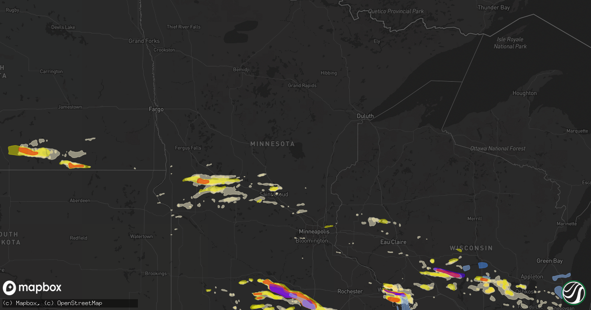
Hail Map in Minnesota on June 2, 2020
Get this storm
June 2 map
$229
one time, instant access
Download today. No call, no setup
Keep the $229
Bought the map and want the full workflow? Apply the entire $229 to a subscription within 7 days. None of it is wasted.
Every map, not just this one
This buys you this map. Subscription and you get every map we run, in the markets you choose from a few cities to whole states to nationwide. Plus real-time alerts the moment a storm fires.
Contact data
Name, contact info, occupancy, even credit band for addresses in the footprint. You go from where it hit to who to call.
Become the source they trust
Unlimited branding weather history reports on demand. You already have the documented answer ready for the property owner, and you are the one who showed up with it.
Property data and RoofTrace estimates
Pull up any address you have got, its value and the exact code rules for that jurisdiction, straight from One Click Code. Then RoofTrace estimates the squares, pitch, and roof value, priced the way you price.
Storm reports in Minnesota
Minnesota
| Date | Description |
|---|---|
| 06/02/20206:53 PM CDT | Delayed report - large tree blown down... Time estimated from radar. |
| 06/02/20206:40 PM CDT | 3 trees fell onto a house. |
| 06/02/20206:40 PM CDT | Power lines down. |
| 06/02/20206:36 PM CDT | A local report indicates 1.75 inch wind near DAKOTA |
| 06/02/20206:35 PM CDT | Photo shared on twitter of a large tree down. |
| 06/02/20206:30 PM CDT | Damage to side and roof of home. Reported via twitter. Photos included. Time estimated. |
| 06/02/20206:25 PM CDT | Large tree down. Reported via twitter. Photo included. Time estimated. |
| 06/02/20206:25 PM CDT | 55kt wind gust reported by the asos. |
| 06/02/20206:15 PM CDT | Church steeple blown over... Time estimated from radar. |
| 06/02/20206:07 PM CDT | Delayed report - tree branches also down across town. Time estimated from radar. |
| 06/02/20206:00 PM CDT | Measured with davis instrument. Reported via twitter. Time estimated. |
| 06/02/20206:00 PM CDT | Large tree down at intersection of 105th and 120th two miles nw of new richland. Reported via twitter. Photo included. Time estimated. |
| 06/02/20205:50 PM CDT | Report of downed tree branches across the road. Some larger than 12 inch in diameter. |
| 06/02/20205:50 PM CDT | Reported via twitter as slightly larger than a golf ball. Photo included. Time estimated. |
| 06/02/20205:50 PM CDT | A local report indicates 1.00 inch wind near 2 S PEMBERTON |
| 06/02/20205:45 PM CDT | Relayed via social media. Time estimated from radar. |
| 06/02/20205:45 PM CDT | A local report indicates a tornado near 4 W WALDORF |
| 06/02/20205:43 PM CDT | Relayed via em. |
| 06/02/20205:40 PM CDT | A local report indicates 1.75 inch wind near 1 S WINONA |
| 06/02/20205:36 PM CDT | . |
| 06/02/20205:32 PM CDT | A local report indicates 1.25 inch wind near 1 E WINONA |
| 06/02/20205:30 PM CDT | Via social media. |
| 06/02/20205:30 PM CDT | Delayed report - 1 tree down on property... Time estimated from radar. |
| 06/02/20205:29 PM CDT | Delayed report... Time estimated from radar. |
| 06/02/20205:27 PM CDT | A local report indicates a tornado near 5 N MAPLETON |
| 06/02/20205:20 PM CDT | Relayed via phone. |
| 06/02/20205:20 PM CDT | Relayed via social media. Time estimated from radar. |
| 06/02/20205:20 PM CDT | Relayed via social media. Time estimated from radar. |
| 06/02/20205:20 PM CDT | A local report indicates 1.00 inch wind near 1 WNW SKYLINE |
| 06/02/20205:17 PM CDT | A local report indicates 1.75 inch wind near WINONA |
| 06/02/20205:15 PM CDT | . |
| 06/02/20205:15 PM CDT | A local report indicates 1.00 inch wind near 1 S GOODVIEW |
| 06/02/20205:09 PM CDT | Delayed report from trained spotter. Noted hail damage to vegetation. |
| 06/02/20205:07 PM CDT | Multiple reports of a tornado occurring northeast of garden city. |
| 06/02/20205:00 PM CDT | A local report indicates 2.00 inch wind near 2 ENE LAKE CRYSTAL |
| 06/02/20204:55 PM CDT | Quarter sized hail reported via twitter. Photo included. Time estimated. |
| 06/02/20204:52 PM CDT | A local report indicates 1.00 inch wind near 1 E MAHTOMEDI |
| 06/02/20204:30 PM CDT | A local report indicates 1.25 inch wind near 4 ESE HANSKA |
| 06/02/20204:30 PM CDT | A local report indicates 1.00 inch wind near 5 WNW LAKE CRYSTAL |
| 06/02/20202:57 PM CDT | A local report indicates 1.00 inch wind near COLD SPRING |
| 06/02/20202:40 PM CDT | A local report indicates 1.25 inch wind near SAUK RAPIDS |
| 06/02/20202:30 PM CDT | A local report indicates 1.00 inch wind near SARTELL |
| 06/02/20201:40 PM CDT | Photo via twitter. |
| 06/02/20201:22 PM CDT | A local report indicates 1.00 inch wind near VILLARD |
| 06/02/202012:49 PM CDT | Estimated hail size by fire dept. |
| 06/02/202012:15 PM CDT | Hail fell at the white horse ranch for 5 to 10 min ranging in size from pea to quarter. |
| 06/02/20207:09 AM CDT | At 1208 PM CDT, a severe thunderstorm was located near Herman, or 33 miles south of Fergus Falls, moving east at 45 mph. HAZARD...60 mph wind gusts and quarter size hail. SOURCE...Radar indicated. IMPACT...Hail damage to vehicles is expected. Expect wind damage to roofs, siding, and trees. Locations impacted include... Hoffman, Herman and Barrett. |
| 06/02/20202:07 AM CDT | At 706 PM CDT, severe thunderstorms were located along a line extending from La Farge to near Lansing to 6 miles southeast of Mabel, moving southeast at 45 mph. HAZARD...60 mph wind gusts and quarter size hail. SOURCE...Radar indicated. IMPACT...Hail damage to vehicles is expected. Expect wind damage to roofs, siding, and trees. Severe thunderstorms will be near... Lansing around 710 PM CDT. Waukon and Harpers Ferry around 725 PM CDT. Postville around 740 PM CDT.Other locations impacted by these severe thunderstorms includeVolney, County Roads A 52 And W 60, Eastman, Horrigan Ridge,Quandahl, Watson and Red Barn Campground. |
| 06/02/20201:55 AM CDT | At 654 PM CDT, severe thunderstorms were located along a line extending from Austin to near London to near Emmons, moving east at 35 mph. HAZARD...Ping pong ball size hail and 60 mph wind gusts. SOURCE...Radar indicated. IMPACT...People and animals outdoors will be injured. Expect hail damage to roofs, siding, windows, and vehicles. Expect wind damage to roofs, siding, and trees. Severe thunderstorms will be near... Rose Creek around 720 PM CDT. Adams around 725 PM CDT. St. Ansgar and Lyle around 730 PM CDT. Stacyville around 745 PM CDT. Le Roy around 805 PM CDT.Other locations impacted by these severe thunderstorms include CountyRoads A 39 And S 70, Meyer, Toeterville, Otranto, Brownville, CountyRoads T 54 And A 31 and County Roads 4 And 8. |
| 06/02/20201:33 AM CDT | At 633 PM CDT, outflow from severe thunderstorms was located along a line extending from near Lyle to 7 miles south of Frost, moving southeast at 30 mph. HAZARD...60 mph wind gusts. SOURCE...Observed. IMPACT...Expect damage to roofs, siding, and trees. Locations impacted include... Forest City, Northwood, Lake Mills, Manly, Emmons, Rice Lake, Buffalo Center, Thompson, Plymouth, Fertile, Leland, Kensett, Grafton, Hanlontown, Rake, Joice, Scarville, Bolan, Lake Mills Municipal Airport and Hogsback Wildlife Area.This includes Interstate 35 between mile markers 203 and 218. |
| 06/02/20201:32 AM CDT | At 631 PM CDT, a severe thunderstorm was located over Twin Lakes, or 8 miles south of Albert Lea, moving east at 35 mph. HAZARD...60 mph wind gusts and quarter size hail. SOURCE...Trained weather spotters. IMPACT...Hail damage to vehicles is expected. Expect wind damage to roofs, siding, and trees. Locations impacted include... Albert Lea, Alden, Glenville, Emmons, Bricelyn, London, Hayward, Mansfield, Twin Lakes, Conger, Kiester and Walters.This includes the following highways... Interstate 35 between mile markers 1 and 12. Interstate 90 between mile markers 135 and 154, and between milemarkers 161 and 173. |
| 06/02/20201:31 AM CDT | At 630 PM CDT, a severe thunderstorm was located near Blooming Prairie, or 14 miles south of Owatonna, moving east at 35 mph. HAZARD...Tennis ball size hail and 70 mph wind gusts. This storm has a history of producing large hail and damaging winds. SOURCE...Trained weather spotters. IMPACT...People and animals outdoors will be injured. Expect hail damage to roofs, siding, windows, and vehicles. Expect considerable tree damage. Wind damage is also likely to mobile homes, roofs, and outbuildings. This severe thunderstorm will be near... Blooming Prairie around 640 PM CDT. Hayfield around 655 PM CDT. Rochester and Stewartville around 725 PM CDT.Other locations impacted by this severe thunderstorm include CountyRoads 3 And 108, County Roads 6 And 15, Salem Corners, Rock Dell,Brookside Campground, County Roads 5 And 6 and Mayville. |
| 06/02/20201:19 AM CDT | At 619 PM CDT, severe thunderstorms were located along a line extending from near Amboy to Iowa Lake, moving east at 55 mph. HAZARD...60 mph wind gusts and quarter size hail. SOURCE...Radar indicated. IMPACT...Hail damage to vehicles is expected. Expect wind damage to roofs, siding, and trees. Locations impacted include... Fairmont, Blue Earth, Winnebago, Truman, Minnesota Lake, Welcome, Elmore, Ceylon, Easton, Frost, Delavan and Granada.This includes the following highways... Interstate 90 between mile markers 94 and 135. U.S. Highway 169 between mile markers 1 and 25. |
| 06/02/20201:18 AM CDT | At 618 PM CDT, a severe thunderstorm was located near New Richland, or 14 miles north of Albert Lea, moving east at 25 mph. HAZARD...Tennis ball size hail and 60 mph wind gusts. SOURCE...Radar indicated. IMPACT...People and animals outdoors will be injured. Expect hail damage to roofs, siding, windows, and vehicles. Expect wind damage to roofs, siding, and trees. Locations impacted include... Albert Lea, Wells, Blooming Prairie, New Richland, Clarks Grove, Ellendale, Alden, Geneva, Hartland, Hollandale, Freeborn and Hayward.This includes the following highways... Interstate 35 between mile markers 11 and 34. Interstate 90 between mile markers 149 and 173. U.S. Highway 14 near mile marker 157. |
| 06/02/20201:14 AM CDT | At 613 PM CDT, outflow from thunderstorms were located along a line extending from 9 miles southeast of Iowa Lake to near Terril, moving southeast at 25 mph. HAZARD...70 mph wind gusts. SOURCE...Observed. IMPACT...Expect considerable tree damage. Damage is likely to mobile homes, roofs, and outbuildings. Locations impacted include... Estherville, Emmetsburg, Swan Lake, Five Island Lake, Ingham Lake, High Lake, Lost Island Lake, Okamanpedan Lake, Iowa Lake, Union Slogh, Armstrong, Graettinger, Ruthven, Bancroft, Swea City, Ringsted, Fenton, Lakota, Wallingford and Lone Rock. |
| 06/02/20201:07 AM CDT | At 607 PM CDT, a severe thunderstorm was located over Ocheyedan, or 8 miles east of Sibley, moving east at 20 mph. HAZARD...60 mph wind gusts and quarter size hail. SOURCE...Radar indicated. IMPACT...Hail damage to vehicles is expected. Expect wind damage to roofs, siding, and trees. This severe thunderstorm will be near... Harris around 630 PM CDT. |
| 06/02/202012:58 AM CDT | At 558 PM CDT, a severe thunderstorm was located over Holmen, or 10 miles north of La Crescent, moving east at 30 mph. HAZARD...60 mph wind gusts and quarter size hail. SOURCE...Radar indicated. IMPACT...Hail damage to vehicles is expected. Expect wind damage to roofs, siding, and trees. This severe thunderstorm will be near... La Crosse and Onalaska around 605 PM CDT. West Salem around 620 PM CDT. Bangor around 630 PM CDT.Other locations impacted by this severe thunderstorm includeStevenstown, I 90 Exit 4, I 90 Exit 5, County Roads D E And E, BlueBird Campground, I 90 Exit 12 and Severson Coulee. |
| 06/02/202012:42 AM CDT | At 542 PM CDT, severe thunderstorms were located along a line extending from near Lake Crystal to near Trimont, moving east at 45 mph. HAZARD...Golf ball size hail and 60 mph wind gusts. SOURCE...Radar indicated. IMPACT...People and animals outdoors will be injured. Expect hail damage to roofs, siding, windows, and vehicles. Expect wind damage to roofs, siding, and trees. Locations impacted include... Fairmont, Blue Earth, Mapleton, Winnebago, Truman, Minnesota Lake, Amboy, Vernon Center, Lewisville, Easton, Delavan and Granada.This includes the following highways... Interstate 90 between mile markers 96 and 134. U.S. Highway 169 between mile markers 11 and 38. |
| 06/02/202012:18 AM CDT | At 518 PM CDT, a severe thunderstorm was located near Trempealeau, or near Winona, moving east at 25 mph. HAZARD...Two inch hail and 60 mph wind gusts. SOURCE...Radar indicated. IMPACT...People and animals outdoors will be injured. Expect hail damage to roofs, siding, windows, and vehicles. Expect wind damage to roofs, siding, and trees. This severe thunderstorm will be near... Trempealeau around 530 PM CDT. Dakota around 540 PM CDT. Brice Prairie around 545 PM CDT. Onalaska, Holmen and La Crosse Airport around 555 PM CDT. La Crosse and French Island around 600 PM CDT.Other locations impacted by this severe thunderstorm include PerrotState Park, Marshland, I 90 Exit 275, Pickwick, I 90 Exit 2, I 90Exit 266 and I 90 Exit 272. |
| 06/02/202012:14 AM CDT | At 514 PM CDT, a severe thunderstorm was located near Lewisville, or 22 miles north of Fairmont, moving southeast at 30 mph. HAZARD...Two inch hail and 60 mph wind gusts. SOURCE...Radar indicated. IMPACT...People and animals outdoors will be injured. Expect hail damage to roofs, siding, windows, and vehicles. Expect wind damage to roofs, siding, and trees. Locations impacted include... St. James, Truman, Amboy, Lewisville, St James Airport and Grogan. This includes U.S. Highway 169 between mile markers 26 and 33. |
| 06/01/202011:48 PM CDT | At 448 PM CDT, a severe thunderstorm was located near Lake Crystal, or 8 miles southwest of Mankato, moving east at 20 mph. HAZARD...Two inch hail and 60 mph wind gusts. SOURCE...Radar indicated. IMPACT...People and animals outdoors will be injured. Expect hail damage to roofs, siding, windows, and vehicles. Expect wind damage to roofs, siding, and trees. Locations impacted include... Mankato, North Mankato, Lake Crystal, Eagle Lake, Nicollet, St. Clair, Good Thunder, Vernon Center, Pemberton, Garden City, Judson and Skyline.This includes the following highways... U.S. Highway 14 between mile markers 116 and 143. U.S. Highway 169 between mile markers 35 and 58. |
| 06/01/202011:37 PM CDT | At 437 PM CDT, a severe thunderstorm was located over Dovray, or 8 miles east of Slayton, moving east at 30 mph. HAZARD...60 mph wind gusts and quarter size hail. SOURCE...Radar indicated. IMPACT...Hail damage to vehicles is expected. Expect wind damage to roofs, siding, and trees. This severe thunderstorm will be near... Westbrook around 455 PM CDT. Storden around 505 PM CDT. Jeffers around 515 PM CDT.Other locations impacted by this severe thunderstorm include Delftand Avoca. |
| 06/01/202011:23 PM CDT | At 423 PM CDT, a severe thunderstorm was located near Hanska, or 10 miles southeast of New Ulm, moving east at 30 mph. HAZARD...60 mph wind gusts and quarter size hail. SOURCE...Radar indicated. IMPACT...Hail damage to vehicles is expected. Expect wind damage to roofs, siding, and trees. Locations impacted include... Sleepy Eye, Courtland, Hanska, Comfrey and Searles. This includes U.S. Highway 14 between mile markers 84 and 87, andbetween mile markers 109 and 115. |
| 06/01/20208:10 PM CDT | . |
| 06/01/20207:15 PM CDT | Awos station kael albert lea ap. |
| 06/01/20207:05 PM CDT | Numerous trees and limbs reported down across western mower county from earlier storms. Also an overturned semi north of austin. Time estimated from radar. |
| 06/01/20207:05 PM CDT | Semi overturned on freeborn co rd 2. |
All States Impacted by Hail Map on June 2, 2020
Cities Impacted by Hail Map on June 2, 2020
- Malone, WI
- Saint Cloud, WI
- Primghar, IA
- Sutherland, IA
- Minburn, IA
- Adel, IA
- Saint Francis, KS
- Dexter, IA
- Stuart, IA
- Ashley, ND
- Ellendale, ND
- Forbes, ND
- Republican City, NE
- Alma, NE
- Comfrey, MN
- Hollandale, MN
- Albert Lea, MN
- Hornick, IA
- Mapleton, IA
- Castana, IA
- Danbury, IA
- Rodney, IA
- Dallas Center, IA
- Grimes, IA
- Waukee, IA
- Fontanelle, IA
- Greenfield, IA
- Dakota, MN
- La Crescent, MN
- Houston, MN
- Belding, MI
- Pittsville, WI
- Babcock, WI
- Burlington, CO
- Alexandria, MN
- Shannon City, IA
- Afton, IA
- Creston, IA
- Winterset, IA
- Spring Mills, PA
- Centre Hall, PA
- Foley, MN
- Sauk Rapids, MN
- Scottsville, NY
- Churchville, NY
- Wishek, ND
- Torrington, WY
- Clear Lake, WI
- Stoddard, WI
- Baxter, IA
- Tipton, IA
- Bennett, IA
- Wilton, IA
- New Liberty, IA
- Stockton, IA
- Walcott, IA
- West Branch, IA
- Wild Rose, WI
- Almond, WI
- Plainfield, WI
- Winona, MN
- Trumansburg, NY
- Interlaken, NY
- Penn Yan, NY
- Himrod, NY
- Lodi, NY
- Friendship, WI
- Armstrong, IA
- Whiting, IA
- Onawa, IA
- Starbuck, MN
- Glenwood, MN
- Villard, MN
- Hildreth, NE
- East Concord, NY
- Osseo, WI
- Cold Spring, MN
- Saint Cloud, MN
- Richmond, MN
- Sleepy Eye, MN
- New Ulm, MN
- Hanska, MN
- Machias, NY
- West Valley, NY
- Maxwell, NE
- North Platte, NE
- Wellfleet, NE
- Maywood, NE
- Guernsey, WY
- Yoder, WY
- Jay Em, WY
- Fort Laramie, WY
- Ellicottville, NY
- Greenville, MI
- Colo, IA
- Collins, IA
- Rhodes, IA
- State Center, IA
- Melbourne, IA
- Blue Earth, MN
- Pine River, WI
- Dansville, NY
- Springwater, NY
- Conesus, NY
- Holbrook, NE
- Round Lake, MN
- West Falls, NY
- Colden, NY
- Palisade, NE
- Wauneta, NE
- Stratton, NE
- Trenton, NE
- Saint James, MN
- Lewisville, MN
- Herman, MN
- Garden City, MN
- Cedar Grove, WI
- Waucoma, IA
- Lawler, IA
- Fort Atkinson, IA
- Grand Rapids, MI
- Delevan, NY
- Glenwood, NY
- Chaffee, NY
- East Otto, NY
- Boston, NY
- Springville, NY
- Holland, NY
- Enders, NE
- Imperial, NE
- Champion, NE
- Stamford, NE
- Orleans, NE
- Belgrade, MN
- Brooten, MN
- Black River Falls, WI
- Tomah, WI
- Sparta, WI
- Warrens, WI
- Belle Fourche, SD
- Anoka, MN
- Elk River, MN
- Kanorado, KS
- Wray, CO
- Goodland, KS
- Bird City, KS
- Sauk Centre, MN
- Madison, MN
- Marietta, MN
- Redgranite, WI
- Hancock, WI
- Berlin, WI
- Omro, WI
- Ripon, WI
- Wautoma, WI
- Poy Sippi, WI
- Fremont, WI
- Rice, MN
- Sheboygan, WI
- Veteran, WY
- Lingle, WY
- Naponee, NE
- Earlham, IA
- Peru, IA
- Macksburg, IA
- Lorimor, IA
- Tonawanda, NY
- Buffalo, NY
- Atalissa, IA
- Max, NE
- Cheyenne, WY
- Mapleton, MN
- Pemberton, MN
- Holmen, WI
- Onalaska, WI
- Byron, NY
- Linwood, NY
- Le Roy, NY
- Caledonia, NY
- Bergen, NY
- Piffard, NY
- Fredonia, ND
- Lancaster, WI
- Lehr, ND
- Osakis, MN
- Sartell, MN
- Holley, NY
- Brockport, NY
- North Tonawanda, NY
- Sanborn, NY
- Niagara Falls, NY
- Saint Joseph, MN
- Coggon, IA
- Galesville, WI
- Fountain City, WI
- Trempealeau, WI
- Dodge, WI
- Ransomville, NY
- Lewiston, NY
- Grand Island, NY
- West Salem, WI
- Alden, MN
- Farmersburg, IA
- Luana, IA
- Ossian, IA
- Castalia, IA
- Monona, IA
- McGregor, IA
- West Union, IA
- Clermont, IA
- Postville, IA
- Correctionville, IA
- Cushing, IA
- Corning, IA
- Nodaway, IA
- Lidgerwood, ND
- Delavan, MN
- Easton, MN
- Wells, MN
- Welcome, MN
- Fairmont, MN
- Truman, MN
- Trimont, MN
- Orchard Park, NY
- Freeport, MN
- Fond Du Lac, WI
- Elkhart Lake, WI
- Mount Calvary, WI
- Hancock, MN
- Morris, MN
- Oxford, NE
- Hayes Center, NE
- Benkelman, NE
- Princeton, IA
- Le Claire, IA
- Farwell, MN
- La Crosse, WI
- Delhi, IA
- Prole, IA
- Patterson, IA
- Windom, MN
- Springfield, MN
- Good Thunder, MN
- Vernon Center, MN
- Madelia, MN
- Amboy, MN
- Excelsior, MN
- Chanhassen, MN
- Chilton, WI
- Elwood, NE
- Bloomington, NE
- Milbank, SD
- Revillo, SD
- Eldridge, IA
- Long Grove, IA
- Broadus, MT
- Greenwood, WI
- Thorp, WI
- Mankato, MN
- Lake Crystal, MN
- Neillsville, WI
- Merrillan, WI
- Neshkoro, WI
- Grover, CO
- Kimball, MN
- Clearwater, MN
- Prescott, IA
- Holstein, NE
- Hamburg, NY
- Lowry, MN
- Kensington, MN
- Little Falls, MN
- Bowlus, MN
- Royalton, MN
- Orient, IA
- Avon, MN
- Montello, WI
- Princeton, WI
- Paris, MI
- Murdock, MN
- Custer, MI
- Ludington, MI
- Baldwin, MI
- Branch, MI
- Scottville, MI
- Riceville, IA
- Elma, IA
- Loomis, NE
- Geneva, MN
- Hayward, MN
- Janesville, MN
- Ellendale, MN
- Minnesota Lake, MN
- Waldorf, MN
- Austin, MN
- Clarks Grove, MN
- Dexter, MN
- Brownsdale, MN
- Rose Creek, MN
- Hartland, MN
- Waseca, MN
- New Richland, MN
- Culbertson, NE
- Lagrange, WY
- Meriden, WY
- Nekoosa, WI
- Funk, NE
- Holdrege, NE
- Diagonal, IA
- Laurel, IA
- Beaver City, NE
- Olean, NY
- Allegany, NY
- Wayland, NY
- Brady, NE
- Moorefield, NE
- Newton, WI
- Cleveland, WI
- Mondovi, WI
- Eleva, WI
- Hoffman, MN
- Boyceville, WI
- Lyman, NE
- Hawk Springs, WY
- Saint Stephen, MN
- Holdingford, MN
- Albany, MN
- Westbrook, MN
- Port Allegany, PA
- Eldred, PA
- Smethport, PA
- Crosby, PA
- Geneseo, NY
- Avon, NY
- Briggsdale, CO
- Coloma, WI
- Oshkosh, WI
- Winneconne, WI
- Butte Des Morts, WI
- Solon, IA
- North Liberty, IA
- Benton, IA
- Somerset, WI
- Stillwater, MN
- Orchard, IA
- Osage, IA
- Edgeley, ND
- Eden Prairie, MN
- Beldenville, WI
- Saint Onge, SD
- Smithland, IA
- Oto, IA
- Swisher, IA
- Kulm, ND
- Paynesville, MN
- Melrose, MN
- Ocheyedan, IA
- Youngstown, NY
- Wisconsin Rapids, WI
- Necedah, WI
- Jackson, MN
- Arpin, WI
- Van Tassell, WY
- Lusk, WY
- Harrison, NE
- Wilmot, SD
- Clinton, MN
- Grafton, IA
- Central City, IA
- Anamosa, IA
- Ryan, IA
- Morrill, NE
- Urbandale, IA
- Napoleon, ND
- Bath, NY
- Rixford, PA
- Duke Center, PA
- Storden, MN
- Jeffers, MN
- Arkdale, WI
- Waupaca, WI
- Bancroft, WI
- Pickett, WI
- Van Dyne, WI
- Elsie, NE
- Elberon, IA
- Keystone, IA
- Kill Buck, NY
- Limestone, NY
- Great Valley, NY
- Markesan, WI
- Green Lake, WI
- Stanwood, IA
- Clarence, IA
- Bertrand, NE
- Ithaca, NY
- West Bend, WI
- Kewaskum, WI
- Fredonia, WI
- Manly, IA
- Kensett, IA
- Linwood, MI
- Pinconning, MI
- Murray, IA
- Bloomer, WI
- Victoria, MN
- Claire City, SD
- Prattsburgh, NY
- Avoca, NY
- Center Point, IA
- Niagara University, NY
- Meriden, IA
- Cleghorn, IA
- Cuba City, WI
- Hazel Green, WI
- Sibley, IA
- Paullina, IA
- Larrabee, IA
- Barrett, MN
- Granada, MN
- Lakefield, MN
- Edison, NE
- Arapahoe, NE
- Ridgeland, WI
- Wheeler, WI
- Northwood, IA
- Erie, PA
- Appleton, MN
- Blooming Prairie, MN
- Dalbo, MN
- Welch, MN
- Melrose, WI
- Hastings, MN
- Franklinville, NY
- Winnebago, MN
- Lenox, IA
- Vesper, WI
- Currie, MN
- Avoca, MN
- Eldorado, WI
- Rosendale, WI
- McCook, NE
- Forest City, IA
- Mechanicsville, IA
- Martelle, IA
- Lisbon, IA
- Bethune, CO
- Clear Lake, MN
- Monticello, MN
- Sunburg, MN
- Garrison, IA
- Vinton, IA
- Port Byron, IL
- Cordova, IL
- Humbird, WI
- Sardinia, NY
- Glenville, MN
- Mount Ayr, IA
- Blockton, IA
- Bedford, IA
- Clearfield, IA
- Thayer, IA
- Tingley, IA
- Lyle, MN
- Bingham Lake, MN
- Hartville, WY
- North East, PA
- Cambridge Springs, PA
- Venango, PA
- Strum, WI
- Mindoro, WI
- Stanley, WI
- Clear Lake, IA
- Ortonville, MN
- Middlesex, NY
- Rushville, NY
- Hector, NY
- Plymouth, WI
- Sheboygan Falls, WI
- Sherburn, MN
- Theresa, WI
- Lomira, WI
- Arcadia, WI
- Alpha, MN
- Calamus, IA
- Dixon, IA
- Oakes, ND
- Waldo, WI
- Elma, NY
- Depew, NY
- Lancaster, NY
- Lansing, MN
- Elkton, MN
- Belgium, WI
- Selfridge, ND
- Becker, MN
- Rush, NY
- Elba, NY
- Mumford, NY
- Albion, NY
- Blair, WI
- Iowa City, IA
- Durant, IA
- Coralville, IA
- Wheatland, IA
- Tiffin, IA
- Cedar Rapids, IA
- Fairfax, IA
- Oxford, IA
- Alzada, MT
- Clutier, IA
- Valders, WI
- Saint Nazianz, WI
- Kiel, WI
- Camp Douglas, WI
- Hopkinton, IA
- Manchester, IA
- Spring Valley, WI
- Hilbert, WI
- Bricelyn, MN
- Ledyard, IA
- Bitely, MI
- New Boston, IL
- Chokio, MN
- Rochester, MI
- Plainview, MN
- Altura, MN
- Lake View, NY
- Lawtons, NY
- Salamanca, NY
- Derrick City, PA
- Eden, NY
- Joy, IL
- Glenwood City, WI
- Downing, WI
- Campbellsport, WI
- New Hampton, IA
- Alta Vista, IA
- Sisseton, SD
- Correll, MN
- Holloway, MN
- Brandon, MN
- Evansville, MN
- Chester, IA
- Pewamo, MI
- Mountain Lake, MN
- Ashton, IA
- Zimmerman, MN
- Maxwell, IA
- Austin, PA
- Roulette, PA
- Emmons, MN
- Twin Lakes, MN
- Danvers, MN
- Lake Park, IA
- Spirit Lake, IA
- Reinbeck, IA
- Ceylon, MN
- Dolliver, IA
- Odessa, MN
- Bellingham, MN
- New Prague, MN
- Chippewa Falls, WI
- Jim Falls, WI
- Neenah, WI
- Adams, MN
- Colfax, WI
- New Auburn, WI
- Ettrick, WI
- McIntire, IA
- Stacyville, IA
- Saint Ansgar, IA
- Cyrus, MN
- Garnavillo, IA
- Fe Warren Afb, WY
- Grey Eagle, MN
- Benson, MN
- Tintah, MN
- Beardsley, MN
- Lamoure, ND
- Verona, ND
- Lu Verne, IA
- Comstock Park, MI
- Elk Mound, WI
- Savage, MN
- Prior Lake, MN
- Graceville, MN
- Coon Valley, WI
- Bangor, WI
- Worthington, MN
- Rockford, MI
- Fullerton, ND
- Elrosa, MN
- Donnelly, MN
- Amherst, WI
- Minden, NE
- Marshfield, WI
- Donahue, IA
- Bradford, PA
- Collins, NY
- Turtlepoint, PA
- Black Creek, NY
- Getzville, NY
- Freedom, NY
- Caneadea, NY
- North Collins, NY
- Little Valley, NY
- Cuba, NY
- Hinsdale, NY
- Gowanda, NY
- Cattaraugus, NY
- Belfast, NY
- Gifford, PA
- Emporium, PA
- Decorah, IA
- Ridgeway, IA
- Brandon, WI
- Langworthy, IA
- Monticello, IA
- Onslow, IA
- Joice, IA
- Wheaton, MN
- Elmore, MN
- Prairie Farm, WI
- Big Stone City, SD
- Oakfield, WI
- Brownsville, WI
- Van Meter, IA
- Veblen, SD
- Coudersport, PA
- Algona, IA
- Bode, IA
- Marshalltown, IA
- Peever, SD
- West Union, MN
- Saint Clair, MN
- Willernie, MN
- Saint Paul, MN
- Minnesota City, MN
- Lemmon, SD
- Hettinger, ND
- Eustis, NE
- Auburndale, WI
- Weyauwega, WI
- Endeavor, WI
- Hokah, MN
- Caledonia, MN
- New Lothrop, MI
- Lennon, MI
- Vernon, MI
- Owosso, MI
- Elsie, MI
- Oakley, MI
- Swartz Creek, MI
- Bannister, MI
- Chesaning, MI
- Ovid, MI
- Gaines, MI
- Corunna, MI
- Durand, MI
- Henderson, MI
- Portville, NY
- Ulysses, PA
- Alma, NY
- Wellsville, NY
- Little Genesee, NY
- Bolivar, NY
- Shinglehouse, PA
- Friendship, NY
- Genesee, PA
- Dresden, NY
- Ovid, NY
- East Aurora, NY
- North Chili, NY
- Lima, NY
- Honeoye Falls, NY
- Kintyre, ND
- Zeeland, ND
- Strasburg, ND
- Linton, ND
- Hague, ND
- Battle Creek, IA
- Port Edwards, WI
- Rudolph, WI
- Stevens Point, WI
- Plover, WI
- Genoa, WI
- Chaseburg, WI
- Brownsville, MN
- Greenleaf, WI
- Whitelaw, WI
- Maribel, WI
- Mishicot, WI
- Two Rivers, WI
- Reedsville, WI
- Manitowoc, WI


