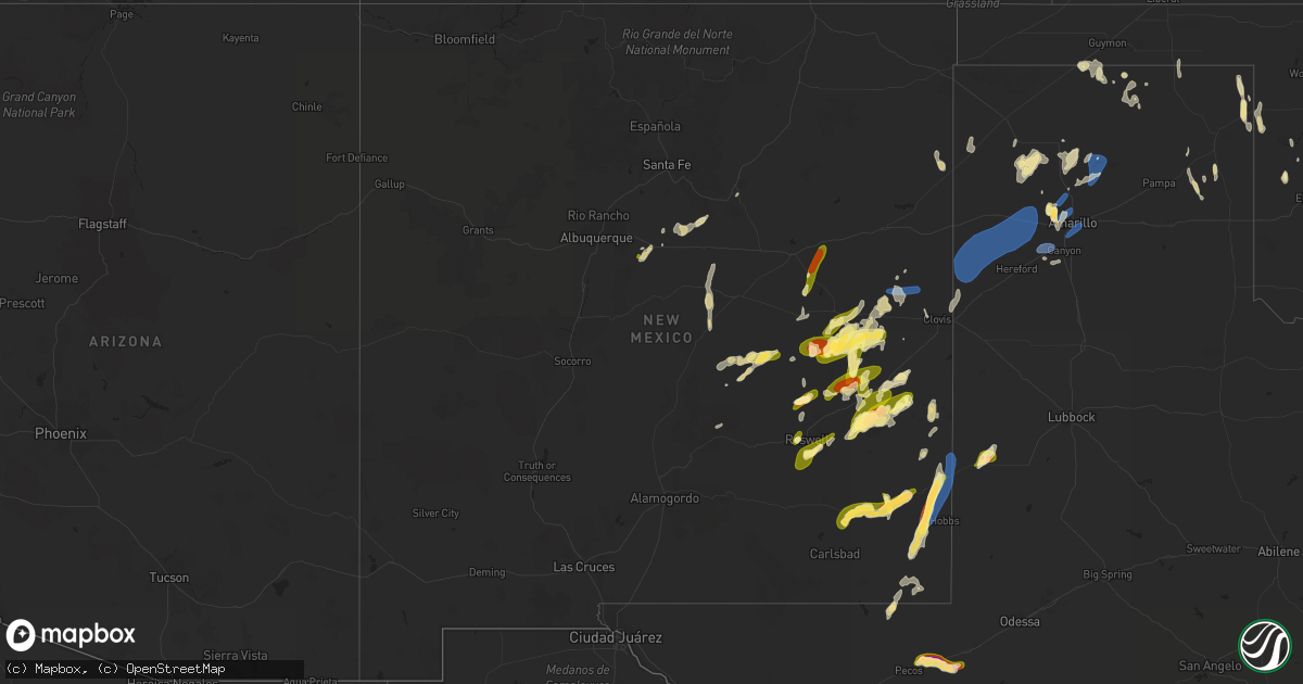
Hail Map in New Mexico on May 31, 2023
Get this storm
May 31 map
$229
one time, instant access
Download today. No call, no setup
Keep the $229
Bought the map and want the full workflow? Apply the entire $229 to a subscription within 7 days. None of it is wasted.
Every map, not just this one
This buys you this map. Subscription and you get every map we run, in the markets you choose from a few cities to whole states to nationwide. Plus real-time alerts the moment a storm fires.
Contact data
Name, contact info, occupancy, even credit band for addresses in the footprint. You go from where it hit to who to call.
Become the source they trust
Unlimited branding weather history reports on demand. You already have the documented answer ready for the property owner, and you are the one who showed up with it.
Property data and RoofTrace estimates
Pull up any address you have got, its value and the exact code rules for that jurisdiction, straight from One Click Code. Then RoofTrace estimates the squares, pitch, and roof value, priced the way you price.
Storm reports in New Mexico
New Mexico
| Date | Description |
|---|---|
| 05/31/20235:32 PM CDT | Lea county em reported barn flying into vehicle along highway 83 east of lovington. Exact location and time estimated by radar. |
| 05/31/20235:24 PM CDT | A local report indicates 1.00 inch wind near 2 N Chilili |
| 05/31/20235:22 PM CDT | Lea county em reports multiple downed power poles along arkansas junction and stiles rd south of lovington. Exact time estimated by radar. |
| 05/31/20235:19 PM CDT | A local report indicates 1.00 inch wind near 2 N Chilili |
| 05/31/20235:18 PM CDT | Lea county em reports multiple downed power poles along highway 18 in hobbs. Exact location and time estimated by radar. |
| 05/31/20235:12 PM CDT | A local report indicates 1.00 inch wind near 5 N Fort Sumner |
| 05/31/20235:10 PM CDT | Lea county em reports roof ripped off and downed powerline poles at hwy 62 and arkansas junction west of hobbs. Exact location and time estimated by radar. |
| 05/31/20234:42 PM CDT | Social media video of a tornado near the ghost town of lon... Nm along nm highway 247. Combination of radar and spotter reports show tornado likely lasted 5 to 10 more |
| 05/31/20234:30 PM CDT | Mesonet station fw9690 jal. |
| 05/31/20233:50 PM CDT | A local report indicates 1.00 inch wind near 2 E Midway |
| 05/31/20233:48 PM CDT | A local report indicates 1.25 inch wind near Dexter |
| 05/31/20233:41 PM CDT | Social media report of estimated quarter size hail on twitter at the roswell airport. |
| 05/30/20238:00 PM CDT | A local report indicates 1.50 inch wind near 20 SSE Mesa |
| 05/30/20237:48 PM CDT | A local report indicates 1.00 inch wind near 5 E Elida |
| 05/30/20237:47 PM CDT | A local report indicates 1.25 inch wind near 4 E Elida |
| 05/30/20237:12 PM CDT | Asos station kabq albuquerque intl sunport. Thunderstorm outflow producing a gap wind through the sandia/manzano mountains. |
All States Impacted by Hail Map on May 31, 2023
Cities Impacted by Hail Map on May 31, 2023
- Las Vegas, NM
- Clear Lake, SD
- Gary, SD
- Revillo, SD
- La Junta, CO
- McClave, CO
- Las Animas, CO
- Dexter, NM
- Roswell, NM
- Artesia, NM
- Custer, SD
- Denver, CO
- Thornton, CO
- Delafield, WI
- Commerce City, CO
- Brighton, CO
- Henderson, CO
- Westminster, CO
- Arvada, CO
- Fort Lupton, CO
- Broomfield, CO
- Elida, NM
- Maljamar, NM
- Darien, WI
- Delavan, WI
- Capitan, NM
- Hobbs, NM
- Fort Sumner, NM
- Taiban, NM
- Erie, CO
- Lovington, NM
- Corona, NM
- Frederick, CO
- Longmont, CO
- Firestone, CO
- Mead, CO
- Avalon, WI
- Edgewood, NM
- Tijeras, NM
- Hermosa, SD
- Santa Rosa, NM
- Platteville, CO
- Bruneau, ID
- Hydro, OK
- Lookeba, OK
- Hinton, OK
- King Hill, ID
- Cuervo, NM
- Denver City, TX
- Tatum, NM
- Plains, TX
- Pep, NM
- Nunn, CO
- Carr, CO
- Wellington, CO
- Fort Collins, CO
- Cheyenne, WY
- Barnesville, MN
- Long Prairie, MN
- Archer, IA
- Sheldon, IA
- Jordan Valley, OR
- Hartley, TX
- Channing, TX
- Wood Lake, MN
- Holly, CO
- Helenville, WI
- Sullivan, WI
- Douglas, OK
- Buffalo, WY
- Janesville, WI
- Clinton, WI
- Hasty, CO
- Astoria, SD
- Edinburgh, IN
- Franklin, IN
- Slayton, MN
- Chandler, MN
- Lake Wilson, MN
- Oconomowoc, WI
- Hospers, IA
- Glendive, MT
- Wabasso, MN
- Hinton, IA
- Lawton, IA
- Malone, WI
- Fond Du Lac, WI
- Abilene, KS
- Havre, MT
- Box Elder, MT
- Dalhart, TX
- Grass Range, MT
- Lewistown, MT
- Marietta, MN
- Madison, MN
- Canby, MN
- Cheraw, CO
- Jefferson, SD
- Marshall, MN
- Cottonwood, MN
- Rubicon, WI
- Hartford, WI
- Russell, MN
- Minneota, MN
- Lynd, MN
- Ghent, MN
- Irons, MI
- Waukesha, WI
- Yorkville, IL
- Strandburg, SD
- Goodwin, SD
- Glendale Heights, IL
- Wheaton, IL
- Carol Stream, IL
- White, SD
- Granite Falls, MN
- Echo, MN
- Maynard, MN
- Sacred Heart, MN
- Plano, IL
- Van Dyne, WI
- Okauchee, WI
- Dawson, MN
- Mentone, TX
- Junction City, KS
- Chapman, KS
- Great Falls, MT
- Dacono, CO
- De Pere, WI
- Ransom, IL
- Pewaukee, WI
- Meriden, KS
- Eunice, NM
- Lamar, CO
- Dousman, WI
- Hartland, WI
- Jal, NM
- Whiteland, IN
- Wiley, CO
- Eads, CO
- Benson, MN
- Elkhorn, WI
- Bison, OK
- Sheridan Lake, CO
- East Troy, WI
- Vanderbilt, MI
- Watertown, WI
- Starbuck, MN
- Lincoln, NM
- Hennessey, OK
- Vega, TX
- Boyd, MN
- Monee, IL
- Woodstock, IL
- Clara City, MN
- Haswell, CO
- Sergeant Bluff, IA
- Sioux City, IA
- Beaumont, TX
- Oelrichs, SD
- Kingsley, IA
- Remsen, IA
- Greenwood, IN
- Bargersville, IN
- Ixonia, WI
- Crawford, NE
- Brethren, MI
- Allenton, WI
- Mukwonago, WI
- Eagle, WI
- Wolverine, MI
- Iron Ridge, WI
- Neosho, WI
- Waynetown, IN
- North Prairie, WI
- Wales, WI
- Nashotah, WI
- Encino, NM
- Montevideo, MN
- Emington, IL
- Odell, IL
- Saunemin, IL
- Westfield, IA
- Lloyd, MT
- Chinook, MT
- Stanford, MT
- Denton, MT
- Milford, KS
- Jefferson, WI
- Deweyville, TX
- Texhoma, OK
- Manhattan, IL
- Peotone, IL
- Frankfort, IL
- Pyote, TX
- Barstow, TX
- Bliss, ID
- Scenic, SD
- Fairburn, SD
- Burns, WY
- Carpenter, WY
- Hereford, TX
- Friona, TX
- Adrian, TX
- Pine Bluffs, WY
- Buffalo Gap, SD
- Fort Morgan, CO
- Brush, CO
- Amarillo, TX
- Monahans, TX
- New Raymer, CO
- Wildorado, TX
- Bushnell, NE
- Canyon, TX
- Panhandle, TX
- Masterson, TX
- Fritch, TX
- Stinnett, TX
- Yeso, NM
- Kaukauna, WI
- Verndale, MN
- Tenstrike, MN
- Perry, KS
- Oskaloosa, KS
- Laporte, MN
- Bemidji, MN
- Flandreau, SD
- Gruver, TX
- Capitol, MT
- Ekalaka, MT
- Ribera, NM
- Harrison, NE
- Fairview, OK
- Syracuse, KS
- Brooks, MN
- Atlanta, KS
- Moorcroft, WY
- Nara Visa, NM
- Amistad, NM
- Johnson, KS
- Little Rock, IA
- Milnesand, NM
- Loma, MT
- Lame Deer, MT
- Ashland, MT
- Hammon, OK
- Lusk, WY
- Marshall, IL
- West Terre Haute, IN
- Lake George, MN
- Stanley, NM
- Sanborn, IA
- Ashton, IA
- Enterprise, AL
- Buna, TX
- Pine Ridge, SD
- Dumas, TX
- Spearman, TX
- Goodwell, OK
- Terre Haute, IN
- Merom, IN
- Fairbanks, IN
- Sullivan, IN
- Monon, IN
- Jonesboro, IN
- Fairmount, IN
- Osage, WY
- Newcastle, WY
- Lake View, IA
- Marion, IN
- Vona, CO
- Seibert, CO
- Moriarty, NM
- Kit Carson, CO
- Saint Xavier, MT
- Crow Agency, MT
- Waukomis, OK
- Crossroads, NM
- Richfield, KS
- Hope, KS
- Lodge Grass, MT
- Portales, NM
- Hawk Springs, WY
- Daleville, AL
- Chancellor, AL
- Plentywood, MT
- Riley, KS
- Tonganoxie, KS
- McLouth, KS
- Hillsboro, KS
- Buffalo, SD
- Tampa, KS
- Johnstown, CO
- Hudson, CO
- Birney, MT
- Albin, WY
- Turpin, OK
- Bovina, TX
- Texico, NM
- Wyola, MT
- Hines, MN
- Tyler, MN
- Onaga, KS
- Rolla, KS
- Leedey, OK
- Dover, OK
- Fairmont, OK
- Adrian, MN
- Farwell, TX
- Durham, KS
- Morgan City, LA
- Floyd, NM
- Melrose, NM
- Clovis, NM
- Big Falls, MN
- Higgins, TX
- Arnett, OK
- Follett, TX
- Miami, TX
- Taloga, OK
- Texhoma, TX
- Happy, TX
- Waldron, KS
- Minneola, KS
- Pampa, TX
- Sac City, IA
- Cheyenne, OK
- Grover, CO
- Brusett, MT
- Sayre, OK
- Canadian, TX
- Mitchell, NE
- Sunray, TX
- Mobeetie, TX
- Amorita, OK
- Perryton, TX
- Balko, OK
- Green Castle, MO
- Mcalister, NM


