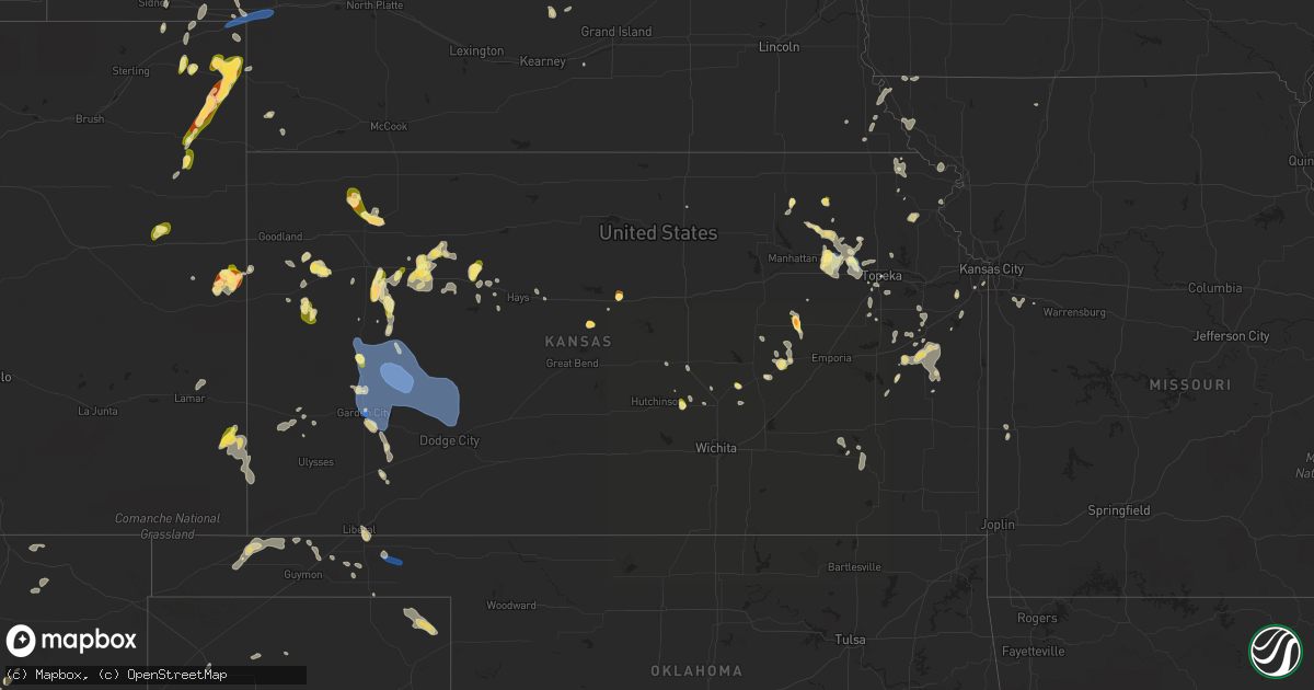
Hail Map in Kansas on May 30, 2023
Get this storm
May 30 map
$229
one time, instant access
Download today. No call, no setup
Keep the $229
Bought the map and want the full workflow? Apply the entire $229 to a subscription within 7 days. None of it is wasted.
Every map, not just this one
This buys you this map. Subscription and you get every map we run, in the markets you choose from a few cities to whole states to nationwide. Plus real-time alerts the moment a storm fires.
Contact data
Name, contact info, occupancy, even credit band for addresses in the footprint. You go from where it hit to who to call.
Become the source they trust
Unlimited branding weather history reports on demand. You already have the documented answer ready for the property owner, and you are the one who showed up with it.
Property data and RoofTrace estimates
Pull up any address you have got, its value and the exact code rules for that jurisdiction, straight from One Click Code. Then RoofTrace estimates the squares, pitch, and roof value, priced the way you price.
Storm reports in Kansas
Kansas
| Date | Description |
|---|---|
| 05/30/20236:40 PM CDT | A local report indicates 1.00 inch wind near 4 S PARK |
| 05/30/20236:07 PM CDT | Social media image of quarter size hail. |
| 05/30/20235:55 PM CDT | Delayed report via social media. Some ping pong ball to golf ball sized hail reported mixed in with smaller pea to quarter sized hail. Hail destroyed flower beds and ga |
| 05/30/20235:55 PM CDT | Hail was dime to half dollar size hail. Ground was 50 percent covered. |
| 05/30/20235:40 PM CDT | Courtesy of kwch. Time estimated by radar. |
| 05/30/20235:35 PM CDT | A local report indicates 1.25 inch wind near 7 NNW OGALLAH |
| 05/30/20235:15 PM CDT | A local report indicates 1.00 inch wind near 3 NE CEDAR POINT |
| 05/30/20234:45 PM CDT | A local report indicates 60 MPH wind near WILLARD |
| 05/30/20234:45 PM CDT | Delayed report. Time estimated from radar. 3-4 inch tree limb snapped. |
| 05/30/20234:43 PM CDT | Half inch diameter tree limbs down. |
| 05/30/20234:35 PM CDT | A local report indicates 60 MPH wind near 3 NNW DOVER |
| 05/30/20234:25 PM CDT | A local report indicates 60 MPH wind near 3 WSW SAINT MARYS |
| 05/30/20234:14 PM CDT | Social media report. |
| 05/30/20234:06 PM CDT | Delayed report. |
| 05/30/20234:05 PM CDT | A local report indicates 60 MPH wind near 1 N ROSSVILLE |
| 05/30/20233:43 PM CDT | A local report indicates 1.00 inch wind near PEABODY |
| 05/29/202310:41 PM CDT | Mesonet station ur350 4.4 ne hayne |
| 05/29/202310:22 PM CDT | Report from mping: 1-inch tree limbs broken; shingles blown off. |
| 05/29/202310:15 PM CDT | Mesonet station sauk1 satanta. |
| 05/29/20239:36 PM CDT | On grain elevator from kake. |
| 05/29/20239:31 PM CDT | On grain elevator from kake. |
| 05/29/20239:15 PM CDT | Mesonet station ks010 us-50 @ k-156 bridge garden city. |
| 05/29/20239:08 PM CDT | From kake. |
| 05/29/20239:03 PM CDT | Asos station kgck garden city. |
| 05/29/20238:32 PM CDT | Spotter reported about 200 yds visibility in blowing dirt. |
| 05/29/20238:32 PM CDT | Numerous 4 inch tree limbs downed. |
| 05/29/20238:30 PM CDT | Mesonet station dw2812 scott city. |
| 05/29/20238:26 PM CDT | Reported 55 to 70 mph winds. |
| 05/29/20238:26 PM CDT | A local report indicates 1.00 inch wind near 2 E SCOTT CITY |
| 05/29/20238:20 PM CDT | Mesonet station ew9720 scott city. |
| 05/29/20238:15 PM CDT | Awos station ktqk scott city. |
| 05/29/20237:50 PM CDT | Delayed/relayed report of ping pong ball sized hail and 1.9 inches total rain. Time estimated from radar. |
All States Impacted by Hail Map on May 30, 2023
Cities Impacted by Hail Map on May 30, 2023
- Spearfish, SD
- Beulah, WY
- Ord, NE
- North Loup, NE
- Fairmont, NE
- Martin, SD
- Lead, SD
- Bremen, KS
- Deadwood, SD
- Milligan, NE
- Valentine, NE
- Saint Libory, NE
- Rapid City, SD
- Home, KS
- Tuthill, SD
- Aurora, NE
- Vermillion, KS
- Ada, MN
- Gary, MN
- Fertile, MN
- Georgetown, MN
- Borup, MN
- Council Grove, KS
- Peabody, KS
- Winger, MN
- Belvue, KS
- Wamego, KS
- Rossville, KS
- Paxico, KS
- Saint Marys, KS
- Maple Hill, KS
- Silver Lake, KS
- Topeka, KS
- Elbow Lake, MN
- Hermosa, SD
- Caputa, SD
- Elmdale, KS
- Arapahoe, CO
- Burlington, CO
- Blackduck, MN
- Hines, MN
- Fosston, MN
- Lengby, MN
- Bagley, MN
- Northome, MN
- Kelliher, MN
- Wakeeney, KS
- Ogallah, KS
- Morland, KS
- Cottonwood Falls, KS
- Burrton, KS
- Ottertail, MN
- Perham, MN
- New York Mills, MN
- Winona, KS
- Rexford, KS
- Colby, KS
- Ellis, KS
- Palco, KS
- Aladdin, WY
- Ragley, LA
- Laurens, IA
- Westboro, MO
- Rock Port, MO
- Tarkio, MO
- Nortonville, KS
- Effingham, KS
- Donnelly, MN
- Walhalla, ND
- Mahnomen, MN
- Lancaster, MN
- Waverly, MN
- Bison, SD
- Wendell, MN
- Frisco, TX
- Alzada, MT
- Richville, MN
- Scranton, IA
- Jefferson, IA
- Churdan, IA
- Little Elm, TX
- Fort Laramie, WY
- Hamlin, IA
- Audubon, IA
- Onaga, KS
- Bell City, LA
- Centralia, KS
- Table Rock, NE
- Emmetsburg, IA
- Langdon, ND
- Montrose, MN
- Buffalo, MN
- Ogema, MN
- Wheatland, WY
- Hiawatha, KS
- Bejou, MN
- Twin Valley, MN
- Ulen, MN
- Meriden, KS
- Kirbyville, TX
- Buna, TX
- Paton, IA
- White Owl, SD
- Alma, KS
- Dallas, TX
- Scranton, KS
- Wakarusa, KS
- Carbondale, KS
- Burdick, KS
- Raton, NM
- Carrollton, TX
- Red Lake Falls, MN
- Cedar Point, KS
- Florence, KS
- Sundance, WY
- Abbeville, LA
- Celina, TX
- Irving, TX
- Dawson, NE
- Humboldt, NE
- Mcpherson, KS
- Windom, KS
- Call, TX
- Aurora, CO
- Watkins, CO
- Stella, NE
- Auburn, NE
- Nemaha, NE
- Hesston, KS
- Newton, KS
- Armstrong, IA
- Perley, MN
- Coppell, TX
- Delia, KS
- Evansville, MN
- Pilot Point, TX
- Alta Vista, KS
- Strong City, KS
- Bloomfield, MT
- Craig, MO
- Verdon, NE
- Nacogdoches, TX
- Grand Prairie, TX
- Brownville, NE
- Watson, MO
- Colorado Springs, CO
- Selden, KS
- Quinter, KS
- Hoxie, KS
- Deer River, MN
- Glencoe, MN
- Plato, MN
- Lester Prairie, MN
- Young America, MN
- Roosevelt, MN
- Warroad, MN
- Scenic, SD
- Nemo, SD
- Conchas Dam, NM
- Tucumcari, NM
- Cheyenne Wells, CO
- Atwood, KS
- Park, KS
- Grainfield, KS
- Piedmont, SD
- Hoisington, KS
- Claflin, KS
- Mosquero, NM
- Sylvan Grove, KS
- Wilson, KS
- Ellsworth, KS
- Lincoln, KS
- Holly, CO
- Granada, CO
- Wallace, KS
- Leoti, KS
- Gordon, NE
- Merriman, NE
- Haxtun, CO
- Yuma, CO
- Eckley, CO
- Flagler, CO
- Seibert, CO
- Grinnell, KS
- Gove, KS
- Wall, SD
- Pine Ridge, SD
- Wray, CO
- Scott City, KS
- Garden City, KS
- Healy, KS
- Dighton, KS
- Kyle, SD
- Wanblee, SD
- Holyoke, CO
- Clovis, NM
- Cimarron, KS
- Jetmore, KS
- Palisade, MN
- Mcgregor, MN
- Aitkin, MN
- Chisholm, MN
- Britt, MN
- Ashby, NE
- Hyannis, NE
- Amherst, CO
- Holcomb, KS
- Ingalls, KS
- Interior, SD
- Kadoka, SD
- Long Valley, SD
- Whitman, NE
- Beeler, KS
- Pierceville, KS
- Milesville, SD
- Mullen, NE
- Julesburg, CO
- Brule, NE
- Venango, NE
- Big Springs, NE
- Dodge City, KS
- Wright, KS
- Ogallala, NE
- Felton, MN
- Belvidere, SD
- White River, SD
- Seneca, NE
- Thedford, NE
- Hawk Springs, WY
- Bouton, IA
- Naytahwaush, MN
- Grand Junction, IA
- Rippey, IA
- Bemidji, MN
- Cook, MN
- Angora, MN
- Sidney, NE
- Erath, LA
- Askov, MN
- Bruno, MN
- Buffalo, SD
- Reva, SD
- Bovey, MN
- Nashwauk, MN
- Squaw Lake, MN
- Chadron, NE
- Whitney, NE
- Cherry Creek, SD
- Richmond, KS
- Princeton, KS
- Lane, KS
- Rantoul, KS
- Burlingame, KS
- Side Lake, MN
- Hibbing, MN
- Edson, KS
- Auburn, KS
- Moundville, MO
- Chokio, MN
- Hay Springs, NE
- Laporte, MN
- Cass Lake, MN
- Waubun, MN
- Floodwood, MN
- Wright, MN
- Brookston, MN
- Goodland, KS
- Anita, IA
- Exira, IA
- Brayton, IA
- Cheyenne, WY
- Dolliver, IA
- Trementina, NM
- Douglas, WY
- Bigfork, MN
- Hackberry, LA
- Lenexa, KS
- Troy, KS
- Oregon, MO
- Cleveland, TX
- Crawford, NE
- Capitol, MT
- Garnett, KS
- Williamsburg, KS
- Kendall, KS
- Lakin, KS
- Shevlin, MN
- Crook, CO
- Sedgwick, CO
- Manter, KS
- Walsh, CO
- Sharon Springs, KS
- Hansen, ID
- Bena, MN
- Marcell, MN
- Talmoon, MN
- Monument, KS
- Oakley, KS
- Wagon Mound, NM
- Lake Charles, LA
- Cameron, LA
- Lamar, CO
- Lagrange, WY
- Quenemo, KS
- Spring Hill, KS
- Ogden, IA
- Beaver, IA
- Crosslake, MN
- Hays, KS
- Greenwood, MO
- Lees Summit, MO
- Ottawa, KS
- Buhler, KS
- Collyer, KS
- Roseau, MN
- Wannaska, MN
- Corrigan, TX
- Pleasant Hill, MO
- Perry, IA
- Miami, FL
- Albin, WY
- Dallas Center, IA
- Pennington, MN
- Hill City, KS
- Moscow, TX
- Groveton, TX
- Bard, NM
- San Jon, NM
- Pomona, KS
- Solano, NM
- Meriden, WY
- Stuart, IA
- Redfield, IA
- Dawson, IA
- Nevada, MO
- Atchison, KS
- Prairie Village, KS
- Overland Park, KS
- Garita, NM
- Olathe, KS
- Weskan, KS
- Tenstrike, MN
- Paola, KS
- Gardner, KS
- Marquez, TX
- Martinsville, MO
- Bethany, MO
- Greeley, KS
- Solway, MN
- Kit Carson, CO
- Halstead, KS
- Ochopee, FL
- Pocatello, ID
- Parks, NE
- Penokee, KS
- Beaver, OK
- Stapleton, NE
- Halsey, NE
- Brewster, NE
- Dunning, NE
- Purdum, NE
- Arnold, NE
- Anselmo, NE
- Broken Bow, NE
- Merna, NE
- Ansley, NE
- Callaway, NE
- Westerville, NE
- Comstock, NE
- Sargent, NE
- Taylor, NE
- Vega, TX
- Adrian, TX
- Claude, TX
- Clarendon, TX
- Hill City, MN
- Swatara, MN
- Goodwell, OK
- Hooker, OK
- Pengilly, MN
- Forbes, MN
- Wellsville, KS
- Liberal, KS
- Hugoton, KS
- Turpin, OK
- Keyes, OK
- Champion, NE
- Guymon, OK
- Ravenna, NE
- Hazard, NE
- Kenesaw, NE
- Balko, OK
- Rockville, NE
- Victoria, KS
- Sunray, TX
- Copeland, KS
- Johnstown, NE
- Baldwin City, KS
- Sublette, KS
- Fredonia, KS
- Plains, KS
- Tryon, NE
- Kincaid, KS
- Chappell, NE
- Toronto, KS
- Walker, KS
- Winner, SD
- Forgan, OK
- Dumas, TX
- Concordia, KS
- Amarillo, TX
- Groom, TX
- Panhandle, TX
- Wildorado, TX
- Canyon, TX
- Horton, KS
- Robinson, KS
- Channing, TX
- Hartley, TX
- Fall River, KS
- Mayetta, KS
- Westphalia, KS
- Berryton, KS
- Frankfort, KS
- Pampa, TX
- Le Roy, KS
- Higgins, TX
- Follett, TX
- Booker, TX
- Lipscomb, TX
- Blue Rapids, KS
- Westmoreland, KS
- Emmett, KS
- Wheeler, TX


