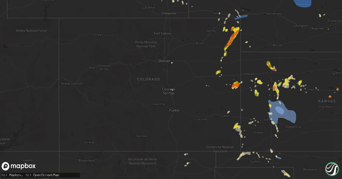
Hail Map on May 30, 2023
Get this storm
May 30 map
$229
one time, instant access
Download today. No call, no setup
Keep the $229
Bought the map and want the full workflow? Apply the entire $229 to a subscription within 7 days. None of it is wasted.
Every map, not just this one
This buys you this map. Subscription and you get every map we run, in the markets you choose from a few cities to whole states to nationwide. Plus real-time alerts the moment a storm fires.
Contact data
Name, contact info, occupancy, even credit band for addresses in the footprint. You go from where it hit to who to call.
Become the source they trust
Unlimited branding weather history reports on demand. You already have the documented answer ready for the property owner, and you are the one who showed up with it.
Property data and RoofTrace estimates
Pull up any address you have got, its value and the exact code rules for that jurisdiction, straight from One Click Code. Then RoofTrace estimates the squares, pitch, and roof value, priced the way you price.
States Impacted by Hail Map on May 30, 2023
Storm reports
Wyoming
| Date | Description |
|---|---|
| 05/30/20236:53 PM CDT | Asos station kdgw douglas airport - dgw. |
| 05/30/20232:58 PM CDT | A local report indicates 1.00 inch wind near BEULAH |
Kansas
| Date | Description |
|---|---|
| 05/30/20236:40 PM CDT | A local report indicates 1.00 inch wind near 4 S PARK |
| 05/30/20236:07 PM CDT | Social media image of quarter size hail. |
| 05/30/20235:55 PM CDT | Delayed report via social media. Some ping pong ball to golf ball sized hail reported mixed in with smaller pea to quarter sized hail. Hail destroyed flower beds and ga |
| 05/30/20235:55 PM CDT | Hail was dime to half dollar size hail. Ground was 50 percent covered. |
| 05/30/20235:40 PM CDT | Courtesy of kwch. Time estimated by radar. |
| 05/30/20235:35 PM CDT | A local report indicates 1.25 inch wind near 7 NNW OGALLAH |
| 05/30/20235:15 PM CDT | A local report indicates 1.00 inch wind near 3 NE CEDAR POINT |
| 05/30/20234:45 PM CDT | Delayed report. Time estimated from radar. 3-4 inch tree limb snapped. |
| 05/30/20234:45 PM CDT | A local report indicates 60 MPH wind near WILLARD |
| 05/30/20234:43 PM CDT | Half inch diameter tree limbs down. |
| 05/30/20234:35 PM CDT | A local report indicates 60 MPH wind near 3 NNW DOVER |
| 05/30/20234:25 PM CDT | A local report indicates 60 MPH wind near 3 WSW SAINT MARYS |
| 05/30/20234:14 PM CDT | Social media report. |
| 05/30/20234:06 PM CDT | Delayed report. |
| 05/30/20234:05 PM CDT | A local report indicates 60 MPH wind near 1 N ROSSVILLE |
| 05/30/20233:43 PM CDT | A local report indicates 1.00 inch wind near PEABODY |
| 05/29/202310:41 PM CDT | Mesonet station ur350 4.4 ne hayne |
| 05/29/202310:22 PM CDT | Report from mping: 1-inch tree limbs broken; shingles blown off. |
| 05/29/202310:15 PM CDT | Mesonet station sauk1 satanta. |
| 05/29/20239:36 PM CDT | On grain elevator from kake. |
| 05/29/20239:31 PM CDT | On grain elevator from kake. |
| 05/29/20239:15 PM CDT | Mesonet station ks010 us-50 @ k-156 bridge garden city. |
| 05/29/20239:08 PM CDT | From kake. |
| 05/29/20239:03 PM CDT | Asos station kgck garden city. |
| 05/29/20238:32 PM CDT | Spotter reported about 200 yds visibility in blowing dirt. |
| 05/29/20238:32 PM CDT | Numerous 4 inch tree limbs downed. |
| 05/29/20238:30 PM CDT | Mesonet station dw2812 scott city. |
| 05/29/20238:26 PM CDT | Reported 55 to 70 mph winds. |
| 05/29/20238:26 PM CDT | A local report indicates 1.00 inch wind near 2 E SCOTT CITY |
| 05/29/20238:20 PM CDT | Mesonet station ew9720 scott city. |
| 05/29/20238:15 PM CDT | Awos station ktqk scott city. |
| 05/29/20237:50 PM CDT | Delayed/relayed report of ping pong ball sized hail and 1.9 inches total rain. Time estimated from radar. |
Minnesota
| Date | Description |
|---|---|
| 05/30/20236:45 PM CDT | Pontoon boat and lift overturned on schoolcraft river. |
| 05/30/20236:40 PM CDT | Facebook report. |
| 05/30/20236:04 PM CDT | Report relayed via facebook. |
| 05/30/20235:57 PM CDT | Report from bowstring lake area of a large amount of hailstones ranging from pea size to quarter size. Time estimated from radar. |
| 05/30/20235:30 PM CDT | A local report indicates 1.25 inch wind near 3 ENE RICHVILLE |
| 05/30/20235:25 PM CDT | Becker county em reports nickels to quarters. |
| 05/30/20235:10 PM CDT | Social media report of quarter size hail. |
| 05/30/20235:10 PM CDT | Public report via facebook. |
| 05/30/20234:45 PM CDT | Largest stone was 1.25 with average around 1 inch. |
| 05/30/20234:45 PM CDT | Corrects previous hail report from 2 ne blackduck. 1-1.25 inch hail. |
| 05/30/20234:45 PM CDT | Half dollar to golf ball size hail reported via social media. |
| 05/30/20234:15 PM CDT | Grant county reports quarter size hail. |
| 05/30/20233:58 PM CDT | Corrects previous hail report from 3 w borup. Facebook report. |
| 05/30/20233:58 PM CDT | Facebook report. |
| 05/30/20233:30 PM CDT | Report relayed via twitter with a picture showing a handful of quarter sized hail and the approximate time. |
Colorado
| Date | Description |
|---|---|
| 05/30/20236:26 PM CDT | Report from mping: quarter |
| 05/30/20235:38 PM CDT | Soft hail. |
| 05/30/20235:07 PM CDT | Local report of tornado on the ground north of lamar. |
| 05/30/20235:05 PM CDT | 1/4 mile tornado debris field strewn in the 6000 block of cr mm. Barn blown down... Another damaged. 3 trees blown down and minor surface damage to one home. |
| 05/30/20235:03 PM CDT | Citizen reported landspout tornado on the ground near lamar. |
| 05/30/20235:00 PM CDT | Fire dept reported a landspout tornado on the ground near lamar. |
| 05/29/20239:22 PM CDT | A local report indicates 59 MPH wind near 2 SE JULESBURG |
| 05/29/20239:17 PM CDT | A local report indicates 1.00 inch wind near 3 WNW PLEASANT VALLEY |
| 05/29/20239:15 PM CDT | A local report indicates 1.75 inch wind near 3 WNW PLEASANT VALLEY |
| 05/29/20238:59 PM CDT | Soft hail... And just a few larger stones. |
| 05/29/20238:31 PM CDT | Report via facebook from wfo boulder. Time estimated via radar. |
South Dakota
| Date | Description |
|---|---|
| 05/30/20236:57 PM CDT | Mostly large pea size but a few quarters |
| 05/30/20236:42 PM CDT | Lots of quarters with a few golf ball size hail pieces. |
| 05/30/20236:00 PM CDT | Mostly dimes but a few quarters. |
| 05/30/20235:05 PM CDT | Mostly marble sized with a few quarters |
| 05/30/20234:48 PM CDT | Mostly smaller. Few one and one eight inch pieces. |
| 05/30/20234:47 PM CDT | Mostly dimes and nickels but a few quarters. |
| 05/30/20233:58 PM CDT | Mostly nickels. Couple quarters. |
| 05/29/202310:15 PM CDT | Corrects previous tstm wnd gst report from 3 w okaton. Estimated 50 to 60 mph wind gusts. Radar estimated time. |
| 05/29/20239:59 PM CDT | A local report indicates 63 MPH wind near 9 ENE BELVIDERE |
| 05/29/20239:40 PM CDT | Strong winds began at 840 pm and lasted 10 minutes. |
| 05/29/20238:59 PM CDT | A local report indicates 62 MPH wind near 4 E CACTUS FLAT |
| 05/29/20238:10 PM CDT | A local report indicates 1.50 inch wind near 14 NNE ROCKYFORD |
| 05/29/20237:06 PM CDT | A local report indicates 63 MPH wind near 3 ESE PINE RIDGE |
Nebraska
| Date | Description |
|---|---|
| 05/30/202312:30 AM CDT | 58 mph wind gusts started at 1223 am and continued through 1230 am. |
| 05/29/202311:39 PM CDT | A local report indicates 60 MPH wind near 1 E NORTH PLATTE |
| 05/29/202311:39 PM CDT | Large tree limb down. |
| 05/29/202311:09 PM CDT | At home weather station... Old miller school... Reported 65 mph wind gust. |
| 05/29/202311:09 PM CDT | 65 mph on at home weather station. |
| 05/29/202310:44 PM CDT | Report via at home weather sensor. |
| 05/29/20239:00 PM CDT | Public reports 70 mph wind gust. |
| 05/29/20238:58 PM CDT | Report of 60 to 65 mph winds... Also heavy rainfall observed but no amount given. |
| 05/29/20237:38 PM CDT | A local report indicates 1.00 inch wind near 5 SSW GORDON |
| 05/29/20237:10 PM CDT | Awos station k1cw 9 e harrisburg. |
Oklahoma
| Date | Description |
|---|---|
| 05/30/20231:35 AM CDT | Mesonet station arne arnett. |
| 05/30/20231:20 AM CDT | Mesonet station arne arnett. |
| 05/29/202311:50 PM CDT | Four power poles broken and laid over. |
| 05/29/202311:50 PM CDT | Pickup with trailer pushed over. |
| 05/29/202311:20 PM CDT | Tree limbs broken and knocked over... Both large and small. One tree was blown over on the road... And blocked traffic temporarily. |
| 05/29/202311:20 PM CDT | A local report indicates 71 MPH wind near 1 SSW BEAVER |
New Mexico
| Date | Description |
|---|---|
| 05/29/20238:55 PM CDT | Gerald satterwhite reported hailstones around one inch. Severe thunderstorm warning in effect from 1937 lt to 2015 lt. |
Texas
| Date | Description |
|---|---|
| 05/30/20235:18 AM CDT | Time estimated by radar. |
Cities Impacted by Hail Map on May 30, 2023
- Spearfish, SD
- Beulah, WY
- Ord, NE
- North Loup, NE
- Fairmont, NE
- Martin, SD
- Lead, SD
- Bremen, KS
- Deadwood, SD
- Milligan, NE
- Valentine, NE
- Saint Libory, NE
- Rapid City, SD
- Home, KS
- Tuthill, SD
- Aurora, NE
- Vermillion, KS
- Ada, MN
- Gary, MN
- Fertile, MN
- Georgetown, MN
- Borup, MN
- Council Grove, KS
- Peabody, KS
- Winger, MN
- Belvue, KS
- Wamego, KS
- Rossville, KS
- Paxico, KS
- Saint Marys, KS
- Maple Hill, KS
- Silver Lake, KS
- Topeka, KS
- Elbow Lake, MN
- Hermosa, SD
- Caputa, SD
- Elmdale, KS
- Arapahoe, CO
- Burlington, CO
- Blackduck, MN
- Hines, MN
- Fosston, MN
- Lengby, MN
- Bagley, MN
- Northome, MN
- Kelliher, MN
- Wakeeney, KS
- Ogallah, KS
- Morland, KS
- Cottonwood Falls, KS
- Burrton, KS
- Ottertail, MN
- Perham, MN
- New York Mills, MN
- Winona, KS
- Rexford, KS
- Colby, KS
- Ellis, KS
- Palco, KS
- Aladdin, WY
- Ragley, LA
- Laurens, IA
- Westboro, MO
- Rock Port, MO
- Tarkio, MO
- Nortonville, KS
- Effingham, KS
- Donnelly, MN
- Walhalla, ND
- Mahnomen, MN
- Lancaster, MN
- Waverly, MN
- Bison, SD
- Wendell, MN
- Frisco, TX
- Alzada, MT
- Richville, MN
- Scranton, IA
- Jefferson, IA
- Churdan, IA
- Little Elm, TX
- Fort Laramie, WY
- Hamlin, IA
- Audubon, IA
- Onaga, KS
- Bell City, LA
- Centralia, KS
- Table Rock, NE
- Emmetsburg, IA
- Langdon, ND
- Montrose, MN
- Buffalo, MN
- Ogema, MN
- Wheatland, WY
- Hiawatha, KS
- Bejou, MN
- Twin Valley, MN
- Ulen, MN
- Meriden, KS
- Kirbyville, TX
- Buna, TX
- Paton, IA
- White Owl, SD
- Alma, KS
- Dallas, TX
- Scranton, KS
- Wakarusa, KS
- Carbondale, KS
- Burdick, KS
- Raton, NM
- Carrollton, TX
- Red Lake Falls, MN
- Cedar Point, KS
- Florence, KS
- Sundance, WY
- Abbeville, LA
- Celina, TX
- Irving, TX
- Dawson, NE
- Humboldt, NE
- Mcpherson, KS
- Windom, KS
- Call, TX
- Aurora, CO
- Watkins, CO
- Stella, NE
- Auburn, NE
- Nemaha, NE
- Hesston, KS
- Newton, KS
- Armstrong, IA
- Perley, MN
- Coppell, TX
- Delia, KS
- Evansville, MN
- Pilot Point, TX
- Alta Vista, KS
- Strong City, KS
- Bloomfield, MT
- Craig, MO
- Verdon, NE
- Nacogdoches, TX
- Grand Prairie, TX
- Brownville, NE
- Watson, MO
- Colorado Springs, CO
- Selden, KS
- Quinter, KS
- Hoxie, KS
- Deer River, MN
- Glencoe, MN
- Plato, MN
- Lester Prairie, MN
- Young America, MN
- Roosevelt, MN
- Warroad, MN
- Scenic, SD
- Nemo, SD
- Conchas Dam, NM
- Tucumcari, NM
- Cheyenne Wells, CO
- Atwood, KS
- Park, KS
- Grainfield, KS
- Piedmont, SD
- Hoisington, KS
- Claflin, KS
- Mosquero, NM
- Sylvan Grove, KS
- Wilson, KS
- Ellsworth, KS
- Lincoln, KS
- Holly, CO
- Granada, CO
- Wallace, KS
- Leoti, KS
- Gordon, NE
- Merriman, NE
- Haxtun, CO
- Yuma, CO
- Eckley, CO
- Flagler, CO
- Seibert, CO
- Grinnell, KS
- Gove, KS
- Wall, SD
- Pine Ridge, SD
- Wray, CO
- Scott City, KS
- Garden City, KS
- Healy, KS
- Dighton, KS
- Kyle, SD
- Wanblee, SD
- Holyoke, CO
- Clovis, NM
- Cimarron, KS
- Jetmore, KS
- Palisade, MN
- Mcgregor, MN
- Aitkin, MN
- Chisholm, MN
- Britt, MN
- Ashby, NE
- Hyannis, NE
- Amherst, CO
- Holcomb, KS
- Ingalls, KS
- Interior, SD
- Kadoka, SD
- Long Valley, SD
- Whitman, NE
- Beeler, KS
- Pierceville, KS
- Milesville, SD
- Mullen, NE
- Julesburg, CO
- Brule, NE
- Venango, NE
- Big Springs, NE
- Dodge City, KS
- Wright, KS
- Ogallala, NE
- Felton, MN
- Belvidere, SD
- White River, SD
- Seneca, NE
- Thedford, NE
- Hawk Springs, WY
- Bouton, IA
- Naytahwaush, MN
- Grand Junction, IA
- Rippey, IA
- Bemidji, MN
- Cook, MN
- Angora, MN
- Sidney, NE
- Erath, LA
- Askov, MN
- Bruno, MN
- Buffalo, SD
- Reva, SD
- Bovey, MN
- Nashwauk, MN
- Squaw Lake, MN
- Chadron, NE
- Whitney, NE
- Cherry Creek, SD
- Richmond, KS
- Princeton, KS
- Lane, KS
- Rantoul, KS
- Burlingame, KS
- Side Lake, MN
- Hibbing, MN
- Edson, KS
- Auburn, KS
- Moundville, MO
- Chokio, MN
- Hay Springs, NE
- Laporte, MN
- Cass Lake, MN
- Waubun, MN
- Floodwood, MN
- Wright, MN
- Brookston, MN
- Goodland, KS
- Anita, IA
- Exira, IA
- Brayton, IA
- Cheyenne, WY
- Dolliver, IA
- Trementina, NM
- Douglas, WY
- Bigfork, MN
- Hackberry, LA
- Lenexa, KS
- Troy, KS
- Oregon, MO
- Cleveland, TX
- Crawford, NE
- Capitol, MT
- Garnett, KS
- Williamsburg, KS
- Kendall, KS
- Lakin, KS
- Shevlin, MN
- Crook, CO
- Sedgwick, CO
- Manter, KS
- Walsh, CO
- Sharon Springs, KS
- Hansen, ID
- Bena, MN
- Marcell, MN
- Talmoon, MN
- Monument, KS
- Oakley, KS
- Wagon Mound, NM
- Lake Charles, LA
- Cameron, LA
- Lamar, CO
- Lagrange, WY
- Quenemo, KS
- Spring Hill, KS
- Ogden, IA
- Beaver, IA
- Crosslake, MN
- Hays, KS
- Greenwood, MO
- Lees Summit, MO
- Ottawa, KS
- Buhler, KS
- Collyer, KS
- Roseau, MN
- Wannaska, MN
- Corrigan, TX
- Pleasant Hill, MO
- Perry, IA
- Miami, FL
- Albin, WY
- Dallas Center, IA
- Pennington, MN
- Hill City, KS
- Moscow, TX
- Groveton, TX
- Bard, NM
- San Jon, NM
- Pomona, KS
- Solano, NM
- Meriden, WY
- Stuart, IA
- Redfield, IA
- Dawson, IA
- Nevada, MO
- Atchison, KS
- Prairie Village, KS
- Overland Park, KS
- Garita, NM
- Olathe, KS
- Weskan, KS
- Tenstrike, MN
- Paola, KS
- Gardner, KS
- Marquez, TX
- Martinsville, MO
- Bethany, MO
- Greeley, KS
- Solway, MN
- Kit Carson, CO
- Halstead, KS
- Ochopee, FL
- Pocatello, ID
- Parks, NE
- Penokee, KS
- Beaver, OK
- Stapleton, NE
- Halsey, NE
- Brewster, NE
- Dunning, NE
- Purdum, NE
- Arnold, NE
- Anselmo, NE
- Broken Bow, NE
- Merna, NE
- Ansley, NE
- Callaway, NE
- Westerville, NE
- Comstock, NE
- Sargent, NE
- Taylor, NE
- Vega, TX
- Adrian, TX
- Claude, TX
- Clarendon, TX
- Hill City, MN
- Swatara, MN
- Goodwell, OK
- Hooker, OK
- Pengilly, MN
- Forbes, MN
- Wellsville, KS
- Liberal, KS
- Hugoton, KS
- Turpin, OK
- Keyes, OK
- Champion, NE
- Guymon, OK
- Ravenna, NE
- Hazard, NE
- Kenesaw, NE
- Balko, OK
- Rockville, NE
- Victoria, KS
- Sunray, TX
- Copeland, KS
- Johnstown, NE
- Baldwin City, KS
- Sublette, KS
- Fredonia, KS
- Plains, KS
- Tryon, NE
- Kincaid, KS
- Chappell, NE
- Toronto, KS
- Walker, KS
- Winner, SD
- Forgan, OK
- Dumas, TX
- Concordia, KS
- Amarillo, TX
- Groom, TX
- Panhandle, TX
- Wildorado, TX
- Canyon, TX
- Horton, KS
- Robinson, KS
- Channing, TX
- Hartley, TX
- Fall River, KS
- Mayetta, KS
- Westphalia, KS
- Berryton, KS
- Frankfort, KS
- Pampa, TX
- Le Roy, KS
- Higgins, TX
- Follett, TX
- Booker, TX
- Lipscomb, TX
- Blue Rapids, KS
- Westmoreland, KS
- Emmett, KS
- Wheeler, TX