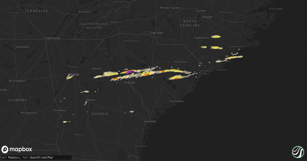
Hail Map in South Carolina on May 29, 2017
Get this storm
May 29 map
$229
one time, instant access
Download today. No call, no setup
Keep the $229
Bought the map and want the full workflow? Apply the entire $229 to a subscription within 7 days. None of it is wasted.
Every map, not just this one
This buys you this map. Subscription and you get every map we run, in the markets you choose from a few cities to whole states to nationwide. Plus real-time alerts the moment a storm fires.
Contact data
Name, contact info, occupancy, even credit band for addresses in the footprint. You go from where it hit to who to call.
Become the source they trust
Unlimited branding weather history reports on demand. You already have the documented answer ready for the property owner, and you are the one who showed up with it.
Property data and RoofTrace estimates
Pull up any address you have got, its value and the exact code rules for that jurisdiction, straight from One Click Code. Then RoofTrace estimates the squares, pitch, and roof value, priced the way you price.
Storm reports in South Carolina
South Carolina
| Date | Description |
|---|---|
| 05/29/20176:58 PM CDT | Schp reports trees down sc-261 and belles mill rd. |
| 05/29/20176:43 PM CDT | Schp reports trees in roadway along hwy 176. |
| 05/29/20176:43 PM CDT | Schp reports power lines in roadway hwy 176 and geiger lane. |
| 05/29/20176:40 PM CDT | Tree down on structure 201 st andrews rd. |
| 05/29/20176:37 PM CDT | Mping report of golf-ball size hail. |
| 05/29/20176:35 PM CDT | 60-mph wind gust reported at columbia metro airport asos. |
| 05/29/20176:21 PM CDT | Public reported over one dozen trees either uprooted or snapped. One tree fell on a house. |
| 05/29/20176:18 PM CDT | A large oak tree was brought down... With small hail and estimated wind speeds up to 75 mph. Reported at bridgewood ct... Gilbert... Sc. |
| 05/29/20176:10 PM CDT | Highway patrol reported trees down two notch road and oscar price road. |
| 05/29/20176:08 PM CDT | Numerous treed uprooted and snapped off on dixired road... Buck smith road and providence road in leesville. Several trees down on houses. Time estimated from radar. |
| 05/29/20176:03 PM CDT | Trained spotter reports trees down s. Lee street and fallaws lane. |
| 05/29/20175:37 PM CDT | Baseball size hail report on lee street. Received via social media. |
| 05/29/20175:31 PM CDT | 1 to 2-inch hail reported on long cane road along edgefield and saluda county line. |
| 05/29/20175:30 PM CDT | Edgefield county em reports hail ranging from pea-size to a little larger than golf-ball size. Several reports of damaged vehicles. Major impact area long cane rd and h |
| 05/29/20175:20 PM CDT | Edgefield county dispatch reports multiple trees down hwy 25 and hwy 283 intersection area. |
| 05/29/20175:20 PM CDT | Golf ball-size hail reported on hwy 25 nw of edgefield. Received via social media. |
| 05/29/20175:20 PM CDT | Edgefield county dispatch reports golf-ball size hail observed hwy 25 and hwy 283 intersection area. |
| 05/29/20175:18 PM CDT | Schp reports tree in roadway sc283 and walker road. |
| 05/29/20175:14 PM CDT | Reported quarter size hail at the lake thurmond visitors center. |
| 05/29/20175:12 PM CDT | 1.5-inch hail reported on jones road. Received via social media. |
| 05/29/20175:12 PM CDT | Edgefield county em reports baseball-size hail hwy 25 and hwy 378. |
| 05/29/20174:50 PM CDT | Ham radio operator reports trees down plum branch rd/hwy 230. |
| 05/28/20179:43 PM CDT | 3 trees down on several farm properties near county road 22-45 and south holland road. |
| 05/28/20178:55 PM CDT | Report of a tree down in roadway on indiantown rd. Time estimated by radar. |
| 05/28/20178:51 PM CDT | Public reported small dents in vehicle from hail along coleman road. |
| 05/28/20178:33 PM CDT | Highway patrol reported trees down us 378 and patriot pkway. |
| 05/28/20178:33 PM CDT | Highway patrol reported trees down 2700 north main street north of sumter. |
| 05/28/20178:24 PM CDT | Report of quarter sized hail in lake city. Time estimated by radar. |
| 05/28/20177:55 PM CDT | Highway patrol reported trees down 9333 columbia rd. |
| 05/28/20177:53 PM CDT | Clarendon county sheriff reported trees down across walker gamble road near turbeville. |
| 05/28/20177:49 PM CDT | Highway patrol reported trees down baker mill lake lane and old sandy run road. |
| 05/28/20177:37 PM CDT | Schp reports trees down on hwy 378 at patriot parkway. |
| 05/28/20177:31 PM CDT | Highway patrol reported trees down east brewington rd and blossom view dr. |
| 05/28/20177:12 PM CDT | Quarter size hail and estimated 50 mph winds on ridgehill drive. |
All States Impacted by Hail Map on May 29, 2017
Cities Impacted by Hail Map on May 29, 2017
- Swansea, SC
- Rocksprings, TX
- Fairburn, GA
- Atlanta, GA
- Red Oak, GA
- Union City, GA
- Tignall, GA
- Lincolnton, GA
- Rayle, GA
- Washington, GA
- Clinton, NC
- Lake City, SC
- Cades, SC
- New Zion, SC
- Turbeville, SC
- Tar Heel, NC
- Edgefield, SC
- Johnston, SC
- Clarks Hill, SC
- Eastover, SC
- Manning, SC
- Greeleyville, SC
- Salters, SC
- Thomson, GA
- Batesburg, SC
- Ridge Spring, SC
- Monetta, SC
- Appling, GA
- Ward, SC
- Wilmington, NC
- Hampstead, NC
- Holly Ridge, NC
- Cobbtown, GA
- Modoc, SC
- Aberdeen, NC
- Fort Bragg, NC
- Del Rio, TX
- Sumter, SC
- Harlem, GA
- McCormick, SC
- Troy, SC
- Aiken, SC
- Trenton, SC
- Model, CO
- Gaston, SC
- Ivanhoe, NC
- Willard, NC
- Harrells, NC
- Pelion, SC
- Saluda, SC
- Lumberton, NC
- Saint Pauls, NC
- White Oak, NC
- Elizabethtown, NC
- Lexington, SC
- Wagener, SC
- Leesville, SC
- Hopkins, SC
- Columbia, SC
- Kingstree, SC
- Greensboro, GA
- Madison, GA
- Union Point, GA
- Ozona, TX
- Fort Stockton, TX
- Marathon, TX
- Dryden, TX
- Green Sea, SC
- Gilbert, SC
- Lexington, GA
- Mayesville, SC
- Gable, SC
- Wedgefield, SC
- Juliette, GA
- Monticello, GA
- Forsyth, GA
- Wallace, NC
- Garland, NC
- Perry, GA
- Molena, GA
- Hubert, NC
- Folsom, NM
- Granada, CO
- North Augusta, SC
- Anton Chico, NM
- Nesmith, SC
- Summerton, SC
- Hemingway, SC
- Warm Springs, GA
- Leland, NC
- Tucumcari, NM
- Aurora, CO
- Conway, SC
- Richland, GA
- Lumpkin, GA
- Hamilton, GA
- Byron, GA
- Lizella, GA
- Fort Valley, GA
- Statesboro, GA
- Walsh, CO
- Animas, NM
- Salt Flat, TX
- North, SC
- Supply, NC
- Palmetto, GA
- Faison, NC
- Turkey, NC
- Scranton, SC
- Olanta, SC
- Junction, TX
- Watkinsville, GA
- Pinewood, SC
- Warsaw, NC
- Manter, KS
- West Columbia, SC
- Brackettville, TX
- Barnesville, GA
- Tappahannock, VA
- Raton, NM
- Evans, GA
- Cayce, SC
- Johnsonville, SC
- Pamplico, SC
- Norwood, GA
- Lynchburg, SC
- Alcolu, SC
- Gadsden, SC
- Crawfordville, GA
- Plum Branch, SC
- Eatonton, GA
- Ashtabula, OH
- Las Vegas, NM
- Sneads Ferry, NC
- Candor, NC
- Ellerbe, NC
- Jackson Springs, NC
- Haddock, GA
- Loris, SC
- Salemburg, NC
- Roseboro, NC
- Gresham, SC
- Register, GA
- Stephens, GA
- Westcliffe, CO
- Whiteville, NC
- Ellaville, GA
- Tabor City, NC
- Preston, GA
- Sapello, NM
- Rocky Point, NC
- Metter, GA
- Pulaski, GA
- Marfa, TX
- Fort Davis, TX


