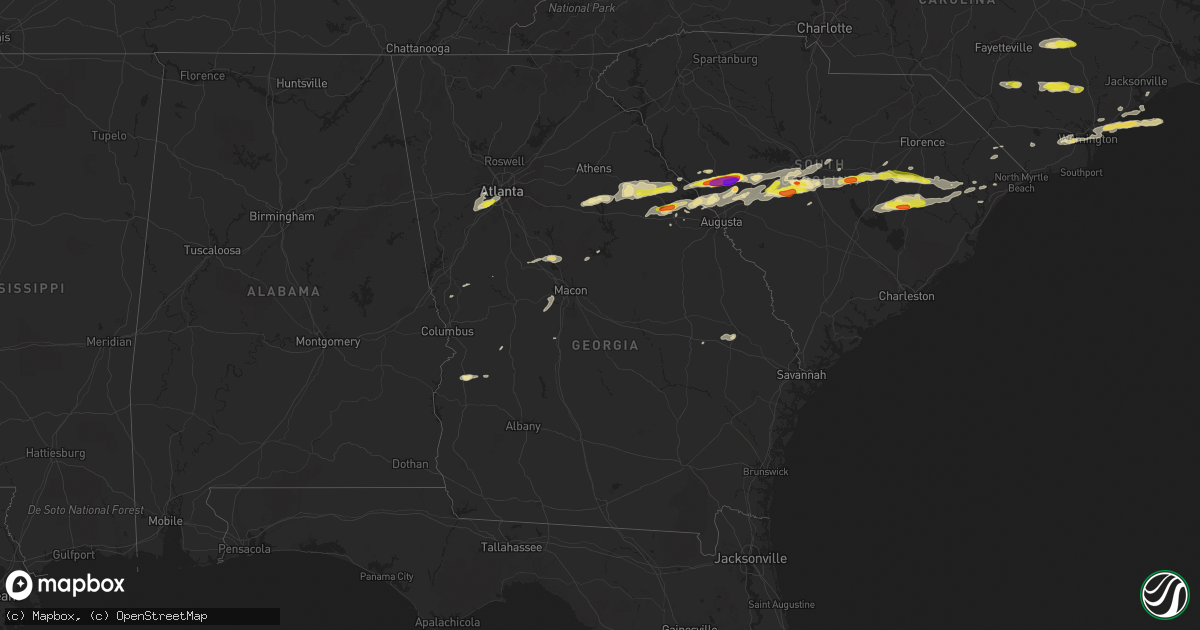
Hail Map in Georgia on May 29, 2017
Get this storm
May 29 map
$229
one time, instant access
Download today. No call, no setup
Keep the $229
Bought the map and want the full workflow? Apply the entire $229 to a subscription within 7 days. None of it is wasted.
Every map, not just this one
This buys you this map. Subscription and you get every map we run, in the markets you choose from a few cities to whole states to nationwide. Plus real-time alerts the moment a storm fires.
Contact data
Name, contact info, occupancy, even credit band for addresses in the footprint. You go from where it hit to who to call.
Become the source they trust
Unlimited branding weather history reports on demand. You already have the documented answer ready for the property owner, and you are the one who showed up with it.
Property data and RoofTrace estimates
Pull up any address you have got, its value and the exact code rules for that jurisdiction, straight from One Click Code. Then RoofTrace estimates the squares, pitch, and roof value, priced the way you price.
Storm reports in Georgia
Georgia
| Date | Description |
|---|---|
| 05/29/20176:36 PM CDT | Report of a tree blown down on veazey st in union point |
| 05/29/20176:22 PM CDT | County dispatch reported trees down near berzelia rd and newmantown rd intersection. |
| 05/29/20175:45 PM CDT | Quarter-size hail reported on elberton highway. |
| 05/29/20175:24 PM CDT | Report of a tree blown down on hall rd 3 miles wnw of lowery |
| 05/29/20175:20 PM CDT | Tree blown down over roadway on tignall rd at mm 15... One vehical involved in an accident but no injuies |
| 05/29/20175:20 PM CDT | Tree/tree limbs down at pope st... Orchard st... N alexander ave... And barnett st. Power outages reported in various areas in washington and in the county |
| 05/29/20174:53 PM CDT | Report of a tree blown down on veazey st in union point |
| 05/29/20174:53 PM CDT | Report of a tree blown down on athens hwy in union point |
| 05/29/20174:53 PM CDT | Report of a tree blown down on hilliard st in union point |
| 05/29/20174:50 PM CDT | Report of a tree blown down in woodville on e peachtree ave and hwy 77 |
| 05/29/20174:27 PM CDT | Lincoln county emergency manager reported trees down on hwy 378. |
| 05/29/20173:55 PM CDT | Tree blown down in washington at s alexander and baltimore rd |
| 05/29/20173:55 PM CDT | Tree was blown over in washington along baker st |
| 05/29/20173:10 PM CDT | Tree reported down on churchill rd in the 2000 block. |
| 05/29/20172:55 PM CDT | Tree was blown over in washington along baker st |
| 05/29/20172:55 PM CDT | Tree blown down in washington at s alexander and baltimore rd |
| 05/29/20172:05 PM CDT | Report via twitter of a tree blown down on redwine rd near princeton lakes parkway |
All States Impacted by Hail Map on May 29, 2017
Cities Impacted by Hail Map on May 29, 2017
- Swansea, SC
- Rocksprings, TX
- Fairburn, GA
- Atlanta, GA
- Red Oak, GA
- Union City, GA
- Tignall, GA
- Lincolnton, GA
- Rayle, GA
- Washington, GA
- Clinton, NC
- Lake City, SC
- Cades, SC
- New Zion, SC
- Turbeville, SC
- Tar Heel, NC
- Edgefield, SC
- Johnston, SC
- Clarks Hill, SC
- Eastover, SC
- Manning, SC
- Greeleyville, SC
- Salters, SC
- Thomson, GA
- Batesburg, SC
- Ridge Spring, SC
- Monetta, SC
- Appling, GA
- Ward, SC
- Wilmington, NC
- Hampstead, NC
- Holly Ridge, NC
- Cobbtown, GA
- Modoc, SC
- Aberdeen, NC
- Fort Bragg, NC
- Del Rio, TX
- Sumter, SC
- Harlem, GA
- McCormick, SC
- Troy, SC
- Aiken, SC
- Trenton, SC
- Model, CO
- Gaston, SC
- Ivanhoe, NC
- Willard, NC
- Harrells, NC
- Pelion, SC
- Saluda, SC
- Lumberton, NC
- Saint Pauls, NC
- White Oak, NC
- Elizabethtown, NC
- Lexington, SC
- Wagener, SC
- Leesville, SC
- Hopkins, SC
- Columbia, SC
- Kingstree, SC
- Greensboro, GA
- Madison, GA
- Union Point, GA
- Ozona, TX
- Fort Stockton, TX
- Marathon, TX
- Dryden, TX
- Green Sea, SC
- Gilbert, SC
- Lexington, GA
- Mayesville, SC
- Gable, SC
- Wedgefield, SC
- Juliette, GA
- Monticello, GA
- Forsyth, GA
- Wallace, NC
- Garland, NC
- Perry, GA
- Molena, GA
- Hubert, NC
- Folsom, NM
- Granada, CO
- North Augusta, SC
- Anton Chico, NM
- Nesmith, SC
- Summerton, SC
- Hemingway, SC
- Warm Springs, GA
- Leland, NC
- Tucumcari, NM
- Aurora, CO
- Conway, SC
- Richland, GA
- Lumpkin, GA
- Hamilton, GA
- Byron, GA
- Lizella, GA
- Fort Valley, GA
- Statesboro, GA
- Walsh, CO
- Animas, NM
- Salt Flat, TX
- North, SC
- Supply, NC
- Palmetto, GA
- Faison, NC
- Turkey, NC
- Scranton, SC
- Olanta, SC
- Junction, TX
- Watkinsville, GA
- Pinewood, SC
- Warsaw, NC
- Manter, KS
- West Columbia, SC
- Brackettville, TX
- Barnesville, GA
- Tappahannock, VA
- Raton, NM
- Evans, GA
- Cayce, SC
- Johnsonville, SC
- Pamplico, SC
- Norwood, GA
- Lynchburg, SC
- Alcolu, SC
- Gadsden, SC
- Crawfordville, GA
- Plum Branch, SC
- Eatonton, GA
- Ashtabula, OH
- Las Vegas, NM
- Sneads Ferry, NC
- Candor, NC
- Ellerbe, NC
- Jackson Springs, NC
- Haddock, GA
- Loris, SC
- Salemburg, NC
- Roseboro, NC
- Gresham, SC
- Register, GA
- Stephens, GA
- Westcliffe, CO
- Whiteville, NC
- Ellaville, GA
- Tabor City, NC
- Preston, GA
- Sapello, NM
- Rocky Point, NC
- Metter, GA
- Pulaski, GA
- Marfa, TX
- Fort Davis, TX


