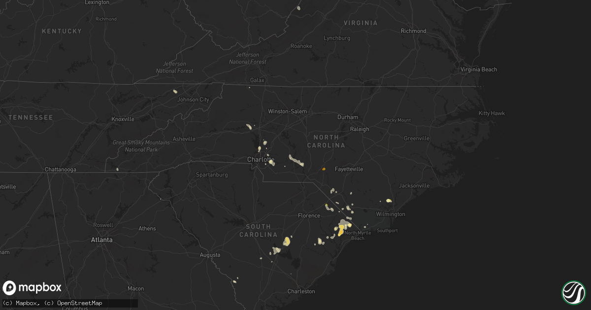
Hail Map in North Carolina on May 29, 2014
Get this storm
May 29 map
$229
one time, instant access
Download today. No call, no setup
Keep the $229
Bought the map and want the full workflow? Apply the entire $229 to a subscription within 7 days. None of it is wasted.
Every map, not just this one
This buys you this map. Subscription and you get every map we run, in the markets you choose from a few cities to whole states to nationwide. Plus real-time alerts the moment a storm fires.
Contact data
Name, contact info, occupancy, even credit band for addresses in the footprint. You go from where it hit to who to call.
Become the source they trust
Unlimited branding weather history reports on demand. You already have the documented answer ready for the property owner, and you are the one who showed up with it.
Property data and RoofTrace estimates
Pull up any address you have got, its value and the exact code rules for that jurisdiction, straight from One Click Code. Then RoofTrace estimates the squares, pitch, and roof value, priced the way you price.
Storm reports in North Carolina
North Carolina
| Date | Description |
|---|---|
| 05/29/20145:25 PM CDT | 1 tree down hayenridge ct |
| 05/29/20145:20 PM CDT | 1 tree down at intersection of hambright rd and montecarlo dr |
| 05/29/20145:00 PM CDT | A tree down on nc 51 near monroe road. |
| 05/29/20144:40 PM CDT | A local report indicates 1.00 inch wind near 4 ESE MINT HILL |
| 05/29/20144:15 PM CDT | Rooftop ripped off a barn on hartland rd in the chesterfield community north of morganton. Time estimated from radar. |
| 05/29/20144:10 PM CDT | Trees and power lines down on nc hwy 18 near johns river. |
| 05/29/20144:10 PM CDT | A tree down on house intersection of nc hwy 18 and antioch rd. |
| 05/29/20143:45 PM CDT | Numerous 2-3 inch diameter branches down in riverbend park |
| 05/29/20143:30 PM CDT | Nickel to quarter size hail fell. Did not cover the ground. |
| 05/29/20143:30 PM CDT | Trees down on brickyard road in norwood. Time estimated by radar. |
| 05/29/20143:15 PM CDT | Power pole down on east washington street. |
| 05/29/20143:07 PM CDT | Hail to the size of quarters was reported. |
| 05/29/20143:00 PM CDT | A tree was reported down and blocking locklear road. The fire department was called to remove the tree. |
| 05/29/20142:15 PM CDT | Hail up to the size of ping pong balls at walhalla farm |
All States Impacted by Hail Map on May 29, 2014
Cities Impacted by Hail Map on May 29, 2014
- Dickinson, ND
- Belfield, ND
- Reeder, ND
- Valdosta, GA
- Regent, ND
- Lake Butler, FL
- Immokalee, FL
- Dillon, SC
- Fork, SC
- Latta, SC
- Trenton, FL
- Newberry, FL
- Starke, FL
- Gresham, SC
- Conway, SC
- Allendale, SC
- Homosassa, FL
- Hazen, ND
- Casper, WY
- Galivants Ferry, SC
- Aynor, SC
- Amidon, ND
- Johnsonville, SC
- Hemingway, SC
- Mooresville, NC
- Fort Meade, SD
- Sturgis, SD
- Whitewood, SD
- Vale, SD
- Beulah, ND
- Richardton, ND
- Zap, ND
- Hilliard, FL
- Bladenboro, NC
- Statesville, NC
- Gladstone, ND
- Mott, ND
- Lefor, ND
- New England, ND
- Hettinger, ND
- Lake Park, GA
- Rocky Point, NC
- Lake Panasoffkee, FL
- Halliday, ND
- Burgaw, NC
- Church Hill, TN
- Rogersville, TN
- Newcastle, WY
- Charlotte, NC
- Matthews, NC
- Indian Trail, NC
- Huntersville, NC
- Cornelius, NC
- Brooker, FL
- Hebron, ND
- Taylor, ND
- New Holland, IL
- Mason City, IL
- Gainesville, FL
- Tampa, FL
- Piedmont, SD
- Nemo, SD
- Newell, SD
- Wauchula, FL
- Zolfo Springs, FL
- Lavonia, GA
- Rowland, NC
- Pembroke, NC
- Maxton, NC
- Avon Park, FL
- Sebring, FL
- Loris, SC
- Nichols, SC
- Manning, SC
- Mount Gilead, NC
- Bowman, SC
- Land O'Lakes, FL
- High Springs, FL
- Green Sea, SC
- Tabor City, NC
- Lodgepole, SD
- Alcolu, SC
- Easton, IL
- Clarendon, NC
- Whiteville, NC
- Chadbourn, NC
- Alachua, FL
- Cerro Gordo, NC
- Punta Gorda, FL
- Garrison, ND
- Archer, FL
- Kannapolis, NC
- Douglas, WY
- Sumterville, FL
- Wildwood, FL
- Covington, VA
- Marshville, NC
- Peachland, NC
- Kelly, NC
- Atkinson, NC
- Concord, NC
- Summerton, SC
- Folkston, GA
- Buffalo, SD
- Prairie City, SD
- Stony Point, NC
- Norwood, NC
- Taylorsville, NC
- Nisland, SD
- Davidson, NC
- Wallace, SC
- Brooksville, FL
- Lake City, FL
- Surgoinsville, TN
- Dodge, ND
- Saint George, GA
- Lumberton, NC
- Golden Valley, ND
- Bushnell, FL
- Fort Myers, FL
- Lake Placid, FL
- Elloree, SC
- Cameron, SC
- Summerville, SC
- Inverness, FL
- Floral City, FL
- Hampton, FL
- Odessa, FL
- Moultrie, GA
- Murphy, NC
- Monroe, NC
- Ocean Isle Beach, NC
- Ash, NC
- Fairmont, NC
- Sparta, NC
- Nesmith, SC
- Santee, SC
- Harrisburg, NC
- South Heart, ND
- Union Center, SD
- Gillette, WY
- Jesup, GA
- Thonotosassa, FL
- Plant City, FL
- Wesley Chapel, FL
- San Antonio, FL
- Albemarle, NC
- Glenrock, WY
- Kingstree, SC
- Fair Bluff, NC
- Rowesville, SC
- Coolidge, GA
- Okeechobee, FL
- Frostproof, FL
- Longwood, NC
- Medora, ND
- Fort Meade, FL
- Aberdeen, NC
- Wagram, NC
- Raeford, NC


